close
-
Layers w
- Weather Layers
- Pro
- Pro
- Pro
- Pro
- Pro
- Pro
- More Layers
- Pro
- Pro
- Pro
- Pro
-
Upgrade to

3D
Trail Conditions
- Unknown
- Snow Groomed
- Snow Packed
- Snow Covered
- Snow Cover Partial
- Freeze/thaw Cycle
- Icy
- Prevalent Mud
- Wet
- Variable
- Ideal
- Dry
- Very Dry
Trail Flow (Ridden Direction)
Trailforks scans users ridelogs to determine the most popular direction each trail is ridden. A good flowing trail network will have most trails flowing in a single direction according to their intension.
The colour categories are based on what percentage of riders are riding a trail in its intended direction.
The colour categories are based on what percentage of riders are riding a trail in its intended direction.
- > 96%
- > 90%
- > 80%
- > 70%
- > 50%
- < 50%
- bi-directional trail
- no data
Trail Last Ridden
Trailforks scans ridelogs to determine the last time a trail was ridden.
- < 2 days
- < 1 week
- < 2 weeks
- < 1 month
- < 6 months
- > 6 months
Trail Ridden Direction
The intended direction a trail should be ridden.
- Downhill Only
- Downhill Primary
- Both Directions
- Uphill Primary
- Uphill Only
- One Direction
Contribute Details
Colors indicate trail is missing specified detail.
- Description
- Photos
- Description & Photos
- Videos
Trail Popularity ?
Trailforks scans ridelogs to determine which trails are ridden the most in the last 9 months.
Trails are compared with nearby trails in the same city region with a possible 25 colour shades.
Think of this as a heatmap, more rides = more kinetic energy = warmer colors.
- most popular
- popular
- less popular
- not popular
ATV/ORV/OHV Filter
Max Vehicle Width
inches
US Cell Coverage
Legend

Radar Time
Activity Recordings
Trailforks uses anonymized public activity data.
?
Activity Recordings
Trailforks uses anonymized public activity data.
?
Personal Heatmap
▶
Activity Types
all
/
none
▶
Options
2
Date range
month
–
Winter Trails
Warning
A routing network for winter maps does not exist. Selecting trails using the winter trails layer has been disabled.
Missing Trails
Most Popular
Least Popular
Trails are colored based on popularity. The more popular a trail is, the more red. Less popular trails trend towards green.
Jump Magnitude Heatmap
Heatmap of where riders jump on trails. Zoom in to see individual jumps, click circles to view jump details.
BC Backroad Status
![map legend]()
Service Road Atlas is a free to use, community-driven service for viewing and creating reports on the numerous back-country service roads around B.C. and Alberta.

Slope Aspect
Direction the slope faces
Trails Deemphasized
Trails are shown in grey.
Only show trails with no bike usage.
Suggested Layers
Based on selected activity type
Save the current map location and zoom level as your default home location whenever this page is loaded.
Save
No description for Topeka has been added yet!
Login or register to submit one.
Activities Click to view
- Mountain Bike
38 trails
- E-Bike
15 trails
- Gravel Bike
0 trails
- Adaptive Bike
0 trails
- Hike
36 trails
- Trail Running
36 trails
Region Details
- 9
- 8
- 18
- 3
Region Status
Open as of Aug 21, 2025Stats
- Avg Trail Rating
- Trails (view details)
- 38
- Trails Mountain Bike
- 38
- Trails E-Bike
- 15
- Trails Hike
- 36
- Trails Trail Running
- 36
- Total Distance
- 49 miles
- Total Descent
- 3,498 ft
- Total Vertical
- 289 ft
- Highest Trailhead
- 1,153 ft
- Reports
- 56
- Photos
- 83
- Ridden Counter
- 781
Sub Regions
-
Big Shunga Park
- 1
-
Dornwood Park
- 3
-
Lake Shawnee
-
MacLennan Park
- 6
- 9
- 3
-
Skyline Park
- 2
- 5
Popular Topeka Mountain Biking Trails
• 80 ★ 0.0 • 2 miles • 229 ft • 47 •
Popular blue difficulty singletrack. This mountain bike primary trail. On average it takes 12 minutes to complete this trail.
• 55 ★ 5.0 • 1 mile • 120 ft • 29 •
Moderately popular blue difficulty singletrack. This multi-use trail can be used both directions and has a easy overall physical rating with a 120 ft green climb. Trail visibility is always easy to follow. On average it takes 24 minutes to complete this trail.
• 40 ★ 0.0 • 3,839 ft • 66 ft • 24 •
Moderately popular blue difficulty singletrack. This multi-use trail can be used both directions. On average it takes 5 minutes to complete this trail.
• 90 ★ 5.0 • 1,240 ft • 0 ft • 24 •
Fast and flowy downhill trail with berms and jumps. Part of the Hornet's nest trails, access is behind the ranger station.
• 45 ★ 0.0 • 1 mile • 62 ft • 21 •
Moderately popular green difficulty singletrack. This mountain bike primary trail can be used both directions. On average it takes 12 minutes to complete this trail.
• 90 ★ 0.0 • 3,888 ft • 159 ft • 20 •
Wide gravel trail that winds through Kaw River State Park
• 50 ★ 0.0 • 2 miles • 117 ft • 19 •
Moderately popular blue difficulty singletrack. This mountain bike primary trail. On average it takes 13 minutes to complete this trail.
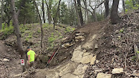
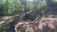
Photos of Topeka Mountain Bike
Videos of Topeka Mountain Bike
trail: Dirt Dauber
0:06 |
27 |
Sep 16, 2025
trail: Dirt Dauber
0:07 |
21 |
Sep 16, 2025
Recent Trail Reports
| status | trail | date | condition | info | user |
|---|---|---|---|---|---|
| Ichabod Way | Aug 21, 2025 @ 5:40pm Aug 21, 2025 | Unknown | beaner1124 | ||
| Dornwood Loop 1 | Jun 19, 2025 @ 5:45pm Jun 19, 2025 | Ideal | beaner1124 | ||
| Red Trail | May 1, 2025 @ 6:34pm May 1, 2025 | Variable | mtbkdtbg | ||
| Blue Trail | Apr 29, 2025 @ 6:05pm Apr 29, 2025 | Ideal | mtbkdtbg | ||
| Hornet's Nest Connector | Apr 29, 2025 @ 6:05pm Apr 29, 2025 | Ideal | mtbkdtbg | ||
| Dornwood Loop 2 | Sep 9, 2024 @ 5:48pm Sep 9, 2024 | Ideal | beaner1124 | ||
| NBR | Aug 18, 2024 @ 2:41am Aug 18, 2024 | Ideal | dabikerboy | ||
| Yellow Trail | May 21, 2024 @ 6:00am May 21, 2024 | Variable | mtbkdtbg | ||
| South Summit Sunset Connector | Sep 2, 2023 @ 3:37am Sep 2, 2023 | Dry | aaronsiebert | ||
| Sunset Loop | Sep 2, 2023 @ 3:37am Sep 2, 2023 | Dry | aaronsiebert |
Activity Feed
| username | action | type | title | date |
|---|---|---|---|---|
| Afrizz | update | trail | activity #92218827 | Apr 8, 2026 @ 4:26pm Apr 8, 2026 |
| Afrizz | update | trail | activity #92216441 and 2 more | Apr 8, 2026 @ 3:52pm Apr 8, 2026 |
| Jakey5112 | ridden | trail | activity #88777650 | Feb 12, 2026 @ 6:43am Feb 12, 2026 |
| Afrizz | add | trail | activity #85331970 | Dec 10, 2025 @ 2:46pm Dec 10, 2025 |
| benstagram | vote | trail | activity #80928222 | Sep 22, 2025 @ 6:29pm Sep 22, 2025 |
Recent Comments
| username | type | title | comment | date |
|---|---|---|---|---|
| trail | Good trail for a long walk and getting a few... | Nov 22, 2022 @ 3:02pm Nov 22, 2022 | ||
| trail | Bad experience. Can’t recommend this park.... | Aug 24, 2021 @ 12:21pm Aug 24, 2021 | ||
| trail | My wife and I were driving through Topeka on... | Oct 30, 2020 @ 3:44pm Oct 30, 2020 | ||
| trail | Fun little gravel trail. Fast run from the top... | May 3, 2018 @ 6:20am May 3, 2018 | ||
| trail | 2 nov 2017. Great little trails. More techy... | Nov 2, 2017 @ 12:14pm Nov 2, 2017 |
Local Badges
-

Epic Ride Climb 2k2 awarded -

Climbing 10k Badge9 awarded -

Climbing 100k Badge3 awarded -

Epic Ride Descent 2k2 awarded -

Descent 10k Badge9 awarded -

Descent 100k Badge3 awarded
Bike & Skill Parks
| name | type | city | rating |
|---|---|---|---|
| Heartland BMX Track | skill park | Topeka |
Activity Type Stats
| activitytype | trails | distance | descent | descent distance | total vertical | rating | global rank | state rank | photos | reports | routes | ridelogs |
|---|---|---|---|---|---|---|---|---|---|---|---|---|
| Mountain Bike | 38 | 49 miles | 3,497 ft | 20 miles | 289 ft | #3,167 | #1,086 | 41 | 56 | 5,023 | ||
| E-Bike | 15 | 5,203 ft | 20 ft | 817 ft | 95 ft | #7,720 | #2,328 | 31 | 98 | |||
| Hike | 36 | 49 miles | 3,327 ft | 20 miles | 289 ft | #2,925 | #1,075 | 45 | 49 | 109 | ||
| Trail Running | 36 | 49 miles | 3,327 ft | 20 miles | 289 ft | #4,518 | #1,393 | 49 | 85 |
Frequently Asked Questions About Topeka
▼
What are the best places to ride in Topeka?
Topeka has 5 areas to explore for mountain biking. The top rated areas are:
▼
What are the highest rated mountain biking trails in Topeka?
The highest rated mountain biking trails in Topeka are:
- Dirt Dauber (4.1/5)
- Hornets Haymaker (4.1/5)
- Red Trail (4.1/5)
- North Summit loop (4.1/5)
- Shunga Dirt (3.9/5)
▼
What is the best time of the year to ride in Topeka?
Based on ride log data, the most popular months to ride in Topeka are:
- July (35 activities)
- June (19 activities)
- November (18 activities)
▼
Where can I park to ride in Topeka?
There are 6 parking locations listed in Topeka. The most popular parking spots are: View all parking and trailhead locations on the map to plan your visit.
Activities
Trails
Points of Interest
- By markholloway
 Trailforks Map Team & contributors
 - Admins: TCTA
- #12599 - 3,957 views
- topeka activity log | embed map of Topeka mountain bike trails | topeka mountain biking points of interest
Downloading of trail gps tracks in kml & gpx formats is enabled for Topeka.
You must login to download files.