close
-
Layers w
- Weather Layers
- Pro
- Pro
- Pro
- Pro
- Pro
- Pro
- More Layers
- Pro
- Pro
- Pro
- Pro
-
Upgrade to

3D
Trail Conditions
- Unknown
- Snow Groomed
- Snow Packed
- Snow Covered
- Snow Cover Partial
- Freeze/thaw Cycle
- Icy
- Prevalent Mud
- Wet
- Variable
- Ideal
- Dry
- Very Dry
Trail Flow (Ridden Direction)
Trailforks scans users ridelogs to determine the most popular direction each trail is ridden. A good flowing trail network will have most trails flowing in a single direction according to their intension.
The colour categories are based on what percentage of riders are riding a trail in its intended direction.
The colour categories are based on what percentage of riders are riding a trail in its intended direction.
- > 96%
- > 90%
- > 80%
- > 70%
- > 50%
- < 50%
- bi-directional trail
- no data
Trail Last Ridden
Trailforks scans ridelogs to determine the last time a trail was ridden.
- < 2 days
- < 1 week
- < 2 weeks
- < 1 month
- < 6 months
- > 6 months
Trail Ridden Direction
The intended direction a trail should be ridden.
- Downhill Only
- Downhill Primary
- Both Directions
- Uphill Primary
- Uphill Only
- One Direction
Contribute Details
Colors indicate trail is missing specified detail.
- Description
- Photos
- Description & Photos
- Videos
Trail Popularity ?
Trailforks scans ridelogs to determine which trails are ridden the most in the last 9 months.
Trails are compared with nearby trails in the same city region with a possible 25 colour shades.
Think of this as a heatmap, more rides = more kinetic energy = warmer colors.
- most popular
- popular
- less popular
- not popular
ATV/ORV/OHV Filter
Max Vehicle Width
inches
US Cell Coverage
Legend

Radar Time
Activity Recordings
Trailforks uses anonymized public activity data.
?
Activity Recordings
Trailforks uses anonymized public activity data.
?
Personal Heatmap
▶
Activity Types
all
/
none
▶
Options
2
Date range
month
–
Winter Trails
Warning
A routing network for winter maps does not exist. Selecting trails using the winter trails layer has been disabled.
Missing Trails
Most Popular
Least Popular
Trails are colored based on popularity. The more popular a trail is, the more red. Less popular trails trend towards green.
Jump Magnitude Heatmap
Heatmap of where riders jump on trails. Zoom in to see individual jumps, click circles to view jump details.
BC Backroad Status
![map legend]()
Service Road Atlas is a free to use, community-driven service for viewing and creating reports on the numerous back-country service roads around B.C. and Alberta.

Slope Aspect
Direction the slope faces
Trails Deemphasized
Trails are shown in grey.
Only show trails with no bike usage.
Suggested Layers
Based on selected activity type
Save the current map location and zoom level as your default home location whenever this page is loaded.
Save
No description for Torreano has been added yet!
Login or register to submit one.
 google parking directions
Primary Trail Type: Cross-Country
google parking directionsThis region uses the Uk/Euro style trail grading system.
Activities Click to view
- Mountain Bike
5 trails
- E-Bike
3 trails
- Hike
6 trails
- Trail Running
6 trails
Region Details
- 2
- 2
Region Status
Open as of 16 hoursStats
- Avg Trail Rating
- Trails (view details)
- 5
- Trails Mountain Bike
- 6
- Trails E-Bike
- 3
- Trails Hike
- 6
- Trails Trail Running
- 6
- Total Distance
- 10 miles
- Total Descent Distance
- 4 miles
- Total Descent
- 2,843 ft
- Total Vertical
- 1,693 ft
- Highest Trailhead
- 2,313 ft
- Reports
- 215
- Photos
- 11
- Ridden Counter
- 525
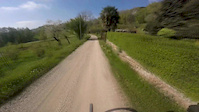
Popular Torreano Mountain Biking Trails
• 95 ★ 4.6 • 3,986 ft • 0 ft • 219 •
Trail corto ma divertente con diverse linee possibili. Ideale per collegare la parte più alta dell'area (partenza in comune con il Machete) con i vari trails che partono più in basso ( / , , Vernasso easy Dh trail, Tarci Trail). Trail...
• 100 ★ 4.4 • 1 mile • 23 ft • 213 •
Uno dei sentieri più famosi dell'Area di Torreano, flow ma allo stesso tempo tecnico in alcuni passaggi. One of the most famous trails in the Torreano area, flow but at the same time technical in some passages.
• 90 ★ 3.5 • 3,461 ft • 0 ft • 117 •
Sentiero tecnico con tratti con molte radici, in passato è stato utilizzato anche per gare DH. Con il bagnato diventa decisamente impegnativo. Technical trail with sections with many roots, in the past it was also used for DH races....
• 80 ★ 5.0 • 2,238 ft • 0 ft • 115 •
Popular red difficulty singletrack. This mountain bike primary trail can be used downhill primary and has a moderate overall physical rating with a 0 ft blue climb. On average it takes 6 minutes to complete this trail.
Videos of Torreano Mountain Bike
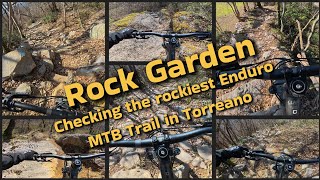
trail: Rock Garden
0:49 |
153 |
Apr 30, 2016
trail: Rock Garden
3:26 |
278 |
Feb 16, 2014
trail: Rock Garden
3:00 |
275 |
Feb 9, 2014
trail: Rock Garden
2:40 |
81 |
Mar 10, 2025 , Torreano
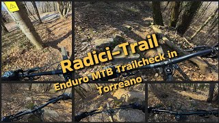
trail: Radici
3:48 |
108 |
Mar 6, 2025 , Torreano
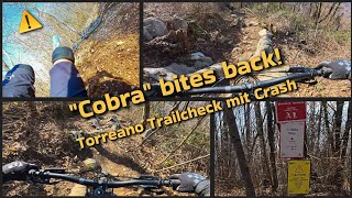
trail: Cobra
3:46 |
106 |
Mar 6, 2025 , Torreano
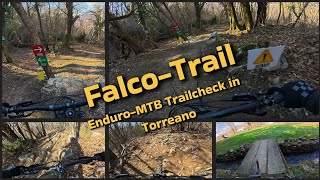
trail: Falco
9:16 |
168 |
Mar 6, 2025 , Torreano

trail: Rock Garden
7:53 |
392 |
Mar 25, 2021 , Torreano
Recent Trail Reports
| status | trail | date | condition | info | user |
|---|---|---|---|---|---|
| Cobra | Jun 18, 2026 @ 9:45pm (Europe/Rome) 16 hours | Ideal | Z9NYWs | ||
| Falco | Jun 18, 2026 @ 9:43pm (Europe/Rome) 16 hours | Ideal | Z9NYWs | ||
| Rock Garden | Apr 3, 2026 @ 2:23pm (Europe/Ljubljana) Apr 3, 2026 | Ideal | lollottanta | ||
| Radici | Apr 3, 2026 @ 2:23pm (Europe/Ljubljana) Apr 3, 2026 | Very Dry | lollottanta | ||
| Salita a Puller | Dec 13, 2025 @ 9:38am (Europe/Ljubljana) Dec 13, 2025 | Ideal | Articolo18 | ||
| Salita al Falco | Jan 28, 2024 @ 2:36am Jan 28, 2024 | Ideal | VladimirC |
Activity Feed
| username | action | type | title | date |
|---|---|---|---|---|
| Z9NYWs | add | report | activity #97270626 and 1 more | Jun 18, 2026 @ 12:43pm 16 hours |
| JosefDr2fo | ridden | trail | activity #96547230 and 1 more | Jun 8, 2026 @ 10:00am Jun 8, 2026 |
| GabrieleK1utkq | ridden | trail | activity #93834543 | May 1, 2026 @ 11:30pm May 1, 2026 |
| jacknord | ridden | trail | activity #93763774 | May 1, 2026 @ 2:27am May 1, 2026 |
| jacknord | difficultyvote | trail | activity #93763760 and 1 more | May 1, 2026 @ 2:27am May 1, 2026 |
Recent Comments
| username | type | title | comment | date |
|---|---|---|---|---|
| trail | tip top nur für erfahrene biker | Mar 22, 2026 @ 1:31am Mar 22, 2026 | ||
| trail | Very nice trail, all rideable at red level,... | Jul 4, 2025 @ 5:04am Jul 4, 2025 | ||
| trail | In 2025 – one of the worst trails in the... | Jul 4, 2025 @ 5:03am Jul 4, 2025 | ||
| trail | Amazing mix of tech and flow - best trail in... | Sep 23, 2024 @ 8:17am Sep 23, 2024 | ||
| trail | Please post as a “trail report”. This area... | Sep 16, 2024 @ 4:10am Sep 16, 2024 |
Nearby Areas
| name | distance | ||||
|---|---|---|---|---|---|
| Natisone Bike Arena (S.Pietro/Pulfero) | 2 | 6 | 2.3 km | ||
| Valle di Soffumbergo | 5 | 2.5 km | |||
| Val Chiarò | 2 | 8 | 3.3 km | ||
| Canebola | 2 | 2 | 4.2 km | ||
| Natisone Bike Arena (S.Leonardo) | 1 | 4.3 km |
Activity Type Stats
| activitytype | trails | distance | descent | descent distance | total vertical | rating | global rank | state rank | photos | reports | routes | ridelogs |
|---|---|---|---|---|---|---|---|---|---|---|---|---|
| Mountain Bike | 5 | 10 miles | 2,841 ft | 4 miles | 1,693 ft | #5,748 | #289 | 11 | 242 | 698 | ||
| E-Bike | 3 | 3 miles | 2,402 ft | 3 miles | 1,663 ft | #4,426 | #300 | 206 | 100 | |||
| Hike | 6 | 10 miles | 2,841 ft | 4 miles | 1,693 ft | #11,317 | #445 | 241 | 11 | |||
| Trail Running | 6 | 10 miles | 2,841 ft | 4 miles | 1,693 ft | #10,384 | #434 | 241 | 4 |
- By Madmork
 & contributors
 - Admins: apply
- #51100 - 1,579 views
- torreano activity log | embed map of Torreano mountain bike trails | torreano mountain biking points of interest
Downloading of trail gps tracks in kml & gpx formats is enabled for Torreano.
You must login to download files.