close
-
Layers w
- Weather Layers
- Pro
- Pro
- Pro
- Pro
- Pro
- Pro
- More Layers
- Pro
- Pro
- Pro
- Pro
-
Upgrade to

3D
Trail Conditions
- Unknown
- Snow Groomed
- Snow Packed
- Snow Covered
- Snow Cover Partial
- Freeze/thaw Cycle
- Icy
- Prevalent Mud
- Wet
- Variable
- Ideal
- Dry
- Very Dry
Trail Flow (Ridden Direction)
Trailforks scans users ridelogs to determine the most popular direction each trail is ridden. A good flowing trail network will have most trails flowing in a single direction according to their intension.
The colour categories are based on what percentage of riders are riding a trail in its intended direction.
The colour categories are based on what percentage of riders are riding a trail in its intended direction.
- > 96%
- > 90%
- > 80%
- > 70%
- > 50%
- < 50%
- bi-directional trail
- no data
Trail Last Ridden
Trailforks scans ridelogs to determine the last time a trail was ridden.
- < 2 days
- < 1 week
- < 2 weeks
- < 1 month
- < 6 months
- > 6 months
Trail Ridden Direction
The intended direction a trail should be ridden.
- Downhill Only
- Downhill Primary
- Both Directions
- Uphill Primary
- Uphill Only
- One Direction
Contribute Details
Colors indicate trail is missing specified detail.
- Description
- Photos
- Description & Photos
- Videos
Trail Popularity ?
Trailforks scans ridelogs to determine which trails are ridden the most in the last 9 months.
Trails are compared with nearby trails in the same city region with a possible 25 colour shades.
Think of this as a heatmap, more rides = more kinetic energy = warmer colors.
- most popular
- popular
- less popular
- not popular
ATV/ORV/OHV Filter
Max Vehicle Width
inches
US Cell Coverage
Legend

Radar Time
Activity Recordings
Trailforks uses anonymized public activity data.
?
Activity Recordings
Trailforks uses anonymized public activity data.
?
Personal Heatmap
▶
Activity Types
all
/
none
▶
Options
2
Date range
month
–
Winter Trails
Warning
A routing network for winter maps does not exist. Selecting trails using the winter trails layer has been disabled.
Missing Trails
Most Popular
Least Popular
Trails are colored based on popularity. The more popular a trail is, the more red. Less popular trails trend towards green.
Jump Magnitude Heatmap
Heatmap of where riders jump on trails. Zoom in to see individual jumps, click circles to view jump details.
BC Backroad Status
![map legend]()
Service Road Atlas is a free to use, community-driven service for viewing and creating reports on the numerous back-country service roads around B.C. and Alberta.

Slope Aspect
Direction the slope faces
Trails Deemphasized
Trails are shown in grey.
Only show trails with no bike usage.
Suggested Layers
Based on selected activity type
Save the current map location and zoom level as your default home location whenever this page is loaded.
Save
No description for Torrey has been added yet!
Login or register to submit one.
Activities Click to view
- Mountain Bike
80 trails
- E-Bike
29 trails
- Gravel Bike
0 trails
- Adaptive Bike
0 trails
- Horse
71 trails
- Hike
137 trails
- Trail Running
119 trails
- Dirtbike/Moto
29 trails
- ATV/ORV/OHV
29 trails
Region Details
- 20
- 1
- 7
- 37
- 12
Region Status
Caution as of Jan 19, 2026Stats
- Avg Trail Rating
- Trails (view details)
- 135
- Trails Mountain Bike
- 80
- Trails E-Bike
- 29
- Trails Horse
- 71
- Trails Hike
- 137
- Trails Trail Running
- 119
- Trails Dirtbike/Moto
- 29
- Trails ATV/ORV/OHV
- 29
- Trails Snowmobile
- 2
- Total Distance
- 478 miles
- Total Descent
- 61,703 ft
- Total Vertical
- 7,371 ft
- Highest Trailhead
- 11,302 ft
- Reports
- 87
- Photos
- 294
- Ridden Counter
- 4,777
Articles
8 Mountain Bike Trails Near Arches & Canyonlands for Beginners and Pros Alike
Feb 6, 2026 from myutahparks.com
A local’s favorite routes near these Utah national parks, plus insider riding tips, where to rent and more.
Sub Regions
-
Boulder Mountain - Boulder Top
- 2
- 1
-
Boulder Mountain-East Slope
- 2
- 17
- 4
-
Boulder Mountain-North Slope
- 2
- 3
- 1
-
Capitol Reef National Park
- 1
- 1
- 2
-
Thousand Lake Mountain
- 14
- 7
Popular Torrey Mountain Biking Trails
• 100 ★ 5.0 • 6 miles • 570 ft • 48 •
This trail follows sections of the motorized route of the Great Western Trail from Sand Creek Road west of Torrey to an overlook of the Fremont River Valley and Boulder Mountain. The climbing is gradual and would normally be rated green...
• 100 ★ 0.0 • 846 ft • 56 ft • 19 • • hike
Popular white difficulty family friendly paved path. This hike primary trail can be used both directions and has a easy overall physical rating. Trail visibility is always easy to follow. On average it takes 1 minutes to complete this trail.
• 95 ★ 0.0 • 4 miles • 852 ft • 19 •
An old ATV trail, this is more like Capitol Reef than a National Forest. Can be combined with Singletree Falls for a through trip. The lower (north end) is in BLM land, but most is in the National Forest.
• 100 ★ 0.0 • 1 mile • 4 ft • 18 • • hike
Popular green difficulty family friendly singletrack. This hike primary trail can be used both directions and has a easy overall physical rating. Trail visibility is always easy to follow.
• 85 ★ 0.0 • 10 miles • 2,481 ft • 11 •
A section of the GWT primarily intended for motorized travel, with some avenues for accessing the upper reaches of Capitol Reef National Park.
• 80 ★ 0.0 • 4,652 ft • 39 ft • 9 •
Short trail to a small but pretty waterfall, and beyond to the Slickrock Trail
• 5 ★ 4.0 • 8 miles • 664 ft • 9 •
Section of the Great Western Trail (GWT) that's decent for mountain biking. Primary trail use is ATV, which is what the trail is maintained for. Please give motorized users the right-of-way unless they indicate otherwise. I have not...
Torrey Mountain Bike Routes
38 miles • 4,265 ft • 1 • Out & Back •
Drive down the Scenic Drive in Capitol Reef National Park (pay the reasonable fee for the road), turn...
26 miles • 5,671 ft • 9 • Point to Point •
This segment of the GWT climbs over the shoulder of Thousand Lake Mountain, offering great views of...
34 miles • 6,021 ft • 8 • Point to Point •
This is the motorized route of the GWT over Thousand Lake Mountain, primarily over doubletrack with a...
6 miles • 1,336 ft • 0 •
This is adventure riding. Trails are not maintained for mountain biking and conditions are variable. You...
6 miles • 217 ft • 0 •
This is adventure riding. Trails are not maintained for mountain biking and conditions are variable. You...
73 miles • 4,162 ft • 0 • Loop •
The Cathedral Valley Loop is a great overnight bikepacking adventure through the remote and rugged...
Photos of Torrey Mountain Bike
Videos of Torrey Mountain Bike
youtuber
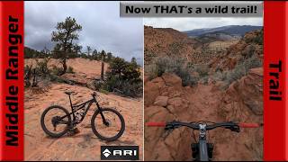
![What did I just take my bike down!? (Middle...]()

trail: Middle Ranger Trail
55:10 |
13 |
May 15, 2026 , Torrey
youtuber
![What did I just take my bike down!? (Middle...]()
trail: Little Bryce Trail
55:10 |
21 |
May 15, 2026 , Torrey
youtuber
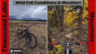
![Wild Wet Weather on Thousand Lake Mountain! |...]()

trail: Cold Springs
58:40 |
41 |
Oct 17, 2025 , Torrey

youtuber
![Wild Wet Weather on Thousand Lake Mountain! |...]()

trail: Cedar Creek (North)
58:40 |
42 |
Oct 17, 2025 , Torrey
youtuber
![Wild Wet Weather on Thousand Lake Mountain! |...]()

trail: Peavine-Thousand Lake
58:40 |
44 |
Oct 17, 2025 , Torrey
youtuber
![Wild Wet Weather on Thousand Lake Mountain! |...]()

trail: Flat Top Trail
58:40 |
38 |
Oct 17, 2025 , Torrey
youtuber
![Wild Wet Weather on Thousand Lake Mountain! |...]()
trail: Blind Lake Access
58:40 |
48 |
Oct 17, 2025 , Torrey
Recent Trail Reports
| status | trail | date | condition | info | user |
|---|---|---|---|---|---|
| Great Western Trail: Velvet Ridge Section | Jan 19, 2026 @ 8:34pm (America/Denver) Jan 19, 2026 | Very Dry | dostle01 | ||
| Rosebud Trail | May 27, 2025 @ 11:20am May 27, 2025 | Dry | JasonFarns | ||
| Slickrock Trail: Singletree to Pleasant Creek | May 27, 2025 @ 11:07am May 27, 2025 | Very Dry | JasonFarns | ||
| Singletree Falls Trail | May 24, 2025 @ 10:48am May 24, 2025 | Ideal | JasonFarns | ||
| Blind Lake Access | Jan 29, 2025 @ 8:31am Jan 29, 2025 | Unknown | Themccarthyfarm WTF | ||
| Great Western Trail: Teasdale to Pine Creek | May 30, 2023 @ 9:01am May 30, 2023 | Dry | Themccarthyfarm WTF | ||
| Hell's Hole | Sep 6, 2022 @ 9:46am Sep 6, 2022 | Dry | Carlstewart77 | ||
| Great Western Trail: Sand Creek to Sulphur Spring | Sep 6, 2022 @ 9:36am Sep 6, 2022 | Dry | Carlstewart77 | ||
| Ant Hill | May 17, 2022 @ 8:43am May 17, 2022 | Very Dry | Sharonb Cypress | ||
| South Draw: Pleasant Creek to Tantalus Flats | Apr 30, 2022 @ 11:14am Apr 30, 2022 | Dry | SenorDickey |
National Scenic Trails & Official Routes
-
Great Western Trail
- Mountain Bike
- E-Bike
- Horse
- Hike
- Trail Running
- Dirtbike/Moto
- ATV/ORV/OHV

Activity Feed
| username | action | type | title | date |
|---|---|---|---|---|
| youdse | wishlist | trail | activity #97139890 | Jun 16, 2026 @ 3:02pm 3 days |
| martysgone | wishlist | route | activity #97069393 | Jun 15, 2026 @ 3:34pm Jun 15, 2026 |
| mtnhamster | wishlist | region | activity #96722407 | Jun 11, 2026 @ 12:40am Jun 11, 2026 |
| Rkeuchel | wishlist | trail | activity #96060816 | Jun 1, 2026 @ 8:50pm Jun 1, 2026 |
| Tmax23 | wishlist | trail | activity #95594270 | May 26, 2026 @ 3:37pm May 26, 2026 |
Recent Comments
| username | type | title | comment | date |
|---|---|---|---|---|
| trail | If you do this ride, just know that there is... | Apr 20, 2026 @ 12:24pm Apr 20, 2026 | ||
| trail | Great hiking trail (I don't Mtn. Bike much... | Nov 3, 2025 @ 9:31am Nov 3, 2025 | ||
| trail | Like the other comment, this is not a blue. I... | Apr 26, 2025 @ 11:53am Apr 26, 2025 | ||
| trail | Once again, this is a pretty good adventure if... | Feb 4, 2025 @ 6:05pm Feb 4, 2025 | ||
| trail | You could put your bike in a backpack to ride... | Feb 4, 2025 @ 10:48am Feb 4, 2025 |
Local Badges
-

Epic Ride Climb 2k18 awarded -

Climbing 10k Badge1 awarded -

Climbing 100k Badge0 awarded -

Epic Ride Descent 2k18 awarded -

Descent 10k Badge1 awarded -

Descent 100k Badge0 awarded
Local Trail Supporters
- U.S. Forest Service
![]()
Activity Type Stats
| activitytype | trails | distance | descent | descent distance | total vertical | rating | global rank | state rank | photos | reports | routes | ridelogs |
|---|---|---|---|---|---|---|---|---|---|---|---|---|
| Mountain Bike | 80 | 297 miles | 38,891 ft | 121 miles | 5,909 ft | #1,115 | #430 | 222 | 83 | 8 | 963 | |
| E-Bike | 29 | 137 miles | 14,823 ft | 55 miles | 5,883 ft | #1,270 | #842 | 71 | 3 | 64 | ||
| Horse | 71 | 279 miles | 39,593 ft | 121 miles | 7,372 ft | #83 | #358 | 30 | 4 | 1 | ||
| Hike | 137 | 476 miles | 61,690 ft | 205 miles | 7,372 ft | #126 | #73 | 68 | 88 | 45 | 3,816 | |
| Trail Running | 119 | 398 miles | 53,268 ft | 176 miles | 7,372 ft | #310 | #124 | 7 | 88 | 30 | 285 | |
| Dirtbike/Moto | 29 | 127 miles | 13,120 ft | 47 miles | 5,377 ft | #267 | #133 | 20 | 2 | 13 | ||
| ATV/ORV/OHV | 29 | 127 miles | 13,120 ft | 47 miles | 5,377 ft | #151 | #66 | 20 | 2 | 7 | ||
| Snowmobile | 2 | 7 miles | 1,296 ft | 4 miles | 1,040 ft | 1 |
Frequently Asked Questions About Torrey
▼
What are the best places to ride in Torrey?
Torrey has 5 areas to explore for mountain biking. The top rated areas are:
▼
What are the highest rated mountain biking trails in Torrey?
The highest rated mountain biking trails in Torrey are:
- Behunin Creek Trail (4.1/5)
- Bare Spot (4/5)
- Great Western Trail: Teasdale to Pine Creek (4/5)
- Middle Ranger Trail (4/5)
- Rosebud Trail (3.8/5)
▼
What is the best time of the year to ride in Torrey?
Based on ride log data, the most popular months to ride in Torrey are:
- June (22 activities)
- May (19 activities)
- July (11 activities)
▼
Where can I park to ride in Torrey?
There are 44 parking locations listed in Torrey. The most popular parking spots are: View all parking and trailhead locations on the map to plan your visit.
Activities
Trails
Points of Interest
- Hickman Bridge Sight
- Beginning of slot section Sight
- Elkhorn Campground Camping
- Red Canyon Slot Sight
- Viewpoint at top of lower Meeks Mesa cliffs Sight
- Upper South Desert Viewpoint
- Temple Rock Viewpoint
- Muley Tanks Sight
- Meeks Mesa Overlook Viewpoint
- Jailhouse Rock Viewpoint
- Bluebell Knoll (11,316 ft)
- Thousand Lake Mountain (11,293 ft)
- Lookout Peak (11,132 ft)
- By Ceradini & contributors
- Admins: jkwilliamz, UtahJohn, jpmcghee, jasonmalczyk
- #23994 - 9,436 views
- torrey activity log | embed map of Torrey mountain bike trails | torrey mountain biking points of interest
Downloading of trail gps tracks in kml & gpx formats is enabled for Torrey.
You must login to download files.