close
-
Layers w
- Weather Layers
- Pro
- Pro
- Pro
- Pro
- Pro
- Pro
- More Layers
- Pro
- Pro
- Pro
- Pro
-
Upgrade to

3D
Trail Conditions
- Unknown
- Snow Groomed
- Snow Packed
- Snow Covered
- Snow Cover Partial
- Freeze/thaw Cycle
- Icy
- Prevalent Mud
- Wet
- Variable
- Ideal
- Dry
- Very Dry
Trail Flow (Ridden Direction)
Trailforks scans users ridelogs to determine the most popular direction each trail is ridden. A good flowing trail network will have most trails flowing in a single direction according to their intension.
The colour categories are based on what percentage of riders are riding a trail in its intended direction.
The colour categories are based on what percentage of riders are riding a trail in its intended direction.
- > 96%
- > 90%
- > 80%
- > 70%
- > 50%
- < 50%
- bi-directional trail
- no data
Trail Last Ridden
Trailforks scans ridelogs to determine the last time a trail was ridden.
- < 2 days
- < 1 week
- < 2 weeks
- < 1 month
- < 6 months
- > 6 months
Trail Ridden Direction
The intended direction a trail should be ridden.
- Downhill Only
- Downhill Primary
- Both Directions
- Uphill Primary
- Uphill Only
- One Direction
Contribute Details
Colors indicate trail is missing specified detail.
- Description
- Photos
- Description & Photos
- Videos
Trail Popularity ?
Trailforks scans ridelogs to determine which trails are ridden the most in the last 9 months.
Trails are compared with nearby trails in the same city region with a possible 25 colour shades.
Think of this as a heatmap, more rides = more kinetic energy = warmer colors.
- most popular
- popular
- less popular
- not popular
ATV/ORV/OHV Filter
Max Vehicle Width
inches
US Cell Coverage
Legend

Radar Time
Activity Recordings
Trailforks uses anonymized public activity data.
?
Activity Recordings
Trailforks uses anonymized public activity data.
?
Personal Heatmap
▶
Activity Types
all
/
none
▶
Options
2
Date range
month
–
Winter Trails
Warning
A routing network for winter maps does not exist. Selecting trails using the winter trails layer has been disabled.
Missing Trails
Most Popular
Least Popular
Trails are colored based on popularity. The more popular a trail is, the more red. Less popular trails trend towards green.
Jump Magnitude Heatmap
Heatmap of where riders jump on trails. Zoom in to see individual jumps, click circles to view jump details.
BC Backroad Status
![map legend]()
Service Road Atlas is a free to use, community-driven service for viewing and creating reports on the numerous back-country service roads around B.C. and Alberta.

Slope Aspect
Direction the slope faces
Trails Deemphasized
Trails are shown in grey.
Only show trails with no bike usage.
Suggested Layers
Based on selected activity type
Save the current map location and zoom level as your default home location whenever this page is loaded.
Save
No description for Toscolano has been added yet!
Login or register to submit one.
This region uses the Uk/Euro style trail grading system.
Activities Click to view
- Mountain Bike
21 trails
- E-Bike
17 trails
- Gravel Bike
0 trails
- Adaptive Bike
0 trails
- Hike
19 trails
- Trail Running
19 trails
Region Details
- 2
- 1
- 3
- 8
- 2
Region Status
Caution as of Apr 29, 2026Stats
- Avg Trail Rating
- Trails (view details)
- 19
- Trails Mountain Bike
- 21
- Trails E-Bike
- 17
- Trails Hike
- 19
- Trails Trail Running
- 19
- Total Distance
- 39 miles
- Total Descent
- 18,442 ft
- Total Vertical
- 4,850 ft
- Highest Trailhead
- 5,095 ft
- Reports
- 29
- Photos
- 14
- Ridden Counter
- 371
Popular Toscolano Mountain Biking Trails
• 100 ★ 0.0 • 2 miles • 932 ft • 50 •
Popular blue difficulty singletrack. This mountain bike primary trail can be used both directions and has a moderate overall physical rating with a 932 ft blue climb. Trail visibility is always easy to follow. On average it takes 38 minutes to complete this trail.
• 75 ★ 4.4 • 5 miles • 103 ft • 44 •
Long and spectacoular natural trail with an amazing view on the Lake. Experts only.
• 65 ★ 5.0 • 2 miles • 250 ft • 38 •
Moderately popular blue difficulty singletrack. This mountain bike primary trail can be used downhill primary and has a moderate overall physical rating with a 250 ft blue climb. Trail visibility is always easy to follow. On average it takes 30 minutes to complete this trail.
• 50 ★ 0.0 • 8 miles • 447 ft • 22 •
Moderately popular white difficulty family friendly dirt/gravel road. This mountain bike primary trail can be used both directions and has a moderate overall physical rating with a 447 ft blue climb. Trail visibility is always easy to follow. On average it takes 58 minutes to complete this trail.
• 95 ★ 1.0 • 3,622 ft • 309 ft • 11 •
Popular green difficulty singletrack. This mountain bike primary trail can be used downhill only.
• 5 ★ 4.0 • 1 mile • 110 ft • 11 •
Less popular blue difficulty singletrack. This mountain bike primary trail can be used downhill primary and has a moderate overall physical rating with a 110 ft black diamond climb. Trail visibility is sometimes hard to follow. On average it takes 18 minutes to complete this trail.
• 5 ★ 0.0 • 4,826 ft • 0 ft • 10 •
Less popular green difficulty singletrack. This mountain bike primary trail can be used downhill primary. On average it takes 7 minutes to complete this trail.
• 85 ★ 0.0 • 1 mile • 8 ft • 9 •
Popular green difficulty singletrack. This mountain bike primary trail can be used both directions.
Toscolano Mountain Bike Routes
24 miles • 6,293 ft • 0 • Loop •
Bel giro da Bogliaco lungo strade secondarie e vecchie mulattiere prima a Muslone, poi Piovere fino a Cima...
18 miles • 4,759 ft • 0 • Loop •
Very beautiful all mountain trip, developed around the Pizzoccolo peak, with a lot of points of view on...
Videos of Toscolano Mountain Bike
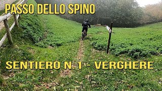
trail: Don Pablo
14:51 |
269 |
May 4, 2023 , Toscolano
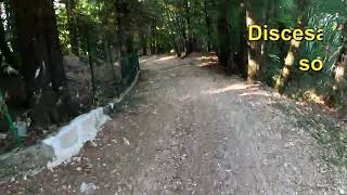
trail: Epic Trail KM Selvaggio
11:04 |
827 |
May 4, 2023 , Toscolano
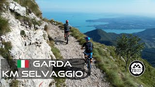
trail: Epic Trail KM Selvaggio
18:54 |
136 |
Feb 7, 2026 , Toscolano
Recent Trail Reports
| status | trail | date | condition | info | user |
|---|---|---|---|---|---|
| Spino - Monte Pizzocolo | Apr 29, 2026 @ 10:39am (Europe/Rome) Apr 29, 2026 | Unknown | WzbNoR | ||
| Strada di Sant'Urbano | Apr 18, 2026 @ 6:08pm (Europe/Rome) Apr 18, 2026 | Unknown | AndreaKTM12 | ||
| Sanico trail | Apr 18, 2026 @ 6:06pm (Europe/Rome) Apr 18, 2026 | Variable | AndreaKTM12 | ||
| Epic Trail KM Selvaggio | Dec 13, 2025 @ 6:33pm (Europe/Rome) Dec 13, 2025 | Ideal | mtbbresciafederico | ||
| Climb To Pizzocolo | Apr 25, 2025 @ 12:19pm Apr 25, 2025 | Ideal | poporni NORTHNLINE | ||
| Rio Torto | Dec 3, 2024 @ 9:53am Dec 3, 2024 | Dry | Ziobike | ||
| Camerate e Valle delle Cartiere | Sep 30, 2024 @ 12:49pm Sep 30, 2024 | Dry | RRKRK | ||
| Carta trail | Sep 11, 2024 @ 11:04am Sep 11, 2024 | Unknown | Roman1985 | ||
| Sentiero dei Ladroni | Jun 4, 2021 @ 11:42pm Jun 4, 2021 | Ideal | Jo24Jo |
Activity Feed
| username | action | type | title | date |
|---|---|---|---|---|
| Still_happy | wishlist | trail | activity #96038253 | Jun 1, 2026 @ 1:36pm Jun 1, 2026 |
| Still_happy | wishlist | trail | activity #95943552 | May 31, 2026 @ 8:34am May 31, 2026 |
| Still_happy | wishlist | trail | activity #95912765 | May 31, 2026 @ 12:11am May 31, 2026 |
| BenjaminBirk | wishlist | trail | activity #95779084 and 1 more | May 29, 2026 @ 8:24am May 29, 2026 |
| Rouven82 | wishlist | trail | activity #95585004 | May 26, 2026 @ 12:56pm May 26, 2026 |
Recent Comments
| username | type | title | comment | date |
|---|---|---|---|---|
| trail | Trail is blocked by fence at km3.5 from... | Apr 12, 2026 @ 7:08am Apr 12, 2026 | ||
| report | concordo quanto descritto | Apr 7, 2026 @ 1:35am Apr 7, 2026 | ||
| trail | I honestly don't think this should be coming... | Sep 21, 2025 @ 12:31am Sep 21, 2025 | ||
| trail | The only way to come from archesane to gaino... | Apr 17, 2025 @ 10:43pm Apr 17, 2025 | ||
| trail | Would you mind updating it with a trail... | Apr 17, 2025 @ 12:25am Apr 17, 2025 |
Local Badges
-

Epic Mountain Bike Climb 2k5 awarded -

Climbing 10k Badge0 awarded -

Mountain Biking 100k Badge0 awarded -

Epic Ride Descent 2k5 awarded -

Descent 10k Badge0 awarded -

Descent 100k Badge0 awarded
Activity Type Stats
| activitytype | trails | distance | descent | descent distance | total vertical | rating | global rank | state rank | photos | reports | routes | ridelogs |
|---|---|---|---|---|---|---|---|---|---|---|---|---|
| Mountain Bike | 21 | 39 miles | 18,442 ft | 25 miles | 4,849 ft | #4,975 | #362 | 14 | 29 | 2 | 1,111 | |
| E-Bike | 17 | 31 miles | 12,782 ft | 19 miles | 4,849 ft | #3,792 | #363 | 29 | 118 | |||
| Hike | 19 | 32 miles | 13,701 ft | 20 miles | 4,849 ft | #5,843 | #283 | 24 | 97 | |||
| Trail Running | 19 | 32 miles | 13,701 ft | 20 miles | 4,849 ft | #5,360 | #265 | 24 | 4 |
Frequently Asked Questions About Toscolano
▼
What are the highest rated mountain biking trails in Toscolano?
The highest rated mountain biking trails in Toscolano are:
- Sentiero dei Ladroni (4.1/5)
- Epic Trail KM Selvaggio (4.1/5)
- Don Pablo (4/5)
- Sanico trail (4/5)
- Selva Scura (4/5)
▼
What is the best time of the year to ride in Toscolano?
Based on ride log data, the most popular months to ride in Toscolano are:
- June (8 activities)
- July (4 activities)
- October (2 activities)
▼
Where can I park to ride in Toscolano?
Check the Toscolano trail map for trailhead and parking information. Community members regularly update access and parking details for trails in the area.
▼
What is the longest trail in Toscolano?
The longest trail in Toscolano is Camerate e Valle delle Cartiere at 7.5 miles. View all trails sorted by distance.
Activities
Trails
Points of Interest
- By NicolaB & contributors
- Admins: marcoangeletti, adessoomaipiu, micheletraversi
- #17559 - 2,766 views
- toscolano activity log | embed map of Toscolano mountain bike trails |
Downloading of trail gps tracks in kml & gpx formats is enabled for Toscolano.
You must login to download files.