close
-
Layers w
- Weather Layers
- Pro
- Pro
- Pro
- Pro
- Pro
- Pro
- More Layers
- Pro
- Pro
- Pro
- Pro
-
Upgrade to

3D
Trail Conditions
- Unknown
- Snow Groomed
- Snow Packed
- Snow Covered
- Snow Cover Partial
- Freeze/thaw Cycle
- Icy
- Prevalent Mud
- Wet
- Variable
- Ideal
- Dry
- Very Dry
Trail Flow (Ridden Direction)
Trailforks scans users ridelogs to determine the most popular direction each trail is ridden. A good flowing trail network will have most trails flowing in a single direction according to their intension.
The colour categories are based on what percentage of riders are riding a trail in its intended direction.
The colour categories are based on what percentage of riders are riding a trail in its intended direction.
- > 96%
- > 90%
- > 80%
- > 70%
- > 50%
- < 50%
- bi-directional trail
- no data
Trail Last Ridden
Trailforks scans ridelogs to determine the last time a trail was ridden.
- < 2 days
- < 1 week
- < 2 weeks
- < 1 month
- < 6 months
- > 6 months
Trail Ridden Direction
The intended direction a trail should be ridden.
- Downhill Only
- Downhill Primary
- Both Directions
- Uphill Primary
- Uphill Only
- One Direction
Contribute Details
Colors indicate trail is missing specified detail.
- Description
- Photos
- Description & Photos
- Videos
Trail Popularity ?
Trailforks scans ridelogs to determine which trails are ridden the most in the last 9 months.
Trails are compared with nearby trails in the same city region with a possible 25 colour shades.
Think of this as a heatmap, more rides = more kinetic energy = warmer colors.
- most popular
- popular
- less popular
- not popular
ATV/ORV/OHV Filter
Max Vehicle Width
inches
US Cell Coverage
Legend

Radar Time
Activity Recordings
Trailforks uses anonymized public activity data.
?
Activity Recordings
Trailforks uses anonymized public activity data.
?
Personal Heatmap
▶
Activity Types
all
/
none
▶
Options
2
Date range
month
–
Winter Trails
Warning
A routing network for winter maps does not exist. Selecting trails using the winter trails layer has been disabled.
Missing Trails
Most Popular
Least Popular
Trails are colored based on popularity. The more popular a trail is, the more red. Less popular trails trend towards green.
Jump Magnitude Heatmap
Heatmap of where riders jump on trails. Zoom in to see individual jumps, click circles to view jump details.
BC Backroad Status
![map legend]()
Service Road Atlas is a free to use, community-driven service for viewing and creating reports on the numerous back-country service roads around B.C. and Alberta.

Slope Aspect
Direction the slope faces
Trails Deemphasized
Trails are shown in grey.
Only show trails with no bike usage.
Suggested Layers
Based on selected activity type
Save the current map location and zoom level as your default home location whenever this page is loaded.
Save
No description for Trailside Park has been added yet!
Login or register to submit one.
 google parking directions

google parking directionsLinks
IMBA Ride Center
Park City
Activities Click to view
- Mountain Bike
39 trails
- Hike
16 trails
- Trail Running
16 trails
Bike Park Details
- 3
- 3
- 18
- 10
- 3
Region Status
Open as of 1 dayStats
- Avg Trail Rating
- Trails (view details)
- 39
- Trails Mountain Bike
- 40
- Trails Horse
- 3
- Trails Hike
- 16
- Trails Trail Running
- 16
- Trails Snowmobile
- 1
- Trails Snowshoe
- 1
- Trails Nordic Ski
- 2
- Total Distance
- 17 miles
- Total Descent
- 1,846 ft
- Total Vertical
- 454 ft
- Highest Trailhead
- 6,875 ft
- Reports
- 940
- Photos
- 182
- Ridden Counter
- 36,464
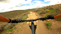
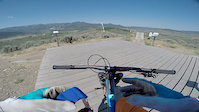
Popular Trailside Park Mountain Biking Trails
• 100 ★ 2.7 • 1,096 ft • 67 ft • 2,765 •
Wide singletrack that takes you to the slopestyle and technical trails at Trailside Bike Park.
• 100 ★ 3.3 • 535 ft • 3 ft • 2,650 •
Easy little trail that you can use to drop off and get to the Pump Track. The Pump Track is technically named along with all the connector trails.
• 95 ★ 4.2 • 1,355 ft • 0 ft • 2,556 •
Easiest flow trail at Trailside. Lots of berms and a few very small jumps that can be rolled if you don't have the speed or inclination to launch over them. Non-intimidating for new riders, but more experienced types can just ride it...
• 95 ★ 4.5 • 2,487 ft • 4 ft • 2,465 •
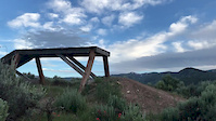
Fun DH, short but sweet with great features. Most the trail is dirt double ups and a big wood berm. There are 2 wall rides right at the end, not easy to hit them both cleanly, best to pick one and go hard.
• 5 ★ 4.4 • 597 ft • 0 ft • 2,462 •
This is a short straight run with 4 evenly spaced flat top jumps. There are two tracks side by side with smaller jumps on the right and a bit larger on the left. It is a good place to learn or just get comfortable jumping your bike.
• 100 ★ 3.5 • 679 ft • 5 ft • 2,353 •
This a small loop that is part of the practice area. Build up your skills by choosing the more difficult lines. A couple different tracks provide a skinny with a small drop or a small ramp to the left.
• 85 ★ 4.6 • 2,461 ft • 51 ft • 1,880 •
Fun flow trail with a few berms and jumps, and lots of wooden bridges mixed with some technical rock features. There are a couple turns that are basically deep embedded rocks. The toughest rock garden has a ride-around. Probably not...
Trailside Park Mountain Bike Routes
11 miles • 957 ft • 9 • Loop •
This is an 11 mile loop of moderate trails in the round valley area. All skill levels should be able to...
6 miles • 781 ft • 7 • Point to Point •
The full Rambler trail from Old Ranch Road to Quinns Junction. It is one of the older trails in the Round...
7 miles • 737 ft • 6 • Loop •
This route starts and stops in , but encompasses some of the trails on the north end of Round Valley. Most...
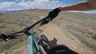
Photos of Trailside Park Mountain Bike
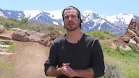
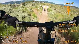
Videos of Trailside Park Mountain Bike
trail: Mr Muchrocks
0:10 |
610 |
May 16, 2020
trail: Bamm Bamm
0:05 |
464 |
Oct 18, 2019
trail: Bronto Jam
2:43 |
483 |
Nov 6, 2017
trail: Bamm Bamm
0:38 |
829 |
Jul 10, 2017
trail: Bamm Bamm
0:54 |
114 |
May 27, 2025 , Park City
trail: Bamm Bamm
0:17 |
207 |
Jun 24, 2024 , Park City
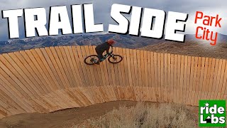
youtuber
![Trailside Park, Park City]()

17:03 |
404 |
Nov 11, 2020
Recent Trail Reports
| status | trail | date | condition | info | user |
|---|---|---|---|---|---|
| TSP Climb | Jun 19, 2026 @ 8:53am (America/Boise) 1 day | Dry | fletchridesagain | ||
| Trailside Park | Jun 19, 2026 @ 8:53am (America/Boise) 1 day | Dry | fletchridesagain | ||
| Trailside Park West | Jun 19, 2026 @ 8:53am (America/Boise) 1 day | Dry | fletchridesagain | ||
| Bedrock Skills Area | Jun 19, 2026 @ 8:53am (America/Boise) 1 day | Dry | fletchridesagain | ||
| Hailles Return | Jun 19, 2026 @ 8:53am (America/Boise) 1 day | Dry | fletchridesagain | ||
| Mr Muchrocks | Jun 19, 2026 @ 8:53am (America/Boise) 1 day | Dry | fletchridesagain | ||
| Unga Bunga | Jun 19, 2026 @ 8:53am (America/Boise) 1 day | Dry | fletchridesagain | ||
| Bamm Bamm | Jun 19, 2026 @ 8:53am (America/Boise) 1 day | Dry | fletchridesagain | ||
| Bedrock Skills Loop | Jun 19, 2026 @ 8:53am (America/Boise) 1 day | Dry | fletchridesagain | ||
| The Tar Pits | Jun 19, 2026 @ 8:53am (America/Boise) 1 day | Ideal | fletchridesagain |
Activity Feed
| username | action | type | title | date |
|---|---|---|---|---|
| jtran005 | wishlist | region | activity #97366727 | Jun 19, 2026 @ 10:18pm 15 hours |
| fletchridesagain | add | report | activity #97330206 and 10 more | Jun 19, 2026 @ 10:51am 1 day |
| kyjensen | add | report | activity #97312662 and 4 more | Jun 19, 2026 @ 6:31am 1 day |
| Tribigsky | wishlist | route | activity #97197535 | Jun 17, 2026 @ 11:14am Jun 17, 2026 |
| chrisj01 | wishlist | trail | activity #96754314 | Jun 11, 2026 @ 12:10pm Jun 11, 2026 |
Recent Comments
| username | type | title | comment | date |
|---|---|---|---|---|
| trail | Fun but there are some slippery parts | Jan 5, 2026 @ 4:54pm Jan 5, 2026 | ||
| trail | Good trail for beginners | Jan 5, 2026 @ 4:53pm Jan 5, 2026 | ||
| trail | East half is closed for reconstruction | Jul 29, 2025 @ 4:59am Jul 29, 2025 | ||
| trail | This is my favorite trail in northern UT. ... | May 26, 2025 @ 12:59pm May 26, 2025 | ||
| trail | Fun but a couple features don't really make... | May 2, 2025 @ 6:55am May 2, 2025 |
Nearby Areas
| name | distance | ||||
|---|---|---|---|---|---|
| Willow Creek Trails | 3 | 1.8 km | |||
| Round Valley | 25 | 30 | 4 | 2.1 km | |
| Utah Olympic Park | 7 | 16 | 3 | 2.9 km | |
| Glenwild | 1 | 21 | 2 | 3.1 km | |
| Promontory | 3 | 3.9 km |
Local Badges
-

Completionist2 awarded
Bike & Skill Parks
| name | type | city | rating |
|---|---|---|---|
| Trailside Park | skill park | Park City |
Upcoming Local Events
Local Products
Local Products
Activity Type Stats
| activitytype | trails | distance | descent | descent distance | total vertical | rating | global rank | state rank | photos | reports | routes | ridelogs |
|---|---|---|---|---|---|---|---|---|---|---|---|---|
| Mountain Bike | 39 | 16 miles | 1,804 ft | 7 miles | 453 ft | #535 | #201 | 195 | 940 | 11 | 9,149 | |
| Horse | 3 | 4 miles | 361 ft | 2 miles | 397 ft | 182 | ||||||
| Hike | 16 | 10 miles | 866 ft | 4 miles | 453 ft | #8,412 | #3,157 | 868 | 561 | |||
| Trail Running | 16 | 10 miles | 866 ft | 4 miles | 453 ft | #6,937 | #2,267 | 868 | 1 | 1,005 | ||
| Snowmobile | 1 | 3,310 ft | 213 ft | 3,064 ft | 217 ft | 2 | ||||||
| Snowshoe | 1 | 2 miles | 98 ft | 4,715 ft | 151 ft | 18 | 4 | |||||
| Nordic Ski | 2 | 1 mile | 39 ft | 2,126 ft | 43 ft | 2 | 67 |
Frequently Asked Questions About Trailside Park
▼
What are the highest rated mountain biking trails in Trailside Park?
The highest rated mountain biking trails in Trailside Park are:
- Mr Muchrocks (4.5/5)
- Bronto Jam (4.4/5)
- Bamm Bamm (4.3/5)
- The Tar Pits (4.2/5)
- Yabba Dabba Doo (4.2/5)
▼
What is the best time of the year to ride in Trailside Park?
Based on ride log data, the most popular months to ride in Trailside Park are:
- July (204 activities)
- June (136 activities)
- August (111 activities)
▼
Where can I park to ride in Trailside Park?
There are 2 parking locations listed in Trailside Park. The most popular parking spots are:
▼
What is the longest trail in Trailside Park?
The longest trail in Trailside Park is Happy Gilmor at 2.0 miles. View all trails sorted by distance.
Activities
Trails
- By todd
 Trailforks & contributors
 - Admins: MTF, NAC, todd
- #4811 - 18,732 views
- trailside park activity log | embed map of Trailside Park mountain bike trails | trailside park mountain biking points of interest
Downloading of trail gps tracks in kml & gpx formats is enabled for Trailside Park.
You must login to download files.