close
-
Layers w
- Weather Layers
- Pro
- Pro
- Pro
- Pro
- Pro
- Pro
- More Layers
- Pro
- Pro
- Pro
- Pro
-
Upgrade to

3D
Trail Conditions
- Unknown
- Snow Groomed
- Snow Packed
- Snow Covered
- Snow Cover Partial
- Freeze/thaw Cycle
- Icy
- Prevalent Mud
- Wet
- Variable
- Ideal
- Dry
- Very Dry
Trail Flow (Ridden Direction)
Trailforks scans users ridelogs to determine the most popular direction each trail is ridden. A good flowing trail network will have most trails flowing in a single direction according to their intension.
The colour categories are based on what percentage of riders are riding a trail in its intended direction.
The colour categories are based on what percentage of riders are riding a trail in its intended direction.
- > 96%
- > 90%
- > 80%
- > 70%
- > 50%
- < 50%
- bi-directional trail
- no data
Trail Last Ridden
Trailforks scans ridelogs to determine the last time a trail was ridden.
- < 2 days
- < 1 week
- < 2 weeks
- < 1 month
- < 6 months
- > 6 months
Trail Ridden Direction
The intended direction a trail should be ridden.
- Downhill Only
- Downhill Primary
- Both Directions
- Uphill Primary
- Uphill Only
- One Direction
Contribute Details
Colors indicate trail is missing specified detail.
- Description
- Photos
- Description & Photos
- Videos
Trail Popularity ?
Trailforks scans ridelogs to determine which trails are ridden the most in the last 9 months.
Trails are compared with nearby trails in the same city region with a possible 25 colour shades.
Think of this as a heatmap, more rides = more kinetic energy = warmer colors.
- most popular
- popular
- less popular
- not popular
ATV/ORV/OHV Filter
Max Vehicle Width
inches
US Cell Coverage
Legend

Radar Time
Activity Recordings
Trailforks uses anonymized public activity data.
?
Activity Recordings
Trailforks uses anonymized public activity data.
?
Personal Heatmap
▶
Activity Types
all
/
none
▶
Options
2
Date range
month
–
Winter Trails
Warning
A routing network for winter maps does not exist. Selecting trails using the winter trails layer has been disabled.
Missing Trails
Most Popular
Least Popular
Trails are colored based on popularity. The more popular a trail is, the more red. Less popular trails trend towards green.
Jump Magnitude Heatmap
Heatmap of where riders jump on trails. Zoom in to see individual jumps, click circles to view jump details.
BC Backroad Status
![map legend]()
Service Road Atlas is a free to use, community-driven service for viewing and creating reports on the numerous back-country service roads around B.C. and Alberta.

Slope Aspect
Direction the slope faces
Trails Deemphasized
Trails are shown in grey.
Only show trails with no bike usage.
Suggested Layers
Based on selected activity type
Save the current map location and zoom level as your default home location whenever this page is loaded.
SaveTrebević (Serbian Cyrillic: Требевић) is a mountain in central Bosnia and Herzegovina, located to the southeast of Sarajevo, in the territory of East Sarajevo city, bordering Jahorina mountain. Trebević is 1,627 meters (5,338 ft) tall, making it the second shortest of the Sarajevo mountains.
During the Middle Ages, Trebević was known as Zlatni Do.[citation needed] During the 1984 Winter Olympics Trebević, like the other Sarajevo mountains, was used for a number of Olympic events, such as bobsledding.
Trebević today is important as a tourist destination for citizens of Sarajevo as Igman or Bjelašnica.[citation needed] Most of the land mines are now cleared from heavy fighting that took place in the early 1990s. There are a few hotels, mountaineering homes, and other such structures on Trebević and the immediate area. The mountain is very popular for family picnics, hiking, climbing, mountain biking and it has a downhill track for local and international skiing competitions.[3]
Trebević has been the main excursion site for Sarajevo citizens due to the favorable geographical position, climate and the beauty of the nature. The biological diversity is among the highest and it is extraordinary to find such a phenomenon near the heart of the big city.[citation needed] On 9 April 2014, Sarajevo Canton Assembly declared Trebević a protected area, in order to conserve and improve each element of the geographical and biological diversity.[4]
Trebević can be reached from Sarajevo by the Trebević Cable Car, which starts from the neighbourhood of Bistrik
Primary Trail Type: All-Mountain & Downhill
Shuttleable: YES
Land Status: City Managed
 google parking directions
 Activities Click to view
- Mountain Bike
31 trails
- E-Bike
32 trails
- Horse
10 trails
- Hike
27 trails
- Trail Running
31 trails
- Dirtbike/Moto
9 trails
- ATV/ORV/OHV
10 trails
Region Details
- 6
- 9
- 13
- 3
Region Status
Caution as of Jun 10, 2026Stats
- Avg Trail Rating
- Trails (view details)
- 36
- Trails Mountain Bike
- 31
- Trails E-Bike
- 32
- Trails Gravel Bike
- 1
- Trails Horse
- 10
- Trails Hike
- 27
- Trails Trail Running
- 31
- Trails Dirtbike/Moto
- 9
- Trails Observed Trials
- 3
- Trails ATV/ORV/OHV
- 10
- Trails Nordic Ski
- 1
- Total Distance
- 34 miles
- Total Descent
- 11,586 ft
- Total Vertical
- 3,026 ft
- Highest Trailhead
- 5,291 ft
- Reports
- 52
- Photos
- 30
- Ridden Counter
- 406
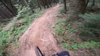
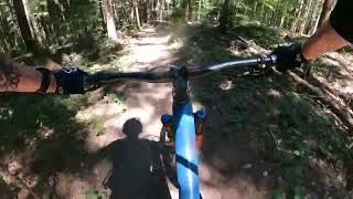
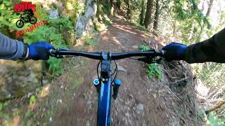
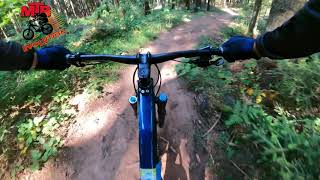
Popular Trebevic Mountain Biking Trails
• 85 ★ 5.0 • 2,756 ft • 29 ft • 27 •
Popular blue difficulty singletrack. This mountain bike primary trail can be used downhill primary and has a easy overall physical rating with a 29 ft black diamond climb. Trail visibility is always easy to follow. On average it takes 8 minutes to complete this trail.
• 70 ★ 5.0 • 4,705 ft • 0 ft • 21 •
Popular black diamond difficulty singletrack. This mountain bike primary trail can be used downhill primary and has a hard overall physical rating with a 0 ft black diamond climb. Trail visibility is always easy to follow. On average it takes 6 minutes to complete this trail.
• 85 ★ 5.0 • 4,613 ft • 0 ft • 21 •
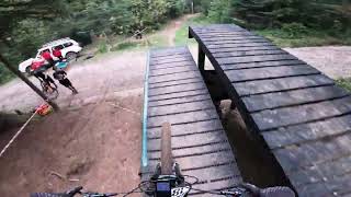
Popular blue difficulty singletrack. This mountain bike primary trail can be used downhill primary and has a moderate overall physical rating with a 0 ft green climb. It features berm, bridge, drop and skinny. Trail visibility is always easy to follow. On average it takes 8 minutes to complete this trail.
• 100 ★ 5.0 • 2 miles • 13 ft • 18 •
Popular blue difficulty singletrack. This multi-use trail can be used downhill primary and has a moderate overall physical rating with a 13 ft blue climb. It features drop, rock face and skinny. Trail visibility is always easy to follow. On average it takes 15 minutes to complete this trail.
• 40 ★ 4.0 • 2,963 ft • 0 ft • 14 •
Moderately popular blue difficulty singletrack. This multi-use trail can be used downhill primary and has a moderate overall physical rating with a 0 ft blue climb. It features rock garden. Trail visibility is sometimes hard to follow. On average it takes 3 minutes to complete this trail.
• 95 ★ 5.0 • 741 ft • 105 ft • 12 • • hike
Popular blue difficulty singletrack. This hike primary trail can be used both directions and has a easy overall physical rating. Trail visibility is always easy to follow. On average it takes 2 minutes to complete this trail.
• 100 ★ 0.0 • 6 miles • 1,019 ft • 11 •
Ćirina pruga je jedna od najatraktivnijih biciklističkih ruta u okolini Sarajeva. Ova staza prati nekadašnju uskotračnu željezničku prugu koja je povezivala Sarajevo i Pale, pružajući jedinstvenu kombinaciju prirodnih ljepota,...
• 70 ★ 2.0 • 3,018 ft • 10 ft • 10 •
Popular blue difficulty singletrack. This mountain bike primary trail can be used downhill primary and has a moderate overall physical rating. Trail visibility is always easy to follow. On average it takes 9 minutes to complete this trail.
Trebevic Mountain Bike Routes
8 miles • 479 ft • 2 •
Giro Di Ciro Sarajevo: The Newly Opened Cycling Route to Pale Bosnia and Herzegovina has just gained...
14 miles • 2,156 ft • 7 •
Eduro ruta koji obuhvata 4 staze na planini Trebevic
★ 5.0 • 16 miles • 2,058 ft • 0 •
Kalinovik govza-orlovacko jezero
32 miles • 3,492 ft • 0 • Loop •
This marathon route is a perfect combination of physical challenge and historical tourism. We start from...
21 miles • 3,140 ft • 0 • Loop •
Voznja atrakrivnom Bob Stazom na Trebevicu a ona Cirina pruga Sarajevo -Pale
Photos of Trebevic Mountain Bike
Videos of Trebevic Mountain Bike
trail: Trebevic Enduro
3:29 |
86 |
May 22, 2025 , East Sarajevo
trail: Treba DH
4:08 |
265 |
Oct 3, 2024 , East Sarajevo

trail: Three Fools DH
0:55 |
261 |
Oct 23, 2022 , East Sarajevo
trail: Trebevic Enduro
4:04 |
311 |
May 22, 2022 , East Sarajevo
trail: Princeza
7:13 |
311 |
Nov 6, 2021 , East Sarajevo
trail: Trebevic Enduro
3:55 |
225 |
Nov 6, 2021 , East Sarajevo
trail: Napoleon
6:14 |
497 |
Jun 21, 2020 , East Sarajevo

trail: Three Fools DH
4:41 |
557 |
May 26, 2020 , East Sarajevo
Recent Trail Reports
| status | trail | date | condition | info | user |
|---|---|---|---|---|---|
| Dobre Vode - Three Fools | Jun 20, 2025 @ 10:06am Jun 20, 2025 | Dry | PMSAF | ||
| Three Fools DH | Jun 20, 2025 @ 10:05am Jun 20, 2025 | Dry | PMSAF | ||
| Trebevic Enduro | Sep 29, 2024 @ 11:35am Sep 29, 2024 | Wet | LakhovAndrey SERBIA | ||
| Dobre vode road | Sep 29, 2024 @ 11:35am Sep 29, 2024 | Wet | LakhovAndrey SERBIA | ||
| Princeza trail | Sep 18, 2023 @ 6:06am Sep 18, 2023 | Variable | grimurd | ||
| Educational trail | Jul 10, 2023 @ 3:59am Jul 10, 2023 | Dry | AdixProzz | ||
| Princeza | May 20, 2023 @ 1:09am May 20, 2023 | Variable | marko-ristivojevic-evolution MTB Evolution | ||
| Petruse | Dec 31, 2022 @ 7:50pm Dec 31, 2022 | Ideal | marko-ristivojevic-evolution MTB Evolution | ||
| Napoleon | Dec 31, 2022 @ 7:50pm Dec 31, 2022 | Variable | marko-ristivojevic-evolution MTB Evolution | ||
| Napoleon | Dec 31, 2022 @ 7:50pm Dec 31, 2022 | Variable | marko-ristivojevic-evolution MTB Evolution |
Activity Feed
| username | action | type | title | date |
|---|---|---|---|---|
| marko-ristivojevic-evolution | update | route | activity #96656158 | Jun 9, 2026 @ 11:51pm Jun 9, 2026 |
| marko-ristivojevic-evolution | add | photo | activity #96654376 | Jun 9, 2026 @ 10:38pm Jun 9, 2026 |
| marko-ristivojevic-evolution | add | route | activity #96654053 | Jun 9, 2026 @ 10:26pm Jun 9, 2026 |
| marko-ristivojevic-evolution | add | trail | activity #94789976 | May 15, 2026 @ 10:11pm May 15, 2026 |
| KemallG5bK8 | wishlist | region | activity #94408153 | May 10, 2026 @ 2:55am May 10, 2026 |
Recent Comments
| username | type | title | comment | date |
|---|---|---|---|---|
| trail | nice, not too narrow but steep beside and... | Jun 7, 2025 @ 1:15pm Jun 7, 2025 | ||
| trail | fast no turns, a lot of roots awesome :) | Jun 7, 2025 @ 1:10pm Jun 7, 2025 | ||
| trail | nice flowy trail but the grass and bushes need... | Jun 7, 2025 @ 1:04pm Jun 7, 2025 | ||
| trail | Trail is ok but it looks like a hiking trail. | Jun 14, 2024 @ 10:04am Jun 14, 2024 | ||
| trail | Unfortunately, trail is in a bad condition. | Jun 14, 2024 @ 9:58am Jun 14, 2024 |
Nearby Areas
| name | distance | ||||
|---|---|---|---|---|---|
| East Sarajevo trails | 6 | 1 | 2.4 km | ||
| Bike Park Evolution | 11 | 2 | 4 | 4.3 km | |
| Bukovik | 9 | 1 | 6 km | ||
| Jahorina | 7 | 1 | 9.1 km | ||
| Igman | 21 | 9 | 1 | 10.2 km |
Local Badges
-

Completionist0 awarded
Activity Type Stats
| activitytype | trails | distance | descent | descent distance | total vertical | rating | global rank | state rank | photos | reports | routes | ridelogs |
|---|---|---|---|---|---|---|---|---|---|---|---|---|
| Mountain Bike | 31 | 25 miles | 11,093 ft | 19 miles | 3,002 ft | #1,342 | #3 | 30 | 52 | 8 | 578 | |
| E-Bike | 32 | 31 miles | 9,734 ft | 18 miles | 3,025 ft | #869 | #3 | 46 | 3 | 18 | ||
| Gravel Bike | 1 | #2,436 | #1 | 3 | 1 | |||||||
| Horse | 10 | 11 miles | 2,448 ft | 6 miles | 2,444 ft | #245 | #3 | 1 | ||||
| Hike | 27 | 27 miles | 8,363 ft | 15 miles | 3,025 ft | #1,340 | #3 | 49 | 107 | |||
| Trail Running | 31 | 31 miles | 10,423 ft | 18 miles | 3,025 ft | #737 | #2 | 52 | 1 | 45 | ||
| Dirtbike/Moto | 9 | 10 miles | 2,326 ft | 6 miles | 2,444 ft | #237 | #4 | |||||
| Observed Trials | 3 | 2 miles | 463 ft | 1 mile | 2,444 ft | |||||||
| ATV/ORV/OHV | 10 | 11 miles | 2,382 ft | 6 miles | 2,444 ft | #139 | #4 | |||||
| Nordic Ski | 1 | 4,380 ft | 338 ft | 3,169 ft | 335 ft |
Frequently Asked Questions About Trebevic
▼
What are the highest rated mountain biking trails in Trebevic?
The highest rated mountain biking trails in Trebevic are:
- Treba DH (4.2/5)
- Dobre Vode - Three Fools (4.2/5)
- Three Fools DH (4.2/5)
- Kumane-Petrovici (4.2/5)
- Dovlići - Udež (4.1/5)
▼
What is the best time of the year to ride in Trebevic?
Based on ride log data, the most popular months to ride in Trebevic are:
- July (7 activities)
- November (6 activities)
- June (5 activities)
▼
Where can I park to ride in Trebevic?
There are 1 parking locations listed in Trebevic. The most popular parking spots are:
▼
What is the longest trail in Trebevic?
The longest trail in Trebevic is Ćirina pruga Sarajevo - Pale at 10.2 km. View all trails sorted by distance.
Activities
Trails
Points of Interest
- By marko-ristivojevic-evolution
 MTB Evolution PD Trebevic & contributors
 - Admins: PD Trebevic
- #7474 - 8,724 views
- trebevic activity log | embed map of Trebevic mountain bike trails | trebevic mountain biking points of interest
Downloading of trail gps tracks in kml & gpx formats is disabled for Trebevic.