close
-
Layers w
- Weather Layers
- Pro
- Pro
- Pro
- Pro
- Pro
- Pro
- More Layers
- Pro
- Pro
- Pro
- Pro
-
Upgrade to

3D
Trail Conditions
- Unknown
- Snow Groomed
- Snow Packed
- Snow Covered
- Snow Cover Partial
- Freeze/thaw Cycle
- Icy
- Prevalent Mud
- Wet
- Variable
- Ideal
- Dry
- Very Dry
Trail Flow (Ridden Direction)
Trailforks scans users ridelogs to determine the most popular direction each trail is ridden. A good flowing trail network will have most trails flowing in a single direction according to their intension.
The colour categories are based on what percentage of riders are riding a trail in its intended direction.
The colour categories are based on what percentage of riders are riding a trail in its intended direction.
- > 96%
- > 90%
- > 80%
- > 70%
- > 50%
- < 50%
- bi-directional trail
- no data
Trail Last Ridden
Trailforks scans ridelogs to determine the last time a trail was ridden.
- < 2 days
- < 1 week
- < 2 weeks
- < 1 month
- < 6 months
- > 6 months
Trail Ridden Direction
The intended direction a trail should be ridden.
- Downhill Only
- Downhill Primary
- Both Directions
- Uphill Primary
- Uphill Only
- One Direction
Contribute Details
Colors indicate trail is missing specified detail.
- Description
- Photos
- Description & Photos
- Videos
Trail Popularity ?
Trailforks scans ridelogs to determine which trails are ridden the most in the last 9 months.
Trails are compared with nearby trails in the same city region with a possible 25 colour shades.
Think of this as a heatmap, more rides = more kinetic energy = warmer colors.
- most popular
- popular
- less popular
- not popular
ATV/ORV/OHV Filter
Max Vehicle Width
inches
US Cell Coverage
Legend

Radar Time
Activity Recordings
Trailforks uses anonymized public activity data.
?
Activity Recordings
Trailforks uses anonymized public activity data.
?
Personal Heatmap
▶
Activity Types
all
/
none
▶
Options
2
Date range
month
–
Winter Trails
Warning
A routing network for winter maps does not exist. Selecting trails using the winter trails layer has been disabled.
Missing Trails
Most Popular
Least Popular
Trails are colored based on popularity. The more popular a trail is, the more red. Less popular trails trend towards green.
Jump Magnitude Heatmap
Heatmap of where riders jump on trails. Zoom in to see individual jumps, click circles to view jump details.
BC Backroad Status
![map legend]()
Service Road Atlas is a free to use, community-driven service for viewing and creating reports on the numerous back-country service roads around B.C. and Alberta.

Slope Aspect
Direction the slope faces
Trails Deemphasized
Trails are shown in grey.
Only show trails with no bike usage.
Suggested Layers
Based on selected activity type
Save the current map location and zoom level as your default home location whenever this page is loaded.
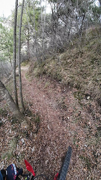
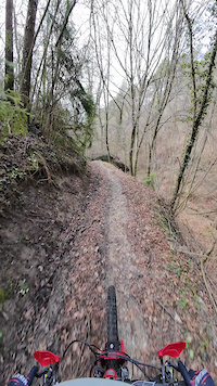
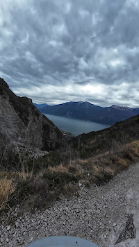
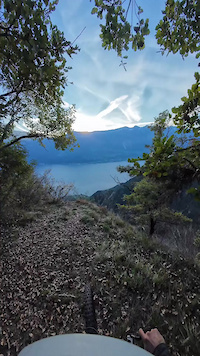
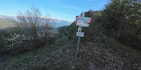
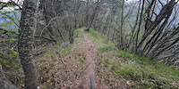
SaveTremosine is a little town in the mountains above the west coast of lake Garda, at the bottom of infamous Monte Tremalzo. The trail network is huge, reaching from 2000 m down to the lake.
Primary Trail Type: All-Mountain & Downhill
eBikes Allowed:
Yes
Shuttleable: YES
Land Status: National Park
Links
This region uses the Uk/Euro style trail grading system.
Activities Click to view
- Mountain Bike
84 trails
- E-Bike
84 trails
- Gravel Bike
1 trails
- Adaptive Bike
0 trails
- Winter Fat Bike
0 trails
- Hike
84 trails
- Trail Running
83 trails
Region Details
- 11
- 2
- 14
- 26
- 5
Region Status
Open as of Jun 8, 2026Stats
- Avg Trail Rating
- Trails (view details)
- 82
- Trails Mountain Bike
- 84
- Trails E-Bike
- 84
- Trails Gravel Bike
- 1
- Trails Hike
- 84
- Trails Trail Running
- 83
- Total Distance
- 98 miles
- Total Descent
- 64,047 ft
- Total Vertical
- 5,365 ft
- Highest Trailhead
- 6,028 ft
- Reports
- 248
- Photos
- 250
- Ridden Counter
- 3,466
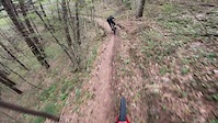
Popular Tremosine Mountain Biking Trails
• 95 ★ 4.7 • 2 miles • 137 ft • 135 •
Fast, flow turns up top, becomes more technical at the bottom. A few technical sections.
• 85 ★ 4.3 • 1 mile • 56 ft • 126 •
Fast, technical singletrail. Loose, rocky terrain. Rock faces. Some highly technical sections in between, where hike-a-bike might be necessary. High exposure in places; don't fall!
• 95 ★ 4.5 • 4 miles • 1,495 ft • 109 •
High alpine, very exposed trail. Amazing views all the way. Many other trails, on both sides of the mountain, are only reachable by this trail.
• 80 ★ 4.8 • 2 miles • 971 ft • 104 •
Very technical single trail with loose, gravelly ground. Long and physical. Very exposed and quite dangerous. Perfectly combinable with " " to reach Limone Sul Garda.
• 85 ★ 3.5 • 3 miles • 333 ft • 73 •
Fast, flowy single track up top with some technical sections. Gets wider towards the bottom.
• 90 ★ 4.0 • 3 miles • 375 ft • 69 •
Long and quite technical trail down from the well-know "Passo Di Tremalzo". Loose, gravelly surface. A few river crossings.
• 65 ★ 3.3 • 2,694 ft • 36 ft • 48 •
Steep single trail, check your brakes. Loose, rocky surface. A few switchbacks.
• 80 ★ 4.4 • 1 mile • 24 ft • 45 •
Very technical trail. Slow, tight and rocky, becomes more open at the bottom.
Photos of Tremosine Mountain Bike
Videos of Tremosine Mountain Bike
trail: Bestone Nord
2:17 |
42 |
Mar 29, 2025
trail: Via Del Maroc
0:32 |
37 |
Mar 29, 2025
trail: Valle Di Pura
8:04 |
78 |
Mar 29, 2025
trail: DALCO
15:30 |
88 |
Nov 6, 2024
6:16 |
66 |
May 1, 2024
trail: Clemone
8:36 |
67 |
Apr 30, 2024
trail: Puria DH
7:34 |
74 |
Jul 4, 2022
trail: Capanno Fornaci
0:11 |
105 |
Jul 4, 2022
Current Trail Warnings
| status | trail | date | condition | user | info |
|---|---|---|---|---|---|
| Nalbò | Jun 8, 2026 @ 4:55pm (Europe/Rome) Jun 8, 2026 | Variable | Alexxx1 | abandoned trail. overgrown trees. no fun | |
| Valle delle Pile | Jun 8, 2026 @ 1:07pm (Europe/Rome) Jun 8, 2026 | Variable | Alexxx1 | lots of vegetation. no one uses it. 8... |
Recent Trail Reports
| status | trail | date | condition | info | user |
|---|---|---|---|---|---|
| Tremalzo | May 26, 2026 @ 9:31am (Europe/Vaduz) May 26, 2026 | Variable | LarsN | ||
| Valle Di Pura | May 24, 2026 @ 4:48pm (Europe/Rome) May 24, 2026 | Very Dry | Dr-Torque | ||
| Valle Tregadone Piccola | May 10, 2026 @ 12:50am (Europe/Rome) May 9, 2026 | Variable | mrluz | ||
| Tuflungo | Apr 17, 2026 @ 11:47am (Europe/Rome) Apr 17, 2026 | Variable | mistik-mike | ||
| DALCO | Apr 12, 2026 @ 10:28am (Europe/Rome) Apr 12, 2026 | Dry | Seba99 | ||
| Bocca Sospiri - Fornaci | Apr 8, 2026 @ 9:42pm (Europe/Rome) Apr 8, 2026 | Ideal | ArteBici | ||
| Corna Vecchia - Valle Di Pura | Apr 8, 2026 @ 9:36pm (Europe/Rome) Apr 8, 2026 | Ideal | ArteBici | ||
| Via Del Maroc | Apr 8, 2026 @ 12:13pm (Europe/Rome) Apr 8, 2026 | Wet | ArteBici | ||
| Clemone | Apr 8, 2026 @ 12:09pm (Europe/Rome) Apr 8, 2026 | Ideal | ArteBici | ||
| Bestone Nord | Feb 14, 2026 @ 2:15pm (Europe/Rome) Feb 14, 2026 | Ideal | mtbbresciafederico |
Activity Feed
| username | action | type | title | date |
|---|---|---|---|---|
| janlieberam | wishlist | trail | activity #96852067 and 1 more | Jun 13, 2026 @ 12:34am Jun 13, 2026 |
| JanzERmEh | wishlist | trail | activity #96821847 | Jun 12, 2026 @ 12:33pm Jun 12, 2026 |
| j3ronimo | wishlist | trail | activity #96696150 and 1 more | Jun 10, 2026 @ 2:26pm Jun 10, 2026 |
| Alexxx1 | add | report | activity #96539677 | Jun 8, 2026 @ 7:55am Jun 8, 2026 |
| Alexxx1 | vote | trail | activity #96539613 and 1 more | Jun 8, 2026 @ 7:54am Jun 8, 2026 |
Recent Comments
| username | type | title | comment | date |
|---|---|---|---|---|
| trail | Trail begins with a Narrow forest singletrail.... | Jun 7, 2026 @ 12:08pm Jun 7, 2026 | ||
| trail | I think this trail is a lot of fun for... | May 24, 2026 @ 7:55am May 24, 2026 | ||
| trail | Più che una definizione da “bike park” è... | Apr 9, 2026 @ 1:27am Apr 9, 2026 | ||
| trail | ...scusa ma non essendo un amante dei BikePark... | Apr 8, 2026 @ 2:11pm Apr 8, 2026 | ||
| trail | Appunto, flow trail = “sentiero guidato e... | Apr 8, 2026 @ 1:37pm Apr 8, 2026 |
Local Badges
-

10 Blue Trails2 awarded -

10 Black Trails1 awarded -

Epic Ride Climb 2k892 awarded -

Climbing 10k Badge54 awarded -

Climbing 100k Badge0 awarded -

Epic Ride Descent 2k1,006 awarded
Activity Type Stats
| activitytype | trails | distance | descent | descent distance | total vertical | rating | global rank | state rank | photos | reports | routes | ridelogs |
|---|---|---|---|---|---|---|---|---|---|---|---|---|
| Mountain Bike | 84 | 98 miles | 64,049 ft | 61 miles | 5,364 ft | #1,602 | #59 | 250 | 248 | 2,845 | ||
| E-Bike | 84 | 98 miles | 64,049 ft | 61 miles | 5,364 ft | #315 | #27 | 182 | 755 | |||
| Gravel Bike | 1 | #200 | #112 | 30 | ||||||||
| Hike | 84 | 98 miles | 64,049 ft | 61 miles | 5,364 ft | #1,782 | #60 | 248 | 482 | |||
| Trail Running | 83 | 97 miles | 63,340 ft | 60 miles | 5,364 ft | #1,434 | #47 | 248 | 43 |
Frequently Asked Questions About Tremosine
▼
What are the highest rated mountain biking trails in Tremosine?
The highest rated mountain biking trails in Tremosine are:
- Le Acque (4.4/5)
- Corna Vecchia - Valle Di Pura (4.4/5)
- Monte Cocca - Bocca Di Fobia (4.3/5)
- Valle Di Pura (4.3/5)
- Bestone Nord (4.2/5)
▼
What is the best time of the year to ride in Tremosine?
Based on ride log data, the most popular months to ride in Tremosine are:
- September (34 activities)
- July (30 activities)
- August (28 activities)
▼
Where can I park to ride in Tremosine?
There are 8 parking locations listed in Tremosine. The most popular parking spots are: View all parking and trailhead locations on the map to plan your visit.
▼
What is the longest trail in Tremosine?
The longest trail in Tremosine is Monte Cocca - Bocca Di Fobia at 3.6 miles. View all trails sorted by distance.
Activities
Trails
- By DavidLagoFreerider
 & contributors
 - Admins: marcoangeletti, adessoomaipiu, micheletraversi
- #10167 - 11,264 views
- tremosine activity log | embed map of Tremosine mountain bike trails | tremosine mountain biking points of interest
Downloading of trail gps tracks in kml & gpx formats is enabled for Tremosine.
You must login to download files.