close
-
Layers w
- Weather Layers
- Pro
- Pro
- Pro
- Pro
- Pro
- Pro
- More Layers
- Pro
- Pro
- Pro
- Pro
-
Upgrade to

3D
Trail Conditions
- Unknown
- Snow Groomed
- Snow Packed
- Snow Covered
- Snow Cover Partial
- Freeze/thaw Cycle
- Icy
- Prevalent Mud
- Wet
- Variable
- Ideal
- Dry
- Very Dry
Trail Flow (Ridden Direction)
Trailforks scans users ridelogs to determine the most popular direction each trail is ridden. A good flowing trail network will have most trails flowing in a single direction according to their intension.
The colour categories are based on what percentage of riders are riding a trail in its intended direction.
The colour categories are based on what percentage of riders are riding a trail in its intended direction.
- > 96%
- > 90%
- > 80%
- > 70%
- > 50%
- < 50%
- bi-directional trail
- no data
Trail Last Ridden
Trailforks scans ridelogs to determine the last time a trail was ridden.
- < 2 days
- < 1 week
- < 2 weeks
- < 1 month
- < 6 months
- > 6 months
Trail Ridden Direction
The intended direction a trail should be ridden.
- Downhill Only
- Downhill Primary
- Both Directions
- Uphill Primary
- Uphill Only
- One Direction
Contribute Details
Colors indicate trail is missing specified detail.
- Description
- Photos
- Description & Photos
- Videos
Trail Popularity ?
Trailforks scans ridelogs to determine which trails are ridden the most in the last 9 months.
Trails are compared with nearby trails in the same city region with a possible 25 colour shades.
Think of this as a heatmap, more rides = more kinetic energy = warmer colors.
- most popular
- popular
- less popular
- not popular
ATV/ORV/OHV Filter
Max Vehicle Width
inches
US Cell Coverage
Legend

Radar Time
Activity Recordings
Trailforks uses anonymized public activity data.
?
Activity Recordings
Trailforks uses anonymized public activity data.
?
Personal Heatmap
▶
Activity Types
all
/
none
▶
Options
2
Date range
month
–
Winter Trails
Warning
A routing network for winter maps does not exist. Selecting trails using the winter trails layer has been disabled.
Missing Trails
Most Popular
Least Popular
Trails are colored based on popularity. The more popular a trail is, the more red. Less popular trails trend towards green.
Jump Magnitude Heatmap
Heatmap of where riders jump on trails. Zoom in to see individual jumps, click circles to view jump details.
BC Backroad Status
![map legend]()
Service Road Atlas is a free to use, community-driven service for viewing and creating reports on the numerous back-country service roads around B.C. and Alberta.

Slope Aspect
Direction the slope faces
Trails Deemphasized
Trails are shown in grey.
Only show trails with no bike usage.
Suggested Layers
Based on selected activity type
Save the current map location and zoom level as your default home location whenever this page is loaded.
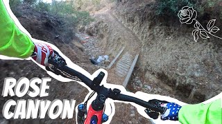
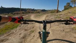
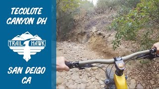
Saveri-Canyons refers to the urban canyon complex which includes Tecolote Canyon, Rose Canyon and Marian Bear Memorial Park. These urban canyons offer hikers, trail runners and mountain bikers an amazing getaway from the city right in their own backyard. Classic canyon-style riding with plenty of offshoots to explore. Watch out for poison oak
Tecolote Canyon is an urban canyon trail in Central Coastal San Diego just east Interstate 5, with lots of challenging features including deep sand, steep climbs, and creek crossings. There are new trails on the South end near the University of San Diego. Some traversing across neighborhoods to the north can connect you to San Clemente Canyon (Marian Bear Park) and Rose Canyon. Together this area is known as the Tri-Canyons area.
Tecolote Canyon is an urban canyon trail in Central Coastal San Diego just east Interstate 5, with lots of challenging features including deep sand, steep climbs, and creek crossings. There are new trails on the South end near the University of San Diego. Some traversing across neighborhoods to the north can connect you to San Clemente Canyon (Marian Bear Park) and Rose Canyon. Together this area is known as the Tri-Canyons area.
source: Tri-Canyons SDMBA webpage
Primary Trail Type: Cross-Country
Land Manager: City of San Diego
 google parking directions
 Activities Click to view
- Mountain Bike
49 trails
- E-Bike
15 trails
- Hike
49 trails
- Trail Running
48 trails
Region Details
- 6
- 6
- 14
- 21
- 1
Region Status
Caution as of Jun 9, 2026Stats
- Avg Trail Rating
- Trails (view details)
- 48
- Trails Mountain Bike
- 49
- Trails E-Bike
- 15
- Trails Gravel Bike
- 2
- Trails Adaptive Bike
- 2
- Trails Hike
- 49
- Trails Trail Running
- 48
- Total Distance
- 31 miles
- Total Descent
- 2,037 ft
- Total Vertical
- 362 ft
- Highest Trailhead
- 369 ft
- Reports
- 173
- Photos
- 100
- Ridden Counter
- 7,663
Popular Tri-Canyons Mountain Biking Trails
• 70 ★ 0.0 • 1,031 ft • 8 ft • 407 •
Flat section of mixed track takes you a bit east to access the neighborhood access trails.
• 75 ★ 3.0 • 592 ft • 41 ft • 402 •
Single track connect between Tecolote marker #7 and #8. This trail cuts out the steep dirt road with some single track. A couple rutted sections that don't do well in the mud make this a bit more than easy to ride. A couple punchy...
• 75 ★ 2.0 • 821 ft • 13 ft • 400 •
Connector between markers #9 and #10 follow right along the golf course fence. Mostly flat and narrow, but there is a difficult section that is really steep, but not loose. The dirt here is a bit like clay and tends to keep its hard...
• 65 ★ 4.0 • 4,222 ft • 30 ft • 354 •
This is a fun little trail that avoids the wide access road. It undulates through the hillside and offers some little punch ups and down and little trestle crossings over common muddy spots. There is a really cool section that takes you...
• 65 ★ 2.0 • 1 mile • 5 ft • 271 •
Moderately popular white difficulty paved path. This multi-use trail can be used both directions. On average it takes 7 minutes to complete this trail.
• 65 ★ 2.0 • 2,559 ft • 3 ft • 262 •
Moderately popular white difficulty paved path. This multi-use trail can be used both directions. On average it takes 3 minutes to complete this trail.
• 60 ★ 3.5 • 4 miles • 0 ft • 236 •
This is a piece of the - 12 miles of biking bliss. The San Diego County Bicycle Coalition's recommended route incorporates almost 12 miles of flat, scenic bike paths along most of the interior of the bay. With the exception of a few...
• 70 ★ 2.5 • 1,106 ft • 108 ft • 214 •
If you follow the official trail and aren't going to bushwhack along the creek that runs under Balboa Ave, you will need to follow the street up to the stoplight at Balboa and Clairemont to cross. Rather than backtracking along the road...
Tri-Canyons Mountain Bike Routes
10 miles • 667 ft • 6 • Point to Point •
Great moderate to easy riding through coastal canyons in Central San Diego. Easy access from many...
• 16 miles • 1,659 ft • 18 •
• 5 miles • 516 ft • 7 •
• 8 miles • 727 ft • 12 •
• 11 miles • 149 ft • 0 •
• 8 miles • 656 ft • 14 •
Photos of Tri-Canyons Mountain Bike
Videos of Tri-Canyons Mountain Bike

trail: September Street Trail
2:23 |
131 |
Jan 7, 2022
15:38 |
31 |
Oct 9, 2025 , San Diego

trail: Standley Trail
15:38 |
45 |
Oct 9, 2025 , San Diego

trail: Main Trail Marian Bear
15:38 |
63 |
Oct 9, 2025 , San Diego

trail: Brewery Loop
15:38 |
48 |
Oct 9, 2025 , San Diego
trail: Main Trail Marian Bear
11:38 |
669 |
Jan 10, 2021 , San Diego
trail: Tecolote Canyon North
11:48 |
1292 |
Sep 12, 2018 , San Diego
Current Trail Warnings
| status | trail | date | condition | user | info |
|---|---|---|---|---|---|
| Golf Course Connector | Jun 8, 2026 @ 1:04pm (America/Los_Angeles) Jun 8, 2026 | Unknown | dufury | Still closed due to construction. |
Recent Trail Reports
Activity Feed
| username | action | type | title | date |
|---|---|---|---|---|
| toddcbrown | vote | trail | activity #96715633 | Jun 10, 2026 @ 8:19pm Jun 10, 2026 |
| ev-dog | add | photo | activity #96654855 and 4 more | Jun 9, 2026 @ 10:57pm Jun 9, 2026 |
| ev-dog | add | report | activity #96654732 | Jun 9, 2026 @ 10:53pm Jun 9, 2026 |
| dufury | ridden | trail | activity #96559900 | Jun 8, 2026 @ 1:07pm Jun 8, 2026 |
| dufury | add | report | activity #96559609 and 8 more | Jun 8, 2026 @ 1:03pm Jun 8, 2026 |
Recent Comments
| username | type | title | comment | date |
|---|---|---|---|---|
| trail | arguably the best trail in the whole area | Jun 2, 2026 @ 6:52pm Jun 2, 2026 | ||
| trail | Other than being extremely overgrown, the... | Mar 21, 2026 @ 1:37pm Mar 21, 2026 | ||
| trail | DO NOT FALL IN THE RIVERS I HAVE SHOWERED... | Mar 1, 2026 @ 9:26pm Mar 1, 2026 | ||
| trail | Watch for snakes, I had a pretty close call. | Feb 26, 2026 @ 7:06pm Feb 26, 2026 | ||
| trail | Needs a bit of mowing | May 3, 2025 @ 9:37am May 3, 2025 |
Nearby Areas
| name | distance | ||||
|---|---|---|---|---|---|
| Rose Canyon | 4 | 1 | 1 | 2.2 km | |
| Balboa Park | 17 | 30 | 7 | 6.2 km | |
| Los Peñasquitos Canyon | 47 | 34 | 3 | 8 km | |
| Mission Trails Regional Park | 25 | 19 | 5 | 8.7 km | |
| City Heights | 8 | 1 | 1 | 8.7 km |
Local Badges
-

Completionist2 awarded
Activity Type Stats
| activitytype | trails | distance | descent | descent distance | total vertical | rating | global rank | state rank | photos | reports | routes | ridelogs |
|---|---|---|---|---|---|---|---|---|---|---|---|---|
| Mountain Bike | 49 | 31 miles | 2,037 ft | 10 miles | 361 ft | #4,307 | #1,522 | 100 | 173 | 1 | 15,360 | |
| E-Bike | 15 | 8 miles | 525 ft | 3 miles | 325 ft | #6,236 | #1,773 | 135 | 1 | 1,295 | ||
| Gravel Bike | 2 | #4,399 | #1,947 | 3 | 68 | |||||||
| Adaptive Bike | 2 | #4,393 | #1,942 | 2 | ||||||||
| Hike | 49 | 31 miles | 2,037 ft | 10 miles | 361 ft | #5,780 | #2,081 | 172 | 965 | |||
| Trail Running | 48 | 31 miles | 2,037 ft | 10 miles | 361 ft | #4,584 | #1,325 | 171 | 1,232 |
Frequently Asked Questions About Tri-Canyons
▼
What are the highest rated mountain biking trails in Tri-Canyons?
The highest rated mountain biking trails in Tri-Canyons are:
- Tecolote Canyon (East) (4.1/5)
- Battle Trail (4/5)
- Keller Canyon Trail (3.9/5)
- Bayside Walk (Mission Bay) (3.9/5)
- Brewery Loop (3.8/5)
▼
What is the best time of the year to ride in Tri-Canyons?
Based on ride log data, the most popular months to ride in Tri-Canyons are:
- July (90 activities)
- June (45 activities)
- May (44 activities)
▼
Where can I park to ride in Tri-Canyons?
There are 5 parking locations listed in Tri-Canyons. The most popular parking spots are: View all parking and trailhead locations on the map to plan your visit.
▼
What is the longest trail in Tri-Canyons?
The longest trail in Tri-Canyons is Mission Bay Bike Path at 12.9 km. View all trails sorted by distance.
Activities
Trails
Points of Interest
- By brenthillier
 NSMBA TRAILFORKS & contributors
 - Admins: SDMBA
- #9761 - 9,050 views
- tri-canyons activity log | embed map of Tri-Canyons mountain bike trails | tri-canyons mountain biking points of interest
Downloading of trail gps tracks in kml & gpx formats is enabled for Tri-Canyons.
You must login to download files.