close
-
Layers w
- Weather Layers
- Pro
- Pro
- Pro
- Pro
- Pro
- Pro
- More Layers
- Pro
- Pro
- Pro
- Pro
-
Upgrade to

3D
Trail Conditions
- Unknown
- Snow Groomed
- Snow Packed
- Snow Covered
- Snow Cover Partial
- Freeze/thaw Cycle
- Icy
- Prevalent Mud
- Wet
- Variable
- Ideal
- Dry
- Very Dry
Trail Flow (Ridden Direction)
Trailforks scans users ridelogs to determine the most popular direction each trail is ridden. A good flowing trail network will have most trails flowing in a single direction according to their intension.
The colour categories are based on what percentage of riders are riding a trail in its intended direction.
The colour categories are based on what percentage of riders are riding a trail in its intended direction.
- > 96%
- > 90%
- > 80%
- > 70%
- > 50%
- < 50%
- bi-directional trail
- no data
Trail Last Ridden
Trailforks scans ridelogs to determine the last time a trail was ridden.
- < 2 days
- < 1 week
- < 2 weeks
- < 1 month
- < 6 months
- > 6 months
Trail Ridden Direction
The intended direction a trail should be ridden.
- Downhill Only
- Downhill Primary
- Both Directions
- Uphill Primary
- Uphill Only
- One Direction
Contribute Details
Colors indicate trail is missing specified detail.
- Description
- Photos
- Description & Photos
- Videos
Trail Popularity ?
Trailforks scans ridelogs to determine which trails are ridden the most in the last 9 months.
Trails are compared with nearby trails in the same city region with a possible 25 colour shades.
Think of this as a heatmap, more rides = more kinetic energy = warmer colors.
- most popular
- popular
- less popular
- not popular
ATV/ORV/OHV Filter
Max Vehicle Width
inches
US Cell Coverage
Legend

Radar Time
Activity Recordings
Trailforks uses anonymized public activity data.
?
Activity Recordings
Trailforks uses anonymized public activity data.
?
Personal Heatmap
▶
Activity Types
all
/
none
▶
Options
2
Date range
month
–
Winter Trails
Warning
A routing network for winter maps does not exist. Selecting trails using the winter trails layer has been disabled.
Missing Trails
Most Popular
Least Popular
Trails are colored based on popularity. The more popular a trail is, the more red. Less popular trails trend towards green.
Jump Magnitude Heatmap
Heatmap of where riders jump on trails. Zoom in to see individual jumps, click circles to view jump details.
BC Backroad Status
![map legend]()
Service Road Atlas is a free to use, community-driven service for viewing and creating reports on the numerous back-country service roads around B.C. and Alberta.

Slope Aspect
Direction the slope faces
Trails Deemphasized
Trails are shown in grey.
Only show trails with no bike usage.
Suggested Layers
Based on selected activity type
Save the current map location and zoom level as your default home location whenever this page is loaded.
SaveThe Trowbridge Forest network of trails consists of 30km of mountain bike optimized single-track trail and 15km of Nordic double-track. The trails are broken out into two main areas;
Trowbridge Forest & Kinsmen Park: Trowbridge Forest consists of approximately 15km of double-track Nordic/ multi-use trails and 10km of single-track spread throughout the rolling hills above the Current River. The forest is dominated by a single large mesa and many of the trails in the area either climb or descend the slopes. All of the trails are accessible from the parking lot at Kinsmen Park on Copenhagen Rd. Make sure to check out the views of the iconic Trowbridge Falls from the footbridge into the trails. Key trails in the area include:
- Prospector Skills trail: A short beginner trail off the parking lot that offers riders a chance to learn all the skills they will need for the more advanced trails in the system. The main link is a pump track with rollers and berms. Two optional lines will introduce riders to large sections of rock work and a series of wooden technical trail features.
- Conveyor Belt: This 2.2km machine built beginner access trail will provide riders with the best way to enter the heart of the single-track system. The trail is dominated by the rocky tread, high ridgelines, and even a few views out to Lake Superior.
Shuniah Mines: Found in the center of Trowbridge Forest is the original legacy trail area know as Shuniah Mines. This section of the system contains 20km of purpose-built mountain bike single-track that winds through the century-old silver mine grounds and takes full advantage of the unique topography of tailing piles, rock features, and small ridgelines. The heart of Shuniah Mines is accessed easiest from the west end and the Balsam St trail head. Be on the lookout for the following signature trails;
- Grand Chasm: A 1.1km hand-built tech-flow intermediate trail that is known mostly for its iconic ‘Chasm Bridge’. For locals, it is a playground of optional features and unique lines. Keep an eye open for the old mining relics.
- Drift: A 1.6km machine built progressive flow trail that is the first of it’s kind in the region. High speeds, big berms and plenty of options to get airborne can all be found on this single-track rollercoaster. This trail is rated as intermediate.
- The Otherside: An advanced trail that defines the identity of Shuniah Mines, this trail is dominated by large bedrock knolls, hand-built tread, and hand-cut cedar features. The signature feature “The Waterfall” consists of a large section of pure rock tread that descends over nine meters to the base of a small cliff line.
In the heart of Shuniah Mines riders will find the Hydro Field Dirt Jumps. These advanced table-top jumps consist of a 6-pack main jump line ranging from 1.2 meters (4ft) to 4.25 meters (14ft). The optional B-line allows riders to opt-out before the three largest jumps.
Primary Trail Type: Cross-Country
Land Status: Managed by Local Riding Association
 google parking directions
Links
Region Supporters & Maintainers
trail builderSponsor
Activities Click to view
- Mountain Bike
67 trails
- E-Bike
9 trails
- Hike
61 trails
- Trail Running
61 trails
- Snowshoe
52 trails
- Nordic Ski
11 trails
Region Details
- 18
- 10
- 27
- 10
Region Status
Open as of 1 dayStats
- Avg Trail Rating
- Trails (view details)
- 65
- Trails Mountain Bike
- 67
- Trails E-Bike
- 9
- Trails Hike
- 61
- Trails Trail Running
- 61
- Trails Snowshoe
- 52
- Trails Nordic Ski
- 11
- Total Distance
- 31 miles
- Total Descent
- 2,377 ft
- Total Vertical
- 208 ft
- Highest Trailhead
- 995 ft
- Reports
- 6,789
- Photos
- 210
- Ridden Counter
- 20,780
Popular Trowbridge Forest Mountain Biking Trails
• 95 ★ 4.6 • 1 mile • 146 ft • 625 •
This beginner (green) level access trail provides all riders with an accessible trail into the heart of the trail system. Riders of all skill levels will enjoy the fast, flowing design of the machine built tread. From the Northside of...
• 100 ★ 3.3 • 1,335 ft • 27 ft • 523 •
Just rebuilt this summer of 2021. is a connecting trail with lots of rollers and two long bridges that brings you to the heart of Shuniah Mines.
• 90 ★ 4.6 • 3,556 ft • 38 ft • 472 •
Originally built in the the mid 90's the area around has seen significant changes over the years and multiple lines developed as local riders looked to take advantage of the terrain and natural features around the heart of the old...
• 95 ★ 3.9 • 1,417 ft • 0 ft • 415 •
was originally only a small 20m section of trail through a stand of spruce trees. Upgraded in 2015, the trail was expanded to be used as a mid-system climbing route back to the top of and other favourite trails in the heart of Shuniah...
• 95 ★ 4.5 • 4,797 ft • 10 ft • 409 •
Recently completed this August, is a taste of what's to come in the future of mountain biking in Trowbridge Forest. Starting from the top, the trail winds through the open boreal forest filled with lots of large berms and rollers. Keep...
• 90 ★ 4.6 • 965 ft • 0 ft • 366 •
Originally this trail was only a small connector trail linking single-track in Shunah Mines to the double-track in Centennial Park. In 2016 the trail was upgraded and is now the first machine built, downhill specific trail in the park....
• 90 ★ 3.9 • 1,214 ft • 10 ft • 357 •
A beginner level trail that will provide new riders with a safe and easy area to learn mountain biking skills. The trail is designed to accommodate both run bikes and pedal bikes. The main line is machine built dirt tread with small...
Trowbridge Forest Mountain Bike Routes
5 miles • 385 ft • 12 • Loop •
Shorter Route for Blacksheep's Poker Run (Sunday, July 30, 2023)
11 miles • 967 ft • 43 • Loop •
Rough guide for July 4th group ride with the Blacksheep Mountain Bike Club, led by Katherine Morency. This...
15 miles • 1,025 ft • 43 • Loop •
Long course for the 2023 Blacksheep Poker Ride.
6 miles • 398 ft • 19 • Loop •
Shorter Route for the Blacksheep Poker Run (Sunday, July 30, 2023
18 miles • 1,221 ft • 50 • Loop •
Both routes for printing for the Blacksheep Poker Ride.
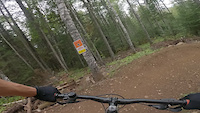
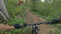
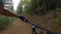
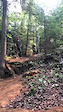
Photos of Trowbridge Forest Mountain Bike
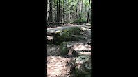
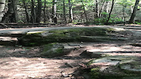
Videos of Trowbridge Forest Mountain Bike
trail: The Vein
0:40 |
170 |
Sep 11, 2023
trail: Scary Canary
0:19 |
256 |
Sep 4, 2023
trail: Drift
0:11 |
220 |
Sep 4, 2023
trail: Milk & Cookies
0:11 |
249 |
Jan 14, 2022
trail: Milk & Cookies
0:14 |
203 |
Jan 14, 2022
trail: Grand Chasm
0:09 |
391 |
Aug 18, 2021
trail: Grand Chasm
0:09 |
|
Aug 17, 2021

trail: Hill Top
0:55 |
197 |
Feb 17, 2020
Recent Trail Reports
| status | trail | date | condition | info | user |
|---|---|---|---|---|---|
| Portal | Jun 14, 2026 @ 1:39pm (America/Vancouver) Jun 14, 2026 | Variable | LeadOxide | ||
| Drift | Jun 14, 2026 @ 10:28am (America/Vancouver) Jun 14, 2026 | Variable | LeadOxide | ||
| Peekaboo | Jun 14, 2026 @ 10:23am (America/Vancouver) Jun 14, 2026 | Variable | LeadOxide | ||
| Crossover | Jun 14, 2026 @ 1:19pm (America/Toronto) Jun 14, 2026 | Ideal | LeadOxide | ||
| Conveyor Belt | Jun 14, 2026 @ 1:15pm (America/Toronto) Jun 14, 2026 | Variable | LeadOxide | ||
| Crosscut | May 21, 2026 @ 5:15pm (America/Vancouver) May 21, 2026 | Variable | LeadOxide | ||
| Hill Top | May 15, 2026 @ 9:52am (America/Toronto) May 15, 2026 | Ideal | lylemcd | ||
| The Stranger | May 15, 2026 @ 9:49am (America/Toronto) May 15, 2026 | Freeze/thaw Cycle | lylemcd | ||
| Grand Chasm | May 15, 2026 @ 9:46am (America/Toronto) May 15, 2026 | Ideal | lylemcd | ||
| Upper 2K Trail | May 15, 2026 @ 9:45am (America/Toronto) May 15, 2026 | Ideal | lylemcd |
Activity Feed
| username | action | type | title | date |
|---|---|---|---|---|
| Sanderson22 | update | route | activity #97042721 and 1 more | Jun 15, 2026 @ 8:20am Jun 15, 2026 |
| LeadOxide | checkin | trail | activity #97001509 | Jun 14, 2026 @ 1:39pm Jun 14, 2026 |
| LeadOxide | add | report | activity #97001507 | Jun 14, 2026 @ 1:39pm Jun 14, 2026 |
| LeadOxide | ridden | trail | activity #96983925 | Jun 14, 2026 @ 10:28am Jun 14, 2026 |
| LeadOxide | checkin | trail | activity #96983495 and 1 more | Jun 14, 2026 @ 10:23am Jun 14, 2026 |
Recent Comments
| username | type | title | comment | date |
|---|---|---|---|---|
| trail | wow great trail. would love to see it... | Feb 4, 2026 @ 6:40pm Feb 4, 2026 | ||
| trail | Also, wish there was a better climb trail to... | Aug 8, 2024 @ 12:49pm Aug 8, 2024 | ||
| trail | Wickedly awesome trail! But should be rated a... | Aug 8, 2024 @ 12:07pm Aug 8, 2024 | ||
| trail | Giant poop mid trail. Lynx? | Jul 30, 2024 @ 4:14pm Jul 30, 2024 | ||
| report | Tree cut off trail. All clear. | Apr 4, 2024 @ 9:34am Apr 4, 2024 |
Nearby Areas
| name | distance | ||||
|---|---|---|---|---|---|
| Centennial Park & the Bluffs | 2 | 0.9 km | |||
| Sleeping Giant Provincial Park | 4 | 8 | 1 | 20 km | |
| Mink Mountain | 22.2 km | ||||
| Silver Falls Provincial Park | 22.5 km | ||||
| Grand Portage State Park | 2 | 2 | 38.6 km |
Local Badges
-

The Miner0 awarded -

The Prospector272 awarded -

Completionist17 awarded
Bike & Skill Parks
| name | type | city | rating |
|---|---|---|---|
| Shuniah Mines Skills Area | skill park | Thunder Bay | |
| Kinsmen Bike Park | skill park | Thunder Bay |
Activity Type Stats
| activitytype | trails | distance | descent | descent distance | total vertical | rating | global rank | state rank | photos | reports | routes | ridelogs |
|---|---|---|---|---|---|---|---|---|---|---|---|---|
| Mountain Bike | 67 | 31 miles | 2,375 ft | 11 miles | 207 ft | #203 | #15 | 209 | 6,733 | 51 | 17,797 | |
| E-Bike | 9 | 4 miles | 479 ft | 2 miles | 144 ft | #4,402 | #98 | 2,366 | 2 | 100 | ||
| Hike | 61 | 29 miles | 2,031 ft | 10 miles | 207 ft | #4,073 | #70 | 1 | 9,661 | 587 | ||
| Trail Running | 61 | 29 miles | 2,031 ft | 10 miles | 207 ft | #2,631 | #19 | 1 | 9,660 | 19 | 2,031 | |
| Snowshoe | 52 | 27 miles | 1,926 ft | 9 miles | 207 ft | #247 | #16 | 6,924 | 109 | |||
| Nordic Ski | 11 | 9 miles | 748 ft | 4 miles | 207 ft | #441 | #24 | 6,735 | 102 |
Frequently Asked Questions About Trowbridge Forest
▼
What are the highest rated mountain biking trails in Trowbridge Forest?
The highest rated mountain biking trails in Trowbridge Forest are:
- Magma Day (4.5/5)
- Scary Canary (4.5/5)
- Grand Chasm (4.4/5)
- Hill Top (4.4/5)
- Blaster (4.4/5)
▼
What is the best time of the year to ride in Trowbridge Forest?
Based on ride log data, the most popular months to ride in Trowbridge Forest are:
- July (303 activities)
- June (284 activities)
- August (280 activities)
▼
Where can I park to ride in Trowbridge Forest?
There are 3 parking locations listed in Trowbridge Forest. The most popular parking spots are: View all parking and trailhead locations on the map to plan your visit.
▼
What is the longest trail in Trowbridge Forest?
The longest trail in Trowbridge Forest is Balsam Connector at 2.4 km. View all trails sorted by distance.
Activities
Trails
- By crohnsy & contributors
- Admins: BSMTB
- #5103 - 44,826 views
- trowbridge forest activity log | embed map of Trowbridge Forest mountain bike trails | trowbridge forest mountain biking points of interest
Downloading of trail gps tracks in kml & gpx formats is enabled for Trowbridge Forest.
You must login to download files.