close
-
Layers w
- Weather Layers
- Pro
- Pro
- Pro
- Pro
- Pro
- Pro
- More Layers
- Pro
- Pro
- Pro
- Pro
-
Upgrade to

3D
Trail Conditions
- Unknown
- Snow Groomed
- Snow Packed
- Snow Covered
- Snow Cover Partial
- Freeze/thaw Cycle
- Icy
- Prevalent Mud
- Wet
- Variable
- Ideal
- Dry
- Very Dry
Trail Flow (Ridden Direction)
Trailforks scans users ridelogs to determine the most popular direction each trail is ridden. A good flowing trail network will have most trails flowing in a single direction according to their intension.
The colour categories are based on what percentage of riders are riding a trail in its intended direction.
The colour categories are based on what percentage of riders are riding a trail in its intended direction.
- > 96%
- > 90%
- > 80%
- > 70%
- > 50%
- < 50%
- bi-directional trail
- no data
Trail Last Ridden
Trailforks scans ridelogs to determine the last time a trail was ridden.
- < 2 days
- < 1 week
- < 2 weeks
- < 1 month
- < 6 months
- > 6 months
Trail Ridden Direction
The intended direction a trail should be ridden.
- Downhill Only
- Downhill Primary
- Both Directions
- Uphill Primary
- Uphill Only
- One Direction
Contribute Details
Colors indicate trail is missing specified detail.
- Description
- Photos
- Description & Photos
- Videos
Trail Popularity ?
Trailforks scans ridelogs to determine which trails are ridden the most in the last 9 months.
Trails are compared with nearby trails in the same city region with a possible 25 colour shades.
Think of this as a heatmap, more rides = more kinetic energy = warmer colors.
- most popular
- popular
- less popular
- not popular
ATV/ORV/OHV Filter
Max Vehicle Width
inches
US Cell Coverage
Legend

Radar Time
Activity Recordings
Trailforks uses anonymized public activity data.
?
Activity Recordings
Trailforks uses anonymized public activity data.
?
Personal Heatmap
▶
Activity Types
all
/
none
▶
Options
2
Date range
month
–
Winter Trails
Warning
A routing network for winter maps does not exist. Selecting trails using the winter trails layer has been disabled.
Missing Trails
Most Popular
Least Popular
Trails are colored based on popularity. The more popular a trail is, the more red. Less popular trails trend towards green.
Jump Magnitude Heatmap
Heatmap of where riders jump on trails. Zoom in to see individual jumps, click circles to view jump details.
BC Backroad Status
![map legend]()
Service Road Atlas is a free to use, community-driven service for viewing and creating reports on the numerous back-country service roads around B.C. and Alberta.

Slope Aspect
Direction the slope faces
Trails Deemphasized
Trails are shown in grey.
Only show trails with no bike usage.
Suggested Layers
Based on selected activity type
Save the current map location and zoom level as your default home location whenever this page is loaded.
Save
No description for Twizel has been added yet!
Login or register to submit one.
Activities Click to view
- Mountain Bike
12 trails
- E-Bike
4 trails
- Gravel Bike
0 trails
- Adaptive Bike
0 trails
- Hike
10 trails
- Trail Running
10 trails
Region Details
- 4
- 3
- 1
Region Status
Open as of May 30, 2026Stats
- Avg Trail Rating
- Trails (view details)
- 8
- Trails Mountain Bike
- 12
- Trails E-Bike
- 4
- Trails Horse
- 1
- Trails Hike
- 10
- Trails Trail Running
- 10
- Total Distance
- 62 miles
- Total Descent
- 5,168 ft
- Total Vertical
- 3,279 ft
- Highest Trailhead
- 4,571 ft
- Reports
- 64
- Photos
- 18
- Ridden Counter
- 1,752
Popular Twizel Mountain Biking Trails
• 100 ★ 4.8 • 6 miles • 203 ft • 499 •
The Alps 2 Ocean Cycle Trail is truly one of New Zealand's great rides! For over 300 km visitors can experience some of the most beautiful scenery New Zealand has to offer. Suitable for all ages, the trail is an easy grade, and...
• 90 ★ 4.0 • 12 miles • 344 ft • 400 •
The Alps 2 Ocean Cycle Trail is truly one of New Zealand's great rides! For over 300 km visitors can experience some of the most beautiful scenery New Zealand has to offer. Suitable for all ages, the trail is an easy grade, and...
• 35 ★ 1.0 • 7 miles • 11 ft • 42 •
This is a lovely walk alongside Twizel River. The river is intermittently lined with willow trees that provide plenty of shade. Walkers may also enjoy the opportunity to find uncrowded swimming holes and picnic spots. This is a good...
• 25 ★ 0.0 • 5 miles • 853 ft • 26 •
Pyramid track takes you through farmland and pine plantations up over Pyramid Saddle and down into the valley on the other side. The climb is very steep in parts.
• 15 ★ 4.0 • 10 miles • 3,059 ft • 17 •
Best done in a clockwise direction. Steady and sometimes steep climb up beside the Greta Stream (wet feet on crossings) and then steep sidling up to the highest point, then a 900 metre altitude descent down a sometimes rocky 4WD track...
Twizel Mountain Bike Routes
8 miles • 1,705 ft • 0 • Point to Point •
From the Twizel side of the Ben Ohau Range, the Flanagan Pass Track begins at the end of the Pyramid...
Photos of Twizel Mountain Bike
Videos of Twizel Mountain Bike
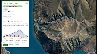
trail: Greta Valley Loop
0:15 |
8 |
Mar 12, 2026
trail: Greta Valley Loop
0:14 |
7 |
Mar 12, 2026
trail: Greta Valley Loop
0:09 |
7 |
Mar 12, 2026
trail: Greta Valley Loop
16:20 |
50 |
Mar 27, 2026 , Twizel
Recent Trail Reports
| status | trail | date | condition | info | user |
|---|---|---|---|---|---|
| Greta Valley Loop | Mar 12, 2026 @ 10:09am (Pacific/Auckland) Mar 11, 2026 | Variable | streddaz CCMBC | ||
| Alps 2 Ocean: Hayman Road start to Twizel | Feb 14, 2026 @ 12:29pm (Pacific/Auckland) Feb 13, 2026 | Ideal | graeme-mtb | ||
| Alps 2 Ocean: Glen Lyon Road to Lake Ohau Road | Nov 20, 2025 @ 8:50am (Pacific/Auckland) Nov 19, 2025 | Very Dry | Bethehow | ||
| Alps 2 Ocean: Twizel to Lake Ohau | Nov 20, 2025 @ 8:50am (Pacific/Auckland) Nov 19, 2025 | Very Dry | Bethehow | ||
| Twizel River Trail | Feb 11, 2023 @ 1:24am Feb 11, 2023 | Variable | JabberwockyNZ | ||
| Alps 2 Ocean: Twizel-Omarama Road to Glen Lyon Road | Mar 18, 2022 @ 2:06pm Mar 18, 2022 | Dry | Smitty231 |
Activity Feed
| username | action | type | title | date |
|---|---|---|---|---|
| Martinmcnamara | wishlist | trail | activity #96438401 | Jun 7, 2026 @ 2:22am Jun 7, 2026 |
| YogiNZ | ridden | trail | activity #95474382 and 2 more | May 25, 2026 @ 3:12am May 25, 2026 |
| Azza123456 | wishlist | trail | activity #94196313 | May 6, 2026 @ 8:20pm May 6, 2026 |
| palmaz | wishlist | trail | activity #92026330 | Apr 5, 2026 @ 8:47pm Apr 5, 2026 |
| camerasam | add | video | activity #91387422 | Mar 27, 2026 @ 11:39am Mar 27, 2026 |
Recent Comments
| username | type | title | comment | date |
|---|---|---|---|---|
| trail | You’re either extremely fit or in for a... | Mar 12, 2026 @ 12:05am Mar 12, 2026 | ||
| trail | Nice ride until 3-4 km mark when the trail... | Feb 24, 2026 @ 11:55pm Feb 24, 2026 | ||
| trail | Un | Feb 12, 2025 @ 10:18pm Feb 12, 2025 | ||
| trail | The gravel road is ardous to ride. Plenty of... | Apr 21, 2024 @ 4:37pm Apr 21, 2024 | ||
| trail | Increasingly overgrown from 3km mark, long... | Nov 21, 2023 @ 7:24pm Nov 21, 2023 |
Activity Type Stats
| activitytype | trails | distance | descent | descent distance | total vertical | rating | global rank | state rank | photos | reports | routes | ridelogs |
|---|---|---|---|---|---|---|---|---|---|---|---|---|
| Mountain Bike | 12 | 62 miles | 5,167 ft | 23 miles | 3,278 ft | #3,871 | #64 | 17 | 64 | 1 | 2,003 | |
| E-Bike | 4 | 18 miles | 3,304 ft | 7 miles | 3,278 ft | #1,208 | #29 | 64 | 1 | 165 | ||
| Horse | 1 | 7 miles | 230 ft | 3 miles | 217 ft | 3 | ||||||
| Hike | 10 | 50 miles | 4,219 ft | 17 miles | 3,278 ft | #3,931 | #55 | 62 | 105 | |||
| Trail Running | 10 | 50 miles | 4,219 ft | 17 miles | 3,278 ft | #3,338 | #46 | 62 | 64 |
Frequently Asked Questions About Twizel
▼
What are the highest rated mountain biking trails in Twizel?
The highest rated mountain biking trails in Twizel are:
- Alps 2 Ocean: Glen Lyon Road to Lake Ohau Road (4.2/5)
- Greta Valley Loop (4/5)
- Alps 2 Ocean: Hayman Road start to Twizel (4/5)
- Twizel River Trail (3.6/5)
- Pyramid Track (0/5)
▼
What is the best time of the year to ride in Twizel?
Based on ride log data, the most popular months to ride in Twizel are:
- October (14 activities)
- November (11 activities)
- April (8 activities)
▼
Where can I park to ride in Twizel?
There are 2 parking locations listed in Twizel. The most popular parking spots are:
▼
What is the longest trail in Twizel?
The longest trail in Twizel is Alps 2 Ocean: Hayman Road start to Twizel at 19.3 km. View all trails sorted by distance.
Trails
- By markholloway
 Trailforks Map Team & contributors
 - Admins: Alps2Ocean-Cycle-Trail, MBA, rhino333
- #27093 - 10,512 views
- twizel activity log | embed map of Twizel mountain bike trails | twizel mountain biking points of interest
Downloading of trail gps tracks in kml & gpx formats is enabled for Twizel.
You must login to download files.