close
-
Layers w
- Weather Layers
- Pro
- Pro
- Pro
- Pro
- Pro
- Pro
- More Layers
- Pro
- Pro
- Pro
- Pro
-
Upgrade to

3D
Trail Conditions
- Unknown
- Snow Groomed
- Snow Packed
- Snow Covered
- Snow Cover Partial
- Freeze/thaw Cycle
- Icy
- Prevalent Mud
- Wet
- Variable
- Ideal
- Dry
- Very Dry
Trail Flow (Ridden Direction)
Trailforks scans users ridelogs to determine the most popular direction each trail is ridden. A good flowing trail network will have most trails flowing in a single direction according to their intension.
The colour categories are based on what percentage of riders are riding a trail in its intended direction.
The colour categories are based on what percentage of riders are riding a trail in its intended direction.
- > 96%
- > 90%
- > 80%
- > 70%
- > 50%
- < 50%
- bi-directional trail
- no data
Trail Last Ridden
Trailforks scans ridelogs to determine the last time a trail was ridden.
- < 2 days
- < 1 week
- < 2 weeks
- < 1 month
- < 6 months
- > 6 months
Trail Ridden Direction
The intended direction a trail should be ridden.
- Downhill Only
- Downhill Primary
- Both Directions
- Uphill Primary
- Uphill Only
- One Direction
Contribute Details
Colors indicate trail is missing specified detail.
- Description
- Photos
- Description & Photos
- Videos
Trail Popularity ?
Trailforks scans ridelogs to determine which trails are ridden the most in the last 9 months.
Trails are compared with nearby trails in the same city region with a possible 25 colour shades.
Think of this as a heatmap, more rides = more kinetic energy = warmer colors.
- most popular
- popular
- less popular
- not popular
ATV/ORV/OHV Filter
Max Vehicle Width
inches
US Cell Coverage
Legend

Radar Time
Activity Recordings
Trailforks uses anonymized public activity data.
?
Activity Recordings
Trailforks uses anonymized public activity data.
?
Personal Heatmap
▶
Activity Types
all
/
none
▶
Options
2
Date range
month
–
Winter Trails
Warning
A routing network for winter maps does not exist. Selecting trails using the winter trails layer has been disabled.
Missing Trails
Most Popular
Least Popular
Trails are colored based on popularity. The more popular a trail is, the more red. Less popular trails trend towards green.
Jump Magnitude Heatmap
Heatmap of where riders jump on trails. Zoom in to see individual jumps, click circles to view jump details.
BC Backroad Status
![map legend]()
Service Road Atlas is a free to use, community-driven service for viewing and creating reports on the numerous back-country service roads around B.C. and Alberta.

Slope Aspect
Direction the slope faces
Trails Deemphasized
Trails are shown in grey.
Only show trails with no bike usage.
Suggested Layers
Based on selected activity type
Save the current map location and zoom level as your default home location whenever this page is loaded.
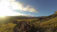
SaveFew people might think of mountain biking when they think about Uganda, but the conditions for cycling are actually great The area of Mount Elgon/Kapchorwa/Sipi falls is full of amazing single tracks that easily could be turned into world-class enduro trails, and there are endless single trails and dirt roads to explore in all parts of the country.
So if you are relocating to this country or visiting as a tourist, you should definitely bring your bike!
So if you are relocating to this country or visiting as a tourist, you should definitely bring your bike!
This region uses the Uk/Euro style trail grading system.
Stats
- Avg Trail Rating
- Trails (view details)
- 83
- Trails Mountain Bike
- 83
- Trails E-Bike
- 67
- Trails Gravel Bike
- 21
- Trails Adaptive Bike
- 8
- Trails Winter Fat Bike
- 3
- Trails Hike
- 83
- Trails Trail Running
- 83
- Total Distance
- 59 miles
- Total Descent
- 20,398 ft
- Total Vertical
- 6,254 ft
- Highest Trailhead
- 8,493 ft
- Reports
- 22
- Photos
- 12
- Ridden Counter
- 169
Sub Regions
- Central Region (28)
- Kampala District (3)
- Mukono District (25)
- Bule (25)
- Eastern Region (43)
- Kapchorwa District (43)
- Kapchorwa (14)
- Sipi Falls (32)
- Kapchorwa District (43)
- Mount Elgon (3)
- Moroto (3)
Popular Uganda Mountain Biking Trails
• 80 ★ 5.0 • 1 mile • 14 ft • 10 •
'Tabon Aret' means 'Good Trail' in the local language and is the best trail in this mini network around Fingers Rocks. Fast and technical with lots of small drops, wall ride, steep loose descents and a road gap jump (optional) near the end.
• 100 ★ 5.0 • 2,838 ft • 6 ft • 9 •
Mostly a blue trail with some technical features, but all easily rollable, no jumps or drops. It's been marked a black due to a short rock garden at the end, which is easily walkable. This is the first trail to access all the other...
• 85 ★ 5.0 • 1 mile • 11 ft • 8 •
Chameleon trail has been broken into multiple sections due to some short link roads (dirt roads) that link the singletrack together. It's an epic downhill trail ideal as a full day tour when linked with Dragon Lady.
• 5 ★ 5.0 • 3 miles • 10 ft • 8 •
Amazing technical trail with really good flow. Long hot and very rocky but will leave you with a big smile on your face!!
• 90 ★ 5.0 • 638 ft • 6 ft • 8 •
Another option into Manson's Fairytale for good riders, really technical, steep and difficult rock garden - natural and un-groomed. Have a scout / check before riding - especially the rock garden at the top. Right after the first rock...
• 85 ★ 5.0 • 3,543 ft • 12 ft • 6 •
Fast, tight and at times loose trail with lots of twists and turns. Pretty steep at the top and then mellows out into more flow at the bottom.
• 95 ★ 5.0 • 1 mile • 31 ft • 6 •
The epic end to Chameleon trail - bringing you down to the main Kapchorwa - Suam road. There's a little Duka (local shop) where you can buy a soda and a mandazi or biscuits.
• 65 ★ 4.5 • 1 mile • 648 ft • 6 •
The start is nowadays very tough - steep and eroded. There is, however, and easier b-line. Part of the trail is a bit rocky and cycling all the way up (only possible on the b-line) is very difficult, although it is still the easiest way up.
Uganda Mountain Bike Routes
★ 5.0 • 48 miles • 4,841 ft • 1 • Loop •
Long all day epic XC route - takes in amazing views from above Kapchorwa and then descends the mountain...
19 miles • 3,177 ft • 3 • Loop •
The race route used for the 2015 / 2016 and 2017 Mount Elgon MTB XC race.It's a beautiful trail with a mix...
9 miles • 1,389 ft • 0 • Loop •
This is a 15km loop ride from SIpi River Lodge. It is a beautiful ride that takes you up to the top of the...
21 miles • 4,582 ft • 7 • Shuttled • Race •
Race route for Sipi Enduro 2025 day1
15 miles • 3,217 ft • 9 • Shuttled • Race •
Race route for Sipi Enduro 2025 day2
Photos of Uganda Mountain Bike
Videos of Uganda Mountain Bike
trail: Tabon Aret
2:49 |
129 |
Jul 18, 2019

11:27 |
401 |
Feb 13, 2019
Recent Comments
| username | type | title | comment | date |
|---|---|---|---|---|
| trail | Siick!!!???????? | Apr 9, 2019 @ 11:53am Apr 9, 2019 |
Bike & Skill Parks
| name | type | city | rating |
|---|---|---|---|
| Kansanje Bike Park | skill park | Entebbe |
Activity Type Stats
| activitytype | trails | distance | descent | descent distance | total vertical | rating | global rank | state rank | photos | reports | routes | ridelogs |
|---|---|---|---|---|---|---|---|---|---|---|---|---|
| Mountain Bike | 83 | 59 miles | 20,397 ft | 41 miles | 6,253 ft | #80 | 12 | 22 | 8 | 1,495 | ||
| E-Bike | 67 | 44 miles | 14,941 ft | 31 miles | 4,751 ft | #79 | 21 | 5 | 3 | |||
| Gravel Bike | 21 | 5 miles | 2,014 ft | 4 miles | 2,080 ft | #41 | 4 | 1 | ||||
| Adaptive Bike | 8 | 5 miles | 1,965 ft | 4 miles | 2,198 ft | #38 | 1 | |||||
| Winter Fat Bike | 3 | 4 miles | 1,247 ft | 3 miles | 1,860 ft | #39 | ||||||
| Hike | 83 | 59 miles | 20,397 ft | 41 miles | 6,253 ft | #88 | 22 | 159 | ||||
| Trail Running | 83 | 59 miles | 20,397 ft | 41 miles | 6,253 ft | #85 | 22 | 4 |
Activities
Trails
Points of Interest
- By Bicycles-for-humanity & contributors
- Admins: UE
- #25399 - 3,913 views
- uganda activity log | embed map of Uganda mountain bike trails | uganda mountain biking points of interest
Downloading of trail gps tracks in kml & gpx formats is enabled for Uganda.
You must login to download files.