close
-
Layers w
- Weather Layers
- Pro
- Pro
- Pro
- Pro
- Pro
- Pro
- More Layers
- Pro
- Pro
- Pro
- Pro
-
Upgrade to

3D
Trail Conditions
- Unknown
- Snow Groomed
- Snow Packed
- Snow Covered
- Snow Cover Partial
- Freeze/thaw Cycle
- Icy
- Prevalent Mud
- Wet
- Variable
- Ideal
- Dry
- Very Dry
Trail Flow (Ridden Direction)
Trailforks scans users ridelogs to determine the most popular direction each trail is ridden. A good flowing trail network will have most trails flowing in a single direction according to their intension.
The colour categories are based on what percentage of riders are riding a trail in its intended direction.
The colour categories are based on what percentage of riders are riding a trail in its intended direction.
- > 96%
- > 90%
- > 80%
- > 70%
- > 50%
- < 50%
- bi-directional trail
- no data
Trail Last Ridden
Trailforks scans ridelogs to determine the last time a trail was ridden.
- < 2 days
- < 1 week
- < 2 weeks
- < 1 month
- < 6 months
- > 6 months
Trail Ridden Direction
The intended direction a trail should be ridden.
- Downhill Only
- Downhill Primary
- Both Directions
- Uphill Primary
- Uphill Only
- One Direction
Contribute Details
Colors indicate trail is missing specified detail.
- Description
- Photos
- Description & Photos
- Videos
Trail Popularity ?
Trailforks scans ridelogs to determine which trails are ridden the most in the last 9 months.
Trails are compared with nearby trails in the same city region with a possible 25 colour shades.
Think of this as a heatmap, more rides = more kinetic energy = warmer colors.
- most popular
- popular
- less popular
- not popular
ATV/ORV/OHV Filter
Max Vehicle Width
inches
US Cell Coverage
Legend

Radar Time
Activity Recordings
Trailforks uses anonymized public activity data.
?
Activity Recordings
Trailforks uses anonymized public activity data.
?
Personal Heatmap
▶
Activity Types
all
/
none
▶
Options
2
Date range
month
–
Winter Trails
Warning
A routing network for winter maps does not exist. Selecting trails using the winter trails layer has been disabled.
Missing Trails
Most Popular
Least Popular
Trails are colored based on popularity. The more popular a trail is, the more red. Less popular trails trend towards green.
Jump Magnitude Heatmap
Heatmap of where riders jump on trails. Zoom in to see individual jumps, click circles to view jump details.
BC Backroad Status
![map legend]()
Service Road Atlas is a free to use, community-driven service for viewing and creating reports on the numerous back-country service roads around B.C. and Alberta.

Slope Aspect
Direction the slope faces
Trails Deemphasized
Trails are shown in grey.
Only show trails with no bike usage.
Suggested Layers
Based on selected activity type
Save the current map location and zoom level as your default home location whenever this page is loaded.
SaveUkraine is a large country that’s predominantly flat. Of the two mountain ranges in Ukraine, as of 2014, lift-accessed bike parks exist only in the Carpathians, in Bukovel (http://bukovelbikepark.com/en/), Zahar Berkut (https://zaharberkut.ua/en/services-and-activities/bike-park/) and Pylypets (http://grandhotelpylypets.com/en/bicyclesen). New bike park with lifts opened in 2022 Bike Park Play (https://www.instagram.com/bike_park_play/). The Crimean mountains also boast a number of trails, though disputed status of Crimea complicates access.
Cross-country races held in Ukraine are aggregated at http://bikeportal.org.ua/.
TODO: add similar information regarding other disciplines of cycling.
Cross-country races held in Ukraine are aggregated at http://bikeportal.org.ua/.
TODO: add similar information regarding other disciplines of cycling.
AKA: Україна
Region Details
- 142
- 3
- 73
- 173
- 14
- 4
Stats
- Avg Trail Rating
- Trails (view details)
- 515
- Trails Mountain Bike
- 521
- Trails E-Bike
- 431
- Trails Horse
- 3
- Trails Hike
- 96
- Trails Trail Running
- 102
- Trails Dirtbike/Moto
- 5
- Trails Observed Trials
- 1
- Trails ATV/ORV/OHV
- 1
- Total Distance
- 761 miles
- Total Descent
- 251,784 ft
- Total Vertical
- 6,698 ft
- Highest Trailhead
- 6,706 ft
- Reports
- 1,180
- Photos
- 1,112
- Ridden Counter
- 4,487
Sub Regions
- Cherkasy Oblast (0)
- Chernihiv (0)
- Crimea (374)
- Южный Берег Крыма (337)
- Feodosia (6)
- Kerch (19)
- Sevastopol (6)
- Simferopol (5)
- Dnipropetrovsk (0)
- Donetsk (0)
- Kharkiv (11)
- Kharkov (11)
- Kharkov (11)
- Kherson (0)
- Khmelnytskyi (0)
- Kiev (4)
- Kirovohrad (2)
- Kramatorsk (15)
- Sviatohirsk (15)
- Sviatohirsk (15)
- Kyiv (1)
- Kyiv (1)
- Kyiv (1)
- Luhansk (5)
- Dovzhansk (4)
- Dovzhansk (4)
- Lviv (7)
- Mykolaiv (0)
- Odessa (0)
- Poltava (7)
- Khorol (2)
- kremenchug (4)
- Khorol (2)
- Sumy (0)
- Ternopil (10)
- Krzemieniec (3)
- Ternopil (7)
- Krzemieniec (3)
- Vinnytsia (3)
- Volyn (0)
- Zakarpatska (23)
- Ivano-Frankivsk (7)
- Polyanytsya (7)
- Uzhhorod (8)
- Yaremche (1)
- Ворохта (4)
- Ivano-Frankivsk (7)
- Zakarpattia (9)
- Zaporizhia (3)
- Zaporozhye (7)
- Zaporozhye (7)
- Zhytomyr (0)
- Dnipro (6)
- Kramatorsk (21)
- Kropyvnytskyi (2)
- Mohyliv-Podil's'kyi (2)
- Vinnitsa (3)
Popular Ukraine Mountain Biking Trails
• 90 ★ 4.6 • 630 ft • 0 ft • 195 •
Popular green difficulty singletrack. This mountain bike primary trail can be used downhill only and has a moderate overall physical rating. Trail visibility is always easy to follow. On average it takes minutes to complete this trail.
• 100 ★ 5.0 • 820 ft • 0 ft • 191 •
Popular blue difficulty singletrack. This mountain bike primary trail can be used downhill only and has a moderate overall physical rating with a 0 ft green climb. It features pump track. Trail visibility is sometimes hard to follow. On average it takes 3 minutes to complete this trail.
• 100 ★ 5.0 • 3,038 ft • 6 ft • 181 •
Highly rated popular blue difficulty singletrack. This mountain bike primary trail can be used downhill only and has a moderate overall physical rating with a 6 ft green climb. It features roller coaster and skinny. Trail visibility is sometimes hard to follow. On average it takes 4 minutes to complete this trail.
• 90 ★ 5.0 • 3,907 ft • 38 ft • 176 •
Popular red difficulty singletrack. This mountain bike primary trail can be used downhill only. On average it takes 5 minutes to complete this trail.
• 100 ★ 0.0 • 3,842 ft • 16 ft • 170 •
Popular blue difficulty singletrack. This mountain bike primary trail can be used downhill only and has a moderate overall physical rating with a 16 ft blue climb. Trail visibility is always easy to follow. On average it takes 3 minutes to complete this trail.
• 95 ★ 5.0 • 2,474 ft • 0 ft • 162 •
Highly rated popular blue difficulty singletrack. This mountain bike primary trail can be used downhill only and has a moderate overall physical rating with a 0 ft blue climb. It features berm, drop, jump, rock face, rock garden and other. Trail visibility is sometimes hard to follow. On average it takes 4 minutes to complete this trail.
• 85 ★ 4.9 • 2 miles • 56 ft • 158 •
Один из лучших флоу трейлов Алушты! 4 км нонстоп скорости и флоу
Ukraine Mountain Bike Routes
★ 5.0 • 20 miles • 837 ft • 0 • Point to Point •
Круг удовольствия через заповедник "Крейдова флора" и...
14 miles • 2,594 ft • 10 • Shuttled •
Связка классических уклонистых трейлов начиная от...
★ 5.0 • 16 miles • 1,629 ft • 0 • Point to Point •
Easy and relax ride through the park
★ 5.0 • 12 miles • 1,343 ft • 0 • Loop •
Loop with steep descents and several hilly sections, suitable for XC and enduro bikes. Caution on descents!
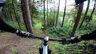
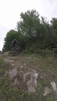
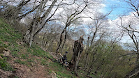
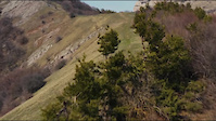
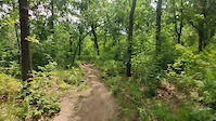
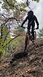
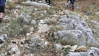
Photos of Ukraine Mountain Bike
Videos of Ukraine Mountain Bike
trail: Zahar DH
0:12 |
48 |
Feb 2, 2025
trail: Zahar DH
0:06 |
65 |
Jul 29, 2024

trail: Лавровый
0:40 |
16 |
Mar 18, 2023
trail: Мрiя
0:15 |
73 |
Apr 30, 2022
trail: Иван
0:00 |
45 |
Nov 11, 2021
trail: Ledachi Golubci
0:00 |
28 |
Jun 14, 2021
trail: Ягодка
0:06 |
67 |
Apr 24, 2021
trail: Ягодка
0:08 |
93 |
Apr 24, 2021
Recent Comments
| username | type | title | comment | date |
|---|---|---|---|---|
| trail | why is a proline? | Feb 10, 2025 @ 3:52am Feb 10, 2025 | ||
| trail | С великом очень сложно... | Oct 26, 2024 @ 2:22pm Oct 26, 2024 | ||
| report | Че за nah | Sep 15, 2024 @ 9:03am Sep 15, 2024 | ||
| trail | Хороший маршрут | Aug 11, 2023 @ 7:41am Aug 11, 2023 | ||
| trail | Данный трек незаконно... | Apr 11, 2023 @ 11:43pm Apr 11, 2023 |
Bike & Skill Parks
| name | type | city | rating |
|---|---|---|---|
| Bukovel Bike Park | bike park | Polyanytsya | |
| Pylypets Bike Park | bike park | Pylypets | |
| Zahar Berkut bike park | bike park | Slavske | |
| Осокорки | bike park | Kiev | |
| Life On Dirt Bike Park | skill park | Khorol |
Activity Type Stats
| activitytype | trails | distance | descent | descent distance | total vertical | rating | global rank | state rank | photos | reports | routes | ridelogs |
|---|---|---|---|---|---|---|---|---|---|---|---|---|
| Mountain Bike | 517 | 761 miles | 251,785 ft | 415 miles | 6,699 ft | #40 | 1,112 | 1,177 | 36 | 38,851 | ||
| E-Bike | 431 | 638 miles | 215,440 ft | 344 miles | 5,213 ft | #40 | 1,135 | 16 | 1,552 | |||
| Horse | 3 | #51 | 217 | 3 | ||||||||
| Hike | 96 | 111 miles | 24,432 ft | 61 miles | 6,621 ft | #73 | 957 | 5 | 1,099 | |||
| Trail Running | 102 | 115 miles | 25,545 ft | 64 miles | 6,621 ft | #63 | 962 | 7 | 174 | |||
| Dirtbike/Moto | 5 | 5 miles | 577 ft | 2 miles | 3,412 ft | #44 | 220 | 1 | 5 | |||
| Observed Trials | 1 | 1,772 ft | 82 ft | #34 | ||||||||
| ATV/ORV/OHV | 1 | 1,772 ft | 82 ft | #39 | 216 | 1 | 1 |
Activities
Trails
- By canadaka
 Trailforks & contributors
 - Admins: bartek457
- #3248 - 25,352 views
- ukraine activity log | embed map of Ukraine mountain bike trails | ukraine mountain biking points of interest polygons
Downloading of trail gps tracks in kml & gpx formats is enabled for Ukraine.
You must login to download files.