close
-
Layers w
- Weather Layers
- Pro
- Pro
- Pro
- Pro
- Pro
- Pro
- More Layers
- Pro
- Pro
- Pro
- Pro
-
Upgrade to

3D
Trail Conditions
- Unknown
- Snow Groomed
- Snow Packed
- Snow Covered
- Snow Cover Partial
- Freeze/thaw Cycle
- Icy
- Prevalent Mud
- Wet
- Variable
- Ideal
- Dry
- Very Dry
Trail Flow (Ridden Direction)
Trailforks scans users ridelogs to determine the most popular direction each trail is ridden. A good flowing trail network will have most trails flowing in a single direction according to their intension.
The colour categories are based on what percentage of riders are riding a trail in its intended direction.
The colour categories are based on what percentage of riders are riding a trail in its intended direction.
- > 96%
- > 90%
- > 80%
- > 70%
- > 50%
- < 50%
- bi-directional trail
- no data
Trail Last Ridden
Trailforks scans ridelogs to determine the last time a trail was ridden.
- < 2 days
- < 1 week
- < 2 weeks
- < 1 month
- < 6 months
- > 6 months
Trail Ridden Direction
The intended direction a trail should be ridden.
- Downhill Only
- Downhill Primary
- Both Directions
- Uphill Primary
- Uphill Only
- One Direction
Contribute Details
Colors indicate trail is missing specified detail.
- Description
- Photos
- Description & Photos
- Videos
Trail Popularity ?
Trailforks scans ridelogs to determine which trails are ridden the most in the last 9 months.
Trails are compared with nearby trails in the same city region with a possible 25 colour shades.
Think of this as a heatmap, more rides = more kinetic energy = warmer colors.
- most popular
- popular
- less popular
- not popular
ATV/ORV/OHV Filter
Max Vehicle Width
inches
US Cell Coverage
Legend

Radar Time
Activity Recordings
Trailforks uses anonymized public activity data.
?
Activity Recordings
Trailforks uses anonymized public activity data.
?
Personal Heatmap
▶
Activity Types
all
/
none
▶
Options
2
Date range
month
–
Winter Trails
Warning
A routing network for winter maps does not exist. Selecting trails using the winter trails layer has been disabled.
Missing Trails
Most Popular
Least Popular
Trails are colored based on popularity. The more popular a trail is, the more red. Less popular trails trend towards green.
Jump Magnitude Heatmap
Heatmap of where riders jump on trails. Zoom in to see individual jumps, click circles to view jump details.
BC Backroad Status
![map legend]()
Service Road Atlas is a free to use, community-driven service for viewing and creating reports on the numerous back-country service roads around B.C. and Alberta.

Slope Aspect
Direction the slope faces
Trails Deemphasized
Trails are shown in grey.
Only show trails with no bike usage.
Suggested Layers
Based on selected activity type
Save the current map location and zoom level as your default home location whenever this page is loaded.
Save
No description for Upper Pemberton and Signal Hill has been added yet!
Login or register to submit one.
Primary Trail Type: All-Mountain & Downhill
eBikes Allowed:
Yes
Activities Click to view
- Mountain Bike
12 trails
- E-Bike
15 trails
- Horse
2 trails
- Hike
24 trails
- Trail Running
24 trails
Region Details
- 3
- 6
- 2
Region Status
Caution as of May 17, 2026Stats
- Avg Trail Rating
- Global Ranking
- #4,732
- Trails (view details)
- 15
- Trails Mountain Bike
- 12
- Trails E-Bike
- 15
- Trails Horse
- 2
- Trails Hike
- 24
- Trails Trail Running
- 24
- Trails Dirtbike/Moto
- 2
- Trails Snowshoe
- 2
- Total Distance
- 8 miles
- Total Descent Distance
- 4 miles
- Total Descent
- 2,848 ft
- Total Vertical
- 885 ft
- Highest Trailhead
- 1,651 ft
- Reports
- 221
- Photos
- 128
- Ridden Counter
- 7,790
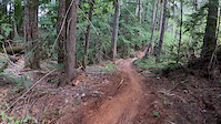
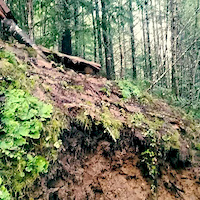
Popular Upper Pemberton and Signal Hill Trails
• 85 ★ 4.5 • 1 mile • 12 ft • 1,147 •
Fast, flowy, super fun trail with a bit of everything, named after the Driftwood Brewery IPA. Nothing too tricky. When climbing, after going across the log ride, make sure you go under the wood structure and make it to the very top of...
• 90 ★ 4.5 • 4,560 ft • 519 ft • 1,059 •
Very difficult climb that accesses the trails.
• 35 ★ 2.8 • 2,346 ft • 14 ft • 178 •
Less popular double black diamond difficulty singletrack. This mountain bike primary trail can be used downhill only. On average it takes 9 minutes to complete this trail.
• 55 ★ 4.0 • 2,825 ft • 111 ft • 168 •
an old multi use trail for hikers, bikers, horse riders and dog walkers. Use it to access the MTB climb trail and the Tour de Soo Horse/ trails further South.
• 25 ★ 4.2 • 2,648 ft • 4 ft • 127 •
Less popular double black diamond difficulty singletrack. This mountain bike primary trail can be used downhill only. On average it takes 9 minutes to complete this trail.
• 15 ★ 4.0 • 1,293 ft • 36 ft • 36 •
Less popular black diamond difficulty singletrack. This mountain bike primary trail can be used one direction. On average it takes 7 minutes to complete this trail.
Mountain Bike Routes
3 miles • 845 ft • 3 •
..And this week's fiver is back on to end spring fivers off with a favourite lap! Course: Sign In Time:...
3 miles • 845 ft • 3 •
PORCA Fiver #2 April 15th This week we are headed for a fun lap on brought to you by Bike Co. and over to...
3 miles • 870 ft • 3 •
This week’s Fiver is brought to you by Dorgelo and Mile One Eating House. Sign In Time: 6:00 PM Sign-In...
2 miles • 770 ft • 3 •
Kick off to Toonie Season starts with sponsors Pemberton Bike Co. and Blackbird Bakery hosting a lap on...
Videos of Upper Pemberton and Signal Hill Mountain Bike
trail: Fat Tug
0:02 |
414 |
Jun 2, 2020
trail: Fat Tug
0:08 |
2432 |
Feb 17, 2015
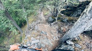
trail: Jank Ribbon
3:34 |
249 |
Nov 30, 2023 , Pemberton
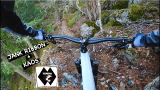
trail: Kaos
7:35 |
193 |
Nov 28, 2023 , Pemberton
youtuber
![JANK RIBBON + KAOS | Double black trail |...]()

trail: Jank Ribbon
7:35 |
202 |
Nov 28, 2023 , Pemberton
trail: Fat Tug
5:54 |
248 |
Nov 17, 2023 , Pemberton

Recent Trail Reports
| status | trail | date | condition | info | user |
|---|---|---|---|---|---|
| Smoky Tickler | Jan 31, 2026 @ 1:11pm (America/Vancouver) Jan 31, 2026 | Variable | Woodyvalley | ||
| Fat Tug Access | Aug 9, 2025 @ 9:23am Aug 9, 2025 | Dry | wadeinbc | ||
| Tour de Soo 1 | May 18, 2025 @ 11:18am May 18, 2025 | Dry | NickNat | ||
| Fat Tug | May 10, 2025 @ 7:40am May 10, 2025 | Ideal | dalet | ||
| Banjo Connector | Sep 24, 2024 @ 10:33pm Sep 24, 2024 | Unknown | canadaka Trailforks | ||
| Jank Ribbon | Mar 23, 2024 @ 5:54pm Mar 23, 2024 | Variable | Ruguma | ||
| Connector | Feb 18, 2024 @ 8:42am Feb 18, 2024 | Snow Cover Partial | Ruguma | ||
| Connector | Aug 31, 2023 @ 4:06pm Aug 31, 2023 | Ideal | ewalton56 | ||
| Kaos | Jun 8, 2023 @ 9:28am Jun 8, 2023 | Very Dry | superfunk649 |
Activity Feed
| username | action | type | title | date |
|---|---|---|---|---|
| Jakeraine66 | add | route | activity #96938123 | Jun 13, 2026 @ 9:23pm Jun 13, 2026 |
| PORCA-bikes | add | route | activity #96114573 | Jun 2, 2026 @ 3:47pm Jun 2, 2026 |
| bymm | ridden | trail | activity #94695679 | May 14, 2026 @ 9:32am May 14, 2026 |
| Paugalceran | wishlist | route | activity #94402289 | May 10, 2026 @ 12:21am May 10, 2026 |
| AndreaLevet | ridden | trail | activity #94004172 and 1 more | May 3, 2026 @ 8:03pm May 3, 2026 |
Recent Comments
| username | type | title | comment | date |
|---|---|---|---|---|
| trail | Built for ebikes and olympians. A good challenge | May 25, 2025 @ 4:11pm May 25, 2025 | ||
| trail | Fast, flowy, and difficult to follow due to... | May 25, 2025 @ 4:10pm May 25, 2025 | ||
| report | Ih6nonhbha3qfawa,vg great g. D, vd ddvjf4... | Mar 25, 2024 @ 2:34pm Mar 25, 2024 | ||
| trail | The guy below me can’t climb | Jul 22, 2023 @ 7:14pm Jul 22, 2023 | ||
| trail | Tree down on the climb. Running great after... | May 22, 2023 @ 10:16am May 22, 2023 |
Nearby Areas
| name | distance | ||||
|---|---|---|---|---|---|
| Valley | 3 | 1.6 km | |||
| One Mile Lake | 11 | 11 | 9 | 2 | 1.8 km |
| Mackenzie | 4 | 17 | 15 | 9 | 2.4 km |
| Mosquito Lake | 9 | 39 | 17 | 7 | 3.5 km |
| South Rutherford | 2 | 2 | 2 | 3 | 5.4 km |
Local Products
Activity Type Stats
| activitytype | trails | distance | descent | descent distance | total vertical | rating | global rank | state rank | photos | reports | routes | ridelogs |
|---|---|---|---|---|---|---|---|---|---|---|---|---|
| Mountain Bike | 12 | 6 miles | 2,316 ft | 3 miles | 886 ft | #4,732 | 105 | 218 | 7 | 5,682 | ||
| E-Bike | 15 | 7 miles | 2,418 ft | 4 miles | 886 ft | #6,613 | #248 | 182 | 1 | 148 | ||
| Horse | 2 | #775 | #20 | 15 | 70 | 1 | ||||||
| Hike | 24 | 8 miles | 2,848 ft | 4 miles | 886 ft | #9,224 | #360 | 8 | 219 | 455 | ||
| Trail Running | 24 | 8 miles | 2,848 ft | 4 miles | 886 ft | #9,649 | #363 | 219 | 282 | |||
| Dirtbike/Moto | 2 | 4,354 ft | 131 ft | 318 ft | 95 | 3 | ||||||
| Snowshoe | 2 | 1 mile | 430 ft | 2,408 ft | 167 ft | 27 | 3 |
Frequently Asked Questions About Upper Pemberton and Signal Hill
▼
What are the highest rated mountain biking trails in Upper Pemberton and Signal Hill?
The highest rated mountain biking trails in Upper Pemberton and Signal Hill are:
- Smoky Tickler (4.4/5)
- Fat Tug (4.3/5)
- Kaos (4.1/5)
- Banjo Connector (4/5)
- Tour de Soo 1 (4/5)
▼
What is the best time of the year to ride in Upper Pemberton and Signal Hill?
Based on ride log data, the most popular months to ride in Upper Pemberton and Signal Hill are:
- May (83 activities)
- July (83 activities)
- April (75 activities)
▼
Where can I park to ride in Upper Pemberton and Signal Hill?
Check the Upper Pemberton and Signal Hill trail map for trailhead and parking information. Community members regularly update access and parking details for trails in the area.
▼
What is the longest trail in Upper Pemberton and Signal Hill?
The longest trail in Upper Pemberton and Signal Hill is Fat Tug at 1.3 miles. View all trails sorted by distance.
Activities
- By brenthillier
 NSMBA TRAILFORKS & contributors
 - Admins: PORCA, PVTA, HowlerContractingLimited, Pembree, PORCA, PVTA, sjf405, 99, snowdan
- #4700 - 9,819 views
- upper pemberton and signal hill activity log | embed map of Upper Pemberton and Signal Hill mountain bike trails | upper pemberton and signal hill mountain biking points of interest polygons
Downloading of trail gps tracks in kml & gpx formats is enabled for Upper Pemberton and Signal Hill.
You must login to download files.