close
-
Layers w
- Weather Layers
- Pro
- Pro
- Pro
- Pro
- Pro
- Pro
- More Layers
- Pro
- Pro
- Pro
- Pro
-
Upgrade to

3D
Trail Conditions
- Unknown
- Snow Groomed
- Snow Packed
- Snow Covered
- Snow Cover Partial
- Freeze/thaw Cycle
- Icy
- Prevalent Mud
- Wet
- Variable
- Ideal
- Dry
- Very Dry
Trail Flow (Ridden Direction)
Trailforks scans users ridelogs to determine the most popular direction each trail is ridden. A good flowing trail network will have most trails flowing in a single direction according to their intension.
The colour categories are based on what percentage of riders are riding a trail in its intended direction.
The colour categories are based on what percentage of riders are riding a trail in its intended direction.
- > 96%
- > 90%
- > 80%
- > 70%
- > 50%
- < 50%
- bi-directional trail
- no data
Trail Last Ridden
Trailforks scans ridelogs to determine the last time a trail was ridden.
- < 2 days
- < 1 week
- < 2 weeks
- < 1 month
- < 6 months
- > 6 months
Trail Ridden Direction
The intended direction a trail should be ridden.
- Downhill Only
- Downhill Primary
- Both Directions
- Uphill Primary
- Uphill Only
- One Direction
Contribute Details
Colors indicate trail is missing specified detail.
- Description
- Photos
- Description & Photos
- Videos
Trail Popularity ?
Trailforks scans ridelogs to determine which trails are ridden the most in the last 9 months.
Trails are compared with nearby trails in the same city region with a possible 25 colour shades.
Think of this as a heatmap, more rides = more kinetic energy = warmer colors.
- most popular
- popular
- less popular
- not popular
ATV/ORV/OHV Filter
Max Vehicle Width
inches
US Cell Coverage
Legend

Radar Time
Activity Recordings
Trailforks uses anonymized public activity data.
?
Activity Recordings
Trailforks uses anonymized public activity data.
?
Personal Heatmap
▶
Activity Types
all
/
none
▶
Options
2
Date range
month
–
Winter Trails
Warning
A routing network for winter maps does not exist. Selecting trails using the winter trails layer has been disabled.
Missing Trails
Most Popular
Least Popular
Trails are colored based on popularity. The more popular a trail is, the more red. Less popular trails trend towards green.
Jump Magnitude Heatmap
Heatmap of where riders jump on trails. Zoom in to see individual jumps, click circles to view jump details.
BC Backroad Status
![map legend]()
Service Road Atlas is a free to use, community-driven service for viewing and creating reports on the numerous back-country service roads around B.C. and Alberta.

Slope Aspect
Direction the slope faces
Trails Deemphasized
Trails are shown in grey.
Only show trails with no bike usage.
Suggested Layers
Based on selected activity type
Save the current map location and zoom level as your default home location whenever this page is loaded.
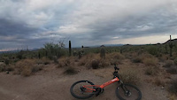
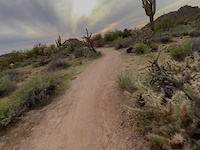
SaveLocated on the Valley’s east side, this park takes in 3,648 acres set at the western end of the Goldfield Mountains, adjacent to the Tonto National Forest.
Usery Mountain Regional Park offers over 29 miles of trails for hiking, mountain biking and horseback riding. Park trails range in length from 0.2 miles to over 7 miles, and range in difficulty from easy to difficult.
The trails within the Usery Mountain Regional Park are very popular because they have enough elevation to offer spectacular vistas of surrounding plains. Whether you are looking across the plain, flat land, south of the recreation area, or to the west or north great distances or surrounding mountains can be seen and enjoyed.
All trails are multi-use unless otherwise designated. All trail users are encouraged to practice proper trail etiquette.
Always remember to carry plenty of water and let someone know where you are going.
source: Maricopa County Parks
Primary Trail Type: Cross-Country
eBikes Allowed:
Yes
 google parking directions
Links
Activities Click to view
- Mountain Bike
49 trails
- E-Bike
42 trails
- Horse
13 trails
- Hike
55 trails
- Trail Running
55 trails
Region Details
- 22
- 10
- 9
- 3
Region Status
Open as of Jun 12, 2026Local Trail Association
Stats
- Avg Trail Rating
- Trails (view details)
- 50
- Trails Mountain Bike
- 49
- Trails E-Bike
- 42
- Trails Horse
- 13
- Trails Hike
- 55
- Trails Trail Running
- 55
- Total Distance
- 54 miles
- Total Descent
- 5,662 ft
- Total Vertical
- 1,927 ft
- Highest Trailhead
- 3,292 ft
- Reports
- 1,562
- Photos
- 316
- Ridden Counter
- 27,316
Popular Usery Mountains Mountain Biking Trails
• 100 ★ 4.1 • 3,327 ft • 0 ft • 1,490 •
Highly rated popular blue difficulty singletrack. This multi-use trail can be used both directions and has a moderate overall physical rating with a 0 ft blue climb. On average it takes 4 minutes to complete this trail.
• 100 ★ 4.1 • 2,612 ft • 0 ft • 1,475 •
Highly rated popular blue difficulty singletrack. This multi-use trail can be used both directions and has a moderate overall physical rating with a 0 ft blue climb. On average it takes 2 minutes to complete this trail.
• 100 ★ 2.6 • 5,259 ft • 0 ft • 1,318 •
Popular green difficulty singletrack. This multi-use trail can be used both directions and has a easy overall physical rating with a 0 ft green climb. On average it takes 5 minutes to complete this trail.
• 100 ★ 2.4 • 2 miles • 0 ft • 1,087 •
Popular green difficulty singletrack. This multi-use trail can be used downhill primary and has a easy overall physical rating with a 0 ft green climb. On average it takes 7 minutes to complete this trail.
• 100 ★ 4.0 • 5,180 ft • 0 ft • 1,025 •
Highly rated popular green difficulty singletrack. This multi-use trail can be used both directions and has a easy overall physical rating with a 0 ft green climb. On average it takes 5 minutes to complete this trail.
• 95 ★ 4.1 • 1 mile • 22 ft • 1,018 •
Fast, smooth, twisty "single-track" trail. Mostly downhill if ridden counter clockwise, but an easy ride in either direction. The trail is mostly free from rocks or bumps, very smooth. Lots of banked turns allow you to carry some speed...
Usery Mountains Mountain Bike Routes
★ 3.8 • 11 miles • 1,137 ft • 14 • Loop •
Begin on fence line, turn onto hawes and ride up the big hill, affectionately known as cardiac to riders....
16 miles • 1,324 ft • 10 • Loop •
This route takes you from Usery Mountain Regional Park up through the Usery Mountains on the East side of...
★ 5.0 • 53 miles • 3,575 ft • 39 • Point to Point •
Proposed route for riding the Maricopa Trail between Usery and MMP
Photos of Usery Mountains Mountain Bike
Videos of Usery Mountains Mountain Bike
trail: Talon (North)
4:55 |
70 |
Jun 2, 2023
youtuber
![Scenic, 'Jank City' mountain bike trail in...]()
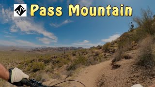
trail: Pass Mountain Trail (East)
16:15 |
233 |
Apr 25, 2025 , Apache Junction

trail: Pass Mountain Trail (East)
12:31 |
1140 |
Dec 9, 2019 , Apache Junction
youtuber
![Vicious cactus attacks mountain biker]()

trail: Pass Mountain Trail (East)
5:44 |
1534 |
Jan 11, 2019 , Apache Junction
trail: Moon Rock
0:25 |
70 |
Jan 18, 2023
Recent Trail Reports
| status | trail | date | condition | info | user |
|---|---|---|---|---|---|
| Desert Hawk Trail | Jun 12, 2026 @ 7:46am (America/Phoenix) Jun 12, 2026 | Very Dry | Daveygee | ||
| Lost Sheep Trail | Jun 12, 2026 @ 7:46am (America/Phoenix) Jun 12, 2026 | Very Dry | Daveygee | ||
| Chainfruit Trail | Jun 12, 2026 @ 7:46am (America/Phoenix) Jun 12, 2026 | Very Dry | Daveygee | ||
| Site 10 Connector | Jun 12, 2026 @ 7:46am (America/Phoenix) Jun 12, 2026 | Very Dry | Daveygee | ||
| Noso | Jun 12, 2026 @ 7:46am (America/Phoenix) Jun 12, 2026 | Very Dry | Daveygee | ||
| Channel Loop Connector | Jun 12, 2026 @ 7:46am (America/Phoenix) Jun 12, 2026 | Very Dry | Daveygee | ||
| Ruidoso | Jun 12, 2026 @ 7:46am (America/Phoenix) Jun 12, 2026 | Very Dry | Daveygee | ||
| Levee | Jun 5, 2026 @ 7:58am (America/Phoenix) Jun 5, 2026 | Very Dry | Daveygee | ||
| Blevins | Jun 5, 2026 @ 7:58am (America/Phoenix) Jun 5, 2026 | Very Dry | Daveygee | ||
| County Line | Jun 5, 2026 @ 7:58am (America/Phoenix) Jun 5, 2026 | Very Dry | Daveygee |
Activity Feed
| username | action | type | title | date |
|---|---|---|---|---|
| EdamamiRoll | wishlist | route | activity #97009218 | Jun 14, 2026 @ 3:32pm Jun 14, 2026 |
| Daveygee | add | report | activity #96822431 and 6 more | Jun 12, 2026 @ 12:43pm Jun 12, 2026 |
| Tribigsky | ridden | route | activity #96775014 | Jun 11, 2026 @ 6:15pm Jun 11, 2026 |
| Daveygee | add | report | activity #96310844 and 5 more | Jun 5, 2026 @ 11:28am Jun 5, 2026 |
| Daveygee | add | report | activity #95128607 and 7 more | May 20, 2026 @ 1:01pm May 20, 2026 |
Recent Comments
| username | type | title | comment | date |
|---|---|---|---|---|
| trail | I really enjoyed this trail especially going... | Jan 30, 2026 @ 6:13pm Jan 30, 2026 | ||
| trail | Bowhead Reach goes | Jan 30, 2026 @ 6:19am Jan 30, 2026 | ||
| trail | Bowhead reach goes between the talons. ... | Jan 17, 2026 @ 8:42am Jan 17, 2026 | ||
| trail | Bowhead Reach goes | Jan 17, 2026 @ 8:42am Jan 17, 2026 | ||
| trail | Bowhead Reach goes | Jan 17, 2026 @ 8:41am Jan 17, 2026 |
Nearby Areas
| name | distance | ||||
|---|---|---|---|---|---|
| Desert Arroyo Park | 2 | 2 km | |||
| Brown Mountain | 3 | 3 km | |||
| Bulldog Canyon OHV Area | 3.3 km | ||||
| Hawes | 21 | 36 | 22 | 6 | 4.4 km |
| Tonto NF - Apache Junction | 2 | 1 | 2 | 4.6 km |
Local Badges
-

Completionist0 awarded
Activity Type Stats
| activitytype | trails | distance | descent | descent distance | total vertical | rating | global rank | state rank | photos | reports | routes | ridelogs |
|---|---|---|---|---|---|---|---|---|---|---|---|---|
| Mountain Bike | 49 | 50 miles | 5,423 ft | 25 miles | 1,926 ft | #604 | #218 | 305 | 1,560 | 18 | 33,023 | |
| E-Bike | 42 | 45 miles | 4,505 ft | 23 miles | 1,926 ft | #2,462 | #811 | 4 | 1,390 | 1 | 1,383 | |
| Horse | 13 | 15 miles | 1,604 ft | 7 miles | 1,896 ft | #1,215 | #622 | 204 | 160 | |||
| Hike | 55 | 54 miles | 5,663 ft | 26 miles | 1,926 ft | #1,316 | #628 | 13 | 1,558 | 1 | 3,107 | |
| Trail Running | 55 | 54 miles | 5,663 ft | 26 miles | 1,926 ft | #2,498 | #613 | 1,558 | 4 | 3,244 |
Frequently Asked Questions About Usery Mountains
▼
What are the highest rated mountain biking trails in Usery Mountains?
The highest rated mountain biking trails in Usery Mountains are:
- Lost Sheep Trail (4.4/5)
- Chainfruit Trail (4.3/5)
- Talon (South) (4.2/5)
- Moon Rock (4.1/5)
- Cat Peaks (East) (4/5)
▼
What is the best time of the year to ride in Usery Mountains?
Based on ride log data, the most popular months to ride in Usery Mountains are:
- April (362 activities)
- February (355 activities)
- November (354 activities)
▼
Where can I park to ride in Usery Mountains?
▼
What is the longest trail in Usery Mountains?
The longest trail in Usery Mountains is Pass Mountain Trail (East) at 4.4 miles. View all trails sorted by distance.
Activities
- By todd
 Trailforks & contributors
 - Admins: apply
- #5002 - 23,643 views
- usery mountains activity log | embed map of Usery Mountains mountain bike trails | usery mountains mountain biking points of interest polygons
Downloading of trail gps tracks in kml & gpx formats is enabled for Usery Mountains.
You must login to download files.