close
-
Layers w
- Weather Layers
- Pro
- Pro
- Pro
- Pro
- Pro
- Pro
- More Layers
- Pro
- Pro
- Pro
- Pro
-
Upgrade to

3D
Trail Conditions
- Unknown
- Snow Groomed
- Snow Packed
- Snow Covered
- Snow Cover Partial
- Freeze/thaw Cycle
- Icy
- Prevalent Mud
- Wet
- Variable
- Ideal
- Dry
- Very Dry
Trail Flow (Ridden Direction)
Trailforks scans users ridelogs to determine the most popular direction each trail is ridden. A good flowing trail network will have most trails flowing in a single direction according to their intension.
The colour categories are based on what percentage of riders are riding a trail in its intended direction.
The colour categories are based on what percentage of riders are riding a trail in its intended direction.
- > 96%
- > 90%
- > 80%
- > 70%
- > 50%
- < 50%
- bi-directional trail
- no data
Trail Last Ridden
Trailforks scans ridelogs to determine the last time a trail was ridden.
- < 2 days
- < 1 week
- < 2 weeks
- < 1 month
- < 6 months
- > 6 months
Trail Ridden Direction
The intended direction a trail should be ridden.
- Downhill Only
- Downhill Primary
- Both Directions
- Uphill Primary
- Uphill Only
- One Direction
Contribute Details
Colors indicate trail is missing specified detail.
- Description
- Photos
- Description & Photos
- Videos
Trail Popularity ?
Trailforks scans ridelogs to determine which trails are ridden the most in the last 9 months.
Trails are compared with nearby trails in the same city region with a possible 25 colour shades.
Think of this as a heatmap, more rides = more kinetic energy = warmer colors.
- most popular
- popular
- less popular
- not popular
ATV/ORV/OHV Filter
Max Vehicle Width
inches
US Cell Coverage
Legend

Radar Time
Activity Recordings
Trailforks uses anonymized public activity data.
?
Activity Recordings
Trailforks uses anonymized public activity data.
?
Personal Heatmap
▶
Activity Types
all
/
none
▶
Options
2
Date range
month
–
Winter Trails
Warning
A routing network for winter maps does not exist. Selecting trails using the winter trails layer has been disabled.
Missing Trails
Most Popular
Least Popular
Trails are colored based on popularity. The more popular a trail is, the more red. Less popular trails trend towards green.
Jump Magnitude Heatmap
Heatmap of where riders jump on trails. Zoom in to see individual jumps, click circles to view jump details.
BC Backroad Status
![map legend]()
Service Road Atlas is a free to use, community-driven service for viewing and creating reports on the numerous back-country service roads around B.C. and Alberta.

Slope Aspect
Direction the slope faces
Trails Deemphasized
Trails are shown in grey.
Only show trails with no bike usage.
Suggested Layers
Based on selected activity type
Save the current map location and zoom level as your default home location whenever this page is loaded.
Save
No description for Ustka has been added yet!
Login or register to submit one.
This region uses the Uk/Euro style trail grading system.
Activities Click to view
- Mountain Bike
13 trails
- E-Bike
7 trails
- Winter Fat Bike
0 trails
- Horse
0 trails
- Hike
12 trails
- Trail Running
12 trails
- Observed Trials
0 trails
- Snowshoe
0 trails
- Downhill Ski
0 trails
- Backcountry Ski
0 trails
- Nordic Ski
0 trails
Region Details
- 4
- 5
- 4
Region Status
Open as of May 3, 2026Stats
- Avg Trail Rating
- Trails (view details)
- 13
- Trails Mountain Bike
- 13
- Trails E-Bike
- 7
- Trails Hike
- 12
- Trails Trail Running
- 12
- Total Distance
- 21 miles
- Total Descent Distance
- 9 miles
- Total Descent
- 749 ft
- Total Vertical
- 128 ft
- Highest Trailhead
- 134 ft
- Reports
- 23
- Photos
- 7
- Ridden Counter
- 349
Popular Ustka Mountain Biking Trails
• 95 ★ 4.4 • 4 miles • 144 ft • 59 • • hike
Ta ścieżka to w 99% czerwony szlak turystyczny wzdłuż wybrzeża. Jak to nad morzem, dużo piasku, choć także dużo utwardzonej drogi. Miejscami prowadzi po klifach - piękne widoki na morze. Przejezdna rowerem, ale męcząca ze...
• 85 ★ 0.0 • 2 miles • 33 ft • 50 • • hike
Łatwy, dojazd z Rowów do Dębowej góry. Względnie szeroka, leśna, nieutwardzona ścieżka. Miejscami można znaleźć korzenie lub trochę piachu.
• 80 ★ 4.5 • 4,619 ft • 46 ft • 27 •
Bardziej dziki wariant trasy " ". Więcej piachu, krzaków i węższe ścieżki. Miejscami pokrywa się z " " i " ". Często biegnie kilka / kilkanaście metrów od ww tras, więc wymaga uwagi, aby nie zjechać na "prostszą" trasę....
• 35 ★ 4.0 • 1,637 ft • 34 ft • 14 •
Less popular blue difficulty singletrack. This mountain bike primary trail can be used both directions. On average it takes 1 minutes to complete this trail.
• 25 ★ 0.0 • 3 miles • 158 ft • 10 • • hike
Naturalny singletrack, poprowadzony po koronie klifu nad samym morzem, o nawierzchni mineralno-piaszczystej poprzecinanej sekcjami korzeni.
• 65 ★ 0.0 • 4,547 ft • 43 ft • 9 •
Moderately popular green difficulty family friendly singletrack. This mountain bike primary trail can be used both directions. On average it takes 7 minutes to complete this trail.
• 5 ★ 0.0 • 4,396 ft • 50 ft • 3 • • hike
Ścieżka dydaktyczna przez Wydmę Orzechowską. Wybitnie piesza, szczególnie ze względu na masę drewnianych schodów, które trzeba pokonać. Rowerowo: przez część trasy wpychanie roweru po schodach, reszta trasy przez las dość...
• 5 ★ 4.0 • 2,802 ft • 29 ft • 2 •
Less popular blue difficulty singletrack. This mountain bike primary trail can be used both directions. Trail visibility is sometimes hard to follow.
Ustka Mountain Bike Routes
15 miles • 211 ft • 0 • Loop •
Pętla startująca z Surf Camp koło Garna Mała. Dalej Szlakiem Zwiniętych Torów do Bałamątek. Potem...
Videos of Ustka Mountain Bike
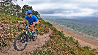
trail: Piaskowe Klify 1
4:41 |
223 |
Oct 20, 2022 , Ustka
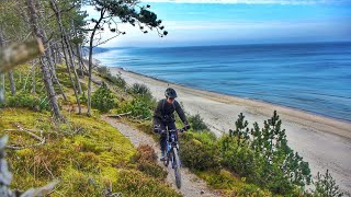
trail: Piaskowe Klify 3
4:08 |
222 |
Apr 23, 2022 , Ustka

trail: Piaskowe Klify 2
4:08 |
104 |
Apr 23, 2022 , Ustka

trail: Piaskowe Klify 1
4:08 |
140 |
Apr 22, 2022 , Ustka
Recent Trail Reports
| status | trail | date | condition | info | user |
|---|---|---|---|---|---|
| Nadmorski | Dec 6, 2025 @ 10:39am (Europe/Kaliningrad) Dec 6, 2025 | Ideal | R62 | ||
| Wydma Orzechowska | Dec 6, 2025 @ 10:39am (Europe/Kaliningrad) Dec 6, 2025 | Ideal | R62 | ||
| Zwinięte Tory | Jul 12, 2025 @ 11:45am Jul 12, 2025 | Ideal | kocbar | ||
| Obwodnica Wydmy Orzechowskiej | Jul 12, 2025 @ 11:45am Jul 12, 2025 | Variable | kocbar | ||
| Orzechowo - Poddąbie | Jun 13, 2025 @ 3:57pm Jun 13, 2025 | Unknown | quezak | ||
| Piaskowe Klify 2 | Aug 15, 2022 @ 12:07pm Aug 15, 2022 | Variable | xaoo WE | ||
| Piaskowe Klify 3 | Aug 15, 2022 @ 9:27am Aug 15, 2022 | Variable | xaoo WE | ||
| Dębowa Góra | Aug 14, 2022 @ 12:30pm Aug 14, 2022 | Dry | xaoo WE | ||
| Dębowy Access | Jul 6, 2021 @ 7:48am Jul 6, 2021 | Very Dry | jarwilgarmin | ||
| Piaskowe Klify 1 | Nov 21, 2018 @ 7:15am Nov 21, 2018 | Dry | mfica |
Activity Feed
| username | action | type | title | date |
|---|---|---|---|---|
| R62 | add | report | activity #85218077 and 1 more | Dec 6, 2025 @ 8:54am Dec 6, 2025 |
| kocbar | add | report | activity #76183618 and 1 more | Jul 18, 2025 @ 2:39pm Jul 18, 2025 |
| zhirandell | comment | trail | activity #75580373 and 1 more | Jul 10, 2025 @ 3:54am Jul 10, 2025 |
| quezak | add | report | activity #74025340 | Jun 18, 2025 @ 2:01am Jun 18, 2025 |
| kajetan1 | update | region | activity #52385372 | May 10, 2024 @ 3:40pm May 10, 2024 |
Recent Comments
| username | type | title | comment | date |
|---|---|---|---|---|
| trail | Sporo powalonych drzew, trzeba przenosić rower. | Jul 10, 2025 @ 6:14am Jul 10, 2025 | ||
| trail | W chwili obecnej ścieżka w takiej formie nie... | Jul 10, 2025 @ 3:54am Jul 10, 2025 | ||
| trail | I definetly want to check it | Jun 13, 2020 @ 12:12pm Jun 13, 2020 |
Local Badges
-

Epic Mountain Bike Climb 2k7 awarded -

Climbing 10k Badge0 awarded -

Mountain Biking 100k Badge0 awarded -

Epic Ride Descent 2k7 awarded -

Descent 10k Badge0 awarded -

Descent 100k Badge0 awarded
Activity Type Stats
| activitytype | trails | distance | descent | descent distance | total vertical | rating | global rank | state rank | photos | reports | routes | ridelogs |
|---|---|---|---|---|---|---|---|---|---|---|---|---|
| Mountain Bike | 13 | 21 miles | 748 ft | 9 miles | 128 ft | #7,790 | #211 | 7 | 23 | 1 | 1,267 | |
| E-Bike | 7 | 14 miles | 512 ft | 6 miles | 98 ft | #5,066 | #371 | 22 | 1 | 15 | ||
| Hike | 12 | 21 miles | 745 ft | 8 miles | 128 ft | #6,838 | #129 | 23 | 208 | |||
| Trail Running | 12 | 21 miles | 745 ft | 8 miles | 128 ft | #6,658 | #133 | 23 | 13 |
Frequently Asked Questions About Ustka
▼
What are the highest rated mountain biking trails in Ustka?
The highest rated mountain biking trails in Ustka are:
- Piaskowe Klify 1 (4.1/5)
- Nadmorski (4.1/5)
- Piaskowe Klify 3 (4/5)
- Piaskowe Klify 2 (4/5)
- Dębowy Access (0/5)
▼
What is the best time of the year to ride in Ustka?
Based on ride log data, the most popular months to ride in Ustka are:
- August (25 activities)
- July (21 activities)
- June (7 activities)
▼
Where can I park to ride in Ustka?
Check the Ustka trail map for trailhead and parking information. Community members regularly update access and parking details for trails in the area.
▼
What is the longest trail in Ustka?
The longest trail in Ustka is Nadmorski at 4.3 miles. View all trails sorted by distance.
Activities
Trails
Points of Interest
- By maciek1998
 & contributors
 - Admins: apply
- #14647 - 2,416 views
- ustka activity log | embed map of Ustka mountain bike trails | ustka mountain biking points of interest
Downloading of trail gps tracks in kml & gpx formats is enabled for Ustka.
You must login to download files.