close
-
Layers w
- Weather Layers
- Pro
- Pro
- Pro
- Pro
- Pro
- Pro
- More Layers
- Pro
- Pro
- Pro
- Pro
-
Upgrade to

3D
Trail Conditions
- Unknown
- Snow Groomed
- Snow Packed
- Snow Covered
- Snow Cover Partial
- Freeze/thaw Cycle
- Icy
- Prevalent Mud
- Wet
- Variable
- Ideal
- Dry
- Very Dry
Trail Flow (Ridden Direction)
Trailforks scans users ridelogs to determine the most popular direction each trail is ridden. A good flowing trail network will have most trails flowing in a single direction according to their intension.
The colour categories are based on what percentage of riders are riding a trail in its intended direction.
The colour categories are based on what percentage of riders are riding a trail in its intended direction.
- > 96%
- > 90%
- > 80%
- > 70%
- > 50%
- < 50%
- bi-directional trail
- no data
Trail Last Ridden
Trailforks scans ridelogs to determine the last time a trail was ridden.
- < 2 days
- < 1 week
- < 2 weeks
- < 1 month
- < 6 months
- > 6 months
Trail Ridden Direction
The intended direction a trail should be ridden.
- Downhill Only
- Downhill Primary
- Both Directions
- Uphill Primary
- Uphill Only
- One Direction
Contribute Details
Colors indicate trail is missing specified detail.
- Description
- Photos
- Description & Photos
- Videos
Trail Popularity ?
Trailforks scans ridelogs to determine which trails are ridden the most in the last 9 months.
Trails are compared with nearby trails in the same city region with a possible 25 colour shades.
Think of this as a heatmap, more rides = more kinetic energy = warmer colors.
- most popular
- popular
- less popular
- not popular
ATV/ORV/OHV Filter
Max Vehicle Width
inches
US Cell Coverage
Legend

Radar Time
Activity Recordings
Trailforks uses anonymized public activity data.
?
Activity Recordings
Trailforks uses anonymized public activity data.
?
Personal Heatmap
▶
Activity Types
all
/
none
▶
Options
2
Date range
month
–
Winter Trails
Warning
A routing network for winter maps does not exist. Selecting trails using the winter trails layer has been disabled.
Missing Trails
Most Popular
Least Popular
Trails are colored based on popularity. The more popular a trail is, the more red. Less popular trails trend towards green.
Jump Magnitude Heatmap
Heatmap of where riders jump on trails. Zoom in to see individual jumps, click circles to view jump details.
BC Backroad Status
![map legend]()
Service Road Atlas is a free to use, community-driven service for viewing and creating reports on the numerous back-country service roads around B.C. and Alberta.

Slope Aspect
Direction the slope faces
Trails Deemphasized
Trails are shown in grey.
Only show trails with no bike usage.
Suggested Layers
Based on selected activity type
Save the current map location and zoom level as your default home location whenever this page is loaded.
SaveStats
- Avg Trail Rating
- Trails (view details)
- 11,239
- Trails Mountain Bike
- 7,531
- Trails E-Bike
- 3,979
- Trails Gravel Bike
- 1,193
- Trails Adaptive Bike
- 1,423
- Trails Winter Fat Bike
- 624
- Trails Horse
- 2,319
- Trails Hike
- 8,345
- Trails Trail Running
- 8,056
- Trails Dirtbike/Moto
- 1,756
- Trails Observed Trials
- 88
- Trails ATV/ORV/OHV
- 1,319
- Trails Snowmobile
- 475
- Trails Snowshoe
- 399
- Trails Downhill Ski
- 1,785
- Trails Backcountry Ski
- 47
- Trails Nordic Ski
- 265
- Total Distance
- 17,105 miles
- Total Descent
- 3,049,613 ft
- Total Vertical
- 13,411 ft
- Highest Trailhead
- 13,517 ft
- Reports
- 121,071
- Photos
- 36,734
- Ridden Counter
- 3,739,033
Articles
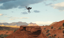
Video: Johny Salido Returns to Utah to Fight for a Red Bull Rampage Spot
Jun 4, 2026 from pinkbike.com
Johny Salido heads back to the desert in "No Man's Land" to prove he belongs on the world's heaviest freeride stage.
Video: Breakout Freeride Star Alessio Tonoli Carves His Own Line in the Utah Desert
Jun 2, 2026 from pinkbike.com
"84779" follows the Swiss pinner and his crew as they hunt for natural features, carry water, and blend heavy BMX flair with rugged desert terrain.

Binge Watch: Dennis Enarson’s Massive 15-Episode 'Game of Bike' Tournament
May 26, 2026 from pinkbike.com
Dennis delivers an epic 16-rider bracket gauntlet at COR Park. Watch the entire tournament shake out from round one to the finals.
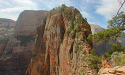
Hiker Dies After Fall from Angels Landing in Zion National Park
Apr 18, 2026 from backpacker.com
Several trails in Zion closed for recovery operations following the incident, which appears to be the first fatality on Angels Landing since 2024.
Popular Trail Networks
view all areas »Sub Regions
- Beaver County (127)
- Ephraim Canyon (0)
- Garfield County (65)
- Grand County (544)
- Iron County (197)
- Kane County (98)
- Northern Utah (771)
- Box Elder County (7)
- Cache County (156)
- Davis County (216)
- Morgan County (15)
- Riche County (4)
- Weber County (328)
- Salt Lake County (864)
- Jordan River Parkway (17)
- San Juan County (65)
- Sanpete County (0)
- Sanpete-Emery-Carbon (232)
- Sevier County (38)
- Southern Utah (581)
- Summit County (606)
- Kamas Valley (33)
- Tooele County (68)
- Tushar Mountains (86)
- Uintas (96)
- Utah County (1,710)
- Wasatch County (355)
Popular Utah Mountain Biking Trails
• 95 ★ 4.2 • 2 miles • 227 ft • 14,893 •
This is one of the main trails in Park City; it traverses across the entire range from Deer Valley to CMR to Canyons Ski Resort. It generally at elevations between 8,200' and 8,400' with lots of smaller ups and downs, but generally...
• 100 ★ 4.6 • 11 miles • 202 ft • 11,810 •
bike trail is one of the must ride biking trails of Moab, Utah. Long pedal up form town but best when shuttled to the top. On the bike map it is often combined as the with , , and . The main bike trail is about 18KM long with a gentle...
• 100 ★ 4.6 • 1,411 ft • 5 ft • 10,962 •
connects to the world-famous . Together these two trails make up the lower section of the Whole Enchilada Trail System. provides a Slickrock playground, progressing into brief patches of flow trail sections coupled with ledges, sharp...
• 100 ★ 4.6 • 4,465 ft • 35 ft • 10,253 •
4th ride of the . Singletrack starts at a right fork off of the . Watch for the map sign. The double track, which is the , continues to the left and intersects the Sand Flats Road. Challenging singletrack over rock, roots, ledges, and...
• 100 ★ 4.6 • 4,488 ft • 0 ft • 10,101 •
Highly rated popular black diamond difficulty singletrack. This mountain bike primary trail can be used downhill primary. On average it takes 8 minutes to complete this trail.
• 100 ★ 4.3 • 1,906 ft • 24 ft • 9,740 •
This is an alternate to the crazy-hard "notch" that has a few super-tight switchbacks but less steep sections.
• 100 ★ 4.9 • 4,514 ft • 3 ft • 9,677 •
This trail is the cherry on top when riding ! Amazing views of Castle valley are afforded after 50 meters of riding. The trail has good flow with some spicy sections. There is some pedalling but no uphill sections. The exposed rock...
• 100 ★ 4.8 • 2 miles • 145 ft • 8,347 •
Jewel of the area, relatively new to the other trails. Fun transitions and some great little rock drops. is a bit easier, so if you are unsure of your skill, start there, and then climb back up to do .
Utah Mountain Bike Routes
Thunder Mountain Shuttle Yourself Featured
★ 3.8 • 15 miles • 1,767 ft • 2 • Loop •
This is the most common way to ride . There is a small percentage of people that like to ride it as an...
Vertigo Loop Featured
★ 4.9 • 4 miles • 577 ft • 4 •
This is a really nice easy spin up, nothing too steep, and a pretty smooth climb. It puts you right at the...
Flying Glenwild Dog Loop Featured
★ 4.3 • 16 miles • 1,981 ft • 6 • Loop •
If you are going to tackle Park City and you are starting from the north end, this is a must do loop. The...
Red Fleet Ultimate Featured
★ 5.0 • 8 miles • 1,138 ft • 7 • Loop •
Favorite loop in the area. Starts off pretty easy and flowy with some ups and downs and fast flow sections...
The Real Mighty 5 Featured
★ 4.2 • 28 miles • 5,122 ft • 22 • Loop •
This is the ultimate downhill day at Corner Canyon. This route never uses the same piece of singletrack...
Aquarius Route Featured
★ 3.7 • 196 miles • 17,172 ft • 10 • Point to Point •
The Greatest Bicycle Adventure in the American West. Welcome to Utah’s Color Country, one of the...
Photos of Utah Mountain Bike
Videos of Utah Mountain Bike
trail: 11zs
4:01 |
5 |
Jun 5, 2026
trail: Lower Spinal Tap
0:07 |
32 |
May 24, 2026
trail: Cutlers Express
0:11 |
4 |
May 18, 2026
trail: Holladay
0:16 |
4 |
May 17, 2026
trail: Apollo
0:56 |
7 |
May 9, 2026
trail: Hog Rider (Skilz Line)
0:26 |
7 |
May 9, 2026
trail: Brownstone
0:41 |
8 |
May 8, 2026
trail: Belly Wash
2:01 |
6 |
May 8, 2026
National Scenic Trails & Official Routes
-
Bonneville Shoreline Trail
- Mountain Bike
- E-Bike
- Horse
- Hike
- Trail Running
- Snowshoe
- Nordic Ski
-
Great Western Trail
- Mountain Bike
- E-Bike
- Horse
- Hike
- Trail Running
- Dirtbike/Moto
- ATV/ORV/OHV


Activity Feed
| username | action | type | title | date |
|---|---|---|---|---|
| Scubby1 | add | report | activity #97236064 | Jun 18, 2026 @ 12:19am 4 hours |
| slewandowski | wishlist | region | activity #97232733 | Jun 17, 2026 @ 10:15pm 6 hours |
| RachelIBkOIb | wishlist | route | activity #97232357 | Jun 17, 2026 @ 10:00pm 6 hours |
| Bngayan | ridden | trail | activity #97231040 and 1 more | Jun 17, 2026 @ 9:14pm 7 hours |
| Baldkat82 | ridden | trail | activity #97230245 | Jun 17, 2026 @ 8:49pm 7 hours |
Recent Comments
| username | type | title | comment | date |
|---|---|---|---|---|
| trail | Still washed out and unavailable from the... | Jun 17, 2026 @ 8:07pm 8 hours | ||
| trail | I guess we’re leaving a review every June... | Jun 17, 2026 @ 4:02pm 12 hours | ||
| trail | Good time, prepare for a few rock drops and... | Jun 17, 2026 @ 2:32pm 13 hours | ||
| trail | You need to be a really strong climber and not... | Jun 17, 2026 @ 12:50pm 15 hours | ||
| trail | Yes, it’s not for riding up and very... | Jun 17, 2026 @ 9:15am 19 hours |
Local Badges
-

Completionist4 awarded -
UC Bike 10 Black4,777 awarded -
UTCO Bike 10016,961 awarded -
UC Bike 10 Blue23,502 awarded -
UC Bike 10 Green13,545 awarded -

Utah County BST Bike0 awarded
Bike & Skill Parks
| name | type | city | rating |
|---|---|---|---|
| Deer Valley Resort | bike park | Park City | |
| Trailside Park | bike park | Park City | |
| Brian Head Resort | bike park | Brian Head | |
| Woodward Park City | bike park | Park City | |
| Eagle Point Resort | bike park | Beaver |
Upcoming Local Events
Activity Type Stats
| activitytype | trails | distance | descent | descent distance | total vertical | rating | global rank | state rank | photos | reports | routes | ridelogs |
|---|---|---|---|---|---|---|---|---|---|---|---|---|
| Mountain Bike | 7,531 | 12,844 miles | 1,764,908 ft | 5,527 miles | 12,034 ft | #4 | 32,174 | 120,149 | 1,953 | 2,108,412 | ||
| E-Bike | 3,979 | 7,214 miles | 852,198 ft | 3,045 miles | 11,325 ft | #3 | 443 | 99,630 | 194 | 120,832 | ||
| Gravel Bike | 1,193 | 2,106 miles | 193,241 ft | 824 miles | 8,409 ft | #4 | 13 | 12,720 | 45 | 5,218 | ||
| Adaptive Bike | 1,423 | 2,350 miles | 211,909 ft | 953 miles | 8,455 ft | #5 | 15 | 26,498 | 20 | 235 | ||
| Winter Fat Bike | 624 | 1,394 miles | 158,681 ft | 584 miles | 8,802 ft | #8 | 8 | 8,834 | 2 | 607 | ||
| Horse | 2,319 | 6,217 miles | 849,426 ft | 2,552 miles | 12,566 ft | #6 | 468 | 31,264 | 44 | 437 | ||
| Hike | 8,345 | 15,024 miles | 2,108,579 ft | 6,220 miles | 13,412 ft | #5 | 2,944 | 116,162 | 1,141 | 264,179 | ||
| Trail Running | 8,056 | 14,308 miles | 1,994,386 ft | 5,933 miles | 12,884 ft | #5 | 184 | 116,031 | 1,130 | 192,639 | ||
| Dirtbike/Moto | 1,756 | 5,404 miles | 604,327 ft | 2,266 miles | 11,325 ft | #4 | 274 | 26,363 | 42 | 6,689 | ||
| Observed Trials | 88 | 195 miles | 20,449 ft | 75 miles | 7,484 ft | #7 | 9 | 455 | 661 | |||
| ATV/ORV/OHV | 1,319 | 4,477 miles | 434,360 ft | 1,843 miles | 11,325 ft | #2 | 62 | 25,453 | 23 | 1,568 | ||
| Snowmobile | 475 | 796 miles | 88,652 ft | 305 miles | 11,138 ft | #9 | 15 | 418 | 11 | 387 | ||
| Snowshoe | 399 | 448 miles | 57,021 ft | 151 miles | 6,503 ft | #22 | 14 | 5,289 | 269 | 4,109 | ||
| Downhill Ski | 1,785 | 717 miles | 728,547 ft | 680 miles | 5,751 ft | #4 | 5 | 1,069 | 123,890 | |||
| Backcountry Ski | 47 | 72 miles | 12,710 ft | 26 miles | 6,503 ft | #9 | 1,481 | 5 | 58,996 | |||
| Nordic Ski | 265 | 202 miles | 17,221 ft | 79 miles | 5,719 ft | #23 | 7 | 3,057 | 3 | 23,785 |
Activities
- Utah Mountain Biking Trails
- Utah E-Biking Trails
- Utah Gravel Biking Trails
- Utah Adaptive Biking Trails
- Utah Winter Fat Biking Trails
- Utah Horseback Trails
- Utah Hiking Trails
- Utah Trail Running Trails
- Utah Dirtbiking Trails
- Utah Observed Trials Trails
- Utah ATVing/Offroading Trails
- Utah Snowmobiling Trails
- Utah Snowshoeing Trails
- Utah Skiing Trails
- Utah Backcountry Skiing Trails
- Utah Nordic Skiing Trails
Trails
Points of Interest
- Halfway Stage House Sight
- Three peaks loop ladder bridge TTF
- Hook and Ladder Information
- Sand Flats Entrance Station Information
- Kane Creek Petroglyphs Sight
- Hummer Hill Information
- Day Canyon Overlook Viewpoint
- Goonie Bird Rock Sight
- Tusher Tunnel Sight
- The Jug Handle Sight
- Mount Emmons (13,419 ft)
- Painter Peak (13,346 ft)
- Second Gemini (13,297 ft)
- By canadaka
 Trailforks & contributors
 - Admins: Map Team, IMBA, chuktA, msmcfate, WillieJacobsz, PlumbBobM, ReckitRolley, colinreuter, jkwilliamz, UtahJohn
- #3142 - 422,985 views
- utah activity log | embed map of Utah mountain bike trails | utah mountain biking points of interest polygons
Downloading of trail gps tracks in kml & gpx formats is enabled for Utah.
You must login to download files.