close
-
Layers w
- Weather Layers
- Pro
- Pro
- Pro
- Pro
- Pro
- Pro
- More Layers
- Pro
- Pro
- Pro
- Pro
-
Upgrade to

3D
Trail Conditions
- Unknown
- Snow Groomed
- Snow Packed
- Snow Covered
- Snow Cover Partial
- Freeze/thaw Cycle
- Icy
- Prevalent Mud
- Wet
- Variable
- Ideal
- Dry
- Very Dry
Trail Flow (Ridden Direction)
Trailforks scans users ridelogs to determine the most popular direction each trail is ridden. A good flowing trail network will have most trails flowing in a single direction according to their intension.
The colour categories are based on what percentage of riders are riding a trail in its intended direction.
The colour categories are based on what percentage of riders are riding a trail in its intended direction.
- > 96%
- > 90%
- > 80%
- > 70%
- > 50%
- < 50%
- bi-directional trail
- no data
Trail Last Ridden
Trailforks scans ridelogs to determine the last time a trail was ridden.
- < 2 days
- < 1 week
- < 2 weeks
- < 1 month
- < 6 months
- > 6 months
Trail Ridden Direction
The intended direction a trail should be ridden.
- Downhill Only
- Downhill Primary
- Both Directions
- Uphill Primary
- Uphill Only
- One Direction
Contribute Details
Colors indicate trail is missing specified detail.
- Description
- Photos
- Description & Photos
- Videos
Trail Popularity ?
Trailforks scans ridelogs to determine which trails are ridden the most in the last 9 months.
Trails are compared with nearby trails in the same city region with a possible 25 colour shades.
Think of this as a heatmap, more rides = more kinetic energy = warmer colors.
- most popular
- popular
- less popular
- not popular
ATV/ORV/OHV Filter
Max Vehicle Width
inches
US Cell Coverage
Legend

Radar Time
Activity Recordings
Trailforks uses anonymized public activity data.
?
Activity Recordings
Trailforks uses anonymized public activity data.
?
Personal Heatmap
▶
Activity Types
all
/
none
▶
Options
2
Date range
month
–
Winter Trails
Warning
A routing network for winter maps does not exist. Selecting trails using the winter trails layer has been disabled.
Missing Trails
Most Popular
Least Popular
Trails are colored based on popularity. The more popular a trail is, the more red. Less popular trails trend towards green.
Jump Magnitude Heatmap
Heatmap of where riders jump on trails. Zoom in to see individual jumps, click circles to view jump details.
BC Backroad Status
![map legend]()
Service Road Atlas is a free to use, community-driven service for viewing and creating reports on the numerous back-country service roads around B.C. and Alberta.

Slope Aspect
Direction the slope faces
Trails Deemphasized
Trails are shown in grey.
Only show trails with no bike usage.
Suggested Layers
Based on selected activity type
Save the current map location and zoom level as your default home location whenever this page is loaded.
Save
No description for Vaalwater has been added yet!
Login or register to submit one.
Activities Click to view
- Mountain Bike
283 trails
- E-Bike
272 trails
- Gravel Bike
0 trails
- Adaptive Bike
0 trails
- Winter Fat Bike
0 trails
- Hike
302 trails
- Trail Running
302 trails
Region Details
- 146
- 60
- 54
- 5
- 4
Region Status
Open as of May 25, 2026Stats
- Avg Trail Rating
- Trails (view details)
- 303
- Trails Mountain Bike
- 284
- Trails E-Bike
- 272
- Trails Hike
- 302
- Trails Trail Running
- 302
- Total Distance
- 341 miles
- Total Descent Distance
- 174 miles
- Total Descent
- 28,475 ft
- Total Vertical
- 1,475 ft
- Highest Trailhead
- 5,285 ft
- Reports
- 222
- Photos
- 103
- Ridden Counter
- 6,552
Sub Regions
-
Izintaba Private Game Reserve
-
Lindani Game & Lodges
- 15
- 24
- 3
- 3
-
Summerplace
- 45
- 30
- 2
- 1
-
Waterberg Trails Gravel Grinding Network
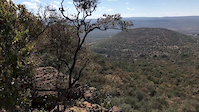
Popular Vaalwater Mountain Biking Trails
• 100 ★ 5.0 • 2,913 ft • 88 ft • 128 •
is one of the most popular trails at Summerplace. It starts on the middle Farm Road (where ends) and heads gradually towards the summit of the hill. Very gradually and with long winding sweeps through a combination of bushveld and...
• 100 ★ 0.0 • 591 ft • 25 ft • 103 •
Popular green difficulty singletrack. This multi-use trail can be used both directions and has a easy overall physical rating with a 25 ft green climb. Trail visibility is always easy to follow. On average it takes minutes to complete this trail.
• 100 ★ 5.0 • 2 miles • 131 ft • 102 •
is one of the most popular trails at Summerplace. It starts on the middle Farm Road (where ends) and heads gradually towards the summit of the hill. Very gradually and with long winding sweeps through a combination of bushveld and...
• 100 ★ 5.0 • 814 ft • 6 ft • 98 •
Popular green difficulty singletrack. This multi-use trail can be used both directions and has a easy overall physical rating with a 6 ft green climb. Trail visibility is always easy to follow. On average it takes 2 minutes to complete this trail.
• 95 ★ 5.0 • 3 miles • 273 ft • 91 •
is one of the original trails and also one of the most ridden. It starts at the Bike Village and initially heads north. It curves gradually around a ridgeline before heading east and onto a more winding section, mostly through...
• 100 ★ 5.0 • 3,911 ft • 0 ft • 77 •
Enduro Line #1 is the easiest of all our lines. This is great fun and if you have an adventurous spirit, it is worth the ride.
• 90 ★ 0.0 • 5 miles • 424 ft • 75 •
is a relatively new trail, but is fast becoming a favourite of regular Summerplace visitors. It starts at The Bike Village and heads southeast for quite some distance. There’s a bit of undulation initially before you hit a gradual...
• 90 ★ 4.5 • 3 miles • 214 ft • 73 •
is located on Hill, close to the Bike Village. It’s a singletrack trail that most can ride. With 34 metres of ascent and 38 metres of descent, it’s not flat, but it does offer good flow and allows you to hold a good speed. The...
Vaalwater Mountain Bike Routes
★ 5.0 • 83 miles • 3,027 ft • 1 • Loop •
This route consists mostly of gravel road with a few kms of tar road. This is quite a challenging route...
★ 5.0 • 36 miles • 1,120 ft • 1 • Loop •
This route consists of gravel roads and is easy riding for those who would like time in the saddle. High...
★ 5.0 • 50 miles • 1,938 ft • 0 • Loop •
This is an 80km gravel ride that is very scenic and you are sure to see game along the way. This is a...
★ 5.0 • 42 miles • 1,417 ft • 0 • Loop •
For time in the saddle you will enjoy riding these gravel roads through the Waterberg. There is no single...
Lindani - Easy 5 - Shuttle decent Featured
9 miles • 265 ft • 3 • Shuttled •
This route is for those wanting to enjoy a fun easy flowing downhill run through stunning Waterberg...
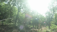
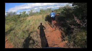
Videos of Vaalwater Mountain Bike
trail: 3 Amps via Mineshaft
0:52 |
50 |
Jun 8, 2020
trail: Roller Coaster Ravine
0:21 |
30 |
Jun 8, 2020

10:23 |
289 |
Apr 23, 2021
2:43 |
442 |
Apr 23, 2021

2:42 |
390 |
Apr 23, 2021
youtuber
![Mountain Biking In South Africa: Summerplace...]()
11:19 |
386 |
Feb 14, 2021

0:13 |
300 |
Jun 3, 2020

0:46 |
239 |
Jun 3, 2020
Recent Trail Reports
| status | trail | date | condition | info | user |
|---|---|---|---|---|---|
| Aloe Forest | Sep 27, 2025 @ 8:20am (Africa/Johannesburg) Sep 26, 2025 | Ideal | PaulsKz47Z | ||
| Salad | Sep 27, 2025 @ 8:20am (Africa/Johannesburg) Sep 26, 2025 | Ideal | PaulsKz47Z | ||
| Old School | Sep 27, 2025 @ 8:20am (Africa/Johannesburg) Sep 26, 2025 | Ideal | PaulsKz47Z | ||
| Spook Huis | Sep 27, 2025 @ 8:20am (Africa/Johannesburg) Sep 26, 2025 | Ideal | PaulsKz47Z | ||
| Savannah River Ride | Nov 12, 2023 @ 8:00pm Nov 12, 2023 | Ideal | CasperzLZEsk | ||
| Flat Rocks Rd | Nov 12, 2023 @ 8:00pm Nov 12, 2023 | Ideal | CasperzLZEsk | ||
| Topsy Turvy Link | Nov 12, 2023 @ 8:00pm Nov 12, 2023 | Ideal | CasperzLZEsk | ||
| Topsy Turvy Link | Nov 12, 2023 @ 8:00pm Nov 12, 2023 | Ideal | CasperzLZEsk | ||
| Lindani 019 | Nov 12, 2023 @ 8:00pm Nov 12, 2023 | Ideal | CasperzLZEsk | ||
| Lindani 017 | Nov 12, 2023 @ 8:00pm Nov 12, 2023 | Ideal | CasperzLZEsk |
Activity Feed
| username | action | type | title | date |
|---|---|---|---|---|
| stephenmahony | wishlist | region | activity #96238808 | Jun 4, 2026 @ 10:43am Jun 4, 2026 |
| BobBliksem | wishlist | region | activity #95914801 | May 31, 2026 @ 1:12am May 31, 2026 |
| Jcgregoire | wishlist | route | activity #95913057 and 1 more | May 31, 2026 @ 12:21am May 31, 2026 |
| Shawls | wishlist | trail | activity #94992739 | May 18, 2026 @ 12:14pm May 18, 2026 |
| cathyfivaz | wishlist | route | activity #93763651 and 12 more | May 1, 2026 @ 2:24am May 1, 2026 |
Recent Comments
| username | type | title | comment | date |
|---|---|---|---|---|
| report | If there is one trail that is a "must do" it's... | Jun 29, 2025 @ 12:04am Jun 29, 2025 | ||
| trail | Really nice but some dangerous parts you... | Dec 31, 2024 @ 8:17am Dec 31, 2024 | ||
| trail | Many many many rocks and boulders | Dec 31, 2024 @ 8:15am Dec 31, 2024 | ||
| trail | Also more black than blue | Sep 17, 2022 @ 11:23am Sep 17, 2022 | ||
| trail | This is definitely black not blue | Sep 17, 2022 @ 11:22am Sep 17, 2022 |
Local Badges
-

Completionist0 awarded -
Completionist0 awarded -

10 Blue Trails39 awarded -

Epic Mountain Bike Climb 2k6 awarded -

Climbing 10k Badge11 awarded -

Mountain Biking 100k Badge1 awarded
Bike & Skill Parks
| name | type | city | rating |
|---|---|---|---|
| Molope Bike Park | skill park | Vaalwater | |
| Waterberg MTB Skills Park | skill park | Vaalwater |
Activity Type Stats
| activitytype | trails | distance | descent | descent distance | total vertical | rating | global rank | state rank | photos | reports | routes | ridelogs |
|---|---|---|---|---|---|---|---|---|---|---|---|---|
| Mountain Bike | 283 | 321 miles | 25,423 ft | 165 miles | 1,476 ft | #538 | #12 | 75 | 222 | 67 | 3,045 | |
| E-Bike | 272 | 309 miles | 23,540 ft | 158 miles | 1,476 ft | #251 | #38 | 3 | 217 | 61 | 278 | |
| Hike | 302 | 335 miles | 27,218 ft | 170 miles | 1,476 ft | #287 | #11 | 17 | 221 | 45 | 192 | |
| Trail Running | 302 | 335 miles | 27,218 ft | 170 miles | 1,476 ft | #300 | #12 | 8 | 221 | 63 | 339 |
Frequently Asked Questions About Vaalwater
▼
What are the best places to ride in Vaalwater?
Vaalwater has 4 areas to explore for mountain biking. The top rated areas are:
▼
What are the highest rated mountain biking trails in Vaalwater?
The highest rated mountain biking trails in Vaalwater are:
- Boekenhout (4.2/5)
- Outer Route Trail (4.1/5)
- Gully Link (4.1/5)
- Bypass (4.1/5)
- Great Aloe Link (4.1/5)
▼
What is the best time of the year to ride in Vaalwater?
Based on ride log data, the most popular months to ride in Vaalwater are:
- July (21 activities)
- October (21 activities)
- September (20 activities)
▼
Where can I park to ride in Vaalwater?
There are 11 parking locations listed in Vaalwater. The most popular parking spots are:
- Waterberg MTB Parking
- Lindani Parking
- Koperspruit Trail Parking 1
- Mountain Trail (MTT) Upper Parking
- Mountain Trail (MTT) Lower Parking
Activities
Trails
- By WaterbergMTB
 Summerplace & contributors
 - Admins: apply
- #33702 - 3,049 views
- vaalwater activity log | embed map of Vaalwater mountain bike trails | vaalwater mountain biking points of interest polygons
Downloading of trail gps tracks in kml & gpx formats is enabled for Vaalwater.
You must login to download files.