close
-
Layers w
- Weather Layers
- Pro
- Pro
- Pro
- Pro
- Pro
- Pro
- More Layers
- Pro
- Pro
- Pro
- Pro
-
Upgrade to

3D
Trail Conditions
- Unknown
- Snow Groomed
- Snow Packed
- Snow Covered
- Snow Cover Partial
- Freeze/thaw Cycle
- Icy
- Prevalent Mud
- Wet
- Variable
- Ideal
- Dry
- Very Dry
Trail Flow (Ridden Direction)
Trailforks scans users ridelogs to determine the most popular direction each trail is ridden. A good flowing trail network will have most trails flowing in a single direction according to their intension.
The colour categories are based on what percentage of riders are riding a trail in its intended direction.
The colour categories are based on what percentage of riders are riding a trail in its intended direction.
- > 96%
- > 90%
- > 80%
- > 70%
- > 50%
- < 50%
- bi-directional trail
- no data
Trail Last Ridden
Trailforks scans ridelogs to determine the last time a trail was ridden.
- < 2 days
- < 1 week
- < 2 weeks
- < 1 month
- < 6 months
- > 6 months
Trail Ridden Direction
The intended direction a trail should be ridden.
- Downhill Only
- Downhill Primary
- Both Directions
- Uphill Primary
- Uphill Only
- One Direction
Contribute Details
Colors indicate trail is missing specified detail.
- Description
- Photos
- Description & Photos
- Videos
Trail Popularity ?
Trailforks scans ridelogs to determine which trails are ridden the most in the last 9 months.
Trails are compared with nearby trails in the same city region with a possible 25 colour shades.
Think of this as a heatmap, more rides = more kinetic energy = warmer colors.
- most popular
- popular
- less popular
- not popular
ATV/ORV/OHV Filter
Max Vehicle Width
inches
US Cell Coverage
Legend

Radar Time
Activity Recordings
Trailforks uses anonymized public activity data.
?
Activity Recordings
Trailforks uses anonymized public activity data.
?
Personal Heatmap
▶
Activity Types
all
/
none
▶
Options
2
Date range
month
–
Winter Trails
Warning
A routing network for winter maps does not exist. Selecting trails using the winter trails layer has been disabled.
Missing Trails
Most Popular
Least Popular
Trails are colored based on popularity. The more popular a trail is, the more red. Less popular trails trend towards green.
Jump Magnitude Heatmap
Heatmap of where riders jump on trails. Zoom in to see individual jumps, click circles to view jump details.
BC Backroad Status
![map legend]()
Service Road Atlas is a free to use, community-driven service for viewing and creating reports on the numerous back-country service roads around B.C. and Alberta.

Slope Aspect
Direction the slope faces
Trails Deemphasized
Trails are shown in grey.
Only show trails with no bike usage.
Suggested Layers
Based on selected activity type
Save the current map location and zoom level as your default home location whenever this page is loaded.
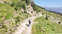
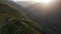
SaveEn el corazón de los Pirineos, a caballo entre Francia y España, con raíces en ambas regiones está el Val d’Aran. Uno de los pocos con orientación norte y con alrededor del 30% de su territorio por encima de los 2mil metros de altura, con varias montañas de 3mil metros. Seguramente conocerás la estación de esquí Baqueira Beret, la más grande de España y que ha sido el motor económico turístico de la región durante muchos años. Pero las cosas están cambiando y evolucionando de la mano de un grupo de locales que se literalmente están dejando la piel y el sudor para crear una red espectacular de senderos. Una localización privilegiada con un terreno espectacular y una variedad enorme con todo tipo de senderos creados por riders locales para todos los gustos.
AKA: Valle de Arán
This region uses the Uk/Euro style trail grading system.
Region Supporters & Maintainers
![]()
OcBike Val d'Aran
since 2023Sponsor![]()
Aran Bike Parks
since 2013Builder![]()
Aran Bike Parks
since 2013Maintainer
Activities Click to view
- Mountain Bike
224 trails
- E-Bike
221 trails
- Horse
6 trails
- Hike
212 trails
- Trail Running
212 trails
- Snowmobile
4 trails
- Snowshoe
4 trails
- Downhill Ski
57 trails
- Backcountry Ski
4 trails
- Nordic Ski
2 trails
Stats
- Avg Trail Rating
- Trails (view details)
- 288
- Trails Mountain Bike
- 224
- Trails E-Bike
- 221
- Trails Horse
- 6
- Trails Hike
- 212
- Trails Trail Running
- 212
- Trails Dirtbike/Moto
- 2
- Trails ATV/ORV/OHV
- 2
- Trails Snowmobile
- 4
- Trails Snowshoe
- 4
- Trails Downhill Ski
- 57
- Trails Backcountry Ski
- 4
- Trails Nordic Ski
- 2
- Total Distance
- 396 miles
- Total Descent
- 195,052 ft
- Total Vertical
- 7,313 ft
- Highest Trailhead
- 9,341 ft
- Reports
- 2,195
- Photos
- 810
- Ridden Counter
- 40,561
Sub Regions
Popular Val d'Aran Mountain Biking Trails
• 90 ★ 4.7 • 3 miles • 202 ft • 478 •
alpine trail with amazing landscapes over the Aran Valley!! 6kilometers uphill and then 4 flat kilometers in amazing trail and finish with a narrow trail. Sendero sin mucha dificultad técnica, salvo un par de pasos, pero eso si, muy,...
• 75 ★ 4.9 • 4,925 ft • 0 ft • 376 •
fun trail a little bit step. combyn roots , with rock gardens and closed turns
• 90 ★ 5.0 • 2,178 ft • 0 ft • 324 •
Highly rated popular blue difficulty singletrack. This multi-use trail can be used downhill only. It features berm. Trail visibility is always easy to follow. On average it takes 3 minutes to complete this trail.
• 95 ★ 4.8 • 2,569 ft • 0 ft • 323 •
Antic camí d'accés als prats i al bosc de Betren. Molt revirat i divertit d'inici a final.
Val d'Aran Mountain Bike Routes
★ 5.0 • 27 miles • 6,644 ft • 3 • Loop •
Great trail-enduro loop, one of the most spectacular ones that Val d’Aran has to offer. It has...
★ 5.0 • 15 miles • 3,776 ft • 4 • Loop •
A fantastic circular route that links two quite technical and fun descents and allows you to enjoy very...
8 miles • 2,107 ft • 5 • Loop •
Single trail built specifically for mountain biking. A work of craftsmanship in the forests of la Tuca,...
★ 3.5 • 24 miles • 5,222 ft • 7 • Loop •
One of the best routes you can do in Val d'Aran valley, the 12km descent is not for the faint hearted. The...
★ 3.0 • 8 miles • 2,083 ft • 1 • Loop •
En este itinerario se combina una ascensión suave pero prolongada por el bosque de Tuca con una bajada...
7 miles • 1,927 ft • 2 • Loop •
The Sanglièr descent is the first to open in the Enduromies sector and it has become a classic for many...
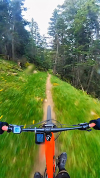
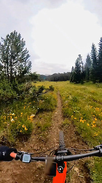
Photos of Val d'Aran Mountain Bike
Videos of Val d'Aran Mountain Bike
trail: Acceso Pruedo
0:24 |
1 |
Nov 14, 2025
trail: Cataplàs Dessús
0:23 |
|
Nov 4, 2024
trail: Pruedo
3:15 |
|
Oct 15, 2024
trail: Antenas Vielha
0:59 |
17 |
Oct 29, 2023
trail: Eth Taro
0:13 |
55 |
Sep 16, 2023
trail: Eth Sanglier
0:32 |
30 |
Sep 16, 2023

trail: Obaga Arties Gessa
0:18 |
|
Aug 13, 2023
trail: Obaga Arties Gessa
0:18 |
|
Aug 13, 2023
Current Trail Warnings
| status | trail | date | condition | user | info |
|---|---|---|---|---|---|
| Big Nuggets Vielha | May 29, 2026 @ 9:43am (Europe/Andorra) May 29, 2026 | Ideal | salvafc | Esta cerrado con multitud de pinos caidos |
Recent Trail Reports
Activity Feed
| username | action | type | title | date |
|---|---|---|---|---|
| Atzucat | wishlist | trail | activity #97306345 | Jun 19, 2026 @ 3:52am 54 mins |
| Atzucat | wishlist | trail | activity #97305771 and 1 more | Jun 19, 2026 @ 3:32am 1 hours |
| Dimass | vote | trail | activity #97235781 | Jun 18, 2026 @ 12:07am 1 day |
| Dimass | vote | trail | activity #97166653 | Jun 17, 2026 @ 12:26am 2 days |
| Dimass | ridden | trail | activity #97166637 | Jun 17, 2026 @ 12:25am 2 days |
Recent Comments
| username | type | title | comment | date |
|---|---|---|---|---|
| trail | Perfecte estat tota la pujada | May 30, 2026 @ 1:49pm May 30, 2026 | ||
| report | Sense neu ja a la part alta | May 24, 2026 @ 9:17am May 24, 2026 | ||
| report | Hola Jordi, pero es factible recuperar el trail? | Apr 26, 2026 @ 1:32am Apr 26, 2026 | ||
| report | Gracias por avisar! Deseando poder ir | Apr 25, 2026 @ 2:52pm Apr 25, 2026 | ||
| report | Por lo demás qué tal está?? | Apr 23, 2026 @ 11:56pm Apr 23, 2026 |
Local Badges
-

Descent 10k Badge31 awarded -

Big Ride 30k84 awarded -

Descent 100k Badge0 awarded -
Descent 100k Badge0 awarded -
Descent 10k Badge7 awarded -

Epic Ride Descent 2k226 awarded
Bike & Skill Parks
| name | type | city | rating |
|---|---|---|---|
| Pumptrack Arties | skill park | Salardu |
Upcoming Local Events
Local Trail Supporters
![]()
- Wilson and friends
Local Trail Association
-

Local Trail Supporters
![]()
- Wilson and friends
Local Trail Association
Activity Type Stats
| activitytype | trails | distance | descent | descent distance | total vertical | rating | global rank | state rank | photos | reports | routes | ridelogs |
|---|---|---|---|---|---|---|---|---|---|---|---|---|
| Mountain Bike | 224 | 340 miles | 145,630 ft | 184 miles | 6,142 ft | 795 | 2,195 | 50 | 9,433 | |||
| E-Bike | 221 | 338 miles | 143,566 ft | 182 miles | 6,142 ft | 11 | 2,143 | 45 | 3,498 | |||
| Horse | 6 | 22 miles | 5,364 ft | 13 miles | 3,428 ft | 150 | ||||||
| Hike | 212 | 332 miles | 143,488 ft | 179 miles | 7,313 ft | 1 | 2,006 | 1 | 1,966 | |||
| Trail Running | 212 | 332 miles | 143,488 ft | 179 miles | 7,313 ft | 1 | 2,006 | 1 | 1,159 | |||
| Dirtbike/Moto | 2 | 10 miles | 2,841 ft | 6 miles | 1,325 ft | 148 | ||||||
| ATV/ORV/OHV | 2 | 10 miles | 2,841 ft | 6 miles | 1,325 ft | 148 | 2 | |||||
| Snowmobile | 4 | 23 miles | 7,297 ft | 15 miles | 3,911 ft | 2 | ||||||
| Snowshoe | 4 | 23 miles | 7,297 ft | 15 miles | 3,911 ft | 2 | 25 | |||||
| Downhill Ski | 57 | 50 miles | 38,241 ft | 45 miles | 5,584 ft | 1 | 2 | 1,558 | ||||
| Backcountry Ski | 4 | 23 miles | 9,629 ft | 16 miles | 6,302 ft | 2 | 734 | |||||
| Nordic Ski | 2 | 12 miles | 4,455 ft | 9 miles | 3,911 ft | 2 | 383 |
Frequently Asked Questions About Val d'Aran
▼
What are the best places to ride in Val d'Aran?
Val d'Aran has 5 areas to explore for mountain biking. The top rated areas are:
▼
What are the highest rated mountain biking trails in Val d'Aran?
The highest rated mountain biking trails in Val d'Aran are:
- Big Nuggets (4.6/5)
- Eth Sanglier 2.0 (4.6/5)
- Green Rocks (4.6/5)
- Eth Sanglier (4.6/5)
- Entecada (4.6/5)
▼
What is the best time of the year to ride in Val d'Aran?
Based on ride log data, the most popular months to ride in Val d'Aran are:
- July (131 activities)
- August (127 activities)
- June (94 activities)
▼
What is the longest trail in Val d'Aran?
The longest trail in Val d'Aran is Liat-Honeria per Guerri at 5.9 miles. View all trails sorted by distance.
Activities
Trails
Points of Interest
- Refugio de Molières / Mulleres Cabin
- Refugio de Pont Rius Cabin
- Cabaña Cabin
- Cabana deth pastor Cabin
- Cabanne de campsaure Cabin
- Cabane de la Flache de Roumingau - Luchonais Cabin
- Camping Verneda
- Camping Artigané
- Val D'Aran Camperpark Camping
- Tuc de la Tallada (9,626 ft)
- Pic de Contraix (9,603 ft)
- la Creu de Colomers (9,380 ft)
- By Marcscan
 OCB & contributors
 - Admins: mul0w, elyari, AMG, juanx, Angelreing, snaker4, kai-bcn, OCB, Kalamarrrrrdo
- #15537 - 15,491 views
- val d'aran activity log | embed map of Val d'Aran mountain bike trails | val d'aran mountain biking points of interest
Downloading of trail gps tracks in kml & gpx formats is enabled for Val d'Aran.
You must login to download files.