close
-
Layers w
- Weather Layers
- Pro
- Pro
- Pro
- Pro
- Pro
- Pro
- More Layers
- Pro
- Pro
- Pro
- Pro
-
Upgrade to

3D
Trail Conditions
- Unknown
- Snow Groomed
- Snow Packed
- Snow Covered
- Snow Cover Partial
- Freeze/thaw Cycle
- Icy
- Prevalent Mud
- Wet
- Variable
- Ideal
- Dry
- Very Dry
Trail Flow (Ridden Direction)
Trailforks scans users ridelogs to determine the most popular direction each trail is ridden. A good flowing trail network will have most trails flowing in a single direction according to their intension.
The colour categories are based on what percentage of riders are riding a trail in its intended direction.
The colour categories are based on what percentage of riders are riding a trail in its intended direction.
- > 96%
- > 90%
- > 80%
- > 70%
- > 50%
- < 50%
- bi-directional trail
- no data
Trail Last Ridden
Trailforks scans ridelogs to determine the last time a trail was ridden.
- < 2 days
- < 1 week
- < 2 weeks
- < 1 month
- < 6 months
- > 6 months
Trail Ridden Direction
The intended direction a trail should be ridden.
- Downhill Only
- Downhill Primary
- Both Directions
- Uphill Primary
- Uphill Only
- One Direction
Contribute Details
Colors indicate trail is missing specified detail.
- Description
- Photos
- Description & Photos
- Videos
Trail Popularity ?
Trailforks scans ridelogs to determine which trails are ridden the most in the last 9 months.
Trails are compared with nearby trails in the same city region with a possible 25 colour shades.
Think of this as a heatmap, more rides = more kinetic energy = warmer colors.
- most popular
- popular
- less popular
- not popular
ATV/ORV/OHV Filter
Max Vehicle Width
inches
US Cell Coverage
Legend

Radar Time
Activity Recordings
Trailforks uses anonymized public activity data.
?
Activity Recordings
Trailforks uses anonymized public activity data.
?
Personal Heatmap
▶
Activity Types
all
/
none
▶
Options
2
Date range
month
–
Winter Trails
Warning
A routing network for winter maps does not exist. Selecting trails using the winter trails layer has been disabled.
Missing Trails
Most Popular
Least Popular
Trails are colored based on popularity. The more popular a trail is, the more red. Less popular trails trend towards green.
Jump Magnitude Heatmap
Heatmap of where riders jump on trails. Zoom in to see individual jumps, click circles to view jump details.
BC Backroad Status
![map legend]()
Service Road Atlas is a free to use, community-driven service for viewing and creating reports on the numerous back-country service roads around B.C. and Alberta.

Slope Aspect
Direction the slope faces
Trails Deemphasized
Trails are shown in grey.
Only show trails with no bike usage.
Suggested Layers
Based on selected activity type
Save the current map location and zoom level as your default home location whenever this page is loaded.
Save
No description for Val Sangone has been added yet!
Login or register to submit one.
 google parking directions
Primary Trail Type: Cross-Country
google parking directionsThis region uses the Uk/Euro style trail grading system.
Activities Click to view
- Mountain Bike
122 trails
- E-Bike
56 trails
- Horse
6 trails
- Hike
129 trails
- Trail Running
131 trails
- Snowshoe
2 trails
- Backcountry Ski
2 trails
Region Details
- 26
- 8
- 68
- 10
- 4
Region Status
Caution as of 2 hoursLocal Trail Association
Stats
- Avg Trail Rating
- Trails (view details)
- 129
- Trails Mountain Bike
- 122
- Trails E-Bike
- 56
- Trails Horse
- 6
- Trails Hike
- 129
- Trails Trail Running
- 131
- Trails Snowshoe
- 2
- Trails Backcountry Ski
- 2
- Total Distance
- 121 miles
- Total Descent
- 42,202 ft
- Total Vertical
- 6,843 ft
- Highest Trailhead
- 8,669 ft
- Reports
- 1,681
- Photos
- 497
- Ridden Counter
- 3,820
Popular Val Sangone Mountain Biking Trails
• 85 ★ 4.3 • 1,101 ft • 41 ft • 131 •
Popular blue difficulty singletrack. This mountain bike primary trail can be used both directions. On average it takes 3 minutes to complete this trail.
• 100 ★ 4.5 • 1,757 ft • 4 ft • 121 •
Popular blue difficulty singletrack. This mountain bike primary trail can be used both directions. On average it takes 2 minutes to complete this trail.
• 100 ★ 4.9 • 3,589 ft • 5 ft • 116 •
Highly rated popular red difficulty singletrack. This mountain bike primary trail. On average it takes 6 minutes to complete this trail.
• 100 ★ 4.8 • 2,677 ft • 24 ft • 108 •
Trail che collega pian Aschiero tramite il primo pezzo del sentiero delle macine all'inizio del sulla strada di bosco Ugo
• 95 ★ 5.0 • 3,829 ft • 0 ft • 96 •
Popular blue difficulty singletrack. This mountain bike primary trail can be used downhill only. On average it takes 5 minutes to complete this trail.
• 70 ★ 5.0 • 2,681 ft • 12 ft • 86 •
Popular blue difficulty singletrack. This mountain bike primary trail can be used downhill primary. Trail visibility is always easy to follow. On average it takes 6 minutes to complete this trail.
• 75 ★ 5.0 • 1 mile • 57 ft • 83 •
Quite a steep start on a singe track (erosion), an easy section in the wood and then another steep section ending at an old stone wall. From there multiple traces in the wood down to Pianiermo (farm, huge grass with nice view over the...
Photos of Val Sangone Mountain Bike
Videos of Val Sangone Mountain Bike

trail: Attila
8:39 |
21 |
May 20, 2026 , Coazze

trail: Attila
13:30 |
150 |
Feb 29, 2024 , Coazze
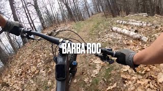
trail: Barba Roc
4:01 |
293 |
Mar 18, 2023 , My City
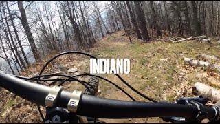
trail: L'Indiano
3:45 |
295 |
Mar 18, 2023 , Coazze
trail: Corona
12:47 |
433 |
Feb 12, 2023 , My City

trail: Villanova Flow
4:24 |
174 |
Nov 21, 2022 , My City
trail: Vernetta Classic
4:24 |
133 |
Nov 21, 2022 , Giaveno

trail: Tortorello Vernetta
4:24 |
187 |
Nov 21, 2022 , Giaveno
Current Trail Warnings
| status | trail | date | condition | user | info |
|---|---|---|---|---|---|
| Vallone Romarolo | Jun 6, 2026 @ 3:12pm (Europe/Rome) Jun 6, 2026 | Variable | silviu86 VSO | Occhio al ponticello finale, mancano due... | |
| Sentiero Pirandello Nord | May 30, 2026 @ 9:24am (Europe/Monaco) May 30, 2026 | Dry | silviu86 VSO | persiste l'albero verso la fine | |
| Colletto del Forno - Viretta | May 28, 2026 @ 10:49am (Europe/Rome) May 28, 2026 | Dry | Smudo | very bad! dont do it. really not good... |
Recent Trail Reports
| status | trail | date | condition | info | user |
|---|---|---|---|---|---|
| Vernetta Classic | Jun 21, 2026 @ 9:13am (Europe/Rome) 2 hours | Dry | tito76 | ||
| Budin DH | Jun 6, 2026 @ 3:12pm (Europe/Rome) Jun 6, 2026 | Very Dry | silviu86 VSO | ||
| Pian dei Mulè | May 30, 2026 @ 9:24am (Europe/Monaco) May 30, 2026 | Variable | silviu86 VSO | ||
| Carbonero - Quadrivio Faro | May 30, 2026 @ 9:24am (Europe/Monaco) May 30, 2026 | Ideal | silviu86 VSO | ||
| Mattonera - Carbonero | May 30, 2026 @ 9:24am (Europe/Monaco) May 30, 2026 | Dry | silviu86 VSO | ||
| Pianiermo - Mattonera | May 30, 2026 @ 9:24am (Europe/Monaco) May 30, 2026 | Ideal | silviu86 VSO | ||
| Cima Piana - Colletto Pianiermo | May 30, 2026 @ 9:24am (Europe/Monaco) May 30, 2026 | Very Dry | silviu86 VSO | ||
| Col Bione | May 30, 2026 @ 9:24am (Europe/Monaco) May 30, 2026 | Ideal | silviu86 VSO | ||
| Strada Prese delle Rose | May 30, 2026 @ 9:24am (Europe/Monaco) May 30, 2026 | Ideal | silviu86 VSO | ||
| Prese delle Rose | May 30, 2026 @ 9:24am (Europe/Monaco) May 30, 2026 | Ideal | silviu86 VSO |
Activity Feed
| username | action | type | title | date |
|---|---|---|---|---|
| tito76 | add | report | activity #97458649 | Jun 21, 2026 @ 12:13am 2 hours |
| silviu86 | add | report | activity #96405082 and 1 more | Jun 6, 2026 @ 2:07pm Jun 6, 2026 |
| silviu86 | add | report | activity #95969871 and 10 more | May 31, 2026 @ 12:49pm May 31, 2026 |
| Smudo | vote | trail | activity #95825014 | May 29, 2026 @ 11:07pm May 29, 2026 |
| Smudo | ridden | trail | activity #95825012 | May 29, 2026 @ 11:07pm May 29, 2026 |
Recent Comments
| username | type | title | comment | date |
|---|---|---|---|---|
| trail | Bellobello! | May 21, 2025 @ 12:15pm May 21, 2025 | ||
| trail | Very nice but sadly short | May 21, 2025 @ 12:14pm May 21, 2025 | ||
| trail | Parecchio foglie sulla prima parte e un albero... | Nov 4, 2024 @ 1:20am Nov 4, 2024 | ||
| trail | SENTIERO SALITA PRIMA PARTE CIRCA 1 KM SU... | Aug 11, 2024 @ 5:00am Aug 11, 2024 | ||
| trail | Not maintained, hard to bike | Jun 7, 2024 @ 7:47am Jun 7, 2024 |
Nearby Areas
| name | distance | ||||
|---|---|---|---|---|---|
| Monte Musinè | 1 | 1 | 1 | 7.5 km | |
| Val Germanasca | 11.7 km | ||||
| Prarostino | 5 | 2 | 13.3 km | ||
| Val d'Angrogna | 2 | 7 | 14.7 km | ||
| Terre del Moncenisio | 1 | 11 | 12 | 1 | 15.7 km |
Local Badges
-

Completionist0 awarded
Activity Type Stats
| activitytype | trails | distance | descent | descent distance | total vertical | rating | global rank | state rank | photos | reports | routes | ridelogs |
|---|---|---|---|---|---|---|---|---|---|---|---|---|
| Mountain Bike | 122 | 99 miles | 37,989 ft | 55 miles | 5,295 ft | #912 | #21 | 446 | 1,680 | 2,258 | ||
| E-Bike | 56 | 12 miles | 4,764 ft | 7 miles | 2,247 ft | #424 | #58 | 3 | 1,474 | 556 | ||
| Horse | 6 | 2 miles | 420 ft | 1 mile | 1,841 ft | #1,286 | #68 | 125 | ||||
| Hike | 129 | 118 miles | 41,073 ft | 61 miles | 6,844 ft | #503 | #13 | 15 | 1,655 | 410 | ||
| Trail Running | 131 | 118 miles | 41,742 ft | 62 miles | 6,844 ft | #272 | #9 | 17 | 1,673 | 104 | ||
| Snowshoe | 2 | 3,094 ft | 7 ft | 325 ft | 171 ft | #179 | #20 | 5 | 3 | |||
| Backcountry Ski | 2 | 3,094 ft | 7 ft | 325 ft | 171 ft | #196 | #19 | 1 | 33 |
Frequently Asked Questions About Val Sangone
▼
What are the highest rated mountain biking trails in Val Sangone?
The highest rated mountain biking trails in Val Sangone are:
- Pfizer Trail (4.5/5)
- Villanova Flow (4.4/5)
- La Biaviri (4.4/5)
- Canada (4.4/5)
- Pianiermo - Mattonera (4.3/5)
▼
What is the best time of the year to ride in Val Sangone?
Based on ride log data, the most popular months to ride in Val Sangone are:
- November (3 activities)
- December (1 activities)
- October (1 activities)
▼
Where can I park to ride in Val Sangone?
There are 7 parking locations listed in Val Sangone. The most popular parking spots are: View all parking and trailhead locations on the map to plan your visit.
▼
What is the longest trail in Val Sangone?
The longest trail in Val Sangone is Punta dell'Aquila at 4.5 km. View all trails sorted by distance.
Activities
Trails
- By silviu86
 VSO & contributors
 - Admins: silviu86, adessoomaipiu, VSO
- #53574 - 4,996 views
- val sangone activity log | embed map of Val Sangone mountain bike trails | val sangone mountain biking points of interest
Downloading of trail gps tracks in kml & gpx formats is enabled for Val Sangone.
You must login to download files.