close
-
Layers w
- Weather Layers
- Pro
- Pro
- Pro
- Pro
- Pro
- Pro
- More Layers
- Pro
- Pro
- Pro
- Pro
-
Upgrade to

3D
Trail Conditions
- Unknown
- Snow Groomed
- Snow Packed
- Snow Covered
- Snow Cover Partial
- Freeze/thaw Cycle
- Icy
- Prevalent Mud
- Wet
- Variable
- Ideal
- Dry
- Very Dry
Trail Flow (Ridden Direction)
Trailforks scans users ridelogs to determine the most popular direction each trail is ridden. A good flowing trail network will have most trails flowing in a single direction according to their intension.
The colour categories are based on what percentage of riders are riding a trail in its intended direction.
The colour categories are based on what percentage of riders are riding a trail in its intended direction.
- > 96%
- > 90%
- > 80%
- > 70%
- > 50%
- < 50%
- bi-directional trail
- no data
Trail Last Ridden
Trailforks scans ridelogs to determine the last time a trail was ridden.
- < 2 days
- < 1 week
- < 2 weeks
- < 1 month
- < 6 months
- > 6 months
Trail Ridden Direction
The intended direction a trail should be ridden.
- Downhill Only
- Downhill Primary
- Both Directions
- Uphill Primary
- Uphill Only
- One Direction
Contribute Details
Colors indicate trail is missing specified detail.
- Description
- Photos
- Description & Photos
- Videos
Trail Popularity ?
Trailforks scans ridelogs to determine which trails are ridden the most in the last 9 months.
Trails are compared with nearby trails in the same city region with a possible 25 colour shades.
Think of this as a heatmap, more rides = more kinetic energy = warmer colors.
- most popular
- popular
- less popular
- not popular
ATV/ORV/OHV Filter
Max Vehicle Width
inches
US Cell Coverage
Legend

Radar Time
Activity Recordings
Trailforks uses anonymized public activity data.
?
Activity Recordings
Trailforks uses anonymized public activity data.
?
Personal Heatmap
▶
Activity Types
all
/
none
▶
Options
2
Date range
month
–
Winter Trails
Warning
A routing network for winter maps does not exist. Selecting trails using the winter trails layer has been disabled.
Missing Trails
Most Popular
Least Popular
Trails are colored based on popularity. The more popular a trail is, the more red. Less popular trails trend towards green.
Jump Magnitude Heatmap
Heatmap of where riders jump on trails. Zoom in to see individual jumps, click circles to view jump details.
BC Backroad Status
![map legend]()
Service Road Atlas is a free to use, community-driven service for viewing and creating reports on the numerous back-country service roads around B.C. and Alberta.

Slope Aspect
Direction the slope faces
Trails Deemphasized
Trails are shown in grey.
Only show trails with no bike usage.
Suggested Layers
Based on selected activity type
Save the current map location and zoom level as your default home location whenever this page is loaded.
Save
No description for Valmadrera has been added yet!
Login or register to submit one.
This region uses the Uk/Euro style trail grading system.
Activities Click to view
- Mountain Bike
14 trails
- E-Bike
14 trails
- Adaptive Bike
0 trails
- Horse
4 trails
- Hike
16 trails
- Trail Running
16 trails
Region Details
- 1
- 3
- 2
- 1
- 3
- 1
Region Status
Open as of Jun 1, 2026Stats
- Avg Trail Rating
- Trails (view details)
- 15
- Trails Mountain Bike
- 14
- Trails E-Bike
- 14
- Trails Horse
- 4
- Trails Hike
- 16
- Trails Trail Running
- 16
- Total Distance
- 7 miles
- Total Descent Distance
- 4 miles
- Total Descent
- 4,001 ft
- Total Vertical
- 2,621 ft
- Highest Trailhead
- 3,300 ft
- Reports
- 73
- Photos
- 18
- Ridden Counter
- 468
Popular Valmadrera Mountain Biking Trails
• 90 ★ 4.0 • 2,333 ft • 3 ft • 23 •
The name is a certainty, don't wring the handlebar or your hand will scream for pain! Terreno prevalentemente costituito da sassi fissi e smossi. Gradoni di roccia e passaggi tecnici.
• 70 ★ 0.0 • 712 ft • 13 ft • 14 •
Short trail, from Colma di Val Ravella to Acqua del Fo'
• 60 ★ 5.0 • 889 ft • 0 ft • 14 • • hike
Funny line, steep and challenging The ground is not so disturbed as the main
• 75 ★ 3.0 • 1,444 ft • 0 ft • 12 •
, flow and with a fun jump in the middle section
• 55 ★ 4.0 • 2,418 ft • 0 ft • 11 • • hike
Hard line: steep, challenging, rocky and with disturbed ground
• 50 ★ 4.0 • 3,855 ft • 24 ft • 8 • • hike
Hard trail, with technical point and few portage
Photos of Valmadrera Mountain Bike
Videos of Valmadrera Mountain Bike
trail: San Tomaso
6:56 |
15 |
May 5, 2026 , Valmadrera
trail: Spaccabraccia Valma
11:13 |
60 |
Mar 23, 2025 , Valmadrera

trail: San Tomaso Pistino
11:13 |
84 |
Mar 23, 2025 , Valmadrera

trail: Taja sass (Taglia sassi)
11:13 |
45 |
Mar 23, 2025 , Valmadrera
trail: Spaccabraccia Valma
5:53 |
28 |
Mar 21, 2025 , Valmadrera
trail: Sentiero Sasso di Preguda
6:46 |
107 |
Jun 3, 2024 , Valmadrera
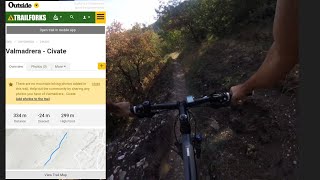
trail: Valmadrera - Civate
0:30 |
151 |
Aug 16, 2022 , Valmadrera
Recent Trail Reports
| status | trail | date | condition | info | user |
|---|---|---|---|---|---|
| San Tomaso | Jun 1, 2026 @ 10:13am (Europe/Rome) Jun 1, 2026 | Ideal | Pigisca67 | ||
| Taja sass (Taglia sassi) | Jun 1, 2026 @ 10:13am (Europe/Rome) Jun 1, 2026 | Ideal | Pigisca67 | ||
| Spaccabraccia Valma | Jan 31, 2026 @ 12:06pm (Europe/Vaduz) Jan 31, 2026 | Ideal | poporni NORTHNLINE | ||
| San Tomaso Pistino | Jan 31, 2026 @ 12:06pm (Europe/Vaduz) Jan 31, 2026 | Ideal | poporni NORTHNLINE | ||
| Val Gatton | Jan 31, 2026 @ 12:06pm (Europe/Vaduz) Jan 31, 2026 | Variable | poporni NORTHNLINE | ||
| Corno Rat | Jan 31, 2026 @ 12:06pm (Europe/Vaduz) Jan 31, 2026 | Wet | poporni NORTHNLINE | ||
| Valmadrera - Civate | Mar 17, 2025 @ 5:29pm Mar 17, 2025 | Ideal | RiccardoNoob | ||
| San Tomaso | Mar 17, 2025 @ 5:29pm Mar 17, 2025 | Variable | RiccardoNoob | ||
| Sentiero Sasso di Preguda | Jan 10, 2025 @ 10:06am Jan 10, 2025 | Ideal | edobk | ||
| Medievale | Oct 1, 2024 @ 5:57am Oct 1, 2024 | Variable | martiko |
Activity Feed
| username | action | type | title | date |
|---|---|---|---|---|
| Pigisca67 | add | report | activity #96009471 and 1 more | Jun 1, 2026 @ 4:56am Jun 1, 2026 |
| Liwena | ridden | trail | activity #95239859 | May 22, 2026 @ 7:12am May 22, 2026 |
| maooosnow | update | trail | activity #95167615 | May 21, 2026 @ 5:08am May 21, 2026 |
| RiccardoNoob | add | video | activity #94095815 | May 5, 2026 @ 9:24am May 5, 2026 |
| yentelb16 | ridden | trail | activity #93029586 and 2 more | Apr 20, 2026 @ 11:10am Apr 20, 2026 |
Recent Comments
| username | type | title | comment | date |
|---|---|---|---|---|
| report | secondo me inveci andrebbero costruiti sia... | Sep 5, 2025 @ 9:27am Sep 5, 2025 | ||
| trail | Si fa tutto in sella !!!! | Mar 19, 2025 @ 12:40pm Mar 19, 2025 | ||
| report | Feb 8, 2024 @ 6:44am Feb 8, 2024 | |||
| trail | Non adatta a rider di enduro, in numerosi... | Jun 7, 2018 @ 12:37pm Jun 7, 2018 |
Local Badges
-

Epic Mountain Bike Climb 2k2 awarded -

Climbing 10k Badge0 awarded -

Mountain Biking 100k Badge0 awarded -

Epic Ride Descent 2k2 awarded -

Descent 10k Badge0 awarded -

Descent 100k Badge0 awarded
Activity Type Stats
| activitytype | trails | distance | descent | descent distance | total vertical | rating | global rank | state rank | photos | reports | routes | ridelogs |
|---|---|---|---|---|---|---|---|---|---|---|---|---|
| Mountain Bike | 14 | 6 miles | 4,003 ft | 4 miles | 2,621 ft | #6,003 | #468 | 16 | 73 | 163 | ||
| E-Bike | 14 | 6 miles | 4,003 ft | 4 miles | 2,621 ft | #1,054 | #137 | 69 | 118 | |||
| Horse | 4 | 3 miles | 938 ft | 1 mile | 1,217 ft | #2,667 | #192 | 15 | ||||
| Hike | 16 | 7 miles | 4,003 ft | 4 miles | 2,621 ft | #8,821 | #562 | 2 | 73 | 158 | ||
| Trail Running | 16 | 7 miles | 4,003 ft | 4 miles | 2,621 ft | #9,418 | #665 | 73 | 32 |
Frequently Asked Questions About Valmadrera
▼
What are the highest rated mountain biking trails in Valmadrera?
The highest rated mountain biking trails in Valmadrera are:
- Val Gatton - variante (4.1/5)
- Corno Rat (4.1/5)
- Medievale (4.1/5)
- San Tomaso (4/5)
- Spaccabraccia Valma (4/5)
▼
Where can I park to ride in Valmadrera?
Check the Valmadrera trail map for trailhead and parking information. Community members regularly update access and parking details for trails in the area.
▼
What is the longest trail in Valmadrera?
The longest trail in Valmadrera is Sentiero Sasso di Preguda at 4,741 ft. View all trails sorted by distance.
▼
What are the best & highest rated hiking trails in Valmadrera?
The best hiking trails in Valmadrera are: View all hiking trails sorted by popularity score.
- By MatteoDeiCas
 & contributors
 - Admins: marcoangeletti, adessoomaipiu, micheletraversi, NORTHNLINE
- #25629 - 1,613 views
- valmadrera activity log | embed map of Valmadrera mountain bike trails |
Downloading of trail gps tracks in kml & gpx formats is enabled for Valmadrera.
You must login to download files.