close
-
Layers w
- Weather Layers
- Pro
- Pro
- Pro
- Pro
- Pro
- Pro
- More Layers
- Pro
- Pro
- Pro
- Pro
-
Upgrade to

3D
Trail Conditions
- Unknown
- Snow Groomed
- Snow Packed
- Snow Covered
- Snow Cover Partial
- Freeze/thaw Cycle
- Icy
- Prevalent Mud
- Wet
- Variable
- Ideal
- Dry
- Very Dry
Trail Flow (Ridden Direction)
Trailforks scans users ridelogs to determine the most popular direction each trail is ridden. A good flowing trail network will have most trails flowing in a single direction according to their intension.
The colour categories are based on what percentage of riders are riding a trail in its intended direction.
The colour categories are based on what percentage of riders are riding a trail in its intended direction.
- > 96%
- > 90%
- > 80%
- > 70%
- > 50%
- < 50%
- bi-directional trail
- no data
Trail Last Ridden
Trailforks scans ridelogs to determine the last time a trail was ridden.
- < 2 days
- < 1 week
- < 2 weeks
- < 1 month
- < 6 months
- > 6 months
Trail Ridden Direction
The intended direction a trail should be ridden.
- Downhill Only
- Downhill Primary
- Both Directions
- Uphill Primary
- Uphill Only
- One Direction
Contribute Details
Colors indicate trail is missing specified detail.
- Description
- Photos
- Description & Photos
- Videos
Trail Popularity ?
Trailforks scans ridelogs to determine which trails are ridden the most in the last 9 months.
Trails are compared with nearby trails in the same city region with a possible 25 colour shades.
Think of this as a heatmap, more rides = more kinetic energy = warmer colors.
- most popular
- popular
- less popular
- not popular
ATV/ORV/OHV Filter
Max Vehicle Width
inches
US Cell Coverage
Legend

Radar Time
Activity Recordings
Trailforks uses anonymized public activity data.
?
Activity Recordings
Trailforks uses anonymized public activity data.
?
Personal Heatmap
▶
Activity Types
all
/
none
▶
Options
2
Date range
month
–
Winter Trails
Warning
A routing network for winter maps does not exist. Selecting trails using the winter trails layer has been disabled.
Missing Trails
Most Popular
Least Popular
Trails are colored based on popularity. The more popular a trail is, the more red. Less popular trails trend towards green.
Jump Magnitude Heatmap
Heatmap of where riders jump on trails. Zoom in to see individual jumps, click circles to view jump details.
BC Backroad Status
![map legend]()
Service Road Atlas is a free to use, community-driven service for viewing and creating reports on the numerous back-country service roads around B.C. and Alberta.

Slope Aspect
Direction the slope faces
Trails Deemphasized
Trails are shown in grey.
Only show trails with no bike usage.
Suggested Layers
Based on selected activity type
Save the current map location and zoom level as your default home location whenever this page is loaded.
Save
No description for Vaughan has been added yet!
Login or register to submit one.
Activities Click to view
- Mountain Bike
160 trails
- E-Bike
35 trails
- Adaptive Bike
1 trails
- Winter Fat Bike
4 trails
- Hike
162 trails
- Trail Running
160 trails
- Snowshoe
77 trails
- Nordic Ski
31 trails
Region Details
- 60
- 26
- 46
- 20
- 6
Region Status
Open as of May 26, 2026Stats
- Avg Trail Rating
- Trails (view details)
- 165
- Trails Mountain Bike
- 160
- Trails E-Bike
- 35
- Trails Adaptive Bike
- 1
- Trails Winter Fat Bike
- 4
- Trails Hike
- 162
- Trails Trail Running
- 160
- Trails Dirtbike/Moto
- 1
- Trails Snowshoe
- 77
- Trails Nordic Ski
- 31
- Total Distance
- 87 miles
- Total Descent Distance
- 30 miles
- Total Descent
- 4,736 ft
- Total Vertical
- 545 ft
- Highest Trailhead
- 988 ft
- Reports
- 155
- Photos
- 56
- Ridden Counter
- 3,312
Sub Regions
-
Boyd Conservation Park
- 3
- 4
- 7
- 1
-
Boyd North Park
- 2
-
Cook Woodlot
- 4
-
MacMillan Nature Preserve
- 5
- 5
-
Maple Nature Reserve
- 5
- 6
-
Nashville Conservation Reserve
- 5
- 4
- 3
-
North Maple Regional Park
- 4
- 5
- 2
-
North Maple Regional Park & Forest
- 1
-
Sugarbush Heritage Park
- 5
-
Vellore Village
- 2
- 3
- 1
-
Woodrose Greenway
- 2
- 2
Popular Vaughan Mountain Biking Trails
• 100 ★ 0.0 • 4 miles • 230 ft • 103 •
Popular white difficulty family friendly gravel path. This multi-use trail can be used both directions and has a moderate overall physical rating with a 230 ft green climb. Trail visibility is always easy to follow. On average it takes 21 minutes to complete this trail.
• 100 ★ 0.0 • 3,494 ft • 43 ft • 102 •
Popular white difficulty gravel path. This multi-use trail can be used both directions. On average it takes 3 minutes to complete this trail.
• 95 ★ 0.0 • 2,090 ft • 18 ft • 50 •
Popular white difficulty mixed. This multi-use trail can be used both directions. On average it takes 2 minutes to complete this trail.
• 100 ★ 0.0 • 443 ft • 6 ft • 48 •
Popular white difficulty mixed. This multi-use trail can be used both directions. On average it takes minutes to complete this trail.
• 90 ★ 0.0 • 2,490 ft • 4 ft • 40 •
Popular white difficulty family friendly paved path. This multi-use trail can be used both directions. On average it takes 1 minutes to complete this trail.
• 80 ★ 0.0 • 3,205 ft • 85 ft • 37 •
Popular white difficulty gravel path. This multi-use trail can be used both directions and has a moderate overall physical rating with a 85 ft green climb. Trail visibility is always easy to follow. On average it takes 4 minutes to complete this trail.
• 95 ★ 0.0 • 899 ft • 74 ft • 35 •
Popular green difficulty singletrack. This multi-use trail can be used both directions. On average it takes 2 minutes to complete this trail.
• 55 ★ 0.0 • 1,545 ft • 14 ft • 34 •
Moderately popular green difficulty family friendly doubletrack. This multi-use trail can be used both directions. On average it takes 3 minutes to complete this trail.
Photos of Vaughan Mountain Bike
Videos of Vaughan Mountain Bike
trail: Ballz Of Steel
0:06 |
43 |
May 14, 2023

trail: Park
0:41 |
171 |
Nov 29, 2011
trail: Park
0:38 |
351 |
Jul 15, 2011

trail: Transition
6:48 |
1251 |
Jan 13, 2011

trail: Park
0:22 |
169 |
Aug 12, 2010

trail: Transition
0:40 |
563 |
Jul 10, 2010

trail: Park
0:40 |
619 |
Jan 29, 2010
trail: Park
0:30 |
226 |
Aug 30, 2009
Recent Trail Reports
Activity Feed
| username | action | type | title | date |
|---|---|---|---|---|
| onthemountain | ridden | trail | activity #96399230 | Jun 6, 2026 @ 12:50pm Jun 6, 2026 |
| placebo614 | checkin | trail | activity #95579267 | May 26, 2026 @ 11:34am May 26, 2026 |
| placebo614 | ridden | trail | activity #95579266 | May 26, 2026 @ 11:34am May 26, 2026 |
| placebo614 | add | report | activity #95579030 and 1 more | May 26, 2026 @ 11:31am May 26, 2026 |
| placebo614 | add | report | activity #95578978 and 9 more | May 26, 2026 @ 11:30am May 26, 2026 |
Recent Comments
| username | type | title | comment | date |
|---|---|---|---|---|
| report | It’s not there anymore don’t worry | Apr 11, 2026 @ 5:42am Apr 11, 2026 | ||
| trail | Nature has overgrown and completely blocked... | Aug 31, 2025 @ 4:13pm Aug 31, 2025 | ||
| trail | I have added a picture where it is so... | Jul 30, 2024 @ 1:13pm Jul 30, 2024 | ||
| trail | Trail is complete. Many unsanctioned off-shoots. | Oct 4, 2023 @ 9:12pm Oct 4, 2023 | ||
| trail | Forgot to mention you can reconnect to the... | Apr 25, 2022 @ 7:37am Apr 25, 2022 |
Local Badges
-

Completionist0 awarded -

10 Blue Trails9 awarded -

Epic Mountain Bike Climb 2k0 awarded -

Climbing 10k Badge7 awarded -

Mountain Biking 100k Badge0 awarded -

Epic Ride Descent 2k0 awarded
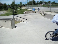
Bike & Skill Parks
| name | type | city | rating |
|---|---|---|---|
| Carrville Community Centre | skill park | Vaughan |
Activity Type Stats
| activitytype | trails | distance | descent | descent distance | total vertical | rating | global rank | state rank | photos | reports | routes | ridelogs |
|---|---|---|---|---|---|---|---|---|---|---|---|---|
| Mountain Bike | 160 | 82 miles | 4,301 ft | 28 miles | 545 ft | #2,037 | #43 | 47 | 155 | 4,597 | ||
| E-Bike | 35 | 29 miles | 955 ft | 9 miles | 525 ft | #3,888 | #70 | 102 | 76 | |||
| Adaptive Bike | 1 | #511 | #87 | 2 | ||||||||
| Winter Fat Bike | 4 | #392 | #82 | 1 | 1 | |||||||
| Hike | 162 | 85 miles | 4,656 ft | 30 miles | 545 ft | #2,183 | #51 | 5 | 146 | 660 | ||
| Trail Running | 160 | 85 miles | 4,590 ft | 29 miles | 545 ft | #1,859 | #35 | 146 | 932 | |||
| Dirtbike/Moto | 1 | 1 | ||||||||||
| Snowshoe | 77 | 36 miles | 1,949 ft | 11 miles | 525 ft | #469 | #48 | 38 | 5 | |||
| Nordic Ski | 31 | 21 miles | 997 ft | 6 miles | 525 ft | #764 | #53 | 2 | 11 |
Frequently Asked Questions About Vaughan
▼
What are the best places to ride in Vaughan?
Vaughan has 12 areas to explore for mountain biking. The top rated areas are:
▼
What are the highest rated mountain biking trails in Vaughan?
The highest rated mountain biking trails in Vaughan are:
- Connor's Wooded Meander (4.2/5)
- Pomona Mills Park Trail (4.1/5)
- Humber Valley Heritage Trail (4/5)
- Humber Valley Heritage Trail (3.8/5)
- The Wall (3.8/5)
▼
What is the best time of the year to ride in Vaughan?
Based on ride log data, the most popular months to ride in Vaughan are:
- June (50 activities)
- September (50 activities)
- July (47 activities)
▼
Where can I park to ride in Vaughan?
There are 3 parking locations listed in Vaughan. The most popular parking spots are: View all parking and trailhead locations on the map to plan your visit.
Activities
- By theprosgarage & contributors
- Admins: YMBA, YORK
- #37378 - 6,826 views
- vaughan activity log | embed map of Vaughan mountain bike trails | vaughan mountain biking points of interest
Downloading of trail gps tracks in kml & gpx formats is enabled for Vaughan.
You must login to download files.