close
-
Layers w
- Weather Layers
- Pro
- Pro
- Pro
- Pro
- Pro
- Pro
- More Layers
- Pro
- Pro
- Pro
- Pro
-
Upgrade to

3D
Trail Conditions
- Unknown
- Snow Groomed
- Snow Packed
- Snow Covered
- Snow Cover Partial
- Freeze/thaw Cycle
- Icy
- Prevalent Mud
- Wet
- Variable
- Ideal
- Dry
- Very Dry
Trail Flow (Ridden Direction)
Trailforks scans users ridelogs to determine the most popular direction each trail is ridden. A good flowing trail network will have most trails flowing in a single direction according to their intension.
The colour categories are based on what percentage of riders are riding a trail in its intended direction.
The colour categories are based on what percentage of riders are riding a trail in its intended direction.
- > 96%
- > 90%
- > 80%
- > 70%
- > 50%
- < 50%
- bi-directional trail
- no data
Trail Last Ridden
Trailforks scans ridelogs to determine the last time a trail was ridden.
- < 2 days
- < 1 week
- < 2 weeks
- < 1 month
- < 6 months
- > 6 months
Trail Ridden Direction
The intended direction a trail should be ridden.
- Downhill Only
- Downhill Primary
- Both Directions
- Uphill Primary
- Uphill Only
- One Direction
Contribute Details
Colors indicate trail is missing specified detail.
- Description
- Photos
- Description & Photos
- Videos
Trail Popularity ?
Trailforks scans ridelogs to determine which trails are ridden the most in the last 9 months.
Trails are compared with nearby trails in the same city region with a possible 25 colour shades.
Think of this as a heatmap, more rides = more kinetic energy = warmer colors.
- most popular
- popular
- less popular
- not popular
ATV/ORV/OHV Filter
Max Vehicle Width
inches
US Cell Coverage
Legend

Radar Time
Activity Recordings
Trailforks uses anonymized public activity data.
?
Activity Recordings
Trailforks uses anonymized public activity data.
?
Personal Heatmap
▶
Activity Types
all
/
none
▶
Options
2
Date range
month
–
Winter Trails
Warning
A routing network for winter maps does not exist. Selecting trails using the winter trails layer has been disabled.
Missing Trails
Most Popular
Least Popular
Trails are colored based on popularity. The more popular a trail is, the more red. Less popular trails trend towards green.
Jump Magnitude Heatmap
Heatmap of where riders jump on trails. Zoom in to see individual jumps, click circles to view jump details.
BC Backroad Status
![map legend]()
Service Road Atlas is a free to use, community-driven service for viewing and creating reports on the numerous back-country service roads around B.C. and Alberta.

Slope Aspect
Direction the slope faces
Trails Deemphasized
Trails are shown in grey.
Only show trails with no bike usage.
Suggested Layers
Based on selected activity type
Save the current map location and zoom level as your default home location whenever this page is loaded.
SaveThe mountain area offers huge potential for trails, with up to 1500 ft of vertical and acres of land.
A variety of trails are being developed around and on the hill.
A variety of trails are being developed around and on the hill.
Primary Trail Type: Cross-Country
Land Status: Private Property
Land Manager: Velo MSM
 google parking directions
 Access Info:
The main meeting point is the Velo MSM gazebo at the foot of the ski lodge. Group rides tend to begin at 10:30am on Saturday and Sunday.
Links
Activities Click to view
- Mountain Bike
61 trails
- E-Bike
31 trails
- Hike
52 trails
- Trail Running
52 trails
Region Details
- 8
- 14
- 17
- 12
- 3
- 1
Region Status
Open as of Jun 17, 2026Stats
- Avg Trail Rating
- Trails (view details)
- 55
- Trails Mountain Bike
- 64
- Trails E-Bike
- 31
- Trails Hike
- 52
- Trails Trail Running
- 52
- Total Distance
- 28 miles
- Total Descent
- 7,099 ft
- Total Vertical
- 1,331 ft
- Highest Trailhead
- 1,823 ft
- Reports
- 1,398
- Photos
- 351
- Ridden Counter
- 26,345
Popular Velo MSM Mountain Biking Trails
• 100 ★ 4.6 • 3 miles • 1,160 ft • 1,250 •
One of the premier climbing trails in all of eastern North America. An absolute must ride! Goes from the base of the Mont-Ste-Marie ski hill to the highest peak in the area, AKA the Jewel Peak.
• 95 ★ 4.8 • 2 miles • 17 ft • 1,081 •
Starts at the Jewel Peak, with lower drop in points at , and Radar. Super-fun, fast, good flow. Lots of berms and a couple bridges. Rated as a blue square, but great fun with a bit of speed.
• 70 ★ 4.3 • 1 mile • 296 ft • 828 •
Highly rated popular blue difficulty singletrack. This mountain bike primary trail can be used uphill primary and has a easy overall physical rating with a 296 ft blue climb. On average it takes 12 minutes to complete this trail.
• 70 ★ 4.3 • 2,259 ft • 107 ft • 699 •
Highly rated popular blue difficulty singletrack. This mountain bike primary trail can be used both directions. On average it takes 5 minutes to complete this trail.
• 65 ★ 4.3 • 3,801 ft • 225 ft • 692 •
Great bi-directional trail. It is a great switchback climb and a decent descent at slower speeds. It's a great way to start off a lake loop ride.
• 70 ★ 4.0 • 2,497 ft • 8 ft • 680 •
Smooth, rolling contour descent best ridden in the NASCAR direction.
• 85 ★ 4.8 • 1 mile • 29 ft • 652 •
Technical singletrack with narrow traverses and steep descents, often involving rock faces.
• 60 ★ 4.7 • 2,336 ft • 103 ft • 619 •
It may have climb in the name, but this trail is actually more fun going down!
Velo MSM Mountain Bike Routes
★ 1.7 • 6 miles • 1,381 ft • 5 •
The mountain loop. All the way to the top of the radar tower, across to the top of Vanier, and down .
★ 2.8 • 4 miles • 942 ft • 4 •
Gives a little extra riding in comparison to the regular TTOP/ loop.
6 miles • 1,318 ft • 7 • Loop •
Amazing route with technical challenges and smooth flowy sections as well
• 13 miles • 2,923 ft • 20 •
• 19 miles • 3,861 ft • 21 •
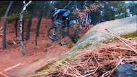
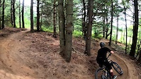
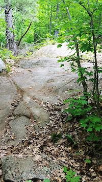
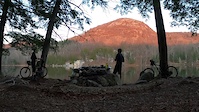
Photos of Velo MSM Mountain Bike
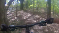
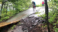
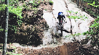
Videos of Velo MSM Mountain Bike
trail: Boneshaker
0:31 |
163 |
Mar 19, 2023
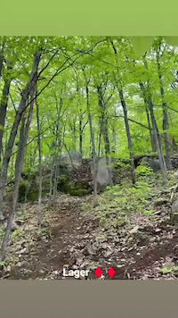
trail: Lager
0:09 |
187 |
Nov 29, 2022
trail: Angels' Bench
0:34 |
86 |
Aug 8, 2021
trail: Lager
0:18 |
251 |
Jun 3, 2021
trail: Lower Ridgeback
0:14 |
100 |
Dec 20, 2020
trail: Low Cal
2:39 |
97 |
Nov 12, 2020
trail: Boneshaker
2:17 |
393 |
Sep 20, 2020
trail: Boneshaker
0:03 |
458 |
Aug 2, 2020
Recent Trail Reports
| status | trail | date | condition | info | user |
|---|---|---|---|---|---|
| Growler | Jun 17, 2026 @ 9:41am (America/Toronto) Jun 17, 2026 | Dry | TylerDCA VMSM | ||
| Boneshaker | Jun 14, 2026 @ 11:25am (America/Toronto) Jun 14, 2026 | Ideal | TylerDCA VMSM | ||
| Cheval Connector | Jun 14, 2026 @ 11:25am (America/Toronto) Jun 14, 2026 | Ideal | TylerDCA VMSM | ||
| Family Jewel | Jun 14, 2026 @ 11:25am (America/Toronto) Jun 14, 2026 | Variable | TylerDCA VMSM | ||
| Taylor's Tower of Power | Jun 14, 2026 @ 11:25am (America/Toronto) Jun 14, 2026 | Ideal | TylerDCA VMSM | ||
| Pine Line Connector | Jun 13, 2026 @ 11:40am (America/Toronto) Jun 13, 2026 | Ideal | Cardinal1010 | ||
| Golf Course Connector 1 | Jun 13, 2026 @ 11:40am (America/Toronto) Jun 13, 2026 | Very Dry | Cardinal1010 | ||
| Pine Line | Jun 8, 2026 @ 12:13pm (America/Toronto) Jun 8, 2026 | Ideal | Cardinal1010 | ||
| Golf Course Connector 2 | Jun 8, 2026 @ 12:13pm (America/Toronto) Jun 8, 2026 | Ideal | Cardinal1010 | ||
| Groovy Grove | Jun 8, 2026 @ 12:13pm (America/Toronto) Jun 8, 2026 | Ideal | Cardinal1010 |
Activity Feed
| username | action | type | title | date |
|---|---|---|---|---|
| TylerDCA | add | report | activity #97179421 | Jun 17, 2026 @ 6:41am Jun 17, 2026 |
| TylerDCA | add | report | activity #96988204 and 3 more | Jun 14, 2026 @ 11:10am Jun 14, 2026 |
| Cardinal1010 | add | photo | activity #96896556 | Jun 13, 2026 @ 10:57am Jun 13, 2026 |
| Cardinal1010 | add | report | activity #96892323 and 1 more | Jun 13, 2026 @ 10:16am Jun 13, 2026 |
| Cardinal1010 | add | report | activity #96553157 and 5 more | Jun 8, 2026 @ 11:24am Jun 8, 2026 |
Recent Comments
| username | type | title | comment | date |
|---|---|---|---|---|
| trail | Couple fun drops before heading into Ol'... | May 18, 2026 @ 7:59am May 18, 2026 | ||
| trail | Well built trail that is an absolute riot to... | May 18, 2026 @ 7:55am May 18, 2026 | ||
| trail | Really fun trail with plenty of fun slabs and... | May 18, 2026 @ 7:53am May 18, 2026 | ||
| report | All clear | Jul 25, 2025 @ 8:39am Jul 25, 2025 | ||
| report | Trees are not large, but there are several. | Jul 4, 2025 @ 7:42am Jul 4, 2025 |
Nearby Areas
| name | distance | ||||
|---|---|---|---|---|---|
| Centre Vorlage | 7 | 2 | 4 | 20.6 km | |
| Cantley | 26.1 km | ||||
| Domaine Kanawe | 15 | 15 | 8 | 2 | 27.3 km |
| Camp Fortune | 12 | 16 | 16 | 6 | 29.6 km |
| Le Harfang | 5 | 14 | 10 | 29.7 km |
Local Badges
-

Completionist0 awarded
Bike & Skill Parks
| name | type | city | rating |
|---|---|---|---|
| Dog Pound | skill park | Lac-Sainte-Marie |
Activity Type Stats
| activitytype | trails | distance | descent | descent distance | total vertical | rating | global rank | state rank | photos | reports | routes | ridelogs |
|---|---|---|---|---|---|---|---|---|---|---|---|---|
| Mountain Bike | 61 | 28 miles | 7,100 ft | 14 miles | 1,332 ft | #478 | #13 | 334 | 1,396 | 3 | 11,088 | |
| E-Bike | 31 | 11 miles | 3,241 ft | 6 miles | 1,168 ft | #3,542 | #33 | 1,243 | 239 | |||
| Hike | 52 | 23 miles | 3,501 ft | 9 miles | 1,332 ft | #2,374 | #14 | 17 | 1,358 | 311 | ||
| Trail Running | 52 | 23 miles | 3,501 ft | 9 miles | 1,332 ft | #3,880 | #15 | 1,358 | 229 |
Frequently Asked Questions About Velo MSM
▼
What are the highest rated mountain biking trails in Velo MSM?
The highest rated mountain biking trails in Velo MSM are:
- Growler (4.7/5)
- Boneshaker (4.6/5)
- Maibock (4.6/5)
- Taylor's Tower of Power (4.5/5)
- Family Jewel (4.5/5)
▼
What is the best time of the year to ride in Velo MSM?
Based on ride log data, the most popular months to ride in Velo MSM are:
- July (258 activities)
- September (177 activities)
- August (177 activities)
▼
Where can I park to ride in Velo MSM?
There are 2 parking locations listed in Velo MSM. The most popular parking spots are:
▼
What is the longest trail in Velo MSM?
The longest trail in Velo MSM is Taylor's Tower of Power at 5.1 km. View all trails sorted by distance.
Activities
Trails
Points of Interest
- By brenthillier
 NSMBA TRAILFORKS & contributors
 - Admins: VMSM, VMSM
- #3294 - 49,623 views
- velo msm activity log | embed map of Velo MSM mountain bike trails | velo msm mountain biking points of interest
Downloading of trail gps tracks in kml & gpx formats is enabled for Velo MSM.
You must login to download files.