close
-
Layers w
- Weather Layers
- Pro
- Pro
- Pro
- Pro
- Pro
- Pro
- More Layers
- Pro
- Pro
- Pro
- Pro
-
Upgrade to

3D
Trail Conditions
- Unknown
- Snow Groomed
- Snow Packed
- Snow Covered
- Snow Cover Partial
- Freeze/thaw Cycle
- Icy
- Prevalent Mud
- Wet
- Variable
- Ideal
- Dry
- Very Dry
Trail Flow (Ridden Direction)
Trailforks scans users ridelogs to determine the most popular direction each trail is ridden. A good flowing trail network will have most trails flowing in a single direction according to their intension.
The colour categories are based on what percentage of riders are riding a trail in its intended direction.
The colour categories are based on what percentage of riders are riding a trail in its intended direction.
- > 96%
- > 90%
- > 80%
- > 70%
- > 50%
- < 50%
- bi-directional trail
- no data
Trail Last Ridden
Trailforks scans ridelogs to determine the last time a trail was ridden.
- < 2 days
- < 1 week
- < 2 weeks
- < 1 month
- < 6 months
- > 6 months
Trail Ridden Direction
The intended direction a trail should be ridden.
- Downhill Only
- Downhill Primary
- Both Directions
- Uphill Primary
- Uphill Only
- One Direction
Contribute Details
Colors indicate trail is missing specified detail.
- Description
- Photos
- Description & Photos
- Videos
Trail Popularity ?
Trailforks scans ridelogs to determine which trails are ridden the most in the last 9 months.
Trails are compared with nearby trails in the same city region with a possible 25 colour shades.
Think of this as a heatmap, more rides = more kinetic energy = warmer colors.
- most popular
- popular
- less popular
- not popular
ATV/ORV/OHV Filter
Max Vehicle Width
inches
US Cell Coverage
Legend

Radar Time
Activity Recordings
Trailforks uses anonymized public activity data.
?
Activity Recordings
Trailforks uses anonymized public activity data.
?
Personal Heatmap
▶
Activity Types
all
/
none
▶
Options
2
Date range
month
–
Winter Trails
Warning
A routing network for winter maps does not exist. Selecting trails using the winter trails layer has been disabled.
Missing Trails
Most Popular
Least Popular
Trails are colored based on popularity. The more popular a trail is, the more red. Less popular trails trend towards green.
Jump Magnitude Heatmap
Heatmap of where riders jump on trails. Zoom in to see individual jumps, click circles to view jump details.
BC Backroad Status
![map legend]()
Service Road Atlas is a free to use, community-driven service for viewing and creating reports on the numerous back-country service roads around B.C. and Alberta.

Slope Aspect
Direction the slope faces
Trails Deemphasized
Trails are shown in grey.
Only show trails with no bike usage.
Suggested Layers
Based on selected activity type
Save the current map location and zoom level as your default home location whenever this page is loaded.
Save
No description for Venzone has been added yet!
Login or register to submit one.
Links
This region uses the Uk/Euro style trail grading system.
Activities Click to view
- Mountain Bike
18 trails
- E-Bike
10 trails
- Adaptive Bike
0 trails
- Winter Fat Bike
0 trails
- Hike
16 trails
- Trail Running
16 trails
Region Details
- 5
- 3
- 5
- 4
Region Status
Open as of May 9, 2026Stats
- Avg Trail Rating
- Trails (view details)
- 18
- Trails Mountain Bike
- 18
- Trails E-Bike
- 10
- Trails Hike
- 16
- Trails Trail Running
- 16
- Total Distance
- 24 miles
- Total Descent Distance
- 9 miles
- Total Descent
- 7,716 ft
- Total Vertical
- 3,495 ft
- Highest Trailhead
- 4,307 ft
- Reports
- 24
- Photos
- 43
- Ridden Counter
- 382
Sub Regions
-
Venzonassa
- 3
- 3
- 4
Popular Venzone Mountain Biking Trails
• 100 ★ 0.0 • 2 miles • 1,158 ft • 71 •
Popular green difficulty asphalt/tarmac road. This mountain bike primary trail can be used both directions and has a hard overall physical rating with a 1,158 ft blue climb. Trail visibility is always easy to follow. On average it takes 21 minutes to complete this trail.
• 90 ★ 0.0 • 3 miles • 1,519 ft • 65 •
Popular green difficulty doubletrack. This mountain bike primary trail can be used both directions and has a hard overall physical rating with a 1,519 ft blue climb. Trail visibility is always easy to follow. On average it takes 38 minutes to complete this trail.
• 70 ★ 4.0 • 4 miles • 301 ft • 37 •
Popular red difficulty singletrack. This mountain bike primary trail can be used both directions. Trail visibility is always easy to follow. On average it takes 1 hour21 minutes to complete this trail.
• 45 ★ 0.0 • 4 miles • 1,795 ft • 35 •
Moderately popular green difficulty doubletrack. This mountain bike primary trail can be used both directions and has a hard overall physical rating with a 1,795 ft blue climb. On average it takes 43 minutes to complete this trail.
• 60 ★ 4.0 • 2 miles • 551 ft • 17 •
Moderately popular red difficulty singletrack. This mountain bike primary trail can be used both directions.
• 35 ★ 0.0 • 4,826 ft • 0 ft • 5 •
Less popular red difficulty singletrack. This mountain bike primary trail can be used downhill only.
• ★ 2.0 • 3 miles • 8 ft • 2 •
Downhill from Monte Poccet on trail CAI 601. Comment: In principle this would be a very nice DH trail from Monte Poccet and Veneziana, but it is not used often enough. There is often lots of leaves and branches on the trail....
• ★ 0.0 • 1 mile • 96 ft • 1 •
Old mulatteria trail, very nice hike a bike. This CAI 702a section is much easier compared to CAI 702 going down to Malga .
Photos of Venzone Mountain Bike
Videos of Venzone Mountain Bike
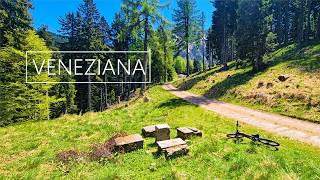
trail: Monte Poccet - Veneziana
14:31 |
8 |
May 10, 2026 , Venzone
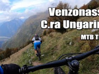
trail: Ungarina trail
120 |
Jun 25, 2025 , Venzone

9:57 |
302 |
Oct 21, 2021 , Venzone

9:57 |
302 |
Oct 21, 2021 , Venzone
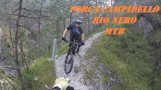
trail: Malga Confin/Ungarina
9:57 |
294 |
Oct 21, 2021 , Venzone
Recent Trail Reports
| status | trail | date | condition | info | user |
|---|---|---|---|---|---|
| Monte Poccet - Veneziana | May 9, 2026 @ 7:29pm (Europe/Rome) May 9, 2026 | Variable | agvlt | ||
| Ungarina trail | May 4, 2026 @ 2:15pm (Europe/Rome) May 4, 2026 | Dry | EmanuelxuMaH0 | ||
| Forcella Tacia climb (Tratto 1) | Apr 28, 2026 @ 3:26pm (Europe/Rome) Apr 28, 2026 | Unknown | Lambdo | ||
| Forcella Tacia climb (Tratto 2) | Apr 28, 2026 @ 3:25pm (Europe/Rome) Apr 28, 2026 | Unknown | Lambdo | ||
| SS13 - Sella Bieliga | Mar 15, 2026 @ 6:31pm (Europe/Rome) Mar 15, 2026 | Variable | agvlt | ||
| Forcella Tacia climb (Tratto 3) | Sep 6, 2021 @ 1:15am Sep 6, 2021 | Ideal | Grisenut |
Activity Feed
| username | action | type | title | date |
|---|---|---|---|---|
| feentz | wishlist | trail | activity #96980263 | Jun 14, 2026 @ 9:51am Jun 14, 2026 |
| raffaelemtb | ridden | trail | activity #96729727 | Jun 11, 2026 @ 5:06am Jun 11, 2026 |
| kohlex | ridden | trail | activity #95691624 | May 28, 2026 @ 1:06am May 28, 2026 |
| ProfessorTrail | ridden | trail | activity #95331130 | May 23, 2026 @ 10:06am May 23, 2026 |
| Danielo7 | ridden | trail | activity #95107376 | May 20, 2026 @ 7:44am May 20, 2026 |
Recent Comments
| username | type | title | comment | date |
|---|---|---|---|---|
| trail | Wenn man bereit ist eine Trage/Schiebepassage... | May 4, 2026 @ 5:12am May 4, 2026 | ||
| trail | tolle umgebung und wirklich teilweise sehr... | May 1, 2026 @ 1:05pm May 1, 2026 | ||
| trail | Sentiero con del potenziale ma lasciato molto... | Apr 28, 2021 @ 9:15am Apr 28, 2021 |
Activity Type Stats
| activitytype | trails | distance | descent | descent distance | total vertical | rating | global rank | state rank | photos | reports | routes | ridelogs |
|---|---|---|---|---|---|---|---|---|---|---|---|---|
| Mountain Bike | 18 | 24 miles | 7,717 ft | 9 miles | 3,494 ft | #6,529 | #516 | 43 | 24 | 171 | ||
| E-Bike | 10 | 18 miles | 6,722 ft | 7 miles | 3,494 ft | #5,211 | #505 | 21 | 25 | |||
| Hike | 16 | 19 miles | 3,930 ft | 6 miles | 2,733 ft | #7,994 | #472 | 15 | 29 | |||
| Trail Running | 16 | 19 miles | 3,930 ft | 6 miles | 2,733 ft | #7,620 | #466 | 15 | 16 |
Frequently Asked Questions About Venzone
▼
What are the best places to ride in Venzone?
Venzone has 1 areas to explore for mountain biking. The top rated areas are:
▼
What are the highest rated mountain biking trails in Venzone?
The highest rated mountain biking trails in Venzone are:
- Ungarina trail (4/5)
- Verzan (4/5)
- Monte Poccet - Veneziana (3.7/5)
- Forcella Tacia climb (Tratto 1) (0/5)
- Forcella Tacia climb (Tratto 2) (0/5)
▼
What is the best time of the year to ride in Venzone?
Based on ride log data, the most popular months to ride in Venzone are:
- November (2 activities)
- June (1 activities)
- October (1 activities)
▼
Where can I park to ride in Venzone?
Check the Venzone trail map for trailhead and parking information. Community members regularly update access and parking details for trails in the area.
Activities
Trails
Points of Interest
- By maxmisdaris
 MGNR & contributors
 - Admins: maxmisdaris
- #41527 - 1,296 views
- venzone activity log | embed map of Venzone mountain bike trails |
Downloading of trail gps tracks in kml & gpx formats is enabled for Venzone.
You must login to download files.