close
-
Layers w
- Weather Layers
- Pro
- Pro
- Pro
- Pro
- Pro
- Pro
- More Layers
- Pro
- Pro
- Pro
- Pro
-
Upgrade to

3D
Trail Conditions
- Unknown
- Snow Groomed
- Snow Packed
- Snow Covered
- Snow Cover Partial
- Freeze/thaw Cycle
- Icy
- Prevalent Mud
- Wet
- Variable
- Ideal
- Dry
- Very Dry
Trail Flow (Ridden Direction)
Trailforks scans users ridelogs to determine the most popular direction each trail is ridden. A good flowing trail network will have most trails flowing in a single direction according to their intension.
The colour categories are based on what percentage of riders are riding a trail in its intended direction.
The colour categories are based on what percentage of riders are riding a trail in its intended direction.
- > 96%
- > 90%
- > 80%
- > 70%
- > 50%
- < 50%
- bi-directional trail
- no data
Trail Last Ridden
Trailforks scans ridelogs to determine the last time a trail was ridden.
- < 2 days
- < 1 week
- < 2 weeks
- < 1 month
- < 6 months
- > 6 months
Trail Ridden Direction
The intended direction a trail should be ridden.
- Downhill Only
- Downhill Primary
- Both Directions
- Uphill Primary
- Uphill Only
- One Direction
Contribute Details
Colors indicate trail is missing specified detail.
- Description
- Photos
- Description & Photos
- Videos
Trail Popularity ?
Trailforks scans ridelogs to determine which trails are ridden the most in the last 9 months.
Trails are compared with nearby trails in the same city region with a possible 25 colour shades.
Think of this as a heatmap, more rides = more kinetic energy = warmer colors.
- most popular
- popular
- less popular
- not popular
ATV/ORV/OHV Filter
Max Vehicle Width
inches
US Cell Coverage
Legend

Radar Time
Activity Recordings
Trailforks uses anonymized public activity data.
?
Activity Recordings
Trailforks uses anonymized public activity data.
?
Personal Heatmap
▶
Activity Types
all
/
none
▶
Options
2
Date range
month
–
Winter Trails
Warning
A routing network for winter maps does not exist. Selecting trails using the winter trails layer has been disabled.
Missing Trails
Most Popular
Least Popular
Trails are colored based on popularity. The more popular a trail is, the more red. Less popular trails trend towards green.
Jump Magnitude Heatmap
Heatmap of where riders jump on trails. Zoom in to see individual jumps, click circles to view jump details.
BC Backroad Status
![map legend]()
Service Road Atlas is a free to use, community-driven service for viewing and creating reports on the numerous back-country service roads around B.C. and Alberta.

Slope Aspect
Direction the slope faces
Trails Deemphasized
Trails are shown in grey.
Only show trails with no bike usage.
Suggested Layers
Based on selected activity type
Save the current map location and zoom level as your default home location whenever this page is loaded.
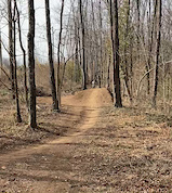
SaveVeterans Park is a the main place to ride in Lexington and is a great place for a zippy cross country ride or a skills sesh with the bros on our jump lines. With about 14 miles of trails and endless combinations of the trails you can have an extended ride, run or hike out here so come one out
Primary Trail Type: Cross-Country
eBikes Allowed:
Yes
Land Status: City Managed
Land Manager: Lexington Parks and Recreation
 google parking directions
 Activities Click to view
- Mountain Bike
17 trails
- E-Bike
18 trails
- Hike
18 trails
- Trail Running
18 trails
Region Details
- 13
- 2
Region Status
Caution as of May 8, 2026Stats
- Avg Trail Rating
- Trails (view details)
- 15
- Trails Mountain Bike
- 18
- Trails E-Bike
- 18
- Trails Hike
- 18
- Trails Trail Running
- 18
- Total Distance
- 8 miles
- Total Descent Distance
- 2 miles
- Total Descent
- 336 ft
- Total Vertical
- 89 ft
- Highest Trailhead
- 969 ft
- Reports
- 189
- Photos
- 19
- Ridden Counter
- 2,200
Popular Veterans Park Mountain Biking Trails
• 45 ★ 3.8 • 2 miles • 106 ft • 212 •
is the backbone of Veteran's Park mountain bike trails and starts with a fun, flowy downhill section beginning at Shelter 3 (you will see the kiosk/sign). As it works it's way through the park, you can hop onto or connect to any other...
• 95 ★ 5.0 • 630 ft • 0 ft • 188 •
Okay, we stepped our chef game from . We now present you with a 4 course meal carefully crafted to delight your tires. We begin our dining experience with berms big enough to ride horizontal on. From here, we transition on to our...
• 60 ★ 4.0 • 1,785 ft • 12 ft • 168 •
Trust us, we would have LOVED to call this trail something different but the name was so accurate it stuck......like Kentucky mud. This trail just loves to stay muddy all year round and thus keep the trail stewards pissed off all year...
• 85 ★ 4.0 • 2,694 ft • 24 ft • 162 •
is aptly named with big berms, big smiles, and always a touch of mud (hey, we're working on it). This trail will take you to the back of the park which we like to call Mt. Vets...or as much of a mount as you can get round here. This is...
• 80 ★ 5.0 • 4,564 ft • 40 ft • 154 •
Popular green difficulty singletrack. This mountain bike primary trail can be used both directions and has a moderate overall physical rating with a 40 ft green climb. Trail visibility is always easy to follow. On average it takes 7 minutes to complete this trail.
• 75 ★ 4.0 • 3,704 ft • 17 ft • 147 •
Some would call Veterans Park a rainforest but we decided to be a bit more honest and call it what it is, a swamp. But who says you can't have fun in a swamp (besides 95% of the population)? WE DO! Rather than tame this wild beast, we...
Veterans Park Mountain Bike Routes
6 miles • 352 ft • 3 • Loop •
Enter the park next to the tank, drive up to the top of the hill and park at one of the two shelters. The...
Photos of Veterans Park Mountain Bike
Videos of Veterans Park Mountain Bike
trail: 100 Proof
0:10 |
198 |
Dec 6, 2022
Recent Trail Reports
| status | trail | date | condition | info | user |
|---|---|---|---|---|---|
| Fish Sticks | Aug 8, 2025 @ 7:39pm Aug 8, 2025 | Dry | PaulAR10Vr | ||
| Juice Box | Aug 8, 2025 @ 7:39pm Aug 8, 2025 | Ideal | PaulAR10Vr | ||
| Mudslick | Aug 8, 2025 @ 7:39pm Aug 8, 2025 | Dry | PaulAR10Vr | ||
| Lower Narrows | Aug 8, 2025 @ 7:39pm Aug 8, 2025 | Dry | PaulAR10Vr | ||
| Deer Run | Aug 8, 2025 @ 7:39pm Aug 8, 2025 | Variable | PaulAR10Vr | ||
| Upper Narrows | Aug 8, 2025 @ 7:39pm Aug 8, 2025 | Dry | PaulAR10Vr | ||
| 100 Proof | Aug 8, 2025 @ 7:39pm Aug 8, 2025 | Dry | PaulAR10Vr | ||
| Up Trail | Aug 8, 2025 @ 7:39pm Aug 8, 2025 | Dry | PaulAR10Vr | ||
| Fine Dining | Aug 8, 2025 @ 7:39pm Aug 8, 2025 | Dry | PaulAR10Vr | ||
| Sloppy Flow | Aug 8, 2025 @ 7:39pm Aug 8, 2025 | Dry | PaulAR10Vr |
Activity Feed
| username | action | type | title | date |
|---|---|---|---|---|
| kathysgeek | add | report | activity #94273031 | May 8, 2026 @ 12:17pm May 8, 2026 |
| joshtalboo | wishlist | region | activity #93728319 | Apr 30, 2026 @ 12:16pm Apr 30, 2026 |
| Rynwind | wishlist | route | activity #91739668 | Apr 1, 2026 @ 6:41pm Apr 1, 2026 |
| joshtalboo | update | region | activity #90806996 | Mar 18, 2026 @ 10:31am Mar 18, 2026 |
| joshtalboo | add | directory | activity #90806965 | Mar 18, 2026 @ 10:30am Mar 18, 2026 |
Recent Comments
| username | type | title | comment | date |
|---|---|---|---|---|
| report | Great day to ride. Firm, not muddy but some... | Nov 2, 2019 @ 7:16pm Nov 2, 2019 |
Nearby Areas
| name | distance | ||||
|---|---|---|---|---|---|
| Deer Haven Park | 5 | 7.5 km | |||
| Life Adventure Center | 4 | 11 | 18.6 km | ||
| Anderson Dean Community Park | 21 km | ||||
| Anderson County Community Park | 22.7 km | ||||
| Capitol View Park | 8 | 10 | 1 | 25.4 km |
Activity Type Stats
| activitytype | trails | distance | descent | descent distance | total vertical | rating | global rank | state rank | photos | reports | routes | ridelogs |
|---|---|---|---|---|---|---|---|---|---|---|---|---|
| Mountain Bike | 17 | 8 miles | 338 ft | 2 miles | 89 ft | #3,017 | #1,048 | 15 | 193 | 1 | 4,009 | |
| E-Bike | 18 | 8 miles | 338 ft | 2 miles | 89 ft | #7,079 | #2,049 | 4 | 180 | 1 | 81 | |
| Hike | 18 | 8 miles | 338 ft | 2 miles | 89 ft | #12,798 | #5,357 | 193 | 1 | 100 | ||
| Trail Running | 18 | 8 miles | 338 ft | 2 miles | 89 ft | #12,183 | #4,843 | 193 | 1 | 78 |
Frequently Asked Questions About Veterans Park
▼
What are the highest rated mountain biking trails in Veterans Park?
The highest rated mountain biking trails in Veterans Park are:
- 100 Proof (4.6/5)
- Fine Dining (4.5/5)
- Deer Run (4.2/5)
- Up Trail (4.1/5)
- Upper Narrows (4.1/5)
▼
What is the best time of the year to ride in Veterans Park?
Based on ride log data, the most popular months to ride in Veterans Park are:
- August (53 activities)
- September (52 activities)
- October (35 activities)
▼
Where can I park to ride in Veterans Park?
There are 4 parking locations listed in Veterans Park. The most popular parking spots are: View all parking and trailhead locations on the map to plan your visit.
▼
What is the longest trail in Veterans Park?
The longest trail in Veterans Park is Jetstream at 1.5 miles. View all trails sorted by distance.
Activities
- By jeickelman & contributors
- Admins: KyMBA-BG
- #17841 - 8,620 views
- veterans park activity log | embed map of Veterans Park mountain bike trails | veterans park mountain biking points of interest
Downloading of trail gps tracks in kml & gpx formats is enabled for Veterans Park.
You must login to download files.