close
-
Layers w
- Weather Layers
- Pro
- Pro
- Pro
- Pro
- Pro
- Pro
- More Layers
- Pro
- Pro
- Pro
- Pro
-
Upgrade to

3D
Trail Conditions
- Unknown
- Snow Groomed
- Snow Packed
- Snow Covered
- Snow Cover Partial
- Freeze/thaw Cycle
- Icy
- Prevalent Mud
- Wet
- Variable
- Ideal
- Dry
- Very Dry
Trail Flow (Ridden Direction)
Trailforks scans users ridelogs to determine the most popular direction each trail is ridden. A good flowing trail network will have most trails flowing in a single direction according to their intension.
The colour categories are based on what percentage of riders are riding a trail in its intended direction.
The colour categories are based on what percentage of riders are riding a trail in its intended direction.
- > 96%
- > 90%
- > 80%
- > 70%
- > 50%
- < 50%
- bi-directional trail
- no data
Trail Last Ridden
Trailforks scans ridelogs to determine the last time a trail was ridden.
- < 2 days
- < 1 week
- < 2 weeks
- < 1 month
- < 6 months
- > 6 months
Trail Ridden Direction
The intended direction a trail should be ridden.
- Downhill Only
- Downhill Primary
- Both Directions
- Uphill Primary
- Uphill Only
- One Direction
Contribute Details
Colors indicate trail is missing specified detail.
- Description
- Photos
- Description & Photos
- Videos
Trail Popularity ?
Trailforks scans ridelogs to determine which trails are ridden the most in the last 9 months.
Trails are compared with nearby trails in the same city region with a possible 25 colour shades.
Think of this as a heatmap, more rides = more kinetic energy = warmer colors.
- most popular
- popular
- less popular
- not popular
ATV/ORV/OHV Filter
Max Vehicle Width
inches
US Cell Coverage
Legend

Radar Time
Activity Recordings
Trailforks uses anonymized public activity data.
?
Activity Recordings
Trailforks uses anonymized public activity data.
?
Personal Heatmap
▶
Activity Types
all
/
none
▶
Options
2
Date range
month
–
Winter Trails
Warning
A routing network for winter maps does not exist. Selecting trails using the winter trails layer has been disabled.
Missing Trails
Most Popular
Least Popular
Trails are colored based on popularity. The more popular a trail is, the more red. Less popular trails trend towards green.
Jump Magnitude Heatmap
Heatmap of where riders jump on trails. Zoom in to see individual jumps, click circles to view jump details.
BC Backroad Status
![map legend]()
Service Road Atlas is a free to use, community-driven service for viewing and creating reports on the numerous back-country service roads around B.C. and Alberta.

Slope Aspect
Direction the slope faces
Trails Deemphasized
Trails are shown in grey.
Only show trails with no bike usage.
Suggested Layers
Based on selected activity type
Save the current map location and zoom level as your default home location whenever this page is loaded.
Savevielha es la capital del Valle de Aran. desde Vielha podemos acceder a diferentes zonas como el val d'aran mountain bikepark o a los trails de pom&rola, y escunhau.
This region uses the Uk/Euro style trail grading system.
Activities Click to view
- Mountain Bike
130 trails
- E-Bike
129 trails
- Gravel Bike
0 trails
- Adaptive Bike
0 trails
- Hike
125 trails
- Trail Running
125 trails
Region Details
- 38
- 10
- 47
- 23
- 11
Region Status
Caution as of 3 daysStats
- Avg Trail Rating
- Trails (view details)
- 135
- Trails Mountain Bike
- 130
- Trails E-Bike
- 129
- Trails Hike
- 125
- Trails Trail Running
- 125
- Total Distance
- 166 miles
- Total Descent
- 81,922 ft
- Total Vertical
- 7,269 ft
- Highest Trailhead
- 9,341 ft
- Reports
- 1,279
- Photos
- 394
- Ridden Counter
- 16,676
Sub Regions
-
Camins Quate Lòcs
-
Es Bordes trails
- 1
- 3
- 8
- 1
-
Val d'Aran Mountain Bikepark
- 3
- 6
- 3
- 1
Popular Vielha Mountain Biking Trails
• 90 ★ 5.0 • 2,178 ft • 0 ft • 324 •
Highly rated popular blue difficulty singletrack. This multi-use trail can be used downhill only. It features berm. Trail visibility is always easy to follow. On average it takes 3 minutes to complete this trail.
• 95 ★ 4.8 • 2,569 ft • 0 ft • 323 •
Antic camí d'accés als prats i al bosc de Betren. Molt revirat i divertit d'inici a final.
• 95 ★ 4.2 • 3,045 ft • 0 ft • 301 •
Camí vell d'Aubèrt cap al plan batalher NO ES UN TRAIL PARA BIKE. ES UN CAMINO DE ANDAR. NO FORMA PARTE DEL BIKEPARK. ABSTENERSE DE BAJAR EN FINES DE SEMANA , PUENTES Y VACACIONES DE VERANO.
• 95 ★ 4.7 • 3,986 ft • 0 ft • 289 •
Trail con mucha hoja suelta. Primera sección con algo de pendiente y un par de pasos más comprometidos pero fáciles de losas. Algunas curvas cerradas, pocas, diferentes trazadas y última parte muy rápida y ancha.
Vielha Mountain Bike Routes
★ 5.0 • 15 miles • 3,776 ft • 4 • Loop •
A fantastic circular route that links two quite technical and fun descents and allows you to enjoy very...
8 miles • 2,107 ft • 5 • Loop •
Single trail built specifically for mountain biking. A work of craftsmanship in the forests of la Tuca,...
★ 3.5 • 24 miles • 5,222 ft • 7 • Loop •
One of the best routes you can do in Val d'Aran valley, the 12km descent is not for the faint hearted. The...
★ 3.0 • 8 miles • 2,083 ft • 1 • Loop •
En este itinerario se combina una ascensión suave pero prolongada por el bosque de Tuca con una bajada...
24 miles • 6,898 ft • 13 • Loop •
If you have a whole day to ride in the surroundings of Vielha, this is your route. There are climbs of all...
15 miles • 4,404 ft • 7 • Point to Point •
Buena ruta para combinar dos buenos trails de Viella. Primeramente subiremos a la Solana para coger un...
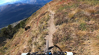
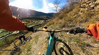
Photos of Vielha Mountain Bike
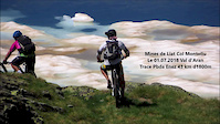
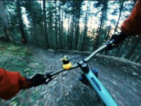
Videos of Vielha Mountain Bike
trail: Cataplàs Dessús
0:23 |
|
Nov 4, 2024
trail: Antenas Vielha
0:59 |
17 |
Oct 29, 2023
trail: Marrades de Cròdos
0:09 |
|
Oct 30, 2021
trail: Montoliu
9:08 |
474 |
Jul 5, 2018
trail: Cataplas Inferior
8:46 |
41 |
Nov 24, 2025 , Vielha

trail: Cataplàs Dessús
8:46 |
52 |
Nov 24, 2025 , Vielha
trail: Big Nuggets
5:30 |
50 |
Nov 24, 2025 , Vielha

Current Trail Warnings
| status | trail | date | condition | user | info |
|---|---|---|---|---|---|
| Big Nuggets | May 29, 2026 @ 9:43am (Europe/Andorra) May 29, 2026 | Ideal | salvafc | Esta cerrado con multitud de pinos caidos |
Recent Trail Reports
| status | trail | date | condition | info | user |
|---|---|---|---|---|---|
| Carretèra de Varradòs | Jun 15, 2026 @ 9:33am (Europe/Andorra) 3 days | Ideal | Dimass | ||
| Carretèra de Liat | Jun 15, 2026 @ 9:33am (Europe/Andorra) 3 days | Ideal | Dimass | ||
| Còsta Heireda | Jun 15, 2026 @ 9:14am (Europe/Madrid) Jun 15, 2026 | Ideal | ElCabrero | ||
| Upper Costa Heireda | Jun 15, 2026 @ 9:14am (Europe/Madrid) Jun 15, 2026 | Ideal | ElCabrero | ||
| Entecada Inferior | Jun 15, 2026 @ 9:13am (Europe/Madrid) Jun 15, 2026 | Ideal | ElCabrero | ||
| Entecada | Jun 15, 2026 @ 9:12am (Europe/Madrid) Jun 15, 2026 | Ideal | ElCabrero | ||
| Dipòsit de Casau | Jun 11, 2026 @ 7:45am (Europe/Andorra) Jun 10, 2026 | Variable | MontseBP | ||
| Vernedes | Jun 11, 2026 @ 7:45am (Europe/Andorra) Jun 10, 2026 | Ideal | MontseBP | ||
| Santet de Casau - Connexió Gèles | Jun 11, 2026 @ 7:45am (Europe/Andorra) Jun 10, 2026 | Variable | MontseBP | ||
| Santet de Casau | Jun 11, 2026 @ 7:45am (Europe/Andorra) Jun 10, 2026 | Ideal | MontseBP |
Activity Feed
| username | action | type | title | date |
|---|---|---|---|---|
| Dimass | add | report | activity #97166623 and 2 more | Jun 17, 2026 @ 12:24am 1 day |
| Dimass | vote | trail | activity #97166527 and 2 more | Jun 17, 2026 @ 12:21am 1 day |
| Dimass | vote | trail | activity #97166518 | Jun 17, 2026 @ 12:21am 1 day |
| Dimass | vote | trail | activity #97166496 and 3 more | Jun 17, 2026 @ 12:21am 1 day |
| ElCabrero | add | report | activity #97026138 and 3 more | Jun 15, 2026 @ 12:13am Jun 15, 2026 |
Recent Comments
| username | type | title | comment | date |
|---|---|---|---|---|
| report | Hola Jordi, pero es factible recuperar el trail? | Apr 26, 2026 @ 1:32am Apr 26, 2026 | ||
| trail | Si lo has pasado recientemente,edita | Oct 14, 2025 @ 11:55am Oct 14, 2025 | ||
| trail | Esto está respondido en la ficha de Cataplas... | Oct 14, 2025 @ 11:14am Oct 14, 2025 | ||
| trail | Y si te fijas, los comentarios tampoco... | Oct 14, 2025 @ 11:12am Oct 14, 2025 | ||
| trail | La descripcion no corresponde con el sendero,... | Oct 14, 2025 @ 8:32am Oct 14, 2025 |
Local Badges
-

Epic Ride Climb 2k361 awarded -

Climbing 10k Badge58 awarded -

Climbing 100k Badge1 awarded -

Epic Ride Descent 2k454 awarded -

Descent 10k Badge60 awarded -

Descent 100k Badge1 awarded
Upcoming Local Events
Local Trail Supporters
![]()
- Wilson and friends
Local Trail Supporters
![]()
- Wilson and friends
Activity Type Stats
| activitytype | trails | distance | descent | descent distance | total vertical | rating | global rank | state rank | photos | reports | routes | ridelogs |
|---|---|---|---|---|---|---|---|---|---|---|---|---|
| Mountain Bike | 130 | 156 miles | 73,369 ft | 86 miles | 6,040 ft | #904 | #98 | 386 | 1,279 | 23 | 4,451 | |
| E-Bike | 129 | 155 miles | 72,618 ft | 85 miles | 6,040 ft | #225 | #95 | 7 | 1,263 | 20 | 2,154 | |
| Hike | 125 | 154 miles | 74,974 ft | 84 miles | 7,270 ft | #438 | #85 | 1,205 | 1 | 715 | ||
| Trail Running | 125 | 154 miles | 74,974 ft | 84 miles | 7,270 ft | #681 | #123 | 1 | 1,205 | 568 |
Frequently Asked Questions About Vielha
▼
What are the best places to ride in Vielha?
Vielha has 3 areas to explore for mountain biking. The top rated areas are:
▼
What are the highest rated mountain biking trails in Vielha?
The highest rated mountain biking trails in Vielha are:
- Big Nuggets (4.6/5)
- Entecada (4.6/5)
- Upper Costa Heireda (4.6/5)
- Guellarda (4.6/5)
- Còsta Heireda (4.5/5)
▼
What is the best time of the year to ride in Vielha?
Based on ride log data, the most popular months to ride in Vielha are:
- July (74 activities)
- August (52 activities)
- June (37 activities)
▼
Where can I park to ride in Vielha?
There are 1 parking locations listed in Vielha. The most popular parking spots are:
Activities
Trails
- By Marcscan
 OCB & contributors
 - Admins: snaker4, kai-bcn, OCB, Kalamarrrrrdo
- #18661 - 13,191 views
- vielha activity log | embed map of Vielha mountain bike trails | vielha mountain biking points of interest
Downloading of trail gps tracks in kml & gpx formats is enabled for Vielha.
You must login to download files.