close
-
Layers w
- Weather Layers
- Pro
- Pro
- Pro
- Pro
- Pro
- Pro
- More Layers
- Pro
- Pro
- Pro
- Pro
-
Upgrade to

3D
Trail Conditions
- Unknown
- Snow Groomed
- Snow Packed
- Snow Covered
- Snow Cover Partial
- Freeze/thaw Cycle
- Icy
- Prevalent Mud
- Wet
- Variable
- Ideal
- Dry
- Very Dry
Trail Flow (Ridden Direction)
Trailforks scans users ridelogs to determine the most popular direction each trail is ridden. A good flowing trail network will have most trails flowing in a single direction according to their intension.
The colour categories are based on what percentage of riders are riding a trail in its intended direction.
The colour categories are based on what percentage of riders are riding a trail in its intended direction.
- > 96%
- > 90%
- > 80%
- > 70%
- > 50%
- < 50%
- bi-directional trail
- no data
Trail Last Ridden
Trailforks scans ridelogs to determine the last time a trail was ridden.
- < 2 days
- < 1 week
- < 2 weeks
- < 1 month
- < 6 months
- > 6 months
Trail Ridden Direction
The intended direction a trail should be ridden.
- Downhill Only
- Downhill Primary
- Both Directions
- Uphill Primary
- Uphill Only
- One Direction
Contribute Details
Colors indicate trail is missing specified detail.
- Description
- Photos
- Description & Photos
- Videos
Trail Popularity ?
Trailforks scans ridelogs to determine which trails are ridden the most in the last 9 months.
Trails are compared with nearby trails in the same city region with a possible 25 colour shades.
Think of this as a heatmap, more rides = more kinetic energy = warmer colors.
- most popular
- popular
- less popular
- not popular
ATV/ORV/OHV Filter
Max Vehicle Width
inches
US Cell Coverage
Legend

Radar Time
Activity Recordings
Trailforks uses anonymized public activity data.
?
Activity Recordings
Trailforks uses anonymized public activity data.
?
Personal Heatmap
▶
Activity Types
all
/
none
▶
Options
2
Date range
month
–
Winter Trails
Warning
A routing network for winter maps does not exist. Selecting trails using the winter trails layer has been disabled.
Missing Trails
Most Popular
Least Popular
Trails are colored based on popularity. The more popular a trail is, the more red. Less popular trails trend towards green.
Jump Magnitude Heatmap
Heatmap of where riders jump on trails. Zoom in to see individual jumps, click circles to view jump details.
BC Backroad Status
![map legend]()
Service Road Atlas is a free to use, community-driven service for viewing and creating reports on the numerous back-country service roads around B.C. and Alberta.

Slope Aspect
Direction the slope faces
Trails Deemphasized
Trails are shown in grey.
Only show trails with no bike usage.
Suggested Layers
Based on selected activity type
Save the current map location and zoom level as your default home location whenever this page is loaded.
SaveThe Vietnam Trail Network is one of the most versatile riding areas in the Blackstone Valley, with something for every style of rider, from modest beginners to advanced technical riders - cross country race snakes to big hitters.
The ~1,000 acres of land that make up the Vietnam Trail Network is owned by:
- Town of Holliston, managed by the Holliston Town Forest Committee and the Holliston Conservation Commission
- Town of Milford, managed by the Milford Conservation Commission
- Town of Hopkinton, managed by the Hopkinton Conservation Commission
- New England Mountain Bike Association (47 acres), managed by the NEMBA Vietnam Land Management Committee
- Various private land owners
The NEMBA Vietnam Land Management Committee works with all the land owners/managers to ensure proper land and trail management of the entire Vietnam Trail Network.
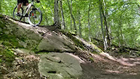
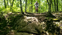
While Vietnam is legendary for its many challenging natural and man-made technical features - you'll see a lot of "big hit" bikes out on the trails - there are ways around most of the technical features and there are many more mellow as well as fast and flowy cross country trails all over Vietnam.
To see which trails are the most popular, on the map above, hit the “Trail Style” tab to open the drop down list, then hit “Popularity". The trails colored red are ridden most by Trailforks users, while the trails colored green is at the other end of the spectrum.
Most of Vietnam is served off a few spine trails. Get to know them and you will find everything. You should know The Main Trail which gives you access to all of the more technical stuff up on Rocky Ridge and the Vietnam Land and, below, to the more fun and flowy stuff around Swamp Bypass and Swamp Side, as well as the Fairbanks Trail which leads to the Kitchen, Three Ledges and Toe Jam. The Main Trail also gives you access to the awesome Three Sisters Trail, one of the best flow trails at Vietnam, and Middle Sister, one of the most fun low-tech trails in the Network.
In the Central part of the Network, everything hangs off the Holliston Highway and the Milford Byway. Both of these are easily accessed from the Adams Street Lot via Adams Lot Trail or New Trail. To get to College Rock you can go up Beaver Brook Way or Top Down, both of which takes you to Farm Way, from where you link to College Rock Run or First Base.
As a general rule, the further South you go, the more technical the trails. Most of the big technical features are on the trails that start off NEMBA Way - Mind the Gap, Down And Up, Rubber Stamp, Dirty Little Secret etc. If you don't know how to get there, we have created a special Route that you can download to get you to the NEMBA land and back, from the Adams Street Lot.
While you are up there, don't miss The Gig and Giggidy - both are fun, fast and flowy downhill trails with some awesome tech features.
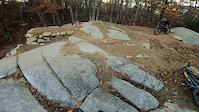
The area around Kitchen is a favorite playground amongst regulars for its many rock features. Also popular are the many big rock features such as Whaleback Rock, Optional Rocks, Condo Rock and Dolphin Rock.
The most popular and central Trailhead is at the Adams Street parking area from where you can go South towards the more technical areas (via Cross Cut and Middle Sister) or North towards the more cross country trails (via New Trail and Beaver Brook Way).
Alternatively you can stay in the area around Adams Street Lot and ride the awesome trails such as Adams Lot Trail, Town Forest Trail, Sneaky Quickie, Optional Rocks, Sudden Impact, Humpback Rock, Deer Way, Right Turn Clyde, Do You Feel Lucky, New Trail, Bumblebee and Burial Bypass.
If you are interested only in the big hit area on the NEMBA parcel, the closest parking is at the end of the Dunster Road cul-de-sac. Please do not park at the Wendy's.
Have fun
The ~1,000 acres of land that make up the Vietnam Trail Network is owned by:
- Town of Holliston, managed by the Holliston Town Forest Committee and the Holliston Conservation Commission
- Town of Milford, managed by the Milford Conservation Commission
- Town of Hopkinton, managed by the Hopkinton Conservation Commission
- New England Mountain Bike Association (47 acres), managed by the NEMBA Vietnam Land Management Committee
- Various private land owners
The NEMBA Vietnam Land Management Committee works with all the land owners/managers to ensure proper land and trail management of the entire Vietnam Trail Network.
While Vietnam is legendary for its many challenging natural and man-made technical features - you'll see a lot of "big hit" bikes out on the trails - there are ways around most of the technical features and there are many more mellow as well as fast and flowy cross country trails all over Vietnam.
To see which trails are the most popular, on the map above, hit the “Trail Style” tab to open the drop down list, then hit “Popularity". The trails colored red are ridden most by Trailforks users, while the trails colored green is at the other end of the spectrum.
Most of Vietnam is served off a few spine trails. Get to know them and you will find everything. You should know The Main Trail which gives you access to all of the more technical stuff up on Rocky Ridge and the Vietnam Land and, below, to the more fun and flowy stuff around Swamp Bypass and Swamp Side, as well as the Fairbanks Trail which leads to the Kitchen, Three Ledges and Toe Jam. The Main Trail also gives you access to the awesome Three Sisters Trail, one of the best flow trails at Vietnam, and Middle Sister, one of the most fun low-tech trails in the Network.
In the Central part of the Network, everything hangs off the Holliston Highway and the Milford Byway. Both of these are easily accessed from the Adams Street Lot via Adams Lot Trail or New Trail. To get to College Rock you can go up Beaver Brook Way or Top Down, both of which takes you to Farm Way, from where you link to College Rock Run or First Base.
As a general rule, the further South you go, the more technical the trails. Most of the big technical features are on the trails that start off NEMBA Way - Mind the Gap, Down And Up, Rubber Stamp, Dirty Little Secret etc. If you don't know how to get there, we have created a special Route that you can download to get you to the NEMBA land and back, from the Adams Street Lot.
While you are up there, don't miss The Gig and Giggidy - both are fun, fast and flowy downhill trails with some awesome tech features.
The area around Kitchen is a favorite playground amongst regulars for its many rock features. Also popular are the many big rock features such as Whaleback Rock, Optional Rocks, Condo Rock and Dolphin Rock.
The most popular and central Trailhead is at the Adams Street parking area from where you can go South towards the more technical areas (via Cross Cut and Middle Sister) or North towards the more cross country trails (via New Trail and Beaver Brook Way).
Alternatively you can stay in the area around Adams Street Lot and ride the awesome trails such as Adams Lot Trail, Town Forest Trail, Sneaky Quickie, Optional Rocks, Sudden Impact, Humpback Rock, Deer Way, Right Turn Clyde, Do You Feel Lucky, New Trail, Bumblebee and Burial Bypass.
If you are interested only in the big hit area on the NEMBA parcel, the closest parking is at the end of the Dunster Road cul-de-sac. Please do not park at the Wendy's.
Have fun
source: NEMBA Vietnam page
Primary Trail Type: Cross-Country
eBikes Allowed:
No
AKA: Nam
Land Status: City Managed
 google parking directions
 Access Info:
PARKING AT VIETNAM
Vietnam has four parking areas offering direct access to the trail system.
1) Adams Street Parking Lot
388 Adams Street, Milford: This is the most popular Vietnam trailhead. Access to the trails is directly from the lot and offers easy access to all parts of the system. Most group rides depart from here.
2) Dunster Road Parking Area
130 Dunster Road, Milford: (off Adams Street) is a cul de sac and offers on-street parking at the end of the road. This is the closest access to the NEMBA Vietnam parcel and the more technical Southern end of Vietnam. Access the trails directly from the end of the road.
3) Route 85 Milford/Hopkinton Rail Trail Parking lot
451 Cedar Street, Milford: To access the trails ride South on the dirt double track alongside the paved Rail Trail, from where there are several access points to the left into the system (Skip the first access point).
4) College Rock Parking Lot
26 College Street, Hopkinton: This unpaved lot is at the Northern end of the trails, on College Street, just before it crosses Beaver Brook Stream. Access Vietnam directly from the Parking Lot via the College Rock Run Trail.
Links
- NEMBA Vietnam FB page
- Holliston Town Forest Committee
- Holliston Conservation Commission
- Milford Conservation Comission
- Hopkinton Conservation Comission
Region Supporters & Maintainers
![]()
Milford BicycleSponsor
Activities Click to view
- Mountain Bike
140 trails
- E-Bike
132 trails
- Hike
132 trails
- Trail Running
132 trails
- Snowshoe
132 trails
- Backcountry Ski
16 trails
- Nordic Ski
131 trails
Region Details
- 3
- 34
- 66
- 20
- 1
- 1
Region Status
Open as of 15 hoursStats
- Avg Trail Rating
- Trails (view details)
- 125
- Trails Mountain Bike
- 140
- Trails E-Bike
- 132
- Trails Horse
- 1
- Trails Hike
- 132
- Trails Trail Running
- 132
- Trails Snowshoe
- 132
- Trails Backcountry Ski
- 16
- Trails Nordic Ski
- 131
- Total Distance
- 33 miles
- Total Descent
- 3,622 ft
- Total Vertical
- 208 ft
- Highest Trailhead
- 479 ft
- Reports
- 4,127
- Photos
- 736
- Ridden Counter
- 115,995
Popular Vietnam Trail Network Mountain Biking Trails
• 100 ★ 3.8 • 1,535 ft • 45 ft • 2,549 •
is the old way to get from the area over to the southern part of Vietnam, as well as the land. It is an old school double track with many baby head rocks and calls for good line choice. There is one steep river crossing on the trail
• 100 ★ 3.8 • 1,093 ft • 27 ft • 2,532 •
This easy green trail starts in the Adams Street parking lot and curves all the way up to the intersection with the .
• 100 ★ 3.0 • 561 ft • 10 ft • 2,157 •
A short fun trail that winds up the low ridge and back down to the , right where starts. It is an easy trail with a short off-camber section, a few tight turns as well as a few small rock obstacles that can be jumped. A fun way to ride...
• 95 ★ 3.8 • 2,297 ft • 18 ft • 2,117 •
The is a very technical trail in places on account of the many challenging rock obstacles. But done slowly is very doable for intermediate riders.
• 95 ★ 4.8 • 1,572 ft • 0 ft • 1,935 •
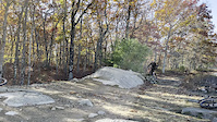
is a fast, fun flow trail, complete with a few kickers, drops and berms.
• 95 ★ 3.6 • 3,237 ft • 73 ft • 1,846 •
The is an easy, fast and flowy cross country trail. While mostly smooth, it has a few moderate climbs in both directions, a few nice rocky sections as well as a skinny hour glass bridge. At the end closest to the Adams Street lot The...
• 95 ★ 3.9 • 454 ft • 10 ft • 1,831 •
is a short trail that traverses the spine of a big whaleback with a very steep 12 foot roll-down and small drop-off lower down on the trail. Only if you are comfortable with steep rollers!
Vietnam Trail Network Mountain Bike Routes
Vietnam Hall of Fame Featured
★ 3.9 • 8 miles • 628 ft • 32 • Loop •
This route is designed as a good introduction to everything Vietnam has to offer.It passes through the...
★ 3.5 • 4 miles • 299 ft • 19 • Out & Back •
This is the quickest and most fun way to get from the Adams Street Parking Lot up to the NEMBA land where...
★ 4.2 • 2 miles • 227 ft • 4 • Point to Point •
This is the first of hopefully more monthly Nam Challenge Routes. For June, time yourself on this route...
★ 4.7 • 6 miles • 427 ft • 20 • Out & Back •
If you feel comfortable with routes 1, 2 and 3 in this series, then this route will be a modest step-up in...
★ 5.0 • 7 miles • 487 ft • 13 • Loop •
This route starts out at the Adams St parking lot and provides a moderately easy route, traversing a...
★ 5.0 • 4 miles • 300 ft • 6 • Loop •
This route starts out at the Adams St parking lot and provides a moderately easy route, traversing a...
Photos of Vietnam Trail Network Mountain Bike
Videos of Vietnam Trail Network Mountain Bike
trail: 207
0:53 |
201 |
Aug 14, 2024
trail: 207
0:08 |
549 |
May 24, 2024

trail: Root Canal
0:05 |
241 |
May 24, 2023
trail: F16
0:06 |
|
Oct 29, 2022
trail: Mind the Gap
0:09 |
517 |
Dec 6, 2021
trail: F16
0:24 |
524 |
Nov 13, 2021
trail: Giggidy
0:03 |
901 |
Aug 17, 2021
trail: Giggidy
0:10 |
721 |
Aug 17, 2021
Current Trail Warnings
| status | trail | date | condition | user | info |
|---|---|---|---|---|---|
| Dennis Playground | Jun 26, 2026 @ 6:41pm (America/New_York) 2 days | Variable | KapitolPhoto BVNEMBA Admins | Gravel Bike Small tree down across trail, can... | |
| Charles River Trail | Jun 9, 2026 @ 6:16pm (America/New_York) Jun 9, 2026 | Unknown | mappermook TRAILFORKS | It's so grown in, that it's pretty much... | |
| Quick Way Out | Jun 9, 2026 @ 2:33pm (America/New_York) Jun 9, 2026 | Ideal | mappermook TRAILFORKS | Tree down across trail in front of the... |
Recent Trail Reports
| status | trail | date | condition | info | user |
|---|---|---|---|---|---|
| College Rock Run | Jun 28, 2026 @ 3:08pm (America/New_York) 15 hours | Ideal | mike-carvalho BVNEMBA Admins | ||
| Battle Scar | Jun 21, 2026 @ 1:35pm (America/New_York) Jun 21, 2026 | Ideal | RabbiOfRhythms BVNEMBA CSP | ||
| Bumblebee | Jun 27, 2026 @ 9:04am (America/New_York) 2 days | Ideal | BikeRitz | ||
| New Trail | Jun 21, 2026 @ 1:35pm (America/New_York) Jun 21, 2026 | Ideal | RabbiOfRhythms BVNEMBA CSP | ||
| Why Not Rock | Jun 21, 2026 @ 1:35pm (America/New_York) Jun 21, 2026 | Ideal | RabbiOfRhythms BVNEMBA CSP | ||
| Hob Knob | Jun 21, 2026 @ 1:35pm (America/New_York) Jun 21, 2026 | Ideal | RabbiOfRhythms BVNEMBA CSP | ||
| NEMBA Trail | Jun 21, 2026 @ 1:35pm (America/New_York) Jun 21, 2026 | Ideal | RabbiOfRhythms BVNEMBA CSP | ||
| B Bypass | Jun 21, 2026 @ 1:35pm (America/New_York) Jun 21, 2026 | Ideal | RabbiOfRhythms BVNEMBA CSP | ||
| Giggidy | Jun 21, 2026 @ 1:35pm (America/New_York) Jun 21, 2026 | Ideal | RabbiOfRhythms BVNEMBA CSP | ||
| Gintro | Jun 21, 2026 @ 1:35pm (America/New_York) Jun 21, 2026 | Ideal | RabbiOfRhythms BVNEMBA CSP |
Activity Feed
| username | action | type | title | date |
|---|---|---|---|---|
| mike-carvalho | add | report | activity #98013425 | Jun 28, 2026 @ 12:08pm 15 hours |
| BikeRitz | add | report | activity #97977788 | Jun 28, 2026 @ 4:50am 22 hours |
| ShantanuSonparotekZf | wishlist | route | activity #97907088 | Jun 27, 2026 @ 8:39am 2 days |
| 1Pipepipe | wishlist | route | activity #97905406 and 1 more | Jun 27, 2026 @ 8:17am 2 days |
| KapitolPhoto | add | report | activity #97861401 | Jun 26, 2026 @ 3:41pm 2 days |
Recent Comments
| username | type | title | comment | date |
|---|---|---|---|---|
| report | Couldn't even get to the water part. HARDCORE... | Jun 9, 2026 @ 6:50pm Jun 9, 2026 | ||
| report | How’s the water situation? It’s been on my... | Jun 9, 2026 @ 3:25pm Jun 9, 2026 | ||
| report | big tree down on the landing | Jun 7, 2026 @ 4:42am Jun 7, 2026 | ||
| report | What’s the issue? Tree down or something else? | Jun 6, 2026 @ 8:05am Jun 6, 2026 | ||
| trail | """Flowy""" is the most overused word in New... | Feb 21, 2026 @ 9:19am Feb 21, 2026 |
Nearby Areas
| name | distance | ||||
|---|---|---|---|---|---|
| Colella's Park | 2.1 km | ||||
| Pinecrest Miller Hill | 9 | 3 | 1 | 3 | 2.4 km |
| Braim Farm | 2.5 km | ||||
| Wenakeening Woods | 28 | 11 | 2.9 km | ||
| Mighton Woods | 2 | 3 km |
Activity Type Stats
| activitytype | trails | distance | descent | descent distance | total vertical | rating | global rank | state rank | photos | reports | routes | ridelogs |
|---|---|---|---|---|---|---|---|---|---|---|---|---|
| Mountain Bike | 140 | 33 miles | 3,622 ft | 14 miles | 207 ft | #65 | #27 | 724 | 4,133 | 31 | 31,220 | |
| E-Bike | 132 | #2,302 | #772 | 3,235 | 5 | 606 | ||||||
| Horse | 1 | 1,191 ft | 7 ft | 983 | 9 | |||||||
| Hike | 132 | 32 miles | 3,596 ft | 14 miles | 207 ft | #3,272 | #1,135 | 8 | 4,114 | 559 | ||
| Trail Running | 132 | 32 miles | 3,596 ft | 14 miles | 207 ft | #2,578 | #633 | 5 | 4,114 | 408 | ||
| Snowshoe | 132 | 32 miles | 3,514 ft | 14 miles | 207 ft | #57 | #24 | 2,060 | 62 | |||
| Backcountry Ski | 16 | 4,724 ft | 59 ft | 1,604 ft | 30 ft | #176 | #33 | 932 | 7 | |||
| Nordic Ski | 131 | 27 miles | 2,963 ft | 12 miles | 207 ft | #121 | #51 | 2,018 | 16 |
Frequently Asked Questions About Vietnam Trail Network
▼
What are the highest rated mountain biking trails in Vietnam Trail Network?
The highest rated mountain biking trails in Vietnam Trail Network are:
- The Gigg (4.6/5)
- Battle Scar (4.5/5)
- Leftovers (4.5/5)
- Do You Feel Lucky (4.5/5)
- Dirty Little Secret (4.4/5)
▼
What is the best time of the year to ride in Vietnam Trail Network?
Based on ride log data, the most popular months to ride in Vietnam Trail Network are:
- May (986 activities)
- June (913 activities)
- August (894 activities)
▼
Where can I park to ride in Vietnam Trail Network?
There are 4 parking locations listed in Vietnam Trail Network. The most popular parking spots are: View all parking and trailhead locations on the map to plan your visit.
▼
What is the longest trail in Vietnam Trail Network?
The longest trail in Vietnam Trail Network is Holliston Highway at 1.3 miles. View all trails sorted by distance.
Activities
Trails
- Hard trails in Vietnam Trail Network
- Easy trails in Vietnam Trail Network
- Favorite trails in Vietnam Trail Network
- Most ridden trails in Vietnam Trail Network
- Singletrack in Vietnam Trail Network
- Viewpoint trails in Vietnam Trail Network
- Trails with technical features in Vietnam Trail Network
- Race routes in Vietnam Trail Network
- By WillieJacobsz
 Trailforks SBP SWW & contributors
 - Admins: BVNEMBA VIETNM, BVNEMBA Region, BVNEMBA Admins
- #4116 - 101,119 views
- vietnam trail network activity log | embed map of Vietnam Trail Network mountain bike trails | vietnam trail network mountain biking points of interest
Downloading of trail gps tracks in kml & gpx formats is enabled for Vietnam Trail Network.
You must login to download files.