close
-
Layers w
- Weather Layers
- Pro
- Pro
- Pro
- Pro
- Pro
- Pro
- More Layers
- Pro
- Pro
- Pro
- Pro
-
Upgrade to

3D
Trail Conditions
- Unknown
- Snow Groomed
- Snow Packed
- Snow Covered
- Snow Cover Partial
- Freeze/thaw Cycle
- Icy
- Prevalent Mud
- Wet
- Variable
- Ideal
- Dry
- Very Dry
Trail Flow (Ridden Direction)
Trailforks scans users ridelogs to determine the most popular direction each trail is ridden. A good flowing trail network will have most trails flowing in a single direction according to their intension.
The colour categories are based on what percentage of riders are riding a trail in its intended direction.
The colour categories are based on what percentage of riders are riding a trail in its intended direction.
- > 96%
- > 90%
- > 80%
- > 70%
- > 50%
- < 50%
- bi-directional trail
- no data
Trail Last Ridden
Trailforks scans ridelogs to determine the last time a trail was ridden.
- < 2 days
- < 1 week
- < 2 weeks
- < 1 month
- < 6 months
- > 6 months
Trail Ridden Direction
The intended direction a trail should be ridden.
- Downhill Only
- Downhill Primary
- Both Directions
- Uphill Primary
- Uphill Only
- One Direction
Contribute Details
Colors indicate trail is missing specified detail.
- Description
- Photos
- Description & Photos
- Videos
Trail Popularity ?
Trailforks scans ridelogs to determine which trails are ridden the most in the last 9 months.
Trails are compared with nearby trails in the same city region with a possible 25 colour shades.
Think of this as a heatmap, more rides = more kinetic energy = warmer colors.
- most popular
- popular
- less popular
- not popular
ATV/ORV/OHV Filter
Max Vehicle Width
inches
US Cell Coverage
Legend

Radar Time
Activity Recordings
Trailforks uses anonymized public activity data.
?
Activity Recordings
Trailforks uses anonymized public activity data.
?
Personal Heatmap
▶
Activity Types
all
/
none
▶
Options
2
Date range
month
–
Winter Trails
Warning
A routing network for winter maps does not exist. Selecting trails using the winter trails layer has been disabled.
Missing Trails
Most Popular
Least Popular
Trails are colored based on popularity. The more popular a trail is, the more red. Less popular trails trend towards green.
Jump Magnitude Heatmap
Heatmap of where riders jump on trails. Zoom in to see individual jumps, click circles to view jump details.
BC Backroad Status
![map legend]()
Service Road Atlas is a free to use, community-driven service for viewing and creating reports on the numerous back-country service roads around B.C. and Alberta.

Slope Aspect
Direction the slope faces
Trails Deemphasized
Trails are shown in grey.
Only show trails with no bike usage.
Suggested Layers
Based on selected activity type
Save the current map location and zoom level as your default home location whenever this page is loaded.
SaveДинамично развивающаяся зона катания недалеко от аэропорта Сочи
Primary Trail Type: All-Mountain & Downhill
eBikes Allowed:
Yes
Shuttleable: YES
Land Status: National Park
Disclaimer:
Пожалуйста спускайтесь по лестнице около пещеры с велосипедом в руках!
This region uses the Uk/Euro style trail grading system.
Activities Click to view
- Mountain Bike
6 trails
- E-Bike
6 trails
- Hike
6 trails
- Trail Running
6 trails
Region Details
- 1
- 1
- 3
- 1
Region Status
Caution as of Jul 27, 2024Stats
- Avg Trail Rating
- Trails (view details)
- 6
- Trails Mountain Bike
- 6
- Trails E-Bike
- 6
- Trails Hike
- 6
- Trails Trail Running
- 6
- Total Distance
- 4 miles
- Total Descent Distance
- 3 miles
- Total Descent
- 2,624 ft
- Total Vertical
- 1,712 ft
- Highest Trailhead
- 1,986 ft
- Reports
- 94
- Photos
- 3
- Ridden Counter
- 107
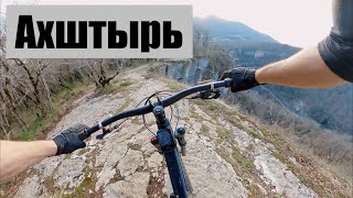
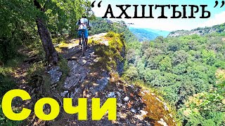
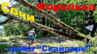
Popular Форелька Mountain Biking Trails
• 5 ★ 5.0 • 3,652 ft • 0 ft • 15 •
Первая часть трейла - видовая. После смотровой площадки начинается хороший даунхилл по камням всевозможных форм и размеров
• 5 ★ 0.0 • 2,887 ft • 0 ft • 2 •
Less popular red difficulty singletrack. This mountain bike primary trail can be used downhill only. It features rock garden. Trail visibility is always easy to follow.
Recent Trail Reports
| status | trail | date | condition | info | user |
|---|---|---|---|---|---|
| Ахштырь | Nov 13, 2021 @ 10:37pm Nov 13, 2021 | Very Dry | MishaMan | ||
| Скайпарк | Nov 13, 2021 @ 10:37pm Nov 13, 2021 | Very Dry | MishaMan | ||
| Shugar Head Access Road | Sep 20, 2020 @ 5:30am Sep 20, 2020 | Ideal | MishaMan | ||
| Лисья нора | Aug 23, 2020 @ 1:11am Aug 23, 2020 | Ideal | Arseni |
Activity Feed
| username | action | type | title | date |
|---|---|---|---|---|
| AGulwS | ridden | trail | activity #52410766 | May 11, 2024 @ 2:57am May 11, 2024 |
| Egora | vote | trail | activity #40926917 and 1 more | Jun 14, 2023 @ 12:30pm Jun 14, 2023 |
| Egora | ridden | trail | activity #40926916 and 1 more | Jun 14, 2023 @ 12:30pm Jun 14, 2023 |
| gleban4eg | comment | trail | activity #29406221 | May 16, 2022 @ 11:20pm May 16, 2022 |
| gleban4eg | vote | trail | activity #29406213 | May 16, 2022 @ 11:19pm May 16, 2022 |
Recent Comments
| username | type | title | comment | date |
|---|---|---|---|---|
| trail | Трейл в отличном... | May 16, 2022 @ 11:20pm May 16, 2022 | ||
| trail | Shugar?? :) | Sep 20, 2020 @ 9:38pm Sep 20, 2020 | ||
| trail | Организация забросом из... | Aug 29, 2020 @ 5:41am Aug 29, 2020 | ||
| trail | По поводу организации... | Sep 10, 2019 @ 7:10am Sep 10, 2019 |
Nearby Areas
| name | distance | ||||
|---|---|---|---|---|---|
| Kudepsta handmade trail park | 3 | 5.3 km | |||
| Mount Akhun | 2 | 4 | 8.1 km | ||
| Piket-Kutarka | 1 | 1 | 12.9 km | ||
| Курорт "Красная поляна" | 1 | 16.1 km | |||
| Khmeli Lakes | 16.2 km |
Activity Type Stats
| activitytype | trails | distance | descent | descent distance | total vertical | rating | global rank | state rank | photos | reports | routes | ridelogs |
|---|---|---|---|---|---|---|---|---|---|---|---|---|
| Mountain Bike | 6 | 4 miles | 2,625 ft | 3 miles | 1,713 ft | #6,734 | #38 | 3 | 94 | 137 | ||
| E-Bike | 6 | 4 miles | 2,625 ft | 3 miles | 1,713 ft | #4,048 | #46 | 91 | 29 | |||
| Hike | 6 | 4 miles | 2,625 ft | 3 miles | 1,713 ft | #6,297 | #47 | 81 | 9 | |||
| Trail Running | 6 | 4 miles | 2,625 ft | 3 miles | 1,713 ft | #5,423 | #45 | 79 | 1 |
Frequently Asked Questions About Форелька
▼
What are the highest rated mountain biking trails in Форелька?
The highest rated mountain biking trails in Форелька are:
- Ахштырь (4.3/5)
- Скайпарк (4.2/5)
- Sugar Head (0/5)
▼
What is the best time of the year to ride in Форелька?
Based on ride log data, the most popular months to ride in Форелька are:
- September (2 activities)
- October (1 activities)
▼
Where can I park to ride in Форелька?
Check the Форелька trail map for trailhead and parking information. Community members regularly update access and parking details for trails in the area.
▼
What is the longest trail in Форелька?
The longest trail in Форелька is Ахштырь at 3,652 ft. View all trails sorted by distance.
- By Avrora
 & contributors
 - Admins: ZoozR, Avrora, MishaMan
- #31524 - 1,814 views
- Форелька activity log | embed map of Форелька mountain bike trails | Форелька mountain biking points of interest
Downloading of trail gps tracks in kml & gpx formats is enabled for Форелька.
You must login to download files.