close
-
Layers w
- Weather Layers
- Pro
- Pro
- Pro
- Pro
- Pro
- Pro
- More Layers
- Pro
- Pro
- Pro
- Pro
-
Upgrade to

3D
Trail Conditions
- Unknown
- Snow Groomed
- Snow Packed
- Snow Covered
- Snow Cover Partial
- Freeze/thaw Cycle
- Icy
- Prevalent Mud
- Wet
- Variable
- Ideal
- Dry
- Very Dry
Trail Flow (Ridden Direction)
Trailforks scans users ridelogs to determine the most popular direction each trail is ridden. A good flowing trail network will have most trails flowing in a single direction according to their intension.
The colour categories are based on what percentage of riders are riding a trail in its intended direction.
The colour categories are based on what percentage of riders are riding a trail in its intended direction.
- > 96%
- > 90%
- > 80%
- > 70%
- > 50%
- < 50%
- bi-directional trail
- no data
Trail Last Ridden
Trailforks scans ridelogs to determine the last time a trail was ridden.
- < 2 days
- < 1 week
- < 2 weeks
- < 1 month
- < 6 months
- > 6 months
Trail Ridden Direction
The intended direction a trail should be ridden.
- Downhill Only
- Downhill Primary
- Both Directions
- Uphill Primary
- Uphill Only
- One Direction
Contribute Details
Colors indicate trail is missing specified detail.
- Description
- Photos
- Description & Photos
- Videos
Trail Popularity ?
Trailforks scans ridelogs to determine which trails are ridden the most in the last 9 months.
Trails are compared with nearby trails in the same city region with a possible 25 colour shades.
Think of this as a heatmap, more rides = more kinetic energy = warmer colors.
- most popular
- popular
- less popular
- not popular
ATV/ORV/OHV Filter
Max Vehicle Width
inches
US Cell Coverage
Legend

Radar Time
Activity Recordings
Trailforks uses anonymized public activity data.
?
Activity Recordings
Trailforks uses anonymized public activity data.
?
Personal Heatmap
▶
Activity Types
all
/
none
▶
Options
2
Date range
month
–
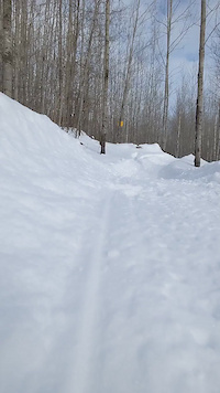
Winter Trails
Warning
A routing network for winter maps does not exist. Selecting trails using the winter trails layer has been disabled.
Missing Trails
Most Popular
Least Popular
Trails are colored based on popularity. The more popular a trail is, the more red. Less popular trails trend towards green.
Jump Magnitude Heatmap
Heatmap of where riders jump on trails. Zoom in to see individual jumps, click circles to view jump details.
BC Backroad Status
![map legend]()
Service Road Atlas is a free to use, community-driven service for viewing and creating reports on the numerous back-country service roads around B.C. and Alberta.

Slope Aspect
Direction the slope faces
Trails Deemphasized
Trails are shown in grey.
Only show trails with no bike usage.
Suggested Layers
Based on selected activity type
Save the current map location and zoom level as your default home location whenever this page is loaded.
Save
No description for Vilas County has been added yet!
Login or register to submit one.
Activities Click to view
- Mountain Bike
89 trails
- E-Bike
58 trails
- Horse
0 trails
- Hike
50 trails
- Trail Running
51 trails
- Dirtbike/Moto
1 trails
- Observed Trials
1 trails
- ATV/ORV/OHV
0 trails
- Snowmobile
0 trails
- Snowshoe
34 trails
- Downhill Ski
0 trails
- Backcountry Ski
0 trails
- Nordic Ski
54 trails
Stats
- Avg Trail Rating
- Trails (view details)
- 114
- Trails Mountain Bike
- 89
- Trails E-Bike
- 58
- Trails Gravel Bike
- 4
- Trails Adaptive Bike
- 13
- Trails Winter Fat Bike
- 32
- Trails Hike
- 50
- Trails Trail Running
- 51
- Trails Dirtbike/Moto
- 1
- Trails Observed Trials
- 1
- Trails Snowshoe
- 34
- Trails Nordic Ski
- 54
- Total Distance
- 140 miles
- Total Descent
- 8,126 ft
- Total Vertical
- 230 ft
- Highest Trailhead
- 1,838 ft
- Reports
- 620
- Photos
- 271
- Ridden Counter
- 9,861
Sub Regions
- Arbor Vitae (6)
- Eagle River (16)
- Land O' Lakes (5)
- Manitowish Waters (29)
- WinMan Trails (29)
- Plum Lake (5)
- Saint Germain (9)
- Shannon Lake (9)
- Sayner (15)
- St. Germain (4)
- Winchester (16)
Popular Vilas County Mountain Biking Trails
• 85 ★ 4.6 • 2 miles • 141 ft • 608 •
A cross country trail for all riders with moderate drops and jumps, big berms and a few fast sections.
• 95 ★ 5.0 • 2 miles • 97 ft • 544 •
A fast and flowy trail for all riders. This is a fun trail that maintains great flow by trending slightly downhill.
• 100 ★ 4.7 • 2,100 ft • 75 ft • 529 •
is a climbing trail with a couple of jumps thrown in to keep things fun. It takes riders to the central hub of the trail system allowing them to ride , , or the second portion of
• 80 ★ 4.4 • 3,058 ft • 5 ft • 484 •
is a mostly downhill trail that goes from at the highpoint of WinMan, downhill with some jumps, drops and bridges. Note, this trail is no longer a climbing trail as it used to be. Starting in 2022 it is a descend only trail.
• 90 ★ 5.0 • 2,044 ft • 2 ft • 471 •
A fun rocky trail that is mostly downhill. Has a handfull of fun rock armored doubles and a drop off of a . Lots of harder side options are available as well.
• 95 ★ 4.0 • 2 miles • 131 ft • 452 •
A fast and flowy trail for all riders. is a single trail that loops through the heart of the trail system with connections to numerous more advanced trails. There are a handful of jumps and drops with some rock gardens as well.
• 90 ★ 5.0 • 2,959 ft • 3 ft • 442 •
is a fast trail with jumps and drops for expert riders. The features are very well built and the trail is great for progressing your skills in the air and having loads of fun! There are both rock drops, table top jumps, and doubles.
Vilas County Mountain Bike Routes
Advanced Jumps Route - WinMan Featured
8 miles • 421 ft • 7 • Loop •
A favorite path through Winman to ride a many of the biggest jumps as possible. It pulls together some of...
A Bit More Technical - WinMan Featured
5 miles • 314 ft • 6 • Loop •
A tour of some of the best rocky tech, jumps, bridges and drops that WinMan has to offer.
Beginner Route - WinMan Featured
3 miles • 120 ft • 0 • Loop •
Perfect route for new mountain bikers or new riders to WinMan to better understand our trail system. Route...
Flowy Fun - WinMan Featured
6 miles • 448 ft • 0 • Loop •
Featuring some of the most fun and flowy trails at WinMan. Riders will get to experience a lot of what has...
53 miles • 2,094 ft • 2 •
GPS route of the InSayner for volunteers to follow in getting ready for the race.
10 miles • 635 ft • 6 • Loop •
A fun tour of WinMan that mixes flow, a bit of tech and all around good times on the trial.
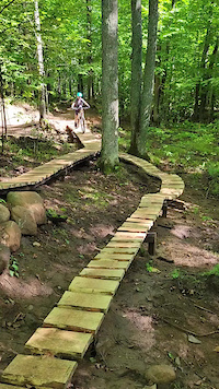
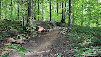
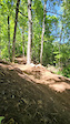
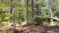
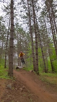
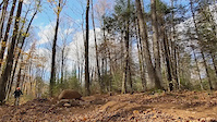
Photos of Vilas County Mountain Bike
Videos of Vilas County Mountain Bike
trail: Bridge Trail
0:08 |
26 |
Sep 15, 2023
trail: Red Trail
0:07 |
39 |
Sep 8, 2022
trail: Front Hub Return
0:07 |
19 |
Sep 6, 2022
trail: Bridge Trail
0:10 |
49 |
Jul 5, 2022
trail: Send It
0:12 |
48 |
May 31, 2022
trail: Send It
0:07 |
28 |
Jan 6, 2022
trail: Gene Machine
0:04 |
66 |
Oct 16, 2021

trail: Gene Machine
0:07 |
33 |
Oct 16, 2021
Recent Trail Reports
Activity Feed
| username | action | type | title | date |
|---|---|---|---|---|
| bcalvopina | wishlist | region | activity #96960439 | Jun 14, 2026 @ 6:07am Jun 14, 2026 |
| jacobabVOd8 | wishlist | region | activity #96252243 | Jun 4, 2026 @ 2:28pm Jun 4, 2026 |
| Auntshawn | wishlist | region | activity #96026212 | Jun 1, 2026 @ 10:20am Jun 1, 2026 |
| bdcassel | wishlist | region | activity #95776023 | May 29, 2026 @ 7:33am May 29, 2026 |
| alfotsch | add | poi | activity #95630863 and 1 more | May 27, 2026 @ 6:48am May 27, 2026 |
Recent Comments
| username | type | title | comment | date |
|---|---|---|---|---|
| trail | Great flow and a perfect mix of climb and... | Jun 11, 2025 @ 10:28am Jun 11, 2025 | ||
| trail | This trail actually goes the opposite way from... | May 30, 2025 @ 4:35pm May 30, 2025 | ||
| trail | This trail is well thought out. It will serve... | Oct 6, 2024 @ 12:30pm Oct 6, 2024 | ||
| trail | Very fun and flowy trail for all skill levels. | Sep 26, 2024 @ 3:30pm Sep 26, 2024 | ||
| trail | Mostly double track, but the single track... | Sep 22, 2024 @ 5:37pm Sep 22, 2024 |
Local Badges
-

Climbing 10k Badge0 awarded -

Epic Ride Descent 2k0 awarded -
Epic Ride Descent 2k0 awarded -

Mountain Biking 100k Badge0 awarded -
Mountain Biking 100k Badge0 awarded -

Epic Mountain Bike Climb 2k0 awarded
Bike & Skill Parks
| name | type | city | rating |
|---|---|---|---|
| WinMan Skills Park | skill park | Manitowish Waters |
Local Trail Association
Activity Type Stats
| activitytype | trails | distance | descent | descent distance | total vertical | rating | global rank | state rank | photos | reports | routes | ridelogs |
|---|---|---|---|---|---|---|---|---|---|---|---|---|
| Mountain Bike | 89 | 125 miles | 7,411 ft | 44 miles | 230 ft | 270 | 619 | 8 | 6,532 | |||
| E-Bike | 58 | 69 miles | 4,157 ft | 24 miles | 217 ft | 592 | 6 | 187 | ||||
| Gravel Bike | 4 | 2 miles | 92 ft | 2,835 ft | 190 ft | 16 | 18 | |||||
| Adaptive Bike | 13 | 25 miles | 794 ft | 7 miles | 220 ft | 142 | 17 | |||||
| Winter Fat Bike | 32 | 55 miles | 2,766 ft | 18 miles | 203 ft | 280 | 34 | |||||
| Hike | 50 | 99 miles | 5,351 ft | 36 miles | 226 ft | 607 | 320 | |||||
| Trail Running | 51 | 100 miles | 5,354 ft | 36 miles | 226 ft | 1 | 588 | 28 | ||||
| Dirtbike/Moto | 1 | 679 ft | 3 ft | 85 ft | 16 ft | 43 | 3 | |||||
| Observed Trials | 1 | 2,710 ft | 82 ft | 1,795 ft | 85 ft | |||||||
| Snowshoe | 34 | 31 miles | 2,759 ft | 12 miles | 213 ft | 235 | 65 | |||||
| Nordic Ski | 54 | 56 miles | 3,501 ft | 21 miles | 200 ft | 235 | 368 |
Frequently Asked Questions About Vilas County
▼
What are the best places to ride in Vilas County?
Vilas County has 11 areas to explore for mountain biking. The top rated areas are:
▼
What are the highest rated mountain biking trails in Vilas County?
The highest rated mountain biking trails in Vilas County are:
- Roller Creek (4.4/5)
- Send It (4.4/5)
- Lake Trail (4.4/5)
- Flowage (4.3/5)
- Scout (4.3/5)
▼
What is the best time of the year to ride in Vilas County?
Based on ride log data, the most popular months to ride in Vilas County are:
- July (91 activities)
- August (82 activities)
- September (61 activities)
▼
What is the longest trail in Vilas County?
The longest trail in Vilas County is Sayner to Boulder Junction Paved Path at 14.7 miles. View all trails sorted by distance.
Activities
Trails
Points of Interest
- By brenthillier
 NSMBA TRAILFORKS & contributors
 - Admins: MW HIKING, feardabeast, LAMBO
- #11003 - 4,843 views
- vilas county activity log | embed map of Vilas County mountain bike trails | vilas county mountain biking points of interest polygons
Downloading of trail gps tracks in kml & gpx formats is enabled for Vilas County.
You must login to download files.