close
-
Layers w
- Weather Layers
- Pro
- Pro
- Pro
- Pro
- Pro
- Pro
- More Layers
- Pro
- Pro
- Pro
- Pro
-
Upgrade to

3D
Trail Conditions
- Unknown
- Snow Groomed
- Snow Packed
- Snow Covered
- Snow Cover Partial
- Freeze/thaw Cycle
- Icy
- Prevalent Mud
- Wet
- Variable
- Ideal
- Dry
- Very Dry
Trail Flow (Ridden Direction)
Trailforks scans users ridelogs to determine the most popular direction each trail is ridden. A good flowing trail network will have most trails flowing in a single direction according to their intension.
The colour categories are based on what percentage of riders are riding a trail in its intended direction.
The colour categories are based on what percentage of riders are riding a trail in its intended direction.
- > 96%
- > 90%
- > 80%
- > 70%
- > 50%
- < 50%
- bi-directional trail
- no data
Trail Last Ridden
Trailforks scans ridelogs to determine the last time a trail was ridden.
- < 2 days
- < 1 week
- < 2 weeks
- < 1 month
- < 6 months
- > 6 months
Trail Ridden Direction
The intended direction a trail should be ridden.
- Downhill Only
- Downhill Primary
- Both Directions
- Uphill Primary
- Uphill Only
- One Direction
Contribute Details
Colors indicate trail is missing specified detail.
- Description
- Photos
- Description & Photos
- Videos
Trail Popularity ?
Trailforks scans ridelogs to determine which trails are ridden the most in the last 9 months.
Trails are compared with nearby trails in the same city region with a possible 25 colour shades.
Think of this as a heatmap, more rides = more kinetic energy = warmer colors.
- most popular
- popular
- less popular
- not popular
ATV/ORV/OHV Filter
Max Vehicle Width
inches
US Cell Coverage
Legend

Radar Time
Activity Recordings
Trailforks uses anonymized public activity data.
?
Activity Recordings
Trailforks uses anonymized public activity data.
?
Personal Heatmap
▶
Activity Types
all
/
none
▶
Options
2
Date range
month
–
Winter Trails
Warning
A routing network for winter maps does not exist. Selecting trails using the winter trails layer has been disabled.
Missing Trails
Most Popular
Least Popular
Trails are colored based on popularity. The more popular a trail is, the more red. Less popular trails trend towards green.
Jump Magnitude Heatmap
Heatmap of where riders jump on trails. Zoom in to see individual jumps, click circles to view jump details.
BC Backroad Status
![map legend]()
Service Road Atlas is a free to use, community-driven service for viewing and creating reports on the numerous back-country service roads around B.C. and Alberta.

Slope Aspect
Direction the slope faces
Trails Deemphasized
Trails are shown in grey.
Only show trails with no bike usage.
Suggested Layers
Based on selected activity type
Save the current map location and zoom level as your default home location whenever this page is loaded.
SavePopular Trail Networks
view all areas »
No description for Virginia has been added yet!
Login or register to submit one.
Region Details
- 575
- 89
- 1,082
- 1,094
- 289
- 27
Stats
- Avg Trail Rating
- Trails (view details)
- 4,594
- Trails Mountain Bike
- 3,221
- Trails E-Bike
- 1,329
- Trails Gravel Bike
- 382
- Trails Adaptive Bike
- 428
- Trails Winter Fat Bike
- 88
- Trails Horse
- 597
- Trails Hike
- 4,411
- Trails Trail Running
- 4,190
- Trails Dirtbike/Moto
- 40
- Trails ATV/ORV/OHV
- 68
- Trails Snowmobile
- 1
- Trails Snowshoe
- 27
- Trails Downhill Ski
- 68
- Trails Backcountry Ski
- 2
- Trails Nordic Ski
- 21
- Total Distance
- 5,776 miles
- Total Descent
- 871,385 ft
- Total Vertical
- 5,727 ft
- Highest Trailhead
- 5,727 ft
- Reports
- 28,904
- Photos
- 6,699
- Ridden Counter
- 394,873
Articles

Race Replay: 2026 Massanutten Bike Park - Downhill Southeast Round 3
Apr 27, 2026 from pinkbike.com
How did the riders fare on one of the roughest tracks on the circuit?

The 8 Best National Park Drives
Mar 7, 2025 from outsideonline.com
Discover America's most scenic roads with the top national park drives. Our guide features eight stunning scenic routes with must-see stops.

Want to Hike the Appalachian Trail's Most Photographed Spot? Take the Bus.
Sep 2, 2022 from backpacker.com
Volunteers hope a new bus to the McAfee Knob trailhead will cut down on congestion.
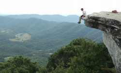
Appalachian Trail Hiker Dies After Falling from McAfee Knob
Jun 3, 2022 from outsideonline.com
The cause of Paul “Grandmaster” Classen’s fatal fall is still unclear
Sub Regions
- Alleghany Highlands of Virginia (130)
- Alleghany County (91)
- Bath County (45)
- Highland County (3)
- Blue Ridge Region VA (351)
- Botetourt County (51)
- Craig County (27)
- Floyd County (8)
- Franklin County (31)
- Henry County (9)
- Montgomery County (77)
- Roanoke County (128)
- Rockbridge County (14)
- Central Region VA (908)
- Albemarle County (Charlottesville Area) (317)
- Amelia County (1)
- Amherst County (50)
- Appomattox County (3)
- Brunswick County (2)
- Buckingham County (26)
- Caroline County (1)
- Charles City County (1)
- Charlotte County (4)
- Chesterfield County (70)
- Culpepper County (24)
- Cumberland County (9)
- Dinwiddie County (13)
- Fluvanna County (25)
- Goochland County (7)
- Greene County (32)
- Greensville County (2)
- Halifax County (14)
- Hanover County (28)
- King George County (18)
- Louisa County (1)
- Lunenburg County (1)
- Madison County (3)
- Mecklenburg County (13)
- Nelson County (1)
- Nelson County (4)
- Nottaway County (1)
- Orange County (1)
- Pittsylvania County (89)
- Powhatan County (14)
- Prince Edward County (10)
- Prince George County (0)
- Rappahannock County (3)
- Spotsylvania County (57)
- Stafford County (1)
- Surry County (6)
- Eastern Region VA (362)
- Accomac County (1)
- Chesapeake County (35)
- Gloucester County (10)
- Hampton County (2)
- Isle of Wight County (18)
- James City County (33)
- King William's County (1)
- Lancaster County (16)
- New Kent County (26)
- Norfolk County (1)
- Northampton County (18)
- Suffolk County (15)
- Virginia Beach County (67)
- Westmoreland County (1)
- York County (49)
- Greater Lynchburg Area VA (182)
- Bedford County (66)
- Campbell County (3)
- Hampton Roads (9)
- Northern Region VA (525)
- Arlington County (8)
- Fairfax County (327)
- Fauquier County (11)
- Loudoun County (29)
- Prince William County (155)
- Shenandoah Valley Region VA (502)
- Augusta County (115)
- Clarke County (1)
- Frederick County (32)
- Highland County (5)
- Page County (1)
- Rockingham County (188)
- Shenandoah County (134)
- Warren County (36)
- Southwest Region VA (287)
- Bland County (17)
- Buchanan County (2)
- Carroll County (4)
- Dickenson County (1)
- Giles County (34)
- Grayson County (3)
- Lee County (3)
- Pulaski County (56)
- Russel County (1)
- Scott County (1)
- Smyth County (21)
- Tazewell County (1)
- Washington County (90)
- Wise County (33)
- Wythe County (16)
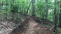
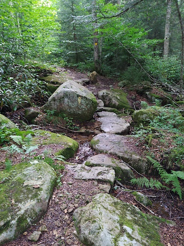
Popular Virginia Mountain Biking Trails
• 100 ★ 4.2 • 4,869 ft • 93 ft • 1,599 •
This trail will get you back to the top of Blueberry or Bell for another lap. Nice big expert log pile careful to stay straight on this feature. This trail was designed to be part of the first phase of trails in the Swift Creek area....
• 100 ★ 4.5 • 2 miles • 165 ft • 1,625 •
This trail is the first directional purpose built mountain bike only trail in the Richmond Region. The trail climbs through the hardwood forest on the northern section of Pocahontas State Park. It rides fast and has a nice set of berms....
• 100 ★ 4.7 • 1 mile • 28 ft • 1,598 •
This trail is the first directional purpose built mountain bike only trail in the Richmond Region. This downhill section has fast turns and three progressive jumps to either jump or roll. One skinny that is long and you need to pay...
• 90 ★ 4.3 • 981 ft • 0 ft • 1,492 •
This is a Intermediate rated dual slalom trail with wedge type jumps and berms. Know your limits!! Conditions change daily Pre-Ride this trail. Then Re-Ride it with first lap knowledge to learn the trail and features. Finally when you...
• 100 ★ 4.8 • 2 miles • 269 ft • 1,497 •
Fountainhead Regional Park has one of the best trail systems in the northern Virginia area. The is enjoyable, with berms, tabletops, bridges, as well as more natural features like exposed rocks and roots. It's a stand alone beginner...
• 95 ★ 4.6 • 3,196 ft • 15 ft • 1,446 •
This one way More Difficult flow trail several berms and rollers. Jumps with table tops. Sharp berm turns. Unavoidable obstacles. Conditions change daily Pre-Ride this trail. Then Re-Ride it with first lap knowledge to learn the trail...
• 85 ★ 4.0 • 1 mile • 3 ft • 1,354 •
Intermediate flow trail bump & pump with berms and rollers. Rock gardens and log crossings. This trail heads south to Swift Creek Reservoir to meet up with .
Virginia Mountain Bike Routes
Intro to Carvin's Cove Featured
★ 5.0 • 16 miles • 1,288 ft • 8 • Loop •
An intermediate-friendly introduction to Carvin's Cove. This route samples the "mids" and "lowers" at the...
Spec-Dody Classic Featured
16 miles • 2,806 ft • 4 • Loop •
This is the classic Spec-Dody loop, featuring fire road climbs and stunning backcountry singletrack...
Intro to Falling Creek Park Featured
4 miles • 326 ft • 5 •
This is a beginner-intermediate level introduction to the trails at Falling Creek Park. The route samples...
Carvin's Cove Over and Back Featured
★ 3.0 • 12 miles • 2,092 ft • 5 • Loop •
This is an over-and-back at Carvins Cove starting from the Bennett Springs parking lot. and can be swapped...
Dragon's Back Lollipop Featured
11 miles • 2,971 ft • 2 • Loop •
This route is the classic "intro to Dragon's Back" ride, complete with massive challenging singletrack...
Intro to Waid Park Featured
5 miles • 496 ft • 9 • Loop •
A starting intro ride through Waid Park that tours a lot of the intermediate trails around the park, and...
Photos of Virginia Mountain Bike
Videos of Virginia Mountain Bike

trail: Yard Sale
4:14 |
14 |
May 4, 2026

trail: Wasena Pump Track
0:14 |
6 |
Feb 15, 2026

trail: Stokesville Jump Trail
0:17 |
23 |
Nov 11, 2025

trail: Walnut Creek Park
0:13 |
92 |
Dec 20, 2024

0:06 |
22 |
Sep 17, 2024

trail: Poverty Creek
0:08 |
|
May 1, 2024
trail: Zig
0:11 |
|
Apr 6, 2024

2:09 |
20 |
Nov 20, 2023
National Scenic Trails & Official Routes
-
Allegheny Trail
- Mountain Bike
- E-Bike
- Hike
- Trail Running
Activity Feed
| username | action | type | title | date |
|---|---|---|---|---|
| bestridesdc | add | report | activity #97355347 and 10 more | Jun 19, 2026 @ 5:17pm 6 hours |
| MassanuttenMTB | add | report | activity #97332746 and 1 more | Jun 19, 2026 @ 11:27am 12 hours |
| shanemb3 | wishlist | region | activity #97327925 | Jun 19, 2026 @ 10:21am 13 hours |
| shanemb3 | wishlist | region | activity #97327783 | Jun 19, 2026 @ 10:19am 13 hours |
| shanemb3 | wishlist | region | activity #97327760 | Jun 19, 2026 @ 10:19am 13 hours |
Recent Comments
| username | type | title | comment | date |
|---|---|---|---|---|
| trail | Currently a total bushwack w like 15 trees... | Jun 18, 2026 @ 6:57am 2 days | ||
| trail | Absolute gravel heaven. This category should... | Jun 18, 2026 @ 6:55am 2 days | ||
| trail | fun blue trail, nice for a warm up lap,... | Jun 16, 2026 @ 5:24pm Jun 16, 2026 | ||
| trail | not bad, in between world cup and creamy, but... | Jun 16, 2026 @ 5:23pm Jun 16, 2026 | ||
| trail | An interesting trail, a lot of big rock chunk.... | Jun 16, 2026 @ 5:22pm Jun 16, 2026 |
Local Badges
-

10 Green Trails530 awarded -

Top 10 Trails0 awarded -

10 Blue Trails113 awarded -
10 Blue Trails157 awarded -

Epic Ride Climb 2k133 awarded -
Epic Ride Climb 2k14 awarded
Bike & Skill Parks
| name | type | city | rating |
|---|---|---|---|
| Bryce Bike Park | bike park | Basye | |
| Massanutten Bike Park | bike park | Harrisonburg | |
| Massanutten Resort | bike park | Harrisonburg | |
| Belle Isle Skills Area | skill park | Richmond | |
| Lake Fairfax Skills Park | skill park | Reston |
Upcoming Local Events
Activity Type Stats
| activitytype | trails | distance | descent | descent distance | total vertical | rating | global rank | state rank | photos | reports | routes | ridelogs |
|---|---|---|---|---|---|---|---|---|---|---|---|---|
| Mountain Bike | 3,221 | 3,925 miles | 533,022 ft | 1,727 miles | 5,381 ft | #27 | 5,718 | 28,832 | 294 | 479,410 | ||
| E-Bike | 1,329 | 1,592 miles | 149,104 ft | 645 miles | 4,432 ft | #25 | 28 | 25,646 | 40 | 16,662 | ||
| Gravel Bike | 382 | 675 miles | 54,980 ft | 286 miles | 4,390 ft | #23 | 27 | 2,143 | 14 | 2,905 | ||
| Adaptive Bike | 428 | 750 miles | 70,351 ft | 325 miles | 4,393 ft | #21 | 2,561 | 2 | 11 | |||
| Winter Fat Bike | 88 | 81 miles | 14,278 ft | 38 miles | 3,737 ft | #41 | 1,036 | 1 | 26 | |||
| Horse | 597 | 1,057 miles | 119,475 ft | 471 miles | 5,203 ft | #23 | 3 | 4,576 | 5 | 46 | ||
| Hike | 4,411 | 5,627 miles | 836,906 ft | 2,477 miles | 5,728 ft | #24 | 725 | 27,140 | 25 | 29,435 | ||
| Trail Running | 4,190 | 5,431 miles | 819,593 ft | 2,392 miles | 5,728 ft | #22 | 79 | 27,130 | 31 | 18,700 | ||
| Dirtbike/Moto | 40 | 119 miles | 16,660 ft | 52 miles | 4,134 ft | #33 | 2 | 4,154 | 1 | 83 | ||
| ATV/ORV/OHV | 68 | 130 miles | 16,004 ft | 60 miles | 4,157 ft | #33 | 17 | 4,146 | 74 | |||
| Snowmobile | 1 | 2 miles | 1,329 ft | 2 miles | 1,329 ft | #35 | 3 | 12 | ||||
| Snowshoe | 27 | 98 miles | 5,581 ft | 48 miles | 3,570 ft | #39 | 5 | 40 | ||||
| Downhill Ski | 68 | 17 miles | 12,382 ft | 16 miles | 3,038 ft | #31 | 2 | 1,497 | ||||
| Backcountry Ski | 2 | 6 miles | 154 ft | 2 miles | 1,742 ft | #31 | 2 | 212 | ||||
| Nordic Ski | 21 | 84 miles | 3,406 ft | 40 miles | 3,556 ft | #42 | 6 | 363 |
Activities
- Virginia Mountain Biking Trails
- Virginia E-Biking Trails
- Virginia Gravel Biking Trails
- Virginia Adaptive Biking Trails
- Virginia Winter Fat Biking Trails
- Virginia Horseback Trails
- Virginia Hiking Trails
- Virginia Trail Running Trails
- Virginia Dirtbiking Trails
- Virginia ATVing/Offroading Trails
- Virginia Snowshoeing Trails
- Virginia Skiing Trails
- Virginia Nordic Skiing Trails
Trails
- By canadaka
 Trailforks & contributors
 - Admins: Map Team, IMBA, chuktA, msmcfate, WillieJacobsz, PlumbBobM, ReckitRolley, colinreuter, MAH, More - Master
- #3159 - 62,828 views
- virginia activity log | embed map of Virginia mountain bike trails | virginia mountain biking points of interest polygons
Downloading of trail gps tracks in kml & gpx formats is enabled for Virginia.
You must login to download files.