close
-
Layers w
- Weather Layers
- Pro
- Pro
- Pro
- Pro
- Pro
- Pro
- More Layers
- Pro
- Pro
- Pro
- Pro
-
Upgrade to

3D
Trail Conditions
- Unknown
- Snow Groomed
- Snow Packed
- Snow Covered
- Snow Cover Partial
- Freeze/thaw Cycle
- Icy
- Prevalent Mud
- Wet
- Variable
- Ideal
- Dry
- Very Dry
Trail Flow (Ridden Direction)
Trailforks scans users ridelogs to determine the most popular direction each trail is ridden. A good flowing trail network will have most trails flowing in a single direction according to their intension.
The colour categories are based on what percentage of riders are riding a trail in its intended direction.
The colour categories are based on what percentage of riders are riding a trail in its intended direction.
- > 96%
- > 90%
- > 80%
- > 70%
- > 50%
- < 50%
- bi-directional trail
- no data
Trail Last Ridden
Trailforks scans ridelogs to determine the last time a trail was ridden.
- < 2 days
- < 1 week
- < 2 weeks
- < 1 month
- < 6 months
- > 6 months
Trail Ridden Direction
The intended direction a trail should be ridden.
- Downhill Only
- Downhill Primary
- Both Directions
- Uphill Primary
- Uphill Only
- One Direction
Contribute Details
Colors indicate trail is missing specified detail.
- Description
- Photos
- Description & Photos
- Videos
Trail Popularity ?
Trailforks scans ridelogs to determine which trails are ridden the most in the last 9 months.
Trails are compared with nearby trails in the same city region with a possible 25 colour shades.
Think of this as a heatmap, more rides = more kinetic energy = warmer colors.
- most popular
- popular
- less popular
- not popular
ATV/ORV/OHV Filter
Max Vehicle Width
inches
US Cell Coverage
Legend

Radar Time
Activity Recordings
Trailforks uses anonymized public activity data.
?
Activity Recordings
Trailforks uses anonymized public activity data.
?
Personal Heatmap
▶
Activity Types
all
/
none
▶
Options
2
Date range
month
–
Winter Trails
Warning
A routing network for winter maps does not exist. Selecting trails using the winter trails layer has been disabled.
Missing Trails
Most Popular
Least Popular
Trails are colored based on popularity. The more popular a trail is, the more red. Less popular trails trend towards green.
Jump Magnitude Heatmap
Heatmap of where riders jump on trails. Zoom in to see individual jumps, click circles to view jump details.
BC Backroad Status
![map legend]()
Service Road Atlas is a free to use, community-driven service for viewing and creating reports on the numerous back-country service roads around B.C. and Alberta.

Slope Aspect
Direction the slope faces
Trails Deemphasized
Trails are shown in grey.
Only show trails with no bike usage.
Suggested Layers
Based on selected activity type
Save the current map location and zoom level as your default home location whenever this page is loaded.
Save
No description for Wading River has been added yet!
Login or register to submit one.
Activities Click to view
- Mountain Bike
13 trails
- Adaptive Bike
0 trails
- Winter Fat Bike
0 trails
- Hike
13 trails
- Trail Running
13 trails
Region Details
- 3
- 4
- 6
Region Status
Open as of May 11, 2026Stats
- Avg Trail Rating
- Trails (view details)
- 13
- Trails Mountain Bike
- 13
- Trails Hike
- 13
- Trails Trail Running
- 13
- Total Distance
- 14 miles
- Total Descent Distance
- 4 miles
- Total Descent
- 599 ft
- Total Vertical
- 119 ft
- Highest Trailhead
- 174 ft
- Reports
- 137
- Photos
- 27
- Ridden Counter
- 762
Sub Regions
-
Calverton Pine Barrens
- 3
- 6
-
Wildwood State Park
- 3
- 1
Popular Wading River Mountain Biking Trails
• 100 ★ 3.5 • 3 miles • 32 ft • 270 •
is the third (and last) section of the Main Loop at Calverton. It is mostly flat, fast, and twisty. There are some limited sight lines because of the combination of brush and tight turns. There are some stumps that will catch your...
• 95 ★ 3.5 • 3 miles • 17 ft • 256 •
This is the first of three sections constituting the Main Loop at Calverton. It is flat and somewhat twisty. There is usually a fair amount of organic matter on the trail (leaves, pine needles, and small branches).
• 80 ★ 0.0 • 2,697 ft • 35 ft • 216 •
The section name says it all. This is a lollipop loop (with a short stick) that has six down-and-up sections.
• 75 ★ 0.0 • 1,670 ft • 18 ft • 199 •
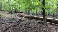
was named for having multiple log-overs. As of early 2019, these have deteriorated and are not much of a challenge. This is probably the easiest of the five optional sections at Calverton.
• 60 ★ 0.0 • 2,297 ft • 21 ft • 198 •
Scuttlehole is the toughest of the five black diamonds at Calverton. It starts with a bumpy fast downhill down into the hole, then turns uphill for the toughest climb at Calverton, levels off, goes through a couple of tight trees, then...
• 65 ★ 0.0 • 1,604 ft • 19 ft • 190 •
Hillside Driver starts with a fast righthand downhill, then hits a berm (that is slippery near the top) goes up, then down and eventually winds around to a climb near the end. Exiting the section, you proceed straight across the...
• 50 ★ 4.0 • 1 mile • 63 ft • 187 •
This is the second section of the Main Loop at Calverton and connects all five of the optional sections.
• 90 ★ 0.0 • 1,729 ft • 12 ft • 183 •
The entrance to starts with an uphill with sometimes-sketchy traction, and includes a few up and downs, and a couple of tight trees.
Wading River Mountain Bike Routes
Calverton Complete Featured
★ 5.0 • 9 miles • 210 ft • 8 • Loop •
This route includes all of Calverton Otis Pike Preserve.
Calverton Blue Only Featured
★ 5.0 • 7 miles • 115 ft • 5 • Loop •
This route includes only BLUE easier trail at Calverton Otis Pike Preserve.
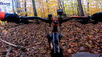
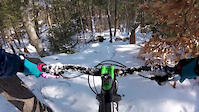
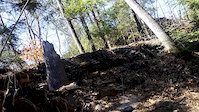
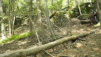
Photos of Wading River Mountain Bike
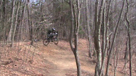
Videos of Wading River Mountain Bike
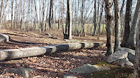
trail: Log Ride
0:08 |
108 |
Dec 6, 2021
trail: Log Ride
0:49 |
49 |
Nov 16, 2018
trail: Log Ride
0:13 |
93 |
Feb 16, 2017
trail: Log Ride
0:08 |
53 |
Oct 13, 2016
trail: Log Ride
0:19 |
74 |
Jun 9, 2016
trail: Log Ride
0:18 |
392 |
Jun 23, 2013

trail: Log Ride
3:36 |
1245 |
May 12, 2013
trail: Log Ride
6:15 |
333 |
Mar 31, 2013
Recent Trail Reports
| status | trail | date | condition | info | user |
|---|---|---|---|---|---|
| The Oak Maze | Nov 12, 2025 @ 10:06am (America/New_York) Nov 12, 2025 | Dry | Clamdaddy | ||
| Enchanted Forest | Nov 12, 2025 @ 10:06am (America/New_York) Nov 12, 2025 | Dry | Clamdaddy | ||
| The Winding Way | Jul 12, 2025 @ 12:49pm Jul 12, 2025 | Dry | DGeissert | ||
| Fox Hollow | Jun 28, 2025 @ 7:27am Jun 28, 2025 | Wet | Polecatwillie | ||
| Scuttle Hole | Apr 27, 2025 @ 6:12am Apr 27, 2025 | Unknown | Jkstang78 | ||
| Log Ride | Nov 3, 2024 @ 8:30am Nov 3, 2024 | Dry | urbanrob | ||
| Roller Coaster | Nov 3, 2024 @ 8:30am Nov 3, 2024 | Dry | urbanrob | ||
| Hillside Drive | Jan 28, 2024 @ 1:44pm Jan 28, 2024 | Ideal | MTBMarcin CLIMB | ||
| Roller Coaster Connector | Jun 30, 2023 @ 5:06am Jun 30, 2023 | Variable | MTBMarcin CLIMB |
Activity Feed
| username | action | type | title | date |
|---|---|---|---|---|
| Polecatwillie | add | photo | activity #95747116 | May 28, 2026 @ 6:04pm May 28, 2026 |
| Polecatwillie | add | photo | activity #95717740 and 2 more | May 28, 2026 @ 10:34am May 28, 2026 |
| LMCxGo4n | wishlist | route | activity #94629674 | May 13, 2026 @ 8:39am May 13, 2026 |
| MTBMarcin | update | trail | activity #93967389 | May 3, 2026 @ 11:32am May 3, 2026 |
| MTBMarcin | comment | report | activity #84041338 | Nov 12, 2025 @ 2:28pm Nov 12, 2025 |
Recent Comments
| username | type | title | comment | date |
|---|---|---|---|---|
| report | Welcome back! Thank you for reporting. | Nov 12, 2025 @ 2:28pm Nov 12, 2025 | ||
| report | Thank you for reporting! | Jul 13, 2025 @ 7:06am Jul 13, 2025 | ||
| report | Thank you for reporting! | Jul 13, 2025 @ 7:06am Jul 13, 2025 | ||
| report | Thank you for reporting! | Jul 13, 2025 @ 7:06am Jul 13, 2025 | ||
| report | Hahaha....I did not realize that this posted..... | Jun 28, 2025 @ 7:08pm Jun 28, 2025 |
Local Badges
-

Epic Mountain Bike Climb 2k0 awarded -

Climbing 10k Badge2 awarded -

Mountain Biking 100k Badge0 awarded -

Epic Ride Descent 2k0 awarded -

Descent 10k Badge2 awarded -

Descent 100k Badge0 awarded
Activity Type Stats
| activitytype | trails | distance | descent | descent distance | total vertical | rating | global rank | state rank | photos | reports | routes | ridelogs |
|---|---|---|---|---|---|---|---|---|---|---|---|---|
| Mountain Bike | 13 | 14 miles | 600 ft | 4 miles | 118 ft | #6,471 | #2,189 | 27 | 137 | 2 | 1,965 | |
| Hike | 13 | 14 miles | 600 ft | 4 miles | 118 ft | #10,314 | #3,668 | 134 | 45 | |||
| Trail Running | 13 | 14 miles | 600 ft | 4 miles | 118 ft | #9,830 | #3,353 | 134 | 14 |
Frequently Asked Questions About Wading River
▼
What are the best places to ride in Wading River?
Wading River has 2 areas to explore for mountain biking. The top rated areas are:
▼
What are the highest rated mountain biking trails in Wading River?
The highest rated mountain biking trails in Wading River are:
- Enchanted Forest (4/5)
- The Oak Maze (3.9/5)
- The Winding Way (3.9/5)
- Log Ride (0/5)
- Fox Hollow (0/5)
▼
What is the best time of the year to ride in Wading River?
Based on ride log data, the most popular months to ride in Wading River are:
- August (37 activities)
- September (29 activities)
- May (26 activities)
▼
Where can I park to ride in Wading River?
- By MTBMarcin
 CLIMB & contributors
 - Admins: CLIMB
- #18226 - 1,806 views
- wading river activity log | embed map of Wading River mountain bike trails | wading river mountain biking points of interest
Downloading of trail gps tracks in kml & gpx formats is enabled for Wading River.
You must login to download files.