close
-
Layers w
- Weather Layers
- Pro
- Pro
- Pro
- Pro
- Pro
- Pro
- More Layers
- Pro
- Pro
- Pro
- Pro
-
Upgrade to

3D
Trail Conditions
- Unknown
- Snow Groomed
- Snow Packed
- Snow Covered
- Snow Cover Partial
- Freeze/thaw Cycle
- Icy
- Prevalent Mud
- Wet
- Variable
- Ideal
- Dry
- Very Dry
Trail Flow (Ridden Direction)
Trailforks scans users ridelogs to determine the most popular direction each trail is ridden. A good flowing trail network will have most trails flowing in a single direction according to their intension.
The colour categories are based on what percentage of riders are riding a trail in its intended direction.
The colour categories are based on what percentage of riders are riding a trail in its intended direction.
- > 96%
- > 90%
- > 80%
- > 70%
- > 50%
- < 50%
- bi-directional trail
- no data
Trail Last Ridden
Trailforks scans ridelogs to determine the last time a trail was ridden.
- < 2 days
- < 1 week
- < 2 weeks
- < 1 month
- < 6 months
- > 6 months
Trail Ridden Direction
The intended direction a trail should be ridden.
- Downhill Only
- Downhill Primary
- Both Directions
- Uphill Primary
- Uphill Only
- One Direction
Contribute Details
Colors indicate trail is missing specified detail.
- Description
- Photos
- Description & Photos
- Videos
Trail Popularity ?
Trailforks scans ridelogs to determine which trails are ridden the most in the last 9 months.
Trails are compared with nearby trails in the same city region with a possible 25 colour shades.
Think of this as a heatmap, more rides = more kinetic energy = warmer colors.
- most popular
- popular
- less popular
- not popular
ATV/ORV/OHV Filter
Max Vehicle Width
inches
US Cell Coverage
Legend

Radar Time
Activity Recordings
Trailforks uses anonymized public activity data.
?
Activity Recordings
Trailforks uses anonymized public activity data.
?
Personal Heatmap
▶
Activity Types
all
/
none
▶
Options
2
Date range
month
–
Winter Trails
Warning
A routing network for winter maps does not exist. Selecting trails using the winter trails layer has been disabled.
Missing Trails
Most Popular
Least Popular
Trails are colored based on popularity. The more popular a trail is, the more red. Less popular trails trend towards green.
Jump Magnitude Heatmap
Heatmap of where riders jump on trails. Zoom in to see individual jumps, click circles to view jump details.
BC Backroad Status
![map legend]()
Service Road Atlas is a free to use, community-driven service for viewing and creating reports on the numerous back-country service roads around B.C. and Alberta.

Slope Aspect
Direction the slope faces
Trails Deemphasized
Trails are shown in grey.
Only show trails with no bike usage.
Suggested Layers
Based on selected activity type
Save the current map location and zoom level as your default home location whenever this page is loaded.
Save
No description for Walker County has been added yet!
Login or register to submit one.
Activities Click to view
- Mountain Bike
49 trails
- E-Bike
2 trails
- Horse
26 trails
- Hike
65 trails
- Trail Running
64 trails
- Dirtbike/Moto
22 trails
- ATV/ORV/OHV
22 trails
Region Details
- 3
- 1
- 16
- 19
Stats
- Avg Trail Rating
- Trails (view details)
- 54
- Trails Mountain Bike
- 49
- Trails E-Bike
- 2
- Trails Horse
- 26
- Trails Hike
- 65
- Trails Trail Running
- 64
- Trails Dirtbike/Moto
- 22
- Trails ATV/ORV/OHV
- 22
- Total Distance
- 154 miles
- Total Descent
- 10,005 ft
- Total Vertical
- 297 ft
- Highest Trailhead
- 499 ft
- Reports
- 222
- Photos
- 52
- Ridden Counter
- 3,252
Sub Regions
Popular Walker County Mountain Biking Trails
• 95 ★ 3.0 • 3,392 ft • 13 ft • 279 •
Basic climbs, some tree roots as obstacles.
• 55 ★ 3.0 • 1,765 ft • 0 ft • 219 •
Moderately popular blue difficulty singletrack. This mountain bike primary trail can be used both directions. On average it takes 2 minutes to complete this trail.
• 70 ★ 3.5 • 6 miles • 333 ft • 218 •
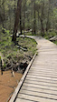
This is the main loop around Lake Raven. This fun trail has lots of roots, some boardwalks, and plenty of sand. Watch your speed in the corners when it is dry due to the sand! There is a few short punchy climbs and a few small drops off...
• 95 ★ 4.5 • 5,026 ft • 141 ft • 181 •
Use this trail to access the remainder of the NWCC trails from Huntsville State Park
• 90 ★ 0.0 • 3,283 ft • 82 ft • 179 •
Popular green difficulty singletrack. This multi-use trail can be used both directions. Trail visibility is always easy to follow. On average it takes 4 minutes to complete this trail.
• 80 ★ 4.4 • 4 miles • 365 ft • 163 •
Great, mostly smooth trail through the piney woods with lots of twists and turns!
• 50 ★ 3.0 • 1 mile • 78 ft • 137 •
Moderately popular blue difficulty singletrack. This mountain bike primary trail. On average it takes 5 minutes to complete this trail.
Photos of Walker County Mountain Bike
Videos of Walker County Mountain Bike
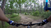
trail: Chinquapin Trail
0:19 |
55 |
Mar 27, 2025
trail: Chinquapin Trail
0:16 |
27 |
Mar 27, 2025
21:53 |
488 |
May 31, 2015
Recent Trail Reports
Activity Feed
| username | action | type | title | date |
|---|---|---|---|---|
| Abrahamn4QBMc | wishlist | trail | activity #96315840 and 1 more | Jun 5, 2026 @ 12:50pm Jun 5, 2026 |
| ChettMac | ridden | trail | activity #91491863 | Mar 28, 2026 @ 8:32pm Mar 28, 2026 |
| szlosej | add | report | activity #91302092 and 2 more | Mar 25, 2026 @ 7:08pm Mar 25, 2026 |
| szlosej | add | report | activity #91302091 and 1 more | Mar 25, 2026 @ 7:08pm Mar 25, 2026 |
| cameronripple | wishlist | region | activity #90919930 | Mar 20, 2026 @ 8:39am Mar 20, 2026 |
Recent Comments
| username | type | title | comment | date |
|---|---|---|---|---|
| trail | Currently closed from the East side. | Nov 26, 2025 @ 8:52pm Nov 26, 2025 | ||
| report | I'm joummo but but h | Sep 24, 2025 @ 12:40pm Sep 24, 2025 | ||
| trail | If dirt bikes and atvs are allowed, why are... | Jan 13, 2025 @ 8:10pm Jan 13, 2025 | ||
| report | Thanks Rick for the update! There is a lot of... | Aug 21, 2024 @ 5:24am Aug 21, 2024 | ||
| trail | Trail surface conditions are good. Foliage is... | Jun 28, 2023 @ 7:33pm Jun 28, 2023 |
Local Badges
-

Epic Mountain Bike Climb 2k0 awarded -

Mountain Biking 100k Badge0 awarded -

Climbing 10k Badge0 awarded -

Epic Ride Descent 2k0 awarded -

Descent 100k Badge0 awarded -

Descent 10k Badge2 awarded
Activity Type Stats
| activitytype | trails | distance | descent | descent distance | total vertical | rating | global rank | state rank | photos | reports | routes | ridelogs |
|---|---|---|---|---|---|---|---|---|---|---|---|---|
| Mountain Bike | 49 | 86 miles | 6,821 ft | 36 miles | 282 ft | 48 | 222 | 4,030 | ||||
| E-Bike | 2 | 176 | 130 | |||||||||
| Horse | 26 | 56 miles | 4,843 ft | 22 miles | 233 ft | 44 | ||||||
| Hike | 65 | 154 miles | 10,007 ft | 63 miles | 299 ft | 7 | 222 | 252 | ||||
| Trail Running | 64 | 154 miles | 9,977 ft | 62 miles | 299 ft | 221 | 158 | |||||
| Dirtbike/Moto | 22 | 56 miles | 4,843 ft | 22 miles | 233 ft | 44 | 29 | |||||
| ATV/ORV/OHV | 22 | 56 miles | 4,843 ft | 22 miles | 233 ft | 44 | 4 |
Frequently Asked Questions About Walker County
▼
What are the best places to ride in Walker County?
Walker County has 5 areas to explore for mountain biking. The top rated areas are:
▼
What are the highest rated mountain biking trails in Walker County?
The highest rated mountain biking trails in Walker County are:
- North Loop (4.1/5)
- Inner Loop (4.1/5)
- Start Hill (4.1/5)
- South Loop (4.1/5)
- NW- Blue Loop (4/5)
▼
What is the best time of the year to ride in Walker County?
Based on ride log data, the most popular months to ride in Walker County are:
- October (51 activities)
- July (41 activities)
- September (39 activities)
▼
What is the longest trail in Walker County?
The longest trail in Walker County is NW- Blue Loop at 16.6 miles. View all trails sorted by distance.
Activities
Trails
Points of Interest
- By markholloway
 Trailforks Map Team & contributors
 - Admins: TX Hiking, Turntex
- #13778 - 2,029 views
- walker county activity log | embed map of Walker County mountain bike trails | walker county mountain biking points of interest
Downloading of trail gps tracks in kml & gpx formats is enabled for Walker County.
You must login to download files.