close
-
Layers w
- Weather Layers
- Pro
- Pro
- Pro
- Pro
- Pro
- Pro
- More Layers
- Pro
- Pro
- Pro
- Pro
-
Upgrade to

3D
Trail Conditions
- Unknown
- Snow Groomed
- Snow Packed
- Snow Covered
- Snow Cover Partial
- Freeze/thaw Cycle
- Icy
- Prevalent Mud
- Wet
- Variable
- Ideal
- Dry
- Very Dry
Trail Flow (Ridden Direction)
Trailforks scans users ridelogs to determine the most popular direction each trail is ridden. A good flowing trail network will have most trails flowing in a single direction according to their intension.
The colour categories are based on what percentage of riders are riding a trail in its intended direction.
The colour categories are based on what percentage of riders are riding a trail in its intended direction.
- > 96%
- > 90%
- > 80%
- > 70%
- > 50%
- < 50%
- bi-directional trail
- no data
Trail Last Ridden
Trailforks scans ridelogs to determine the last time a trail was ridden.
- < 2 days
- < 1 week
- < 2 weeks
- < 1 month
- < 6 months
- > 6 months
Trail Ridden Direction
The intended direction a trail should be ridden.
- Downhill Only
- Downhill Primary
- Both Directions
- Uphill Primary
- Uphill Only
- One Direction
Contribute Details
Colors indicate trail is missing specified detail.
- Description
- Photos
- Description & Photos
- Videos
Trail Popularity ?
Trailforks scans ridelogs to determine which trails are ridden the most in the last 9 months.
Trails are compared with nearby trails in the same city region with a possible 25 colour shades.
Think of this as a heatmap, more rides = more kinetic energy = warmer colors.
- most popular
- popular
- less popular
- not popular
ATV/ORV/OHV Filter
Max Vehicle Width
inches
US Cell Coverage
Legend

Radar Time
Activity Recordings
Trailforks uses anonymized public activity data.
?
Activity Recordings
Trailforks uses anonymized public activity data.
?
Personal Heatmap
▶
Activity Types
all
/
none
▶
Options
2
Date range
month
–
Winter Trails
Warning
A routing network for winter maps does not exist. Selecting trails using the winter trails layer has been disabled.
Missing Trails
Most Popular
Least Popular
Trails are colored based on popularity. The more popular a trail is, the more red. Less popular trails trend towards green.
Jump Magnitude Heatmap
Heatmap of where riders jump on trails. Zoom in to see individual jumps, click circles to view jump details.
BC Backroad Status
![map legend]()
Service Road Atlas is a free to use, community-driven service for viewing and creating reports on the numerous back-country service roads around B.C. and Alberta.

Slope Aspect
Direction the slope faces
Trails Deemphasized
Trails are shown in grey.
Only show trails with no bike usage.
Suggested Layers
Based on selected activity type
Save the current map location and zoom level as your default home location whenever this page is loaded.
SaveWanatee Park, a 998 acre park at 1600 Banner Drive, Marion, is located on the corner of Highway 13 and Highway 100. The park offers opportunities for picnicking, camping, winter activities, nature study and more. Wanatee Park is named after Adeline Wanatee (1910-1996), an artist and advocate for Native American and women's rights, and a 1993 Iowa Women's Hall of Fame honoree. A variety of wildlife and the proximity to the metropolitan area makes Wanatee Park a popular destination for outdoor recreation. The Wanatee Park Mountain Bike Trails close year for a managed deer hunt from November 1st to January 10th.
 google parking directions
 Activities Click to view
- Mountain Bike
21 trails
- E-Bike
8 trails
- Hike
12 trails
- Trail Running
13 trails
Region Details
- 2
- 7
- 12
Region Status
Open as of Apr 30, 2025Stats
- Avg Trail Rating
- Trails (view details)
- 21
- Trails Mountain Bike
- 21
- Trails E-Bike
- 8
- Trails Horse
- 2
- Trails Hike
- 12
- Trails Trail Running
- 13
- Total Distance
- 5 miles
- Total Descent Distance
- 2 miles
- Total Descent
- 462 ft
- Total Vertical
- 108 ft
- Highest Trailhead
- 882 ft
- Reports
- 53
- Photos
- 39
- Ridden Counter
- 988
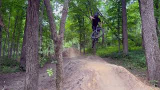
Popular Wanatee Park Mountain Biking Trails
• 95 ★ 4.4 • 1,335 ft • 31 ft • 154 •
Another professionally-built singletrack at Wanatee Park, is a blue rated (more difficult) singletrack with flow elements (berms, rollers, lifts, etc.) and two boardwalks that ride just as good, if not better, than the trail. This trail...
• 95 ★ 4.5 • 2 miles • 177 ft • 133 •
LAMBA's original installation of singletrack at Wanatee Park in 2011, with updated routing and addition of flow elements (berms, rollers, jumps, etc.) in 201. This particular trail is rated blue (more difficult) often tight and twisty,...
• 90 ★ 4.8 • 2 miles • 115 ft • 132 •
The is LAMBA and Linn County’s professional installation of natural surface singletrack at Wanatee Park. The is a green rated (less difficult) bi-directional singletrack trail packed with flow elements (berms, rollers, lifts, etc.)....
• 95 ★ 5.0 • 1,024 ft • 52 ft • 109 •
is a suggested one-way climbing trail to help be a one-way descent .. heart rate increasing push from the bottom of up to the
• 100 ★ 5.0 • 1,683 ft • 0 ft • 94 •
Popular blue difficulty singletrack. This mountain bike primary trail can be used downhill only. It features berm, drop, jump and wallride. On average it takes 6 minutes to complete this trail.
• 100 ★ 5.0 • 1,824 ft • 6 ft • 81 •
Popular green difficulty singletrack. This mountain bike primary trail. It features a-frame, bridge and log ride. On average it takes 2 minutes to complete this trail.
• 75 ★ 0.0 • 774 ft • 0 ft • 37 •
Popular blue difficulty singletrack. This mountain bike primary trail can be used downhill only.
• 90 ★ 0.0 • 276 ft • 0 ft • 21 •
Popular blue difficulty mixed. This mountain bike primary trail can be used both directions.

Recent Trail Reports
| status | trail | date | condition | info | user |
|---|---|---|---|---|---|
| Red Cedar | Apr 30, 2025 @ 5:39pm Apr 30, 2025 | Ideal | Stumpy12-9 | ||
| Billy Goat | Apr 30, 2025 @ 5:39pm Apr 30, 2025 | Ideal | Stumpy12-9 | ||
| Derecho | Apr 30, 2025 @ 5:39pm Apr 30, 2025 | Ideal | Stumpy12-9 | ||
| Irene | Sep 29, 2024 @ 11:54am Sep 29, 2024 | Very Dry | Mandylyn70 QC FORC | ||
| Troll Holler | Sep 29, 2024 @ 11:54am Sep 29, 2024 | Very Dry | Mandylyn70 QC FORC | ||
| Meadowlark | Jun 21, 2024 @ 11:07am Jun 21, 2024 | Ideal | Stumpy12-9 |
Activity Feed
| username | action | type | title | date |
|---|---|---|---|---|
| patrickveronda | wishlist | region | activity #96974046 | Jun 14, 2026 @ 8:50am Jun 14, 2026 |
| Bloomer94 | wishlist | region | activity #94710778 | May 14, 2026 @ 2:06pm May 14, 2026 |
| JennaGdofN5 | wishlist | trail | activity #93355542 | Apr 25, 2026 @ 7:49am Apr 25, 2026 |
| BenjaminxdfGCO | wishlist | trail | activity #92571674 and 1 more | Apr 13, 2026 @ 6:14pm Apr 13, 2026 |
| viw-trails | update | trail | activity #91709490 and 2 more | Apr 1, 2026 @ 8:40am Apr 1, 2026 |
Nearby Areas
| name | distance | ||||
|---|---|---|---|---|---|
| Boyson Park | 3 | 3.4 km | |||
| Sac & Fox Trail City Park | 5 | 5 | 1 | 4.7 km | |
| Mt. Trashmore | 1 | 5.3 km | |||
| Seminole Valley Park | 4 | 5 | 1 | 8.3 km | |
| Beverly Park | 12 | 12 | 5 | 1 | 8.4 km |
Bike & Skill Parks
| name | type | city | rating |
|---|---|---|---|
| Wanatee Skills Park | skill park | Cedar Rapids |
Activity Type Stats
| activitytype | trails | distance | descent | descent distance | total vertical | rating | global rank | state rank | photos | reports | routes | ridelogs |
|---|---|---|---|---|---|---|---|---|---|---|---|---|
| Mountain Bike | 21 | 5 miles | 463 ft | 2 miles | 108 ft | #4,941 | #1,780 | 39 | 53 | 1,395 | ||
| E-Bike | 8 | #9,687 | #3,280 | 29 | 28 | |||||||
| Horse | 2 | 9 | ||||||||||
| Hike | 12 | 5 miles | 387 ft | 2 miles | 108 ft | #14,145 | #6,156 | 53 | 16 | |||
| Trail Running | 13 | 5 miles | 387 ft | 2 miles | 108 ft | #14,362 | #6,125 | 53 | 12 |
Frequently Asked Questions About Wanatee Park
▼
What are the highest rated mountain biking trails in Wanatee Park?
The highest rated mountain biking trails in Wanatee Park are:
- Red Cedar (4.4/5)
- Irene (4.2/5)
- Billy Goat (4.2/5)
- Troll Holler (4.2/5)
- Derecho (4.1/5)
▼
What is the best time of the year to ride in Wanatee Park?
Based on ride log data, the most popular months to ride in Wanatee Park are:
- July (39 activities)
- August (33 activities)
- June (25 activities)
▼
Where can I park to ride in Wanatee Park?
There are 3 parking locations listed in Wanatee Park. The most popular parking spots are: View all parking and trailhead locations on the map to plan your visit.
▼
What is the longest trail in Wanatee Park?
The longest trail in Wanatee Park is Equestrian/Multi-Use Trail at 2.4 miles. View all trails sorted by distance.
Activities
Trails
Points of Interest
- By brenthillier
 NSMBA TRAILFORKS & contributors
 - Admins: LAMBA, BackyardTrails, LAMBA
- #22729 - 9,298 views
- wanatee park activity log | embed map of Wanatee Park mountain bike trails | wanatee park mountain biking points of interest polygons
Downloading of trail gps tracks in kml & gpx formats is enabled for Wanatee Park.
You must login to download files.