close
-
Layers w
- Weather Layers
- Pro
- Pro
- Pro
- Pro
- Pro
- Pro
- More Layers
- Pro
- Pro
- Pro
- Pro
-
Upgrade to

3D
Trail Conditions
- Unknown
- Snow Groomed
- Snow Packed
- Snow Covered
- Snow Cover Partial
- Freeze/thaw Cycle
- Icy
- Prevalent Mud
- Wet
- Variable
- Ideal
- Dry
- Very Dry
Trail Flow (Ridden Direction)
Trailforks scans users ridelogs to determine the most popular direction each trail is ridden. A good flowing trail network will have most trails flowing in a single direction according to their intension.
The colour categories are based on what percentage of riders are riding a trail in its intended direction.
The colour categories are based on what percentage of riders are riding a trail in its intended direction.
- > 96%
- > 90%
- > 80%
- > 70%
- > 50%
- < 50%
- bi-directional trail
- no data
Trail Last Ridden
Trailforks scans ridelogs to determine the last time a trail was ridden.
- < 2 days
- < 1 week
- < 2 weeks
- < 1 month
- < 6 months
- > 6 months
Trail Ridden Direction
The intended direction a trail should be ridden.
- Downhill Only
- Downhill Primary
- Both Directions
- Uphill Primary
- Uphill Only
- One Direction
Contribute Details
Colors indicate trail is missing specified detail.
- Description
- Photos
- Description & Photos
- Videos
Trail Popularity ?
Trailforks scans ridelogs to determine which trails are ridden the most in the last 9 months.
Trails are compared with nearby trails in the same city region with a possible 25 colour shades.
Think of this as a heatmap, more rides = more kinetic energy = warmer colors.
- most popular
- popular
- less popular
- not popular
ATV/ORV/OHV Filter
Max Vehicle Width
inches
US Cell Coverage
Legend

Radar Time
Activity Recordings
Trailforks uses anonymized public activity data.
?
Activity Recordings
Trailforks uses anonymized public activity data.
?
Personal Heatmap
▶
Activity Types
all
/
none
▶
Options
2
Date range
month
–
Winter Trails
Warning
A routing network for winter maps does not exist. Selecting trails using the winter trails layer has been disabled.
Missing Trails
Most Popular
Least Popular
Trails are colored based on popularity. The more popular a trail is, the more red. Less popular trails trend towards green.
Jump Magnitude Heatmap
Heatmap of where riders jump on trails. Zoom in to see individual jumps, click circles to view jump details.
BC Backroad Status
![map legend]()
Service Road Atlas is a free to use, community-driven service for viewing and creating reports on the numerous back-country service roads around B.C. and Alberta.

Slope Aspect
Direction the slope faces
Trails Deemphasized
Trails are shown in grey.
Only show trails with no bike usage.
Suggested Layers
Based on selected activity type
Save the current map location and zoom level as your default home location whenever this page is loaded.
SaveWanoga is a little further towards Bachelor than Phill's and South of Cascade Lakes Hwy. Most having been built within the last decade, the trails tend to lean in the Enduro/flow style.
The area is known for being an easy/accessible shuttle.
The area is known for being an easy/accessible shuttle.
Primary Trail Type: All-Mountain & Downhill
eBikes Allowed:
No
Shuttleable: YES
AKA: Wanoga Sno-Park, Wanoga Butte
 google parking directions
 Access Info:
3 General Parking areas - Wanoga Sno-Park, Green Gate, and several locations along Rd 41(Conklin).
Activities Click to view
- Mountain Bike
29 trails
- E-Bike
17 trails
- Hike
22 trails
- Trail Running
22 trails
- Snowmobile
0 trails
- Snowshoe
0 trails
- Nordic Ski
0 trails
Region Details
- 5
- 4
- 13
- 7
Region Status
Caution as of Jun 20, 2026Stats
- Avg Trail Rating
- Trails (view details)
- 29
- Trails Mountain Bike
- 29
- Trails E-Bike
- 17
- Trails Hike
- 22
- Trails Trail Running
- 22
- Total Distance
- 55 miles
- Total Descent
- 7,127 ft
- Total Vertical
- 1,711 ft
- Highest Trailhead
- 5,719 ft
- Reports
- 1,230
- Photos
- 345
- Ridden Counter
- 55,944
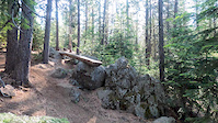
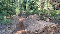
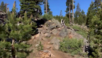
Popular Wanoga Mountain Biking Trails
• 100 ★ 4.4 • 4 miles • 79 ft • 4,805 •
This is the super fun section of Tiddlywinks. Flowy berms and tabletops make for huge grins all around. Nothing scary or technical about this part of the trail, just fun.
• 100 ★ 3.9 • 1,535 ft • 99 ft • 4,534 •
A short Uphill Only segment of the . Nothing technical. Takes you to the start of proper.
• 90 ★ 4.4 • 4 miles • 10 ft • 3,837 •
is pretty darn fun :) From Wanoga, it starts low angle, open and flowy. Be prepared for some tech rocks, a slalom style turn section and some optional log rides. The second half has some bigger rock features, rock drops and challenging...
• 100 ★ 3.3 • 1,108 ft • 77 ft • 3,351 •
Quick Access trail from Tyler's parking to the climbing road.
• 95 ★ 3.9 • 3 miles • 160 ft • 3,194 •
This is really a transfer trail from the Wanoga snowpark to what us local refer to as Tiddlywinks. So if you get on this expecting a downhill trail, have no fear, you will get to the goods in about 10-15 min. Trail has a fun start into...
• 95 ★ 4.0 • 823 ft • 0 ft • 3,131 •
Highly rated popular black diamond difficulty singletrack. This mountain bike primary trail can be used both directions. It features drop and log ride. On average it takes 1 minutes to complete this trail.
• 100 ★ 3.6 • 1 mile • 286 ft • 2,721 •
Climbing route that Parallels . Keeps to DH traffic only.
Wanoga Mountain Bike Routes
★ 5.0 • 13 miles • 1,594 ft • 12 • Loop •
Overview With a doubletrack climb, Tyler’s Traverse is all gain with little pain. Once you start the...
★ 5.0 • 13 miles • 1,542 ft • 3 •
from skyliners take tumalo creek up to swede ridge and back down south fork
★ 4.4 • 12 miles • 1,346 ft • 2 •
10 Barrel Riding Solo Series (Fall 2020) - Week 1 Short Course
★ 5.0 • 26 miles • 1,951 ft • 6 • Shuttled •
Endless fast and flowy downhill interrupted perfectly by an entertaining climb passing countless scenic...
★ 5.0 • 13 miles • 1,444 ft • 3 •
Big views from Tumalo Ridge
★ 4.0 • 25 miles • 1,343 ft • 21 • Shuttled •
A route for doing South Fork, by using shuttle to get to Swampy Lakes as your starting point, and...
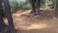
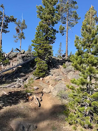
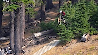
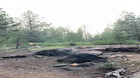
Photos of Wanoga Mountain Bike
Videos of Wanoga Mountain Bike
trail: Ponderosa (Pondo)
0:11 |
56 |
Nov 19, 2025
trail: Tiddlywinks (Upper)
0:10 |
356 |
Jun 3, 2023
trail: Lone Wolf
3:36 |
600 |
Oct 18, 2021
trail: Funner
0:08 |
173 |
Jul 19, 2021

trail: Lone Wolf
0:53 |
13227 |
Jul 6, 2021
trail: Funner DH
0:12 |
558 |
Aug 2, 2020
trail: Tiddlywinks (Lower)
0:07 |
1017 |
Nov 9, 2019
trail: Lone Wolf
0:45 |
1541 |
Aug 20, 2019
Recent Trail Reports
| status | trail | date | condition | info | user |
|---|---|---|---|---|---|
| Funner | Jun 20, 2026 @ 6:16pm (America/Los_Angeles) Jun 20, 2026 | Dry | ddocky | ||
| Gimme Two! | Jun 16, 2026 @ 10:54am (America/Boise) Jun 16, 2026 | Very Dry | scottf2 | ||
| Tyler's Traverse | Jun 16, 2026 @ 9:31am (America/Los_Angeles) Jun 16, 2026 | Dry | HMo4Z | ||
| Tyler's Traverse Uphill Route | Jun 10, 2026 @ 9:22am (America/Los_Angeles) Jun 10, 2026 | Ideal | Drhumphrey | ||
| Tyler's Uphill Access | Jun 10, 2026 @ 9:22am (America/Los_Angeles) Jun 10, 2026 | Ideal | Drhumphrey | ||
| Lone Wolf | May 24, 2026 @ 9:00am (America/Boise) May 24, 2026 | Very Dry | mtn-rider07 | ||
| Tyler's Traverse Uphill Route | May 24, 2026 @ 9:00am (America/Boise) May 24, 2026 | Dry | mtn-rider07 | ||
| Access Road | May 24, 2026 @ 9:00am (America/Boise) May 24, 2026 | Dry | mtn-rider07 | ||
| Catch and Release | May 22, 2026 @ 5:39am (America/Los_Angeles) May 22, 2026 | Dry | StevoLDevo | ||
| Tiddlywinks (Lower) | May 15, 2026 @ 12:44pm (America/Los_Angeles) May 15, 2026 | Dry | jaredmh |
Activity Feed
| username | action | type | title | date |
|---|---|---|---|---|
| Johnpcunningham | wishlist | trail | activity #97666076 and 1 more | Jun 23, 2026 @ 6:19pm 1 day |
| Ryanvgf91e | ridden | trail | activity #97650205 | Jun 23, 2026 @ 1:45pm 1 day |
| schyler | wishlist | route | activity #97622305 | Jun 23, 2026 @ 6:28am 2 days |
| rpidge | wishlist | region | activity #97600388 | Jun 22, 2026 @ 7:41pm 2 days |
| WyIM3pZV | wishlist | route | activity #97595308 | Jun 22, 2026 @ 5:47pm 2 days |
Recent Comments
| username | type | title | comment | date |
|---|---|---|---|---|
| trail | This is a really fun trail and quickly became... | May 19, 2026 @ 10:43am May 19, 2026 | ||
| trail | Starting tomorrow, Friday, May 1, a portion of... | May 9, 2026 @ 11:41pm May 9, 2026 | ||
| trail | This is a good trail, fun change of pace.... | May 8, 2026 @ 3:52pm May 8, 2026 | ||
| trail | Full of dingus e bikers | Apr 25, 2026 @ 6:00pm Apr 25, 2026 | ||
| report | Froth lord | Oct 30, 2025 @ 3:55pm Oct 30, 2025 |
Nearby Areas
| name | distance | ||||
|---|---|---|---|---|---|
| Wango Sno-Park | 3 | 1 | 1 km | ||
| Swampy Sno-Park | 4 | 7 | 1.7 km | ||
| Edison Butte | 1 | 2 | 4.7 km | ||
| Phil's | 39 | 26 | 7 | 2 | 6.3 km |
| Dutchman Flat Sno-Park | 1 | 6 | 7.3 km |
Local Badges
-

Completionist0 awarded
Bike & Skill Parks
| name | type | city | rating |
|---|---|---|---|
| Wanoga Infield Bike Park Skills Area | skill park | Bend |
Local Products
Activity Type Stats
| activitytype | trails | distance | descent | descent distance | total vertical | rating | global rank | state rank | photos | reports | routes | ridelogs |
|---|---|---|---|---|---|---|---|---|---|---|---|---|
| Mountain Bike | 29 | 55 miles | 7,126 ft | 25 miles | 1,713 ft | #282 | #100 | 337 | 1,216 | 42 | 38,806 | |
| E-Bike | 17 | #5,251 | #1,452 | 792 | 1 | 706 | ||||||
| Hike | 22 | 47 miles | 4,495 ft | 18 miles | 1,713 ft | #4,467 | #1,593 | 1,081 | 319 | |||
| Trail Running | 22 | 47 miles | 4,495 ft | 18 miles | 1,713 ft | #3,643 | #1,000 | 1,089 | 99 |
Frequently Asked Questions About Wanoga
▼
What are the highest rated mountain biking trails in Wanoga?
The highest rated mountain biking trails in Wanoga are:
- Tyler's Traverse (4.5/5)
- Funner DH (4.4/5)
- 50 Shades of Blue (4.4/5)
- Tiddlywinks (Lower) (4.4/5)
- Lone Wolf (4.4/5)
▼
What is the best time of the year to ride in Wanoga?
Based on ride log data, the most popular months to ride in Wanoga are:
- July (976 activities)
- June (744 activities)
- May (655 activities)
▼
Where can I park to ride in Wanoga?
There are 1 parking locations listed in Wanoga. The most popular parking spots are:
▼
What is the longest trail in Wanoga?
The longest trail in Wanoga is Tyler's Traverse at 6.7 miles. View all trails sorted by distance.
Activities
Trails
- By n-skinner
 & contributors
 - Admins: COTA, COTA
- #19213 - 23,993 views
- wanoga activity log | embed map of Wanoga mountain bike trails | wanoga mountain biking points of interest polygons
Downloading of trail gps tracks in kml & gpx formats is enabled for Wanoga.
You must login to download files.