close
-
Layers w
- Weather Layers
- Pro
- Pro
- Pro
- Pro
- Pro
- Pro
- More Layers
- Pro
- Pro
- Pro
- Pro
-
Upgrade to

3D
Trail Conditions
- Unknown
- Snow Groomed
- Snow Packed
- Snow Covered
- Snow Cover Partial
- Freeze/thaw Cycle
- Icy
- Prevalent Mud
- Wet
- Variable
- Ideal
- Dry
- Very Dry
Trail Flow (Ridden Direction)
Trailforks scans users ridelogs to determine the most popular direction each trail is ridden. A good flowing trail network will have most trails flowing in a single direction according to their intension.
The colour categories are based on what percentage of riders are riding a trail in its intended direction.
The colour categories are based on what percentage of riders are riding a trail in its intended direction.
- > 96%
- > 90%
- > 80%
- > 70%
- > 50%
- < 50%
- bi-directional trail
- no data
Trail Last Ridden
Trailforks scans ridelogs to determine the last time a trail was ridden.
- < 2 days
- < 1 week
- < 2 weeks
- < 1 month
- < 6 months
- > 6 months
Trail Ridden Direction
The intended direction a trail should be ridden.
- Downhill Only
- Downhill Primary
- Both Directions
- Uphill Primary
- Uphill Only
- One Direction
Contribute Details
Colors indicate trail is missing specified detail.
- Description
- Photos
- Description & Photos
- Videos
Trail Popularity ?
Trailforks scans ridelogs to determine which trails are ridden the most in the last 9 months.
Trails are compared with nearby trails in the same city region with a possible 25 colour shades.
Think of this as a heatmap, more rides = more kinetic energy = warmer colors.
- most popular
- popular
- less popular
- not popular
ATV/ORV/OHV Filter
Max Vehicle Width
inches
US Cell Coverage
Legend

Radar Time
Activity Recordings
Trailforks uses anonymized public activity data.
?
Activity Recordings
Trailforks uses anonymized public activity data.
?
Personal Heatmap
▶
Activity Types
all
/
none
▶
Options
2
Date range
month
–
Winter Trails
Warning
A routing network for winter maps does not exist. Selecting trails using the winter trails layer has been disabled.
Missing Trails
Most Popular
Least Popular
Trails are colored based on popularity. The more popular a trail is, the more red. Less popular trails trend towards green.
Jump Magnitude Heatmap
Heatmap of where riders jump on trails. Zoom in to see individual jumps, click circles to view jump details.
BC Backroad Status
![map legend]()
Service Road Atlas is a free to use, community-driven service for viewing and creating reports on the numerous back-country service roads around B.C. and Alberta.

Slope Aspect
Direction the slope faces
Trails Deemphasized
Trails are shown in grey.
Only show trails with no bike usage.
Suggested Layers
Based on selected activity type
Save the current map location and zoom level as your default home location whenever this page is loaded.
Save
No description for Waterton has been added yet!
Login or register to submit one.
Activities Click to view
- Mountain Bike
14 trails
- E-Bike
5 trails
- Gravel Bike
0 trails
- Adaptive Bike
0 trails
- Horse
5 trails
- Hike
93 trails
- Trail Running
93 trails
- Snowshoe
15 trails
- Backcountry Ski
5 trails
Region Details
- 2
- 2
- 10
Region Status
Open as of May 16, 2026Stats
- Avg Trail Rating
- Trails (view details)
- 93
- Trails Mountain Bike
- 14
- Trails E-Bike
- 5
- Trails Horse
- 5
- Trails Hike
- 93
- Trails Trail Running
- 93
- Trails Snowshoe
- 15
- Trails Backcountry Ski
- 5
- Total Distance
- 244 miles
- Total Descent
- 66,223 ft
- Total Vertical
- 4,638 ft
- Highest Trailhead
- 8,650 ft
- Reports
- 107
- Photos
- 110
- Ridden Counter
- 3,958
Sub Regions
-
Waterton Lakes National Park
- 1
- 7
Popular Waterton Mountain Biking Trails
• 95 ★ 3.8 • 5 miles • 929 ft • 87 •
Popular blue difficulty singletrack. This multi-use trail can be used both directions and has a moderate overall physical rating with a 929 ft blue climb. It features drop, jump, gap jump and ladder bridge. On average it takes 1 hour20 minutes to complete this trail.
• 90 ★ 4.4 • 5 miles • 1,010 ft • 56 •
The most technical of the mountain bike trails in Waterton. This trail starts in the Crandell campground, off the Red Rock Parkway. It then climbs up to , then continues over a small pass before descending to parallel the Akamina...
• 100 ★ 3.0 • 2 miles • 395 ft • 44 •
A very picturesque trail after the fire - great visibility. Some loose rock. Starts off as double track but narrows to single track around the 1/2 way point. All bridges and structures were very nicely rebuilt after the fire.
• 65 ★ 0.0 • 3,573 ft • 234 ft • 38 •
Moderately popular blue difficulty singletrack. This multi-use trail can be used uphill primary and has a hard overall physical rating with a 234 ft blue climb. Trail visibility is always easy to follow. On average it takes 12 minutes to complete this trail.
• 75 ★ 0.0 • 1,086 ft • 49 ft • 36 •
Popular blue difficulty singletrack. This multi-use trail can be used both directions and has a moderate overall physical rating with a 49 ft blue climb. On average it takes 5 minutes to complete this trail.
• 45 ★ 2.0 • 4 miles • 148 ft • 28 •
This is a rolling open single track mainly used as access to Hiking trials in the area - also expect equestrian activity and evidence
• 80 ★ 0.0 • 2 miles • 252 ft • 20 •
Popular blue difficulty singletrack. This multi-use trail can be used both directions.
• 50 ★ 4.0 • 1 mile • 908 ft • 11 • • hike
Moderately popular blue difficulty singletrack. This hike primary trail can be used both directions.
Waterton Mountain Bike Routes
• 8 miles • 260 ft • 2 •
• 7 miles • 1,102 ft • 3 •
• 5 miles • 83 ft • 0 •
• 14 miles • 891 ft • 0 •
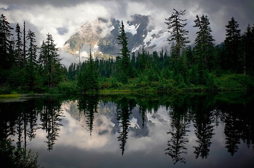
Photos of Waterton Mountain Bike
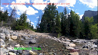
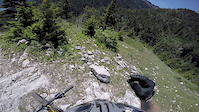
Videos of Waterton Mountain Bike
trail: SnowShoe
0:01 |
388 |
Jul 9, 2017
trail: Crandell Lake Trail
4:52 |
844 |
Jan 22, 2017

trail: Boulder Pass
1:9:54 |
1012 |
Jun 2, 2019 , Waterton
Recent Trail Reports
| status | trail | date | condition | info | user |
|---|---|---|---|---|---|
| Crandell Lake Trail | May 16, 2026 @ 7:45pm (America/Edmonton) May 16, 2026 | Variable | michael-coyle | ||
| Wall Lake Trail | Jun 14, 2025 @ 7:29pm Jun 14, 2025 | Ideal | eoiner | ||
| SnowShoe | May 31, 2025 @ 4:46pm May 31, 2025 | Unknown | spoke-too-soon | ||
| Bertha Lake Trail | Jul 18, 2024 @ 1:18am Jul 18, 2024 | Ideal | Schoeggi22 | ||
| Crandell Lake Trail - Akamina Access | Jun 27, 2024 @ 6:19pm Jun 27, 2024 | Unknown | spoke-too-soon | ||
| Akamina Pass Trail | Oct 9, 2022 @ 8:54am Oct 9, 2022 | Dry | BbOsV | ||
| Wishbone | Sep 27, 2022 @ 11:17am Sep 27, 2022 | Ideal | mkrogen | ||
| Forum Falls | Aug 16, 2021 @ 11:31am Aug 16, 2021 | Very Dry | revelations |
National Scenic Trails & Official Routes
-
Continental Divide Trail
- Mountain Bike
- Hike
- Trail Running
-
Pacific Northwest Trail
- Mountain Bike
- Horse
- Hike
- Trail Running

Activity Feed
| username | action | type | title | date |
|---|---|---|---|---|
| michael-coyle | add | report | activity #94867877 | May 16, 2026 @ 6:45pm May 16, 2026 |
| rockystumpy | add | report | activity #90865451 | Mar 19, 2026 @ 10:09am Mar 19, 2026 |
| elsieoutthere | wishlist | trail | activity #90716096 | Mar 16, 2026 @ 5:10pm Mar 16, 2026 |
| prairiebiker79 | wishlist | trail | activity #85241364 | Dec 7, 2025 @ 4:26pm Dec 7, 2025 |
| grahamtyler | wishlist | trail | activity #84486512 | Nov 21, 2025 @ 8:50am Nov 21, 2025 |
Recent Comments
| username | type | title | comment | date |
|---|---|---|---|---|
| trail | Pretty sure this is hiking only, no bikes allowed. | Aug 3, 2025 @ 9:16pm Aug 3, 2025 | ||
| trail | Hello, Does anyone know if the avg time of... | Aug 28, 2024 @ 8:51am Aug 28, 2024 | ||
| trail | Clear all the way. Great ride fast down but... | Jun 22, 2023 @ 5:48pm Jun 22, 2023 | ||
| trail | Nice | Jun 3, 2023 @ 2:00pm Jun 3, 2023 | ||
| trail | Was there on a spectacular fall day. Colours... | Oct 9, 2022 @ 8:50am Oct 9, 2022 |
Local Badges
-

Epic Ride Climb 2k7 awarded -

Climbing 10k Badge2 awarded -

Climbing 100k Badge0 awarded -

Epic Ride Descent 2k7 awarded -

Descent 10k Badge2 awarded -

Descent 100k Badge0 awarded
Activity Type Stats
| activitytype | trails | distance | descent | descent distance | total vertical | rating | global rank | state rank | photos | reports | routes | ridelogs |
|---|---|---|---|---|---|---|---|---|---|---|---|---|
| Mountain Bike | 14 | 32 miles | 3,825 ft | 11 miles | 2,192 ft | #6,218 | #48 | 81 | 103 | 1 | 1,690 | |
| E-Bike | 5 | 12 miles | 1,667 ft | 4 miles | 1,624 ft | #5,669 | #40 | 93 | 96 | |||
| Horse | 5 | 12 miles | 1,499 ft | 4 miles | 1,621 ft | #1,944 | #21 | 24 | 5 | |||
| Hike | 93 | 244 miles | 66,224 ft | 91 miles | 4,639 ft | #261 | #6 | 29 | 107 | 2,921 | ||
| Trail Running | 93 | 244 miles | 66,224 ft | 91 miles | 4,639 ft | #601 | #7 | 107 | 316 | |||
| Snowshoe | 15 | 23 miles | 4,049 ft | 5 miles | 3,970 ft | #718 | #21 | 1 | 22 | |||
| Backcountry Ski | 5 | 9 miles | 446 ft | 3,350 ft | 3,458 ft | #527 | #16 | 93 |
Frequently Asked Questions About Waterton
▼
What are the best places to ride in Waterton?
Waterton has 3 areas to explore for mountain biking. The top rated areas are:
▼
What are the highest rated mountain biking trails in Waterton?
The highest rated mountain biking trails in Waterton are:
- Crandell Lake Trail (4.2/5)
- Bertha Lake Trail (4/5)
- SnowShoe (3.9/5)
- Akamina Pass Trail (3.7/5)
- Wishbone (3.5/5)
▼
What is the best time of the year to ride in Waterton?
Based on ride log data, the most popular months to ride in Waterton are:
- August (31 activities)
- July (30 activities)
- June (27 activities)
▼
Where can I park to ride in Waterton?
Activities
Trails
- By chasingjoy
 & contributors
 - Admins: apply
- #5595 - 15,046 views
- waterton activity log | embed map of Waterton mountain bike trails | waterton mountain biking points of interest
Downloading of trail gps tracks in kml & gpx formats is enabled for Waterton.
You must login to download files.