close
-
Layers w
- Weather Layers
- Pro
- Pro
- Pro
- Pro
- Pro
- Pro
- More Layers
- Pro
- Pro
- Pro
- Pro
-
Upgrade to

3D
Trail Conditions
- Unknown
- Snow Groomed
- Snow Packed
- Snow Covered
- Snow Cover Partial
- Freeze/thaw Cycle
- Icy
- Prevalent Mud
- Wet
- Variable
- Ideal
- Dry
- Very Dry
Trail Flow (Ridden Direction)
Trailforks scans users ridelogs to determine the most popular direction each trail is ridden. A good flowing trail network will have most trails flowing in a single direction according to their intension.
The colour categories are based on what percentage of riders are riding a trail in its intended direction.
The colour categories are based on what percentage of riders are riding a trail in its intended direction.
- > 96%
- > 90%
- > 80%
- > 70%
- > 50%
- < 50%
- bi-directional trail
- no data
Trail Last Ridden
Trailforks scans ridelogs to determine the last time a trail was ridden.
- < 2 days
- < 1 week
- < 2 weeks
- < 1 month
- < 6 months
- > 6 months
Trail Ridden Direction
The intended direction a trail should be ridden.
- Downhill Only
- Downhill Primary
- Both Directions
- Uphill Primary
- Uphill Only
- One Direction
Contribute Details
Colors indicate trail is missing specified detail.
- Description
- Photos
- Description & Photos
- Videos
Trail Popularity ?
Trailforks scans ridelogs to determine which trails are ridden the most in the last 9 months.
Trails are compared with nearby trails in the same city region with a possible 25 colour shades.
Think of this as a heatmap, more rides = more kinetic energy = warmer colors.
- most popular
- popular
- less popular
- not popular
ATV/ORV/OHV Filter
Max Vehicle Width
inches
US Cell Coverage
Legend

Radar Time
Activity Recordings
Trailforks uses anonymized public activity data.
?
Activity Recordings
Trailforks uses anonymized public activity data.
?
Personal Heatmap
▶
Activity Types
all
/
none
▶
Options
2
Date range
month
–
Winter Trails
Warning
A routing network for winter maps does not exist. Selecting trails using the winter trails layer has been disabled.
Missing Trails
Most Popular
Least Popular
Trails are colored based on popularity. The more popular a trail is, the more red. Less popular trails trend towards green.
Jump Magnitude Heatmap
Heatmap of where riders jump on trails. Zoom in to see individual jumps, click circles to view jump details.
BC Backroad Status
![map legend]()
Service Road Atlas is a free to use, community-driven service for viewing and creating reports on the numerous back-country service roads around B.C. and Alberta.

Slope Aspect
Direction the slope faces
Trails Deemphasized
Trails are shown in grey.
Only show trails with no bike usage.
Suggested Layers
Based on selected activity type
Save the current map location and zoom level as your default home location whenever this page is loaded.
Save
No description for Weber County has been added yet!
Login or register to submit one.
Activities Click to view
- Mountain Bike
328 trails
- E-Bike
93 trails
- Horse
16 trails
- Hike
265 trails
- Trail Running
263 trails
- Dirtbike/Moto
17 trails
- ATV/ORV/OHV
3 trails
- Snowmobile
1 trails
- Snowshoe
33 trails
- Downhill Ski
380 trails
- Backcountry Ski
0 trails
- Nordic Ski
39 trails
Region Details
- 47
- 24
- 85
- 120
- 37
- 6
- 2
Stats
- Avg Trail Rating
- Trails (view details)
- 758
- Trails Mountain Bike
- 329
- Trails E-Bike
- 93
- Trails Horse
- 16
- Trails Hike
- 265
- Trails Trail Running
- 263
- Trails Dirtbike/Moto
- 17
- Trails ATV/ORV/OHV
- 3
- Trails Snowmobile
- 1
- Trails Snowshoe
- 33
- Trails Downhill Ski
- 380
- Trails Nordic Ski
- 39
- Total Distance
- 607 miles
- Total Descent
- 235,647 ft
- Total Vertical
- 5,413 ft
- Highest Trailhead
- 9,628 ft
- Reports
- 5,585
- Photos
- 1,453
- Ridden Counter
- 199,079
Sub Regions
- Avon (1)
- Eden (86)
- Huntsville (72)
- Causey Reservoir (6)
- Snowbasin Resort (59)
- Kaysville (30)
- North Ogden (16)
- Ogden (142)
- West Haven (4)
- West Point (8)
Popular Weber County Mountain Biking Trails
• 100 ★ 4.5 • 1 mile • 562 ft • 2,352 •
Awesome trail with an optional look-out of Ogden as well as views of Pineview Reservoir at the top. Preferred riding direction is clockwise with flowing switch-backs descending into a grove of trees below. Trail is used by hikers and...
• 95 ★ 3.1 • 518 ft • 42 ft • 1,948 •
Short connector from the access road to the Sardine singletrack.
• 90 ★ 3.3 • 2 miles • 26 ft • 1,929 •
This trail is considered an easy downhill trail, but it can be a difficult climb. When the lifts run during the weekend, this trail gets a lot of downhill traffic because of its great flow and tight but big berms at the bottom. Some...
• 95 ★ 4.8 • 1,896 ft • 0 ft • 1,734 •
Popular green difficulty singletrack. This mountain bike primary trail can be used both directions. On average it takes 4 minutes to complete this trail.
• 90 ★ 4.1 • 3 miles • 874 ft • 1,316 •
The original trail has been re-aligned in some areas, and some switchbacks have been added easing the climb slightly. Most of the work was done to reduce erosion. Work was completed August, 2019.
• 90 ★ 4.4 • 3,176 ft • 229 ft • 1,232 •
Steep trail with switchbacks out to an amazing over the Ogden Valley.
• 90 ★ 4.4 • 2 miles • 531 ft • 1,200 •
Of of the highlights of the trails. Lush riding through the tree's with a pretty little lake/pond in the middle. Lots of undulations and the occasional rocky patch keep it interesting.
Weber County Mountain Bike Routes
★ 3.7 • 34 miles • 5,108 ft • 649 • Loop •
This is the 50 k lap from the Mt ogden 100k race.
★ 5.0 • 6 miles • 668 ft • 6 • Loop •
CCW TH loop. trail rock gardens up, then down for some smoother single track.
★ 5.0 • 6 miles • 470 ft • 1 •
★ 3.0 • 20 miles • 3,197 ft • 12 •
Big Loop of Area. Includes Lower , Sardine Loop, / Upper Wheeler, Art Nord / , ,
★ 5.0 • 21 miles • 3,306 ft • 11 • Loop •
Clockwise route of the 'Rooster Ride'. CW is suggested.
★ 5.0 • 19 miles • 2,979 ft • 16 • Loop •
Nice ride starting at to , then up to and finish it off with .
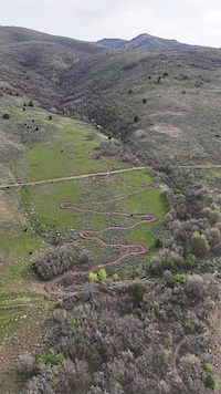
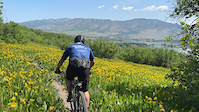
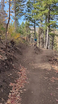
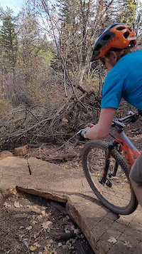
Photos of Weber County Mountain Bike
Videos of Weber County Mountain Bike
trail: Sidewinder
0:34 |
33 |
Apr 22, 2026
trail: Green Mile
0:12 |
6 |
Jun 6, 2025
trail: Moose Tracks
0:05 |
|
Oct 14, 2024
trail: Moose Tracks
0:06 |
|
Oct 14, 2024
trail: East Fork
0:24 |
12 |
Jul 20, 2023
trail: Spork
0:07 |
517 |
Nov 12, 2022
trail: Coldwater Canyon (BST)
8:18 |
31 |
Nov 10, 2021
trail: Stairway to Harrison
7:48 |
85 |
Nov 4, 2020
Current Trail Warnings
| status | trail | date | condition | user | info |
|---|---|---|---|---|---|
| Baggage Claim Powder Mountain Resort | Jun 29, 2026 @ 2:43pm (America/Denver) 1 day | Very Dry | elliottred | Trail is closed for summer 2026 due to... | |
| Brim Trail Re Route for Summer Construction 2024 Eden | Jun 29, 2026 @ 2:41pm (America/Denver) 1 day | Unknown | elliottred | Brim Trail is closed for summer 2026 due... | |
| Strong's Canyon Ogden | Jun 10, 2026 @ 6:37pm (America/Boise) Jun 10, 2026 | Dry | drewmorelock | In terms of mountain biking, don't. This... |
Recent Trail Reports
National Scenic Trails & Official Routes
-
Bonneville Shoreline Trail
- Mountain Bike
- E-Bike
- Horse
- Hike
- Trail Running
- Snowshoe
- Nordic Ski
-
Great Western Trail
- Mountain Bike
- E-Bike
- Horse
- Hike
- Trail Running
- Dirtbike/Moto
- ATV/ORV/OHV


Activity Feed
| username | action | type | title | date |
|---|---|---|---|---|
| pigmower | wishlist | trail | activity #98145099 | Jun 30, 2026 @ 11:25am 10 hours |
| jas9smith | wishlist | route | activity #98088621 | Jun 29, 2026 @ 2:53pm 1 day |
| kmregan45 | wishlist | trail | activity #98087670 | Jun 29, 2026 @ 2:34pm 1 day |
| elliottred | add | report | activity #98085149 | Jun 29, 2026 @ 1:43pm 1 day |
| elliottred | add | report | activity #98085074 | Jun 29, 2026 @ 1:42pm 1 day |
Recent Comments
| username | type | title | comment | date |
|---|---|---|---|---|
| trail | True Mountain bikers would classify this as... | Jun 28, 2026 @ 11:28am 2 days | ||
| trail | Still washed out and unavailable from the... | Jun 17, 2026 @ 8:07pm Jun 17, 2026 | ||
| report | nfcz FUa with zmy girl Di a Harper yet txy n | Jun 15, 2026 @ 10:52am Jun 15, 2026 | ||
| trail | Closed 6/15 for machine work | Jun 15, 2026 @ 10:43am Jun 15, 2026 | ||
| trail | Rode Needles this morning and ran into 3... | Jun 11, 2026 @ 1:31pm Jun 11, 2026 |
Local Badges
-

Completionist1 awarded -
Completionist0 awarded -

Descent 100k Badge1 awarded -

Descent 10k Badge77 awarded -

Epic Ride Descent 2k102 awarded -

10 Green Trails501 awarded
Bike & Skill Parks
| name | type | city | rating |
|---|---|---|---|
| Ogden Bike Park Pumptrack | skill park | Ogden | |
| Trackline Bike Park | skill park | Ogden | |
| 12th Street BMX jumps | skill park | Ogden | |
| Riverdale Pump Track | skill park | Ogden | |
| Ogden Cyclocross Park | skill park | Ogden |
Upcoming Local Events
Activity Type Stats
| activitytype | trails | distance | descent | descent distance | total vertical | rating | global rank | state rank | photos | reports | routes | ridelogs |
|---|---|---|---|---|---|---|---|---|---|---|---|---|
| Mountain Bike | 328 | 395 miles | 65,728 ft | 164 miles | 5,413 ft | 1,335 | 5,580 | 97 | 125,655 | |||
| E-Bike | 93 | 140 miles | 17,100 ft | 59 miles | 4,662 ft | 2 | 4,457 | 10 | 6,959 | |||
| Horse | 16 | 28 miles | 5,417 ft | 12 miles | 5,226 ft | 83 | 1,000 | 4 | 17 | |||
| Hike | 265 | 337 miles | 47,520 ft | 125 miles | 5,413 ft | 36 | 5,344 | 57 | 10,274 | |||
| Trail Running | 263 | 329 miles | 47,638 ft | 124 miles | 5,413 ft | 1 | 5,324 | 57 | 11,297 | |||
| Dirtbike/Moto | 17 | 42 miles | 9,787 ft | 23 miles | 5,226 ft | 987 | 3 | 146 | ||||
| ATV/ORV/OHV | 3 | 14 miles | 1,220 ft | 3 miles | 2,205 ft | 957 | 1 | 24 | ||||
| Snowmobile | 1 | 3 miles | 1,588 ft | 13 | 11 | |||||||
| Snowshoe | 33 | 50 miles | 6,798 ft | 17 miles | 3,031 ft | 371 | 21 | 451 | ||||
| Downhill Ski | 380 | 168 miles | 165,843 ft | 159 miles | 3,990 ft | 26 | 16,590 | |||||
| Nordic Ski | 39 | 17 miles | 2,159 ft | 7 miles | 495 ft | 16 | 1,010 |
Frequently Asked Questions About Weber County
▼
What are the best places to ride in Weber County?
Weber County has 15 areas to explore for mountain biking. The top rated areas are:
▼
What are the highest rated mountain biking trails in Weber County?
The highest rated mountain biking trails in Weber County are:
- Canyon Rim Trail Race Loop (4.6/5)
- The Rut (4.5/5)
- Cutlers' Twist (4.5/5)
- Sardine Peak (4.5/5)
- Sardine Peak (4.5/5)
▼
What is the best time of the year to ride in Weber County?
Based on ride log data, the most popular months to ride in Weber County are:
- July (2,041 activities)
- August (1,449 activities)
- June (1,259 activities)
▼
What is the longest trail in Weber County?
The longest trail in Weber County is Weber River Parkway at 10.5 miles. View all trails sorted by distance.
Activities
Trails
Points of Interest
- By brenthillier
 NSMBA TRAILFORKS & contributors
 - Admins: jkwilliamz, UtahJohn, jpmcghee, jasonmalczyk
- #15484 - 15,133 views
- weber county activity log | embed map of Weber County mountain bike trails | weber county mountain biking points of interest
Downloading of trail gps tracks in kml & gpx formats is enabled for Weber County.
You must login to download files.