close
-
Layers w
- Weather Layers
- Pro
- Pro
- Pro
- Pro
- Pro
- Pro
- More Layers
- Pro
- Pro
- Pro
- Pro
-
Upgrade to

3D
Trail Conditions
- Unknown
- Snow Groomed
- Snow Packed
- Snow Covered
- Snow Cover Partial
- Freeze/thaw Cycle
- Icy
- Prevalent Mud
- Wet
- Variable
- Ideal
- Dry
- Very Dry
Trail Flow (Ridden Direction)
Trailforks scans users ridelogs to determine the most popular direction each trail is ridden. A good flowing trail network will have most trails flowing in a single direction according to their intension.
The colour categories are based on what percentage of riders are riding a trail in its intended direction.
The colour categories are based on what percentage of riders are riding a trail in its intended direction.
- > 96%
- > 90%
- > 80%
- > 70%
- > 50%
- < 50%
- bi-directional trail
- no data
Trail Last Ridden
Trailforks scans ridelogs to determine the last time a trail was ridden.
- < 2 days
- < 1 week
- < 2 weeks
- < 1 month
- < 6 months
- > 6 months
Trail Ridden Direction
The intended direction a trail should be ridden.
- Downhill Only
- Downhill Primary
- Both Directions
- Uphill Primary
- Uphill Only
- One Direction
Contribute Details
Colors indicate trail is missing specified detail.
- Description
- Photos
- Description & Photos
- Videos
Trail Popularity ?
Trailforks scans ridelogs to determine which trails are ridden the most in the last 9 months.
Trails are compared with nearby trails in the same city region with a possible 25 colour shades.
Think of this as a heatmap, more rides = more kinetic energy = warmer colors.
- most popular
- popular
- less popular
- not popular
ATV/ORV/OHV Filter
Max Vehicle Width
inches
US Cell Coverage
Legend

Radar Time
Activity Recordings
Trailforks uses anonymized public activity data.
?
Activity Recordings
Trailforks uses anonymized public activity data.
?
Personal Heatmap
▶
Activity Types
all
/
none
▶
Options
2
Date range
month
–
Winter Trails
Warning
A routing network for winter maps does not exist. Selecting trails using the winter trails layer has been disabled.
Missing Trails
Most Popular
Least Popular
Trails are colored based on popularity. The more popular a trail is, the more red. Less popular trails trend towards green.
Jump Magnitude Heatmap
Heatmap of where riders jump on trails. Zoom in to see individual jumps, click circles to view jump details.
BC Backroad Status
![map legend]()
Service Road Atlas is a free to use, community-driven service for viewing and creating reports on the numerous back-country service roads around B.C. and Alberta.

Slope Aspect
Direction the slope faces
Trails Deemphasized
Trails are shown in grey.
Only show trails with no bike usage.
Suggested Layers
Based on selected activity type
Save the current map location and zoom level as your default home location whenever this page is loaded.
Save
No description for West Yellowstone has been added yet!
Login or register to submit one.
Activities Click to view
- Mountain Bike
67 trails
- E-Bike
13 trails
- Gravel Bike
0 trails
- Adaptive Bike
0 trails
- Winter Fat Bike
5 trails
- Horse
31 trails
- Hike
70 trails
- Trail Running
69 trails
- Dirtbike/Moto
11 trails
- ATV/ORV/OHV
8 trails
- Snowmobile
4 trails
- Snowshoe
17 trails
- Backcountry Ski
6 trails
- Nordic Ski
16 trails
Region Details
- 9
- 2
- 7
- 27
- 8
Region Status
Caution as of 22 hoursStats
- Avg Trail Rating
- Trails (view details)
- 58
- Trails Mountain Bike
- 67
- Trails E-Bike
- 13
- Trails Winter Fat Bike
- 5
- Trails Horse
- 31
- Trails Hike
- 70
- Trails Trail Running
- 69
- Trails Dirtbike/Moto
- 11
- Trails ATV/ORV/OHV
- 8
- Trails Snowmobile
- 4
- Trails Snowshoe
- 17
- Trails Backcountry Ski
- 6
- Trails Nordic Ski
- 16
- Total Distance
- 203 miles
- Total Descent
- 18,880 ft
- Total Vertical
- 4,696 ft
- Highest Trailhead
- 10,002 ft
- Reports
- 277
- Photos
- 343
- Ridden Counter
- 3,726
Articles
Exploring the Mountaintop Trails of Idaho & Montana
May 18, 2019 from pinkbike.com
Taking a road trip to some of the best trails along the border of Idaho and Montana.
Sub Regions
-
Lionhead
- 10
- 5
-
Rendezvous Trails
- 2
- 10
- 2
-
Two Top Mountain
- 1
- 3
- 7
Popular West Yellowstone Mountain Biking Trails
• 100 ★ 4.8 • 5 miles • 2,208 ft • 214 •
Artfully built climb to the state line. The rock work is impressive, the grade is moderate and the switchbacks are rideable.
• 95 ★ 4.2 • 4 miles • 922 ft • 155 •
Beautiful high alpine single track. Climbs steadily for the first 1-2 miles then flows up and down from there. Trail eventually connects to the dirt road that take you to the Two-Top summit. Generally ridden as an out and back, starting...
• 100 ★ 0.0 • 5,236 ft • 255 ft • 132 •
Popular blue difficulty singletrack. This multi-use trail can be used both directions. On average it takes 12 minutes to complete this trail.
• 90 ★ 5.0 • 14 miles • 4,166 ft • 128 •
This trail is an astounding backcountry experience in the Henry Lake Mountains outside of West Yellowstone, MT. This area is on a short list for wilderness designations so ride it now and hopefully we wont lose a classic piece of MT/ID...
• 75 ★ 4.2 • 6 miles • 2,521 ft • 108 •
From the trailhead the trail climbs and flows with some bridges and mandatory creek crossings. You can expect things to get steeper and more technical the further up you go. The trail does have a number of root and rock step ups and...
• 85 ★ 5.0 • 6 miles • 2,575 ft • 88 •
Incredible ride into the dome, insanely beautiful high country. Runs along the stream with little tech sections before it starts climb up into everything we should protect for knobby tire access. Normally ridden as the final stretch of...
• 65 ★ 4.0 • 4,875 ft • 121 ft • 84 •
Moderately popular blue difficulty singletrack. This multi-use trail. On average it takes 8 minutes to complete this trail.
West Yellowstone Mountain Bike Routes
15 miles • 3,287 ft • 3 • Shuttled •
A shuttle from the to the Targhee Creek trailhead, touching the main CDT for a bit to get over the saddle...
★ 5.0 • 27 miles • 5,634 ft • 0 • Point to Point •
Mile to Sheep is a classic Montana backcountry ride. It is best ridden counter-clockwise, such that you...
23 miles • 4,943 ft • 4 • Point to Point •
This is the second best long ride in , requires shuttle. Although, you can ride all the best stuff on this...
69 miles • 10,245 ft • 6 •
potential route - lion head from west glacier
36 miles • 911 ft • 0 • Race •
JayP's Fat Pursuit 60k race course for 2022. This is a Winter FatBike Endurance event that requires riders...
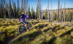
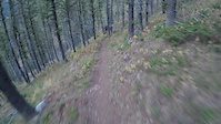
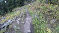
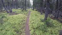
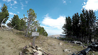
Photos of West Yellowstone Mountain Bike
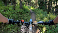
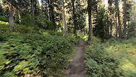
Videos of West Yellowstone Mountain Bike
trail: Two Top Divide
0:04 |
153 |
Sep 25, 2019
trail: Two Top Divide
0:03 |
103 |
Sep 25, 2019
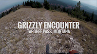
trail: CDT Targhee Pass
0:35 |
838 |
Oct 7, 2018
trail: CDT Targhee Pass
7:30 |
267 |
Oct 3, 2018
trail: Sheep Lake
6:16 |
207 |
Oct 3, 2018
trail: Sheep Lake
6:10 |
216 |
Oct 3, 2018
trail: CDT Targhee Pass
6:12 |
112 |
Oct 2, 2018
trail: CDT Targhee Pass
5:13 |
109 |
Oct 2, 2018
Recent Trail Reports
| status | trail | date | condition | info | user |
|---|---|---|---|---|---|
| Targhee Creek | Jun 24, 2026 @ 7:08pm (America/Denver) 22 hours | Ideal | HillsboroMTB | ||
| Purple Haze | Jan 9, 2026 @ 4:35pm (America/Boise) Jan 9, 2026 | Ideal | markegge | ||
| Volunteer | Jan 9, 2026 @ 4:35pm (America/Boise) Jan 9, 2026 | Ideal | markegge | ||
| In & Out | Jan 9, 2026 @ 4:35pm (America/Boise) Jan 9, 2026 | Ideal | markegge | ||
| Sheep Lake | Oct 22, 2025 @ 4:00pm (America/Denver) Oct 22, 2025 | Snow Covered | Echo219 | ||
| West Fork Watkins Creek | Sep 24, 2025 @ 7:04pm (America/Denver) Sep 24, 2025 | Dry | elsquatcho | ||
| Watkins Creek | Sep 24, 2025 @ 7:03pm (America/Denver) Sep 24, 2025 | Ideal | elsquatcho | ||
| Mile Creek (CDT) | Sep 24, 2025 @ 6:59pm (America/Denver) Sep 24, 2025 | Ideal | elsquatcho | ||
| Dead Dog | Sep 4, 2025 @ 6:05pm Sep 4, 2025 | Ideal | Jxroussel | ||
| Raynolds Pass Connect | Aug 11, 2025 @ 10:53am Aug 11, 2025 | Dry | markegge |
National Scenic Trails & Official Routes
-
Continental Divide Trail
- Mountain Bike
- Hike
- Trail Running
-
Great Western Trail
- Mountain Bike
- E-Bike
- Horse
- Hike
- Trail Running
- Dirtbike/Moto
- ATV/ORV/OHV


Activity Feed
| username | action | type | title | date |
|---|---|---|---|---|
| DinsmoreBailey | comment | report | activity #97768682 | Jun 25, 2026 @ 7:57am 8 hours |
| HillsboroMTB | add | report | activity #97738325 | Jun 24, 2026 @ 6:09pm 22 hours |
| Dolomite33 | wishlist | trail | activity #97619847 and 2 more | Jun 23, 2026 @ 5:36am 2 days |
| FSqTOn | wishlist | trail | activity #97533610 | Jun 21, 2026 @ 5:31pm Jun 21, 2026 |
| mtnbiker62 | wishlist | trail | activity #97013480 | Jun 14, 2026 @ 4:51pm Jun 14, 2026 |
Recent Comments
| username | type | title | comment | date |
|---|---|---|---|---|
| report | Did you get to top where connects to CDT?... | Jun 25, 2026 @ 7:57am 8 hours | ||
| trail | I don’t think this trail is very good,... | May 8, 2026 @ 6:54pm May 8, 2026 | ||
| trail | This is a great trail system if you ever... | Nov 14, 2025 @ 10:40pm Nov 14, 2025 | ||
| trail | I like it | Nov 14, 2025 @ 10:40pm Nov 14, 2025 | ||
| trail | Nice route | Nov 14, 2025 @ 10:39pm Nov 14, 2025 |
Local Badges
-

10 Blue Trails10 awarded -

Epic Ride Climb 2k42 awarded -

Climbing 10k Badge11 awarded -

Climbing 100k Badge0 awarded -

Epic Ride Descent 2k44 awarded -

Descent 10k Badge11 awarded
Activity Type Stats
| activitytype | trails | distance | descent | descent distance | total vertical | rating | global rank | state rank | photos | reports | routes | ridelogs |
|---|---|---|---|---|---|---|---|---|---|---|---|---|
| Mountain Bike | 67 | 195 miles | 18,527 ft | 64 miles | 4,695 ft | #1,447 | #547 | 314 | 270 | 7 | 3,205 | |
| E-Bike | 13 | 76 miles | 4,928 ft | 18 miles | 3,780 ft | #2,586 | #1,032 | 6 | 132 | 144 | ||
| Winter Fat Bike | 5 | #373 | #1,126 | 1 | 3 | |||||||
| Horse | 31 | 97 miles | 7,782 ft | 27 miles | 4,026 ft | #725 | #554 | 101 | 2 | |||
| Hike | 70 | 184 miles | 16,765 ft | 57 miles | 4,695 ft | #458 | #213 | 26 | 271 | 1 | 630 | |
| Trail Running | 69 | 184 miles | 16,690 ft | 57 miles | 4,695 ft | #1,002 | #372 | 271 | 1 | 178 | ||
| Dirtbike/Moto | 11 | 70 miles | 2,917 ft | 14 miles | 3,743 ft | #156 | #95 | 70 | 21 | |||
| ATV/ORV/OHV | 8 | 65 miles | 2,890 ft | 13 miles | 3,330 ft | #450 | #149 | 68 | 8 | |||
| Snowmobile | 4 | 56 miles | 2,077 ft | 11 miles | 2,890 ft | #65 | #41 | 46 | 29 | |||
| Snowshoe | 17 | 27 miles | 1,434 ft | 11 miles | 630 ft | #773 | #348 | 44 | 38 | |||
| Backcountry Ski | 6 | 5 miles | 367 ft | 2 miles | 371 ft | #597 | #200 | 40 | 228 | |||
| Nordic Ski | 16 | 23 miles | 1,089 ft | 9 miles | 518 ft | #202 | #54 | 46 | 1,827 |
Frequently Asked Questions About West Yellowstone
▼
What are the best places to ride in West Yellowstone?
West Yellowstone has 4 areas to explore for mountain biking. The top rated areas are:
▼
What are the highest rated mountain biking trails in West Yellowstone?
The highest rated mountain biking trails in West Yellowstone are:
- CDT Targhee Pass (4.6/5)
- Mile Creek (CDT) (4.4/5)
- Sheep Lake (4.4/5)
- Coffin Lakes (4.2/5)
- Mile Creek Face (4.2/5)
▼
What is the best time of the year to ride in West Yellowstone?
Based on ride log data, the most popular months to ride in West Yellowstone are:
- July (105 activities)
- August (79 activities)
- June (42 activities)
▼
Where can I park to ride in West Yellowstone?
There are 11 parking locations listed in West Yellowstone. The most popular parking spots are: View all parking and trailhead locations on the map to plan your visit.
Activities
- West Yellowstone Mountain Biking Trails
- West Yellowstone E-Biking Trails
- West Yellowstone Winter Fat Biking Trails
- West Yellowstone Horseback Trails
- West Yellowstone Hiking Trails
- West Yellowstone Trail Running Trails
- West Yellowstone Dirtbiking Trails
- West Yellowstone ATVing/Offroading Trails
- West Yellowstone Snowshoeing Trails
- West Yellowstone Backcountry Skiing Trails
- West Yellowstone Nordic Skiing Trails
Trails
- By evasive
 MBG & contributors
 - Admins: SWMMBA, HCC
- #15434 - 10,293 views
- west yellowstone activity log | embed map of West Yellowstone mountain bike trails | west yellowstone mountain biking points of interest
Downloading of trail gps tracks in kml & gpx formats is enabled for West Yellowstone.
You must login to download files.