close
-
Layers w
- Weather Layers
- Pro
- Pro
- Pro
- Pro
- Pro
- Pro
- More Layers
- Pro
- Pro
- Pro
- Pro
-
Upgrade to

3D
Trail Conditions
- Unknown
- Snow Groomed
- Snow Packed
- Snow Covered
- Snow Cover Partial
- Freeze/thaw Cycle
- Icy
- Prevalent Mud
- Wet
- Variable
- Ideal
- Dry
- Very Dry
Trail Flow (Ridden Direction)
Trailforks scans users ridelogs to determine the most popular direction each trail is ridden. A good flowing trail network will have most trails flowing in a single direction according to their intension.
The colour categories are based on what percentage of riders are riding a trail in its intended direction.
The colour categories are based on what percentage of riders are riding a trail in its intended direction.
- > 96%
- > 90%
- > 80%
- > 70%
- > 50%
- < 50%
- bi-directional trail
- no data
Trail Last Ridden
Trailforks scans ridelogs to determine the last time a trail was ridden.
- < 2 days
- < 1 week
- < 2 weeks
- < 1 month
- < 6 months
- > 6 months
Trail Ridden Direction
The intended direction a trail should be ridden.
- Downhill Only
- Downhill Primary
- Both Directions
- Uphill Primary
- Uphill Only
- One Direction
Contribute Details
Colors indicate trail is missing specified detail.
- Description
- Photos
- Description & Photos
- Videos
Trail Popularity ?
Trailforks scans ridelogs to determine which trails are ridden the most in the last 9 months.
Trails are compared with nearby trails in the same city region with a possible 25 colour shades.
Think of this as a heatmap, more rides = more kinetic energy = warmer colors.
- most popular
- popular
- less popular
- not popular
ATV/ORV/OHV Filter
Max Vehicle Width
inches
US Cell Coverage
Legend

Radar Time
Activity Recordings
Trailforks uses anonymized public activity data.
?
Activity Recordings
Trailforks uses anonymized public activity data.
?
Personal Heatmap
▶
Activity Types
all
/
none
▶
Options
2
Date range
month
–
Winter Trails
Warning
A routing network for winter maps does not exist. Selecting trails using the winter trails layer has been disabled.
Missing Trails
Most Popular
Least Popular
Trails are colored based on popularity. The more popular a trail is, the more red. Less popular trails trend towards green.
Jump Magnitude Heatmap
Heatmap of where riders jump on trails. Zoom in to see individual jumps, click circles to view jump details.
BC Backroad Status
![map legend]()
Service Road Atlas is a free to use, community-driven service for viewing and creating reports on the numerous back-country service roads around B.C. and Alberta.

Slope Aspect
Direction the slope faces
Trails Deemphasized
Trails are shown in grey.
Only show trails with no bike usage.
Suggested Layers
Based on selected activity type
Save the current map location and zoom level as your default home location whenever this page is loaded.
SaveWelcome to the Westsyde Trail Network.
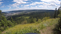
This is an intermediate to advanced area which has 40 trails including the legendary Box Trail loop which is a XC epic with view of the Fraser River and covers over 25Km.
This network is also host to some of Williams Lake most progressive free-riding, such as Snakes & Ladders which incorporates 22,000 feet of Cariboo Lumber. If you are looking to get rowdy check out the more advanced trails located off the Repeater Tower.
Most trails are accessed from the Snakes & Ladders parking lot located on Bysak Road.
Please note that access to the River Valley is currently closed due to landslides in 2020.
Have fun, support the Williams Lake Cycling Club and watch out for brown features
Help support our trail network, purchase your Williams Lake Cycling Club membership a href="https://spruceregistrations.com/wlcc/register/">here/a>
source: ridethecariboo.ca
Primary Trail Type: All-Mountain & Downhill
Shuttleable: YES
 google parking directions
 Region Supporters & Maintainers
![]()
Ride The CaribooMaintainer
Activities Click to view
- Mountain Bike
64 trails
- E-Bike
7 trails
- Hike
61 trails
- Trail Running
61 trails
Region Details
- 13
- 12
- 25
- 13
- 1
Region Status
Caution as of 14 hoursStats
- Avg Trail Rating
- Trails (view details)
- 64
- Trails Mountain Bike
- 64
- Trails E-Bike
- 7
- Trails Gravel Bike
- 3
- Trails Hike
- 61
- Trails Trail Running
- 61
- Total Distance
- 89 miles
- Total Descent
- 22,276 ft
- Total Vertical
- 1,983 ft
- Highest Trailhead
- 3,323 ft
- Reports
- 825
- Photos
- 511
- Ridden Counter
- 4,043
Popular Westsyde Mountain Biking Trails
• 90 ★ 2.6 • 1 mile • 650 ft • 285 •
Original line on Westsyde, ridable both ways. Sweet trail winding along a drainage with some nice features en route. Climb up to the Repeater Tower via or heading down from the upper zone, this is a sweet core connector to all Westsyde.
• 70 ★ 3.5 • 4 miles • 69 ft • 250 •
and Ladders was completely re-built in 2012. It incorporates over 22,000 board feet of Cariboo lumber in sky berms, tables, step downs, and other features with the tightest and fastest single track around.
• 85 ★ 3.5 • 1,083 ft • 3 ft • 230 •
Phil received a rebuild in late 2021! This trail now contains the longest TTF in the Cariboo! Constructed by New Path Forestry, the new TTF built is 600 ft long and is replacing one of William Lake's older, longer and more TTF that was...
• 90 ★ 3.4 • 3,182 ft • 182 ft • 219 •
Right across from the exit, follow the fence line to the drop in of the new . 4 tight turns and you're into the original . Drops you into the River Valley for a climb out to the Cematery parking lot..
Hung extension Permanently Closed
• 85 ★ 2.0 • 622 ft • 8 ft • 182 •
As you descend 'deer trail' or the trail divides with the upper line an extension of ' ' which although primarily a flowy sidehill dh, it remains climbable. The lower line is original 'deer trail' that gets little use.
• 85 ★ 0.0 • 1 mile • 93 ft • 140 •
This is the primary exit and entrance to the Westsyde trail network for 2020. The bridge to is damaged and closed as is the rest of the River Valley. This rolling route starts at the /Max/Boogawooga trail heads. Head East on the gravel...
• 85 ★ 3.5 • 2,838 ft • 3 ft • 131 •
Hit from Birch Lane for a freeride experience. Go down to Browny Wings, or keep er' pinned all the way to . This is a great climb to access the deep westsyde experience.
• 80 ★ 0.0 • 1,050 ft • 87 ft • 124 •
Beginner singletrack trail. All natural, no TTF’s. Take this trail if you’ve just finished a downhill and you’d rather ride some singaltrack than the road to finish off your ride. The River Valley is a popular place for hikers so...
Westsyde Mountain Bike Routes
★ 4.0 • 12 miles • 2,464 ft • 17 •
A long and tough climb up to and back via Boogaloos Wooga. Makes for a long XC ride with plenty of fun...
10 miles • 828 ft • 7 • Shuttled •
Start in Westsyde network and finish at the bottom of South Side. Shuttle ride with bits of climbs throughout.
30 miles • 5,403 ft • 25 • Point to Point • Race •
FULL FACE MANDATORY FOR ALL U21 ATHLETES **MEET AT THE TOURISM CENTER FOR REGISTRATION** Departure Time,...
• 9 miles • 1,752 ft • 8 •
• 14 miles • 1,162 ft • 1 •
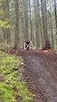
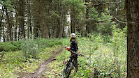
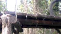
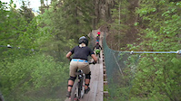
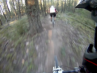
Photos of Westsyde Mountain Bike
Videos of Westsyde Mountain Bike

trail: Brownie Wings
0:05 |
23 |
Oct 7, 2024
trail: Cherry Popper
0:06 |
37 |
Oct 7, 2024
trail: Phil's Deli
0:08 |
386 |
Jul 30, 2019

3:22 |
16637 |
Dec 16, 2018
trail: Dead Sailor
4:13 |
415 |
Feb 18, 2017
trail: Back Door XC
0:29 |
529 |
Jun 4, 2016
trail: Snakes & Ladders
3:27 |
41366 |
May 22, 2013
trail: Snakes
3:52 |
648 |
Feb 7, 2013
Current Trail Warnings
| status | trail | date | condition | user | info |
|---|---|---|---|---|---|
| Dog Gone | May 23, 2026 @ 10:47am (America/Vancouver) May 23, 2026 | Unknown | Hutchbiker WLCC | Tree down on dog gone |
Recent Trail Reports
| status | trail | date | condition | info | user |
|---|---|---|---|---|---|
| Cherry Popper | Jun 21, 2026 @ 9:30am (America/Vancouver) 14 hours | Dry | charlesn50 | ||
| Spokey Hollow | Jun 21, 2026 @ 9:30am (America/Vancouver) 14 hours | Unknown | charlesn50 | ||
| Booga Wooga | Jun 18, 2026 @ 12:50pm (America/Vancouver) Jun 18, 2026 | Dry | kimlew | ||
| Lower Max | Jun 18, 2026 @ 12:49pm (America/Vancouver) Jun 18, 2026 | Dry | kimlew | ||
| Deertrails | Jun 12, 2026 @ 8:35am (America/Vancouver) Jun 12, 2026 | Ideal | fulty WLCC | ||
| Phil's Deli | Jun 10, 2026 @ 6:23pm (America/Vancouver) Jun 10, 2026 | Ideal | fulty WLCC | ||
| Back Door XC | Jun 3, 2026 @ 6:20pm (America/Vancouver) Jun 3, 2026 | Dry | fulty WLCC | ||
| Esler Low Mobilty Trail | May 26, 2026 @ 9:33pm (America/Vancouver) May 26, 2026 | Ideal | JordanLJAzWv | ||
| Crankcase | May 25, 2026 @ 12:22pm (America/Los_Angeles) May 25, 2026 | Ideal | Chickenlewy WLCC | ||
| Alt Snakes and Ladders | May 21, 2026 @ 1:47pm (America/Vancouver) May 21, 2026 | Unknown | theblackflash |
Activity Feed
| username | action | type | title | date |
|---|---|---|---|---|
| charlesn50 | add | report | activity #97541470 and 1 more | Jun 21, 2026 @ 9:04pm 2 hours |
| kimlew | add | report | activity #97271005 and 1 more | Jun 18, 2026 @ 12:49pm Jun 18, 2026 |
| fulty | add | report | activity #96806709 and 1 more | Jun 12, 2026 @ 8:34am Jun 12, 2026 |
| fulty | add | report | activity #96234014 | Jun 4, 2026 @ 9:33am Jun 4, 2026 |
| TrevorSowersXc2 | wishlist | trail | activity #96226087 | Jun 4, 2026 @ 7:30am Jun 4, 2026 |
Recent Comments
| username | type | title | comment | date |
|---|---|---|---|---|
| report | .. | May 20, 2026 @ 7:45pm May 20, 2026 | ||
| report | Good to go | May 2, 2026 @ 3:26pm May 2, 2026 | ||
| report | Tree/ branches have been cleared | Apr 17, 2026 @ 4:16pm Apr 17, 2026 | ||
| report | And cleared dead sailor intersection | Apr 17, 2026 @ 4:06pm Apr 17, 2026 | ||
| report | Tree is removed (the one right by bush invader... | Apr 17, 2026 @ 3:33pm Apr 17, 2026 |
Nearby Areas
| name | distance | ||||
|---|---|---|---|---|---|
| Fox Mountain | 13 | 26 | 15 | 3 | 4.9 km |
| South Side | 1 | 28 | 8 | 5.4 km | |
| Chief Will Yum | 1 | 2 | 1 | 8.8 km | |
| Desous | 3 | 5 | 11 | 1 | 10.5 km |
| Xat'sull - Soda Creek | 1 | 6 | 1 | 14.6 km |
Local Badges
-

Completionist0 awarded
Local Mountain Biking Directory
-
Williams Lake Cycling Club
![Williams Lake Cycling Club]()
-
Fox Mountain Brewing Co.
-
Ride The CaribooTrail Association
![Ride The Cariboo]()
-
Red Shreds Bike & Board shedBike Shop
![Red Shreds Bike & Board shed]()
Local Trail Supporters
![]()
- Chris Master
Activity Type Stats
| activitytype | trails | distance | descent | descent distance | total vertical | rating | global rank | state rank | photos | reports | routes | ridelogs |
|---|---|---|---|---|---|---|---|---|---|---|---|---|
| Mountain Bike | 64 | 89 miles | 22,277 ft | 46 miles | 1,982 ft | #1,942 | #123 | 489 | 825 | 4 | 2,329 | |
| E-Bike | 7 | 1 mile | 151 ft | 4,177 ft | 131 ft | #8,354 | #308 | 4 | 526 | 69 | ||
| Gravel Bike | 3 | #1,765 | #142 | 27 | ||||||||
| Hike | 61 | 87 miles | 21,165 ft | 45 miles | 1,982 ft | #2,730 | #117 | 3 | 817 | 1 | 209 | |
| Trail Running | 61 | 87 miles | 21,165 ft | 45 miles | 1,982 ft | #171 | #13 | 14 | 817 | 2 | 118 |
Frequently Asked Questions About Westsyde
▼
What are the highest rated mountain biking trails in Westsyde?
The highest rated mountain biking trails in Westsyde are:
- Back Door XC (4.3/5)
- Brownie Wings (4.1/5)
- Dead Sailor (4.1/5)
- Sweet Pete (4.1/5)
- Outer Max (4/5)
▼
What is the best time of the year to ride in Westsyde?
Based on ride log data, the most popular months to ride in Westsyde are:
- July (92 activities)
- June (74 activities)
- May (62 activities)
▼
Where can I park to ride in Westsyde?
There are 1 parking locations listed in Westsyde. The most popular parking spots are:
▼
What is the longest trail in Westsyde?
The longest trail in Westsyde is Ye Old Box at 6.8 miles. View all trails sorted by distance.
Activities
Trails
- By brenthillier
 NSMBA TRAILFORKS & contributors
 - Admins: CMBC, WLCC, RSTBC
- #3331 - 12,649 views
- westsyde activity log | embed map of Westsyde mountain bike trails | westsyde mountain biking points of interest
Downloading of trail gps tracks in kml & gpx formats is enabled for Westsyde.
You must login to download files.