close
-
Layers w
- Weather Layers
- Pro
- Pro
- Pro
- Pro
- Pro
- Pro
- More Layers
- Pro
- Pro
- Pro
- Pro
-
Upgrade to

3D
Trail Conditions
- Unknown
- Snow Groomed
- Snow Packed
- Snow Covered
- Snow Cover Partial
- Freeze/thaw Cycle
- Icy
- Prevalent Mud
- Wet
- Variable
- Ideal
- Dry
- Very Dry
Trail Flow (Ridden Direction)
Trailforks scans users ridelogs to determine the most popular direction each trail is ridden. A good flowing trail network will have most trails flowing in a single direction according to their intension.
The colour categories are based on what percentage of riders are riding a trail in its intended direction.
The colour categories are based on what percentage of riders are riding a trail in its intended direction.
- > 96%
- > 90%
- > 80%
- > 70%
- > 50%
- < 50%
- bi-directional trail
- no data
Trail Last Ridden
Trailforks scans ridelogs to determine the last time a trail was ridden.
- < 2 days
- < 1 week
- < 2 weeks
- < 1 month
- < 6 months
- > 6 months
Trail Ridden Direction
The intended direction a trail should be ridden.
- Downhill Only
- Downhill Primary
- Both Directions
- Uphill Primary
- Uphill Only
- One Direction
Contribute Details
Colors indicate trail is missing specified detail.
- Description
- Photos
- Description & Photos
- Videos
Trail Popularity ?
Trailforks scans ridelogs to determine which trails are ridden the most in the last 9 months.
Trails are compared with nearby trails in the same city region with a possible 25 colour shades.
Think of this as a heatmap, more rides = more kinetic energy = warmer colors.
- most popular
- popular
- less popular
- not popular
ATV/ORV/OHV Filter
Max Vehicle Width
inches
US Cell Coverage
Legend

Radar Time
Activity Recordings
Trailforks uses anonymized public activity data.
?
Activity Recordings
Trailforks uses anonymized public activity data.
?
Personal Heatmap
▶
Activity Types
all
/
none
▶
Options
2
Date range
month
–
Winter Trails
Warning
A routing network for winter maps does not exist. Selecting trails using the winter trails layer has been disabled.
Missing Trails
Most Popular
Least Popular
Trails are colored based on popularity. The more popular a trail is, the more red. Less popular trails trend towards green.
Jump Magnitude Heatmap
Heatmap of where riders jump on trails. Zoom in to see individual jumps, click circles to view jump details.
BC Backroad Status
![map legend]()
Service Road Atlas is a free to use, community-driven service for viewing and creating reports on the numerous back-country service roads around B.C. and Alberta.

Slope Aspect
Direction the slope faces
Trails Deemphasized
Trails are shown in grey.
Only show trails with no bike usage.
Suggested Layers
Based on selected activity type
Save the current map location and zoom level as your default home location whenever this page is loaded.
Save
No description for White Cloud has been added yet!
Login or register to submit one.
Region Supporters & Maintainers
![]()
Central District CyclerySponsor![]()
Grand Rapids Bicycle CompanySponsor![]()
Perrin Brewing CompanySponsor![Merrell]()
MerrellSponsor![Wynalda Packaging]()
Wynalda PackagingSponsor
Activities Click to view
- Mountain Bike
30 trails
- E-Bike
7 trails
- Adaptive Bike
- Winter Fat Bike
0 trails
- Horse
37 trails
- Hike
79 trails
- Trail Running
53 trails
- Dirtbike/Moto
2 trails
- ATV/ORV/OHV
0 trails
- Snowmobile
0 trails
- Snowshoe
20 trails
- Downhill Ski
0 trails
- Backcountry Ski
11 trails
- Nordic Ski
10 trails
Region Details
- 8
- 13
- 5
Region Status
Open as of Jun 15, 2026Stats
- Avg Trail Rating
- Trails (view details)
- 64
- Trails Mountain Bike
- 31
- Trails E-Bike
- 7
- Trails Horse
- 37
- Trails Hike
- 79
- Trails Trail Running
- 53
- Trails Dirtbike/Moto
- 2
- Trails Snowshoe
- 20
- Trails Backcountry Ski
- 11
- Trails Nordic Ski
- 10
- Total Distance
- 148 miles
- Total Descent
- 9,428 ft
- Total Vertical
- 605 ft
- Highest Trailhead
- 1,295 ft
- Reports
- 359
- Photos
- 148
- Ridden Counter
- 7,324
Sub Regions
-
Hungerford Lake
- 1
-
Huron/Manistee Forest (Newaygo County)
- 1
- 2
-
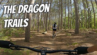
The Dragon Trails
- 12
- 1
Popular White Cloud Mountain Biking Trails
• 95 ★ 5.0 • 6 miles • 604 ft • 886 •
Very flowy with very little technical sections. Any technical sections or jumps are easy to ride around.
• 95 ★ 4.7 • 2 miles • 26 ft • 788 •
Segment 8 isn't complete yet, but this much is open to ride. Park at the north end
• 75 ★ 4.7 • 2 miles • 85 ft • 765 •
One of the first Dragon Trail segments completed. When this entire trail is completed it will be approximately a 47 mile loop. This section is very flat with one log ride over and one bridge. Very scenic.
• 100 ★ 5.0 • 5 miles • 285 ft • 655 •
Beautiful section, less climbing than the west side of the pond but a great ride with more elevation than section 5. One bridge still needs to be installed but you can easily cross the shallow stream on foot as of 10-2-22
• 90 ★ 3.5 • 4 miles • 223 ft • 567 •
Segment 4 is another beautiful section with a little more climbing than Segment 5. You can park at Brower Park and pay the parking fee or park at the Newago State Park boat ramp parking area for free as long as you have the Michigan...
• 85 ★ 4.0 • 6 miles • 290 ft • 555 •
Segment 5- Blue. This section is rated easy, very little climbing, perfect for young ones and as a bonus you can ride the completed 1.7 mile Brower Loop also. The forest is very diversified and scenic, and the real highlight of this...
• 100 ★ 5.0 • 2 miles • 30 ft • 505 •
Popular green difficulty singletrack. This multi-use trail can be used both directions. On average it takes 11 minutes to complete this trail.
• 75 ★ 5.0 • 8 miles • 577 ft • 450 •
Popular green difficulty singletrack. This multi-use trail can be used both directions. On average it takes 7 minutes to complete this trail.
White Cloud Mountain Bike Routes
43 miles • 2,101 ft • 9 • Loop •
Photos of White Cloud Mountain Bike
Videos of White Cloud Mountain Bike

trail: Dragon Trail - Section 7
14:55 |
181 |
Oct 11, 2024 , White Cloud
youtuber
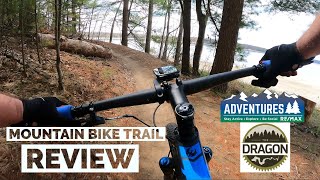
![The Dragon Trails at Newaygo State Park, MI]()
15:43 |
425 |
Jun 30, 2022

8:01 |
418 |
Feb 22, 2022 , White Cloud

trail: Dragon Trail - Section 7
8:01 |
249 |
Feb 22, 2022 , White Cloud

22:14 |
755 |
Apr 20, 2021 , White Cloud
22:14 |
478 |
Apr 20, 2021 , White Cloud
youtuber
![The Dragon Mountain Bike Trail - Groomed Fat...]()

32:03 |
723 |
Jan 28, 2021 , White Cloud
youtuber
![Old School XC Singletrack - The North Country...]()
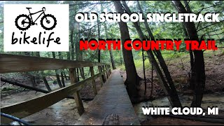
trail: NCT - M20 to W 11 Mile Rd
12:39 |
475 |
Oct 1, 2020 , White Cloud
Recent Trail Reports
| status | trail | date | condition | info | user |
|---|---|---|---|---|---|
| Dragon Trail - Segment 8 (Red) | Jun 15, 2026 @ 12:35pm (America/Menominee) Jun 15, 2026 | Variable | Roadwarriorxo | ||
| Dragon Trail - Segment 9 (Lime) | Jun 15, 2026 @ 12:35pm (America/Menominee) Jun 15, 2026 | Ideal | Roadwarriorxo | ||
| Dragon Trail Segment 2 | Jun 15, 2026 @ 12:35pm (America/Menominee) Jun 15, 2026 | Ideal | Roadwarriorxo | ||
| Dragon Trail - Segment 3 (Tan) | May 24, 2026 @ 3:45pm (America/Menominee) May 24, 2026 | Ideal | aarontriton | ||
| Hungerford Lake North Loop | Apr 25, 2026 @ 2:28pm (America/Detroit) Apr 25, 2026 | Unknown | truebleve Trailforks | ||
| Dragon Trail - Segment 10 (Orange) | Feb 5, 2026 @ 11:24am (America/Menominee) Feb 5, 2026 | Variable | Trekex | ||
| Dragon Trail Segment 1 | Feb 5, 2026 @ 11:24am (America/Menominee) Feb 5, 2026 | Ideal | Trekex | ||
| The Brower Loop | Feb 5, 2026 @ 11:24am (America/Menominee) Feb 5, 2026 | Variable | Trekex | ||
| Hungerford Lake South Loop | Jan 10, 2026 @ 10:53pm (America/Detroit) Jan 10, 2026 | Unknown | Wildmanhah | ||
| FS 5955 | Oct 4, 2025 @ 11:29am (America/Detroit) Oct 4, 2025 | Dry | bhren |
Activity Feed
| username | action | type | title | date |
|---|---|---|---|---|
| Somertime | ridden | trail | activity #97403504 | Jun 20, 2026 @ 9:17am 1 day |
| Roadwarriorxo | add | report | activity #97073125 and 2 more | Jun 15, 2026 @ 4:33pm Jun 15, 2026 |
| campkarl | wishlist | region | activity #96559812 | Jun 8, 2026 @ 1:05pm Jun 8, 2026 |
| campkarl | wishlist | route | activity #96559507 | Jun 8, 2026 @ 1:01pm Jun 8, 2026 |
| swernette | wishlist | region | activity #96372868 | Jun 6, 2026 @ 8:17am Jun 6, 2026 |
Recent Comments
| username | type | title | comment | date |
|---|---|---|---|---|
| report | Tree removed from the trail | Oct 27, 2025 @ 12:17pm Oct 27, 2025 | ||
| report | All clear | Jun 26, 2025 @ 6:22am Jun 26, 2025 | ||
| report | Cleared | May 29, 2025 @ 6:40am May 29, 2025 | ||
| trail | With all of the armoring, this segment should... | Oct 26, 2024 @ 7:18am Oct 26, 2024 | ||
| trail | Park at Operators Village Park Dam kinda... | Sep 5, 2024 @ 12:59pm Sep 5, 2024 |
Local Badges
-

Completionist0 awarded -

10 Green Trails198 awarded -

Epic Mountain Bike Climb 2k2 awarded -

Climbing 10k Badge12 awarded -

Mountain Biking 100k Badge0 awarded -

Epic Ride Descent 2k2 awarded
Local Trail Supporters
- Spectrum Trail Design
Activity Type Stats
| activitytype | trails | distance | descent | descent distance | total vertical | rating | global rank | state rank | photos | reports | routes | ridelogs |
|---|---|---|---|---|---|---|---|---|---|---|---|---|
| Mountain Bike | 30 | 67 miles | 4,370 ft | 23 miles | 564 ft | #2,680 | #957 | 128 | 359 | 1 | 4,340 | |
| E-Bike | 7 | 3,727 ft | 30 ft | 1,535 ft | 151 ft | #10,205 | #3,218 | 5 | 326 | 1 | 35 | |
| Horse | 37 | 42 miles | 4,029 ft | 17 miles | 308 ft | #112 | #377 | 16 | 14 | 187 | ||
| Hike | 79 | 148 miles | 9,429 ft | 51 miles | 604 ft | #1,804 | #784 | 359 | 144 | |||
| Trail Running | 53 | 109 miles | 5,640 ft | 35 miles | 574 ft | #2,481 | #738 | 359 | 30 | |||
| Dirtbike/Moto | 2 | 2 miles | 33 ft | 4,560 ft | 39 ft | #1,343 | #558 | 9 | 1 | |||
| Snowshoe | 20 | 58 miles | 2,280 ft | 16 miles | 236 ft | #548 | #203 | 12 | 1 | |||
| Backcountry Ski | 11 | 19 miles | 738 ft | 5 miles | 102 ft | #568 | #174 | 11 | 1 | |||
| Nordic Ski | 10 | 34 miles | 1,447 ft | 9 miles | 236 ft | #909 | #370 | 8 | 3 |
Frequently Asked Questions About White Cloud
▼
What are the best places to ride in White Cloud?
White Cloud has 4 areas to explore for mountain biking. The top rated areas are:
▼
What are the highest rated mountain biking trails in White Cloud?
The highest rated mountain biking trails in White Cloud are:
- NCT - M20 to W 11 Mile Rd (4.4/5)
- Dragon Trail - Segment 9 (Lime) (4.4/5)
- Dragon Trail - Segment 10 (Orange) (4.2/5)
- Dragon Trail - Segment 8 (Red) (4.2/5)
- Dragon Trail - Segment 3 (Tan) (4.1/5)
▼
What is the best time of the year to ride in White Cloud?
Based on ride log data, the most popular months to ride in White Cloud are:
- August (19 activities)
- July (19 activities)
- October (15 activities)
▼
Where can I park to ride in White Cloud?
There are 12 parking locations listed in White Cloud. The most popular parking spots are: View all parking and trailhead locations on the map to plan your visit.
Activities
Trails
Points of Interest
- Hungerford Equestrian Campground Camping
- Hungerford Equestrian Campground Camping
- Hungerford Equestrian Group Campground Camping
- Highbank Lake Campground Camping
- Condon Lake West Campground Camping
- Walkup Lake Campground Camping
- Nichols Lake campground Camping
- Benton Lake Campground Camping
- Indian Lake Campground Camping
- White Cloud Campground Camping
- By WillieJacobsz
 Trailforks SBP SWW & contributors
 - Admins: apply
- #49865 - 1,770 views
- white cloud activity log | embed map of White Cloud mountain bike trails | white cloud mountain biking points of interest
Downloading of trail gps tracks in kml & gpx formats is enabled for White Cloud.
You must login to download files.