close
-
Layers w
- Weather Layers
- Pro
- Pro
- Pro
- Pro
- Pro
- Pro
- More Layers
- Pro
- Pro
- Pro
- Pro
-
Upgrade to

3D
Trail Conditions
- Unknown
- Snow Groomed
- Snow Packed
- Snow Covered
- Snow Cover Partial
- Freeze/thaw Cycle
- Icy
- Prevalent Mud
- Wet
- Variable
- Ideal
- Dry
- Very Dry
Trail Flow (Ridden Direction)
Trailforks scans users ridelogs to determine the most popular direction each trail is ridden. A good flowing trail network will have most trails flowing in a single direction according to their intension.
The colour categories are based on what percentage of riders are riding a trail in its intended direction.
The colour categories are based on what percentage of riders are riding a trail in its intended direction.
- > 96%
- > 90%
- > 80%
- > 70%
- > 50%
- < 50%
- bi-directional trail
- no data
Trail Last Ridden
Trailforks scans ridelogs to determine the last time a trail was ridden.
- < 2 days
- < 1 week
- < 2 weeks
- < 1 month
- < 6 months
- > 6 months
Trail Ridden Direction
The intended direction a trail should be ridden.
- Downhill Only
- Downhill Primary
- Both Directions
- Uphill Primary
- Uphill Only
- One Direction
Contribute Details
Colors indicate trail is missing specified detail.
- Description
- Photos
- Description & Photos
- Videos
Trail Popularity ?
Trailforks scans ridelogs to determine which trails are ridden the most in the last 9 months.
Trails are compared with nearby trails in the same city region with a possible 25 colour shades.
Think of this as a heatmap, more rides = more kinetic energy = warmer colors.
- most popular
- popular
- less popular
- not popular
ATV/ORV/OHV Filter
Max Vehicle Width
inches
US Cell Coverage
Legend

Radar Time
Activity Recordings
Trailforks uses anonymized public activity data.
?
Activity Recordings
Trailforks uses anonymized public activity data.
?
Personal Heatmap
▶
Activity Types
all
/
none
▶
Options
2
Date range
month
–
Winter Trails
Warning
A routing network for winter maps does not exist. Selecting trails using the winter trails layer has been disabled.
Missing Trails
Most Popular
Least Popular
Trails are colored based on popularity. The more popular a trail is, the more red. Less popular trails trend towards green.
Jump Magnitude Heatmap
Heatmap of where riders jump on trails. Zoom in to see individual jumps, click circles to view jump details.
BC Backroad Status
![map legend]()
Service Road Atlas is a free to use, community-driven service for viewing and creating reports on the numerous back-country service roads around B.C. and Alberta.

Slope Aspect
Direction the slope faces
Trails Deemphasized
Trails are shown in grey.
Only show trails with no bike usage.
Suggested Layers
Based on selected activity type
Save the current map location and zoom level as your default home location whenever this page is loaded.
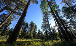
Save2.76-million-acre forest of the White Mountains and North of the Mogollon Rim in Northern Arizona.
Primary Trail Type: Cross-Country
Land Status: National Forest
Activities Click to view
- Mountain Bike
265 trails
- E-Bike
66 trails
- Horse
161 trails
- Hike
229 trails
- Trail Running
226 trails
- Dirtbike/Moto
14 trails
- ATV/ORV/OHV
11 trails
- Snowshoe
1 trails
- Downhill Ski
49 trails
- Backcountry Ski
0 trails
- Nordic Ski
28 trails
Stats
- Avg Trail Rating
- Trails (view details)
- 293
- Trails Mountain Bike
- 265
- Trails E-Bike
- 66
- Trails Gravel Bike
- 14
- Trails Winter Fat Bike
- 9
- Trails Horse
- 161
- Trails Hike
- 229
- Trails Trail Running
- 226
- Trails Dirtbike/Moto
- 14
- Trails ATV/ORV/OHV
- 11
- Trails Snowmobile
- 1
- Trails Snowshoe
- 1
- Trails Downhill Ski
- 49
- Trails Nordic Ski
- 28
- Total Distance
- 753 miles
- Total Descent
- 88,788 ft
- Total Vertical
- 6,998 ft
- Highest Trailhead
- 11,195 ft
- Reports
- 1,126
- Photos
- 1,017
- Ridden Counter
- 29,354
Articles
Race Report: 2024 Epic Rides Tour of the White Mountains
Oct 9, 2024 from pinkbike.com
The Juniors dominated.
Popular Trail Networks
view all areas »Sub Regions
- Alpine (13)
- Greer (69)
- Heber (4)
- Pinetop-Lakeside (78)
- Show Low (48)
- Springerville (14)
- Whiteriver (0)
- Carr Lake Trails (17)
- Willow Springs (6)
- Woods Canyon Lake Trails (11)
Popular Apache Sitgreaves National Forest Trails
• 100 ★ 2.0 • 2 miles • 36 ft • 724 •
Popular green difficulty singletrack. This multi-use trail can be used both directions and has a moderate overall physical rating with a 36 ft green climb. On average it takes 9 minutes to complete this trail.
• 85 ★ 4.0 • 1 mile • 0 ft • 714 •
One of Sunrise's most popular trails for a good reason it is a fun root filled singletrack trail.
• 100 ★ 3.8 • 3 miles • 208 ft • 693 •
is a short loop near Pinetop and one of the technically-easier trails in the White Mountain trail system maintained by TRACKS. TRACKS has info here: http://www.tracks-pinetop-lakeside.org/
• 100 ★ 3.0 • 1 mile • 40 ft • 688 •
Popular green difficulty singletrack. This multi-use trail can be used both directions and has a easy overall physical rating with a 40 ft green climb. On average it takes 6 minutes to complete this trail.
• 95 ★ 3.0 • 1,982 ft • 0 ft • 621 •
Use this connector to get to , , or to make connections with many of the other lower mountain trails by the Liftline.
• 80 ★ 4.0 • 2,510 ft • 0 ft • 615 •
The new Lower was added in 2021. Twisty singletrack fun!
• 95 ★ 3.2 • 7 miles • 52 ft • 594 •
is a TRACKS connector trail from on the West side to on the East. Sections of this trail are full of baby-head rocks but the line is cleaned up for the Tour of the White Mountains race every fall. More info at:...
Mountain Bike Routes
★ 5.0 • 53 miles • 3,615 ft • 4 •
With great cooperation from the Apache-Sitgreaves National Forests, T.R.A.C.K.S. the communities of...
3 miles • 4 ft • 3 •
Looking for flow? Have no fear Sunrise now has full flow from top to bottom. First one is green then to...
★ 3.0 • 9 miles • 741 ft • 1 • Loop •
1 mile • 9 ft • 3 • Point to Point •
Use this route for a mid mountain down green run. Combines the newest green trail to to . Get a mix of...
4 miles • 408 ft • 1 • Out & Back •
★ 1.0 • 14 miles • 1,264 ft • 3 • Shuttled •
Nice Route from the 260 Trail Head to Tonto Creek
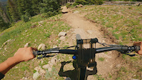
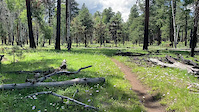
Photos of Apache Sitgreaves National Forest Mountain Bike
Videos of Apache Sitgreaves National Forest Mountain Bike
trail: Fungus
0:13 |
162 |
May 15, 2022
trail: Chipmunk Springs
0:09 |
355 |
Aug 15, 2021
trail: Sticks & Stones
3:49 |
315 |
Jan 16, 2018
trail: Sticks & Stones
5:55 |
254 |
Jul 1, 2016
trail: Sticks & Stones
2:20 |
233 |
Aug 10, 2015
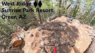
trail: RidgeWest
2:01 |
0 |
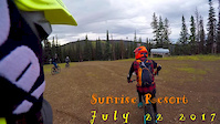
Jun 20, 2026 , Greer
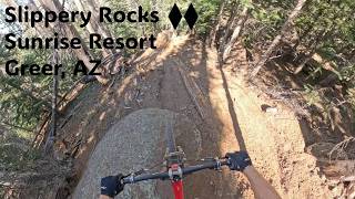
trail: Slippery Rocks
2:23 |
17 |
May 30, 2026 , Greer
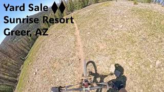
trail: Yard Sale
2:17 |
20 |
May 28, 2026 , Greer
Current Trail Warnings
| status | trail | date | condition | user | info |
|---|---|---|---|---|---|
| Poptart Sunrise Park Resort | May 30, 2026 @ 3:45pm (America/Phoenix) May 30, 2026 | Unknown | mtnstoke | Tree down on Poptart at sunrise resort |
Recent Trail Reports
Activity Feed
| username | action | type | title | date |
|---|---|---|---|---|
| MarkPxofWH | wishlist | trail | activity #97487037 | Jun 21, 2026 @ 8:21am 1 day |
| Neonguy25 | add | video | activity #97431184 | Jun 20, 2026 @ 2:01pm 2 days |
| update | event | activity #97420827 | Jun 20, 2026 @ 12:07pm 2 days | |
| Mangosmoothie | add | report | activity #97331626 | Jun 19, 2026 @ 11:10am 3 days |
| Mangosmoothie | add | report | activity #97331530 and 1 more | Jun 19, 2026 @ 11:09am 3 days |
Recent Comments
| username | type | title | comment | date |
|---|---|---|---|---|
| trail | Decent loop … add Petrified | May 30, 2026 @ 12:24pm May 30, 2026 | ||
| trail | Just rode it. Has some good flow, some... | May 30, 2026 @ 12:23pm May 30, 2026 | ||
| trail | We rode CCW today and had a great ride. It is... | Mar 25, 2026 @ 12:12pm Mar 25, 2026 | ||
| trail | This is an ATV trail. If you are looking to... | Mar 25, 2026 @ 8:10am Mar 25, 2026 | ||
| trail | Nice and dry. Good ride for February | Feb 11, 2026 @ 6:38am Feb 11, 2026 |
Local Badges
-

Descent 100k Badge0 awarded -

Descent 10k Badge2 awarded -
Descent 100k Badge0 awarded -
Descent 10k Badge10 awarded -

Epic Ride 50k38 awarded -
Epic Ride 50k23 awarded
Bike & Skill Parks
| name | type | city | rating |
|---|---|---|---|
| Sunrise Park Resort | bike park | Greer | |
| CIty of Show Low BMX | skill park | ||
| Thunder Raceway | skill park | Pinetop-Lakeside |
Upcoming Local Events
Local Trail Supporters
![]()
- Save the Buena Vista Foundation
![]()
Local Trail Supporters
![]()
- Save the Buena Vista Foundation
![]()
Activity Type Stats
| activitytype | trails | distance | descent | descent distance | total vertical | rating | global rank | state rank | photos | reports | routes | ridelogs |
|---|---|---|---|---|---|---|---|---|---|---|---|---|
| Mountain Bike | 265 | 657 miles | 66,690 ft | 313 miles | 6,693 ft | 1,045 | 1,344 | 63 | 21,952 | |||
| E-Bike | 66 | 86 miles | 22,057 ft | 61 miles | 6,693 ft | 1,116 | 7 | 1,467 | ||||
| Gravel Bike | 14 | 35 miles | 3,389 ft | 15 miles | 4,134 ft | 79 | 4 | 93 | ||||
| Winter Fat Bike | 9 | 1 | 2 | |||||||||
| Horse | 161 | 503 miles | 39,934 ft | 233 miles | 5,410 ft | 452 | 17 | 104 | ||||
| Hike | 229 | 662 miles | 55,187 ft | 304 miles | 6,998 ft | 61 | 1,178 | 42 | 3,351 | |||
| Trail Running | 226 | 658 miles | 53,950 ft | 301 miles | 6,998 ft | 20 | 1,174 | 37 | 328 | |||
| Dirtbike/Moto | 14 | 86 miles | 4,859 ft | 46 miles | 2,014 ft | 2 | 258 | 27 | ||||
| ATV/ORV/OHV | 11 | 72 miles | 4,327 ft | 40 miles | 2,014 ft | 11 | 258 | 34 | ||||
| Snowmobile | 1 | 18 miles | 1,325 ft | 15 miles | 863 ft | 58 | ||||||
| Snowshoe | 1 | 18 miles | 1,325 ft | 15 miles | 863 ft | 208 | 2 | 4 | ||||
| Downhill Ski | 49 | 25 miles | 17,526 ft | 24 miles | 1,529 ft | 1 | 215 | |||||
| Nordic Ski | 28 | 45 miles | 2,664 ft | 17 miles | 2,077 ft | 214 | 6 | 25 |
Frequently Asked Questions About Apache Sitgreaves National Forest
▼
What are the best places to ride in Apache Sitgreaves National Forest?
Apache Sitgreaves National Forest has 17 areas to explore for mountain biking. The top rated areas are:
▼
What are the highest rated mountain biking trails in Apache Sitgreaves National Forest?
The highest rated mountain biking trails in Apache Sitgreaves National Forest are:
- Jaagé (4.5/5)
- Los Burros (4.4/5)
- World Cup (4.4/5)
- Trendy Trail (4.4/5)
- RidgeWest (4.3/5)
▼
What is the best time of the year to ride in Apache Sitgreaves National Forest?
Based on ride log data, the most popular months to ride in Apache Sitgreaves National Forest are:
- July (427 activities)
- June (367 activities)
- August (315 activities)
▼
What is the longest trail in Apache Sitgreaves National Forest?
The longest trail in Apache Sitgreaves National Forest is Railroad Grade Trail at 19.1 miles. View all trails sorted by distance.
Activities
- Apache Sitgreaves National Forest Mountain Biking Trails
- Apache Sitgreaves National Forest E-Biking Trails
- Apache Sitgreaves National Forest Horseback Trails
- Apache Sitgreaves National Forest Hiking Trails
- Apache Sitgreaves National Forest Trail Running Trails
- Apache Sitgreaves National Forest Dirtbiking Trails
- Apache Sitgreaves National Forest ATVing/Offroading Trails
- Apache Sitgreaves National Forest Skiing Trails
- Apache Sitgreaves National Forest Nordic Skiing Trails
Trails
- Hard trails in Apache Sitgreaves National Forest
- Easy trails in Apache Sitgreaves National Forest
- Favorite trails in Apache Sitgreaves National Forest
- Most ridden trails in Apache Sitgreaves National Forest
- Singletrack in Apache Sitgreaves National Forest
- Viewpoint trails in Apache Sitgreaves National Forest
- Trails with technical features in Apache Sitgreaves National Forest
- Race routes in Apache Sitgreaves National Forest
Points of Interest
- Sinkhole Sight
- Wood drop TTF
- Blue Ridge Mountain Summit
- Pat Mullen Mountain Summit
- Escudilla Lookout Summit
- Top of Sunrise Peak 10640ft Viewpoint
- log ride TTF
- Mount Baldy Summit
- South Fork Little Colorado Headwaters Sight
- Black Canyon Rim Campground Camping
- Mount Ord (11,345 ft)
- Mount Thomas (11,063 ft)
- Sunrise Peak (10,640 ft)
- By schillingsworth
 TRAILFORKS HTA & contributors
 - Admins: AZT, chainslapAZ, schillingsworth, jeffgicklhorn, jpmcghee, msmcfate, cemoorelife, Schwinnshralper26
- #5140 - 8,746 views
- apache sitgreaves national forest activity log | embed map of Apache Sitgreaves National Forest mountain bike trails | apache sitgreaves national forest mountain biking points of interest polygons
Downloading of trail gps tracks in kml & gpx formats is enabled for Apache Sitgreaves National Forest.
You must login to download files.