close
-
Layers w
- Weather Layers
- Pro
- Pro
- Pro
- Pro
- Pro
- Pro
- More Layers
- Pro
- Pro
- Pro
- Pro
-
Upgrade to

3D
Trail Conditions
- Unknown
- Snow Groomed
- Snow Packed
- Snow Covered
- Snow Cover Partial
- Freeze/thaw Cycle
- Icy
- Prevalent Mud
- Wet
- Variable
- Ideal
- Dry
- Very Dry
Trail Flow (Ridden Direction)
Trailforks scans users ridelogs to determine the most popular direction each trail is ridden. A good flowing trail network will have most trails flowing in a single direction according to their intension.
The colour categories are based on what percentage of riders are riding a trail in its intended direction.
The colour categories are based on what percentage of riders are riding a trail in its intended direction.
- > 96%
- > 90%
- > 80%
- > 70%
- > 50%
- < 50%
- bi-directional trail
- no data
Trail Last Ridden
Trailforks scans ridelogs to determine the last time a trail was ridden.
- < 2 days
- < 1 week
- < 2 weeks
- < 1 month
- < 6 months
- > 6 months
Trail Ridden Direction
The intended direction a trail should be ridden.
- Downhill Only
- Downhill Primary
- Both Directions
- Uphill Primary
- Uphill Only
- One Direction
Contribute Details
Colors indicate trail is missing specified detail.
- Description
- Photos
- Description & Photos
- Videos
Trail Popularity ?
Trailforks scans ridelogs to determine which trails are ridden the most in the last 9 months.
Trails are compared with nearby trails in the same city region with a possible 25 colour shades.
Think of this as a heatmap, more rides = more kinetic energy = warmer colors.
- most popular
- popular
- less popular
- not popular
ATV/ORV/OHV Filter
Max Vehicle Width
inches
US Cell Coverage
Legend

Radar Time
Activity Recordings
Trailforks uses anonymized public activity data.
?
Activity Recordings
Trailforks uses anonymized public activity data.
?
Personal Heatmap
▶
Activity Types
all
/
none
▶
Options
2
Date range
month
–
Winter Trails
Warning
A routing network for winter maps does not exist. Selecting trails using the winter trails layer has been disabled.
Missing Trails
Most Popular
Least Popular
Trails are colored based on popularity. The more popular a trail is, the more red. Less popular trails trend towards green.
Jump Magnitude Heatmap
Heatmap of where riders jump on trails. Zoom in to see individual jumps, click circles to view jump details.
BC Backroad Status
![map legend]()
Service Road Atlas is a free to use, community-driven service for viewing and creating reports on the numerous back-country service roads around B.C. and Alberta.

Slope Aspect
Direction the slope faces
Trails Deemphasized
Trails are shown in grey.
Only show trails with no bike usage.
Suggested Layers
Based on selected activity type
Save the current map location and zoom level as your default home location whenever this page is loaded.
Save
No description for Whitefish has been added yet!
Login or register to submit one.
Activities Click to view
- Mountain Bike
304 trails
- E-Bike
42 trails
- Gravel Bike
43 trails
- Adaptive Bike
69 trails
- Winter Fat Bike
138 trails
- Horse
26 trails
- Hike
280 trails
- Trail Running
280 trails
- Dirtbike/Moto
28 trails
- ATV/ORV/OHV
17 trails
- Snowshoe
43 trails
- Downhill Ski
131 trails
- Backcountry Ski
10 trails
- Nordic Ski
49 trails
Region Details
- 59
- 11
- 72
- 123
- 29
- 8
- 2
Region Status
Open as of 22 hoursStats
- Avg Trail Rating
- Trails (view details)
- 478
- Trails Mountain Bike
- 304
- Trails E-Bike
- 42
- Trails Gravel Bike
- 43
- Trails Adaptive Bike
- 69
- Trails Winter Fat Bike
- 138
- Trails Horse
- 26
- Trails Hike
- 280
- Trails Trail Running
- 280
- Trails Dirtbike/Moto
- 28
- Trails Observed Trials
- 3
- Trails ATV/ORV/OHV
- 17
- Trails Snowmobile
- 2
- Trails Snowshoe
- 43
- Trails Downhill Ski
- 131
- Trails Backcountry Ski
- 10
- Trails Nordic Ski
- 49
- Total Distance
- 558 miles
- Total Descent
- 136,598 ft
- Total Vertical
- 5,058 ft
- Highest Trailhead
- 8,060 ft
- Reports
- 1,631
- Photos
- 719
- Ridden Counter
- 82,017
Articles
2023-Enduro-Pescado Photo Album
Aug 17, 2023 from pinkbike.com
The World's biggest biking photo gallery of photos like, crashes, north shore. 2023-Enduro-Pescado
Local Flavours: The Complete Guide to Riding in Whitefish, Montana
Aug 8, 2019 from pinkbike.com
Everything you need to know about mountain biking in this beautiful playground in the mountains.
Sub Regions
-
Beaver Lakes Trails
- 1
- 21
- 8
-
Big Mountain Nordic
- 3
- 4
-
Finger Lake
- 1
- 2
- 1
-
Haskill Basin
- 2
- 1
-
Holbrook Overlook
-
Lion Mountain
- 1
-
Pig Farms
- 29
- 52
-
Spencer Mountain
- 1
- 11
- 3
- 3
-
Tally Lake Area
- 2
- 25
- 5
- 1
-
Whitefish Legacy Center
- 3
- 3
-
Whitefish Mountain Resort
- 1
- 2
- 7
- 9
- 4
- 1
-
Whitefish Range
- 1
- 1
- 13
- 2
Popular Whitefish Mountain Biking Trails
• 100 ★ 4.5 • 3 miles • 0 ft • 1,235 •
Only one word can describe this trail: flow! Intersecting six times, it’s perfect for intermediate-to-advanced riders who like to find their groove. Connects to the top of the B-Side Zone.
• 100 ★ 4.0 • 3,255 ft • 176 ft • 1,218 •
Quick Climb that takes you from the Spencer Access Road to a multiple downhill trails. Follow the trail to the top of the ridge where you'll have a great view of the valley to the west. From there you can access, , , , , and .
• 100 ★ 4.8 • 5 miles • 372 ft • 1,040 •
Highly rated popular blue difficulty singletrack. This multi-use trail can be used both directions and has a moderate overall physical rating with a 372 ft blue climb. It features berm. On average it takes 36 minutes to complete this trail.
• 95 ★ 4.3 • 2 miles • 221 ft • 879 •
Short Overlook Look that has mellow slightly bermed out corners, flows a little better than sections of the trail closer to town.
• 95 ★ 4.3 • 1 mile • 15 ft • 875 •
Great trail with more rooty and rocky steep sections than but mostly natural; not as many built features as some other trails in this area. It has some optional smaller airs as well as some more technical downhill sections. A great next...
• 95 ★ 4.4 • 1,722 ft • 0 ft • 863 •
Flowy trail filled with berms and step-ups, perfect for beginner-to-intermediate riders looking to rip some bigger berms. Connects the lift plaza to the base area.
• 95 ★ 4.0 • 1,558 ft • 0 ft • 844 •
Jumps and tables for intermediate riders to practice catching air. Connects the top of the Bad Rock Zone to the village area.
Whitefish Mountain Bike Routes
The Grand Loop Featured
★ 5.0 • 16 miles • 1,930 ft • 16 • Loop •
If you want to experience the best of Beaver Lakes, then this riding area, which includes views, flow, and...
Beaver Lakes Gravel Grind Featured
★ 4.0 • 10 miles • 863 ft • 2 • Loop •
A great gravel grinder that travels around the western perimeter and then south through the heart of the...
2 miles • 6 ft • 1 •
This is one of our favorite routes in Whitefish and is featured in Freehub Magazine's Montana Photo Book:...
2 miles • 458 ft • 4 •
Starting in the Chair 1 Lift Plaza this week! Up Lime Light, Down all the way to the Magic Carpet Zone,...
5 miles • 898 ft • 1 • Loop •
The Woods Lake Overlook is a newer section of the Whitefish Trail. It is smooth and not technically...
3 miles • 456 ft • 2 •
This is one of our favorite routes in Whitefish and is featured in Freehub Magazine's Montana Photo Book:...
Photos of Whitefish Mountain Bike
Videos of Whitefish Mountain Bike

trail: Malice in Plunderland
0:11 |
41 |
Sep 3, 2025
trail: Zeppelin Alt (Drop)
0:45 |
54 |
Nov 22, 2023
trail: Kashmir
4:39 |
26 |
Nov 22, 2023
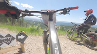
trail: Skynyrd
0:15 |
75 |
Nov 22, 2023

trail: Freebird
0:12 |
|
Jul 29, 2023
trail: Freebird
0:12 |
|
Jul 29, 2023
trail: Zeppelin
0:58 |
|
Jul 8, 2021
trail: Otter Pop
0:12 |
149 |
Feb 21, 2021
Current Trail Warnings
| status | trail | date | condition | user | info |
|---|---|---|---|---|---|
| The Whitefish Trail - East Spencer Loop | Jun 5, 2026 @ 1:47pm (America/Denver) Jun 5, 2026 | Prevalent Mud | toast2266 | north end of singletrack is completely... | |
| Ashley Mountain | Jun 4, 2026 @ 8:13pm (America/Denver) Jun 4, 2026 | Variable | AESchneider612 | Completely impassable with down trees.... | |
| Reid Divide | May 29, 2026 @ 11:29am (America/Denver) May 29, 2026 | Dry | FAMB FAMB | Closed until further notice for timber... |
Recent Trail Reports
| status | trail | date | condition | info | user |
|---|---|---|---|---|---|
| Bill Creek | May 29, 2026 @ 11:07am (America/Denver) May 29, 2026 | Ideal | FAMB FAMB | ||
| Ingalls - Mt Connor | May 22, 2026 @ 3:40pm (America/Denver) May 22, 2026 | Ideal | FAMB FAMB | ||
| connector | May 9, 2026 @ 11:59am (America/Creston) May 9, 2026 | Ideal | JeffVonKiper | ||
| connector | May 9, 2026 @ 11:59am (America/Creston) May 9, 2026 | Ideal | JeffVonKiper | ||
| PF-27 | May 9, 2026 @ 11:59am (America/Creston) May 9, 2026 | Ideal | JeffVonKiper | ||
| PF-23 | May 9, 2026 @ 11:59am (America/Creston) May 9, 2026 | Ideal | JeffVonKiper | ||
| South Ridge Trail | May 9, 2026 @ 4:20pm (America/Denver) May 9, 2026 | Ideal | easmith | ||
| Boney Gulch | May 2, 2026 @ 3:16pm (America/Denver) May 2, 2026 | Dry | MaxMMM | ||
| PF-7 | Apr 30, 2026 @ 5:22pm (America/Denver) Apr 30, 2026 | Unknown | bosburn | ||
| PF-37 | Apr 30, 2026 @ 5:21pm (America/Denver) Apr 30, 2026 | Unknown | bosburn |
Activity Feed
| username | action | type | title | date |
|---|---|---|---|---|
| beachysdan | wishlist | route | activity #97272786 | Jun 18, 2026 @ 1:19pm 3 days |
| 2998BqZ9 | wishlist | route | activity #97258171 | Jun 18, 2026 @ 9:37am 3 days |
| 2998BqZ9 | wishlist | trail | activity #97198942 | Jun 17, 2026 @ 11:32am Jun 17, 2026 |
| 2998BqZ9 | wishlist | route | activity #97198816 | Jun 17, 2026 @ 11:30am Jun 17, 2026 |
| 2998BqZ9 | wishlist | route | activity #97198680 | Jun 17, 2026 @ 11:29am Jun 17, 2026 |
Recent Comments
| username | type | title | comment | date |
|---|---|---|---|---|
| trail | Uh | Jun 15, 2026 @ 8:43am Jun 15, 2026 | ||
| trail | yup! a good progress trail---:) | Jun 6, 2026 @ 6:24pm Jun 6, 2026 | ||
| trail | for sure---i need a clinic for those... | Jun 6, 2026 @ 6:23pm Jun 6, 2026 | ||
| trail | Oh Otter Pop---your bank turns get me EVERY... | Jun 6, 2026 @ 6:21pm Jun 6, 2026 | ||
| trail | i’m | Jun 5, 2026 @ 9:33pm Jun 5, 2026 |
Local Badges
-

Completionist2 awarded -
Completionist0 awarded -

Epic Ride 50k1,638 awarded -

Top 10 Trails6 awarded -
Completionist0 awarded -
Completionist2 awarded
Bike & Skill Parks
| name | type | city | rating |
|---|---|---|---|
| Whitefish Mountain Resort | bike park | Whitefish | |
| Armory Park Pump Track | skill park | Whitefish |
Upcoming Local Events
Local Trail Supporters
- Flathead Fat Tires
![]()
![]()
![National Recreation Trail]()
- whitefish mountain resort
Local Trail Supporters
- Flathead Fat Tires
![]()
![]()
![National Recreation Trail]()
- whitefish mountain resort
Activity Type Stats
| activitytype | trails | distance | descent | descent distance | total vertical | rating | global rank | state rank | photos | reports | routes | ridelogs |
|---|---|---|---|---|---|---|---|---|---|---|---|---|
| Mountain Bike | 304 | 471 miles | 87,484 ft | 217 miles | 5,059 ft | #164 | #62 | 649 | 1,605 | 30 | 38,498 | |
| E-Bike | 42 | 146 miles | 15,663 ft | 65 miles | 4,193 ft | #1,039 | #802 | 1,058 | 1 | 404 | ||
| Gravel Bike | 43 | 63 miles | 4,121 ft | 17 miles | 3,907 ft | #68 | #775 | 13 | 140 | 2 | 210 | |
| Adaptive Bike | 69 | 129 miles | 10,131 ft | 50 miles | 3,930 ft | #22 | #1,240 | 174 | 6 | |||
| Winter Fat Bike | 138 | 127 miles | 21,115 ft | 52 miles | 4,508 ft | #14 | #767 | 582 | 1 | 3 | ||
| Horse | 26 | 118 miles | 14,222 ft | 56 miles | 4,170 ft | #286 | #454 | 447 | 46 | |||
| Hike | 280 | 388 miles | 69,108 ft | 159 miles | 5,059 ft | #177 | #99 | 25 | 1,537 | 2 | 3,876 | |
| Trail Running | 280 | 388 miles | 69,108 ft | 159 miles | 5,059 ft | #153 | #68 | 5 | 1,536 | 2 | 3,620 | |
| Dirtbike/Moto | 28 | 145 miles | 17,615 ft | 65 miles | 4,091 ft | #159 | #97 | 472 | 52 | |||
| Observed Trials | 3 | 1 mile | 374 ft | 2,326 ft | 361 ft | 6 | 70 | |||||
| ATV/ORV/OHV | 17 | 113 miles | 13,205 ft | 54 miles | 4,091 ft | #123 | #60 | 440 | 28 | |||
| Snowmobile | 2 | 26 miles | 3,428 ft | 17 miles | 2,726 ft | 14 | 6 | |||||
| Snowshoe | 43 | 75 miles | 10,082 ft | 41 miles | 3,071 ft | #200 | #50 | 36 | 54 | |||
| Downhill Ski | 131 | 53 miles | 46,417 ft | 51 miles | 2,254 ft | #53 | #24 | 2 | 12 | 2 | 3,498 | |
| Backcountry Ski | 10 | 38 miles | 4,528 ft | 22 miles | 2,858 ft | #62 | #13 | 14 | 4 | 2,939 | ||
| Nordic Ski | 49 | 35 miles | 3,711 ft | 16 miles | 1,434 ft | #45 | #11 | 19 | 27 | 2 | 2,554 |
Frequently Asked Questions About Whitefish
▼
What are the best places to ride in Whitefish?
Whitefish has 15 areas to explore for mountain biking. The top rated areas are:
▼
What are the highest rated mountain biking trails in Whitefish?
The highest rated mountain biking trails in Whitefish are:
- Reservoir Trail (4.6/5)
- Malice in Plunderland (4.5/5)
- Otter Pop (4.5/5)
- Runaway Train (4.4/5)
- Kashmir (4.3/5)
▼
What is the best time of the year to ride in Whitefish?
Based on ride log data, the most popular months to ride in Whitefish are:
- July (1,274 activities)
- August (885 activities)
- June (772 activities)
▼
Where can I park to ride in Whitefish?
There are 58 parking locations listed in Whitefish. The most popular parking spots are: View all parking and trailhead locations on the map to plan your visit.
Activities
- Whitefish Mountain Biking Trails
- Whitefish E-Biking Trails
- Whitefish Gravel Biking Trails
- Whitefish Adaptive Biking Trails
- Whitefish Winter Fat Biking Trails
- Whitefish Horseback Trails
- Whitefish Hiking Trails
- Whitefish Trail Running Trails
- Whitefish Dirtbiking Trails
- Whitefish ATVing/Offroading Trails
- Whitefish Snowshoeing Trails
- Whitefish Skiing Trails
- Whitefish Backcountry Skiing Trails
- Whitefish Nordic Skiing Trails
Trails
Points of Interest
- Whitefish Trail Learning Pavilion Cabin
- Base Lodge
- Summit House Lodge
- Skinny TTF
- Nasukoin Mountain Summit
- Lake Mountain Summit
- Hornet Mountain Summit
- Whitefish Mountain Summit - (2,065m / 6,775ft)
- Chair 2 Loading Other
- Chair 2 Off-loading Other
- Nasukoin Mountain (8,048 ft)
- Lake Mountain (7,802 ft)
- Moose Peak (7,523 ft)
- By brenthillier
 NSMBA TRAILFORKS & contributors
 - Admins: FAMB, JeffVonKiper
- #4158 - 39,846 views
- whitefish activity log | embed map of Whitefish mountain bike trails | whitefish mountain biking points of interest
Downloading of trail gps tracks in kml & gpx formats is enabled for Whitefish.
You must login to download files.