close
-
Layers w
- Weather Layers
- Pro
- Pro
- Pro
- Pro
- Pro
- Pro
- More Layers
- Pro
- Pro
- Pro
- Pro
-
Upgrade to

3D
Trail Conditions
- Unknown
- Snow Groomed
- Snow Packed
- Snow Covered
- Snow Cover Partial
- Freeze/thaw Cycle
- Icy
- Prevalent Mud
- Wet
- Variable
- Ideal
- Dry
- Very Dry
Trail Flow (Ridden Direction)
Trailforks scans users ridelogs to determine the most popular direction each trail is ridden. A good flowing trail network will have most trails flowing in a single direction according to their intension.
The colour categories are based on what percentage of riders are riding a trail in its intended direction.
The colour categories are based on what percentage of riders are riding a trail in its intended direction.
- > 96%
- > 90%
- > 80%
- > 70%
- > 50%
- < 50%
- bi-directional trail
- no data
Trail Last Ridden
Trailforks scans ridelogs to determine the last time a trail was ridden.
- < 2 days
- < 1 week
- < 2 weeks
- < 1 month
- < 6 months
- > 6 months
Trail Ridden Direction
The intended direction a trail should be ridden.
- Downhill Only
- Downhill Primary
- Both Directions
- Uphill Primary
- Uphill Only
- One Direction
Contribute Details
Colors indicate trail is missing specified detail.
- Description
- Photos
- Description & Photos
- Videos
Trail Popularity ?
Trailforks scans ridelogs to determine which trails are ridden the most in the last 9 months.
Trails are compared with nearby trails in the same city region with a possible 25 colour shades.
Think of this as a heatmap, more rides = more kinetic energy = warmer colors.
- most popular
- popular
- less popular
- not popular
ATV/ORV/OHV Filter
Max Vehicle Width
inches
US Cell Coverage
Legend

Radar Time
Activity Recordings
Trailforks uses anonymized public activity data.
?
Activity Recordings
Trailforks uses anonymized public activity data.
?
Personal Heatmap
▶
Activity Types
all
/
none
▶
Options
2
Date range
month
–
Winter Trails
Warning
A routing network for winter maps does not exist. Selecting trails using the winter trails layer has been disabled.
Missing Trails
Most Popular
Least Popular
Trails are colored based on popularity. The more popular a trail is, the more red. Less popular trails trend towards green.
Jump Magnitude Heatmap
Heatmap of where riders jump on trails. Zoom in to see individual jumps, click circles to view jump details.
BC Backroad Status
![map legend]()
Service Road Atlas is a free to use, community-driven service for viewing and creating reports on the numerous back-country service roads around B.C. and Alberta.

Slope Aspect
Direction the slope faces
Trails Deemphasized
Trails are shown in grey.
Only show trails with no bike usage.
Suggested Layers
Based on selected activity type
Save the current map location and zoom level as your default home location whenever this page is loaded.
SavePopular Trail Networks
view all areas »
No description for Whitehorse has been added yet!
Login or register to submit one.
Activities Click to view
- Mountain Bike
555 trails
- E-Bike
581 trails
- Gravel Bike
0 trails
- Adaptive Bike
0 trails
- Winter Fat Bike
3 trails
- Horse
48 trails
- Hike
566 trails
- Trail Running
561 trails
- Dirtbike/Moto
54 trails
- Observed Trials
12 trails
- ATV/ORV/OHV
34 trails
- Snowmobile
32 trails
- Snowshoe
96 trails
- Backcountry Ski
22 trails
- Nordic Ski
69 trails
Region Details
- 61
- 3
- 182
- 266
- 31
- 8
Region Status
Caution as of 1 dayLocal Trail Association
Stats
- Avg Trail Rating
- Trails (view details)
- 574
- Trails Mountain Bike
- 556
- Trails E-Bike
- 581
- Trails Winter Fat Bike
- 3
- Trails Horse
- 48
- Trails Hike
- 566
- Trails Trail Running
- 561
- Trails Dirtbike/Moto
- 54
- Trails Observed Trials
- 12
- Trails ATV/ORV/OHV
- 34
- Trails Snowmobile
- 32
- Trails Snowshoe
- 96
- Trails Backcountry Ski
- 22
- Trails Nordic Ski
- 69
- Total Distance
- 517 miles
- Total Descent
- 60,380 ft
- Total Vertical
- 3,573 ft
- Highest Trailhead
- 5,673 ft
- Reports
- 6,676
- Photos
- 1,365
- Ridden Counter
- 41,347
Articles
Video: Land of the Midnight Rain - A Perfectly Documented Very Long Day Out
Dec 18, 2025 from pinkbike.com
Featuring one of Pinkbike's bubbliest former staff members.

The Yukon: Land of the Midnight Fun
Sep 8, 2025 from pinkbike.com
Mountain biking the Yukon: deep loam, no lines and the days never end.
Video: Slabs Galore on Yukon's Latest Trail - Rock Lobster
Jun 3, 2020 from pinkbike.com
2 summers in the making, Whitehorse's trail network gets another great addition.
Sub Regions
-
Crestview
- 3
-
Grey Mountain
- 18
- 58
- 11
- 2
-
Gunnar Nilsson and Mickey Lammers Research Forest
- 7
- 1
-
Haeckel Hill
- 2
- 3
- 1
-
Hillcrest
- 31
- 37
- 1
-
MacPherson
- 3
- 7
-
Mary Lake/Cowley Lake
- 8
- 9
- 5
- 2
-
Mount Sima
- 3
-
Mt McIntyre
- 1
- 22
- 45
- 5
- 1
-
Mt. Sima Bike Park
- 2
- 1
- 2
-
Pilot Mountain
- 2
- 9
- 1
-
Pineridge
- 14
- 6
-
Porter Creek
- 10
- 18
-
Range Point
- 2
- 1
-
Spruce Hill
- 1
-
Takhini
- 5
- 7
-
Whistle Bend
- 6
- 9
-
Whitehorse Airport
- 1
- 4
- 4
- 2
-
Wolf Creek
- 14
- 10
-
Wolf Creek Campground
- 1
- 5
- 3
-
Yukon RC Modellers Airfield
- 13
- 4
-
Yukon University
- 8
- 23
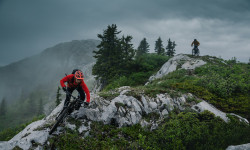
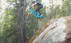
Popular Whitehorse Mountain Biking Trails
• 100 ★ 4.2 • 1,453 ft • 0 ft • 645 •
Fast and flowy trail without features.
• 100 ★ 3.8 • 1 mile • 49 ft • 548 •
This trail drops down past old squatter cabins to a ridge overlooking Whitehorse before dropping down through a gully. Although the trail is technically bidirectional it "downhill" dominant (i.e. south to north)
• 100 ★ 3.0 • 1,158 ft • 103 ft • 512 •
Popular blue difficulty singletrack. This mountain bike primary trail can be used both directions and has a moderate overall physical rating with a 103 ft blue climb. On average it takes 4 minutes to complete this trail.
• 100 ★ 4.0 • 5,095 ft • 302 ft • 408 •
Dominantly used as a climb trail, is very rooty and a long climb with some steep pitches. It is typically only fat bike groomed as far as .
• 100 ★ 0.0 • 1,670 ft • 19 ft • 388 •
A rolling traverse semi-double track.
• 90 ★ 3.8 • 3 miles • 436 ft • 378 •
A challenging climb up into the alpine leads to a fast, loamy and rooty descent down to the Fraser ski trails. Typically accessed by riding or shuttling the road to first and then after Starbuck's Revenge make your way to and This trail...
• 100 ★ 4.4 • 3,596 ft • 8 ft • 374 •
Popular blue difficulty singletrack. This mountain bike primary trail can be used downhill primary and has a moderate overall physical rating. It features drop and rock face. On average it takes 4 minutes to complete this trail.
• 100 ★ 2.0 • 1 mile • 322 ft • 371 •
Old double track is dominantly a climb. Groomed in winter for fat bikes
Whitehorse Mountain Bike Routes
★ 5.0 • 3 miles • 154 ft • 4 • Point to Point •
Show me the money! Huge mountain vistas and views over looking Whitehorse. Starts from the Grey Mountain...
2 miles • 313 ft • 4 • Loop •
This Beginner to intermediate loop starts at the bike park parking lot, with a gentle ascend up Lower...
3 miles • 52 ft • 1 • Shuttled •
Great Beginner Shuttle Lap on Grey Mountain. Enjoy wide trails, scenic views, some flow, as well...
6 miles • 1,143 ft • 6 •
Dirt Girls - - - Blues Brothers loop for Advanced riders
5 miles • 725 ft • 5 •
Dirt Girls - - Blues Brothers loop for Intermediate 2 riders
7 miles • 785 ft • 11 •
Dirt Girls - - - loop for Intermediate 1 and 2 riders
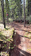
Photos of Whitehorse Mountain Bike
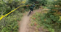
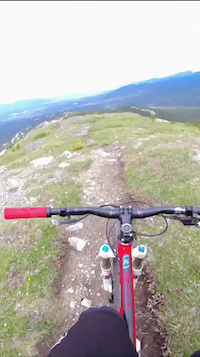
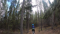
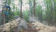
Videos of Whitehorse Mountain Bike
trail: Katima Trail
0:32 |
|
Jun 11, 2026
0:05 |
9 |
Dec 29, 2025
trail: Lefty Loosey
4:29 |
36 |
Dec 10, 2025
trail: The Dream
0:42 |
18 |
Jul 6, 2025

trail: Rock Lobster
0:22 |
126 |
Dec 30, 2023

trail: Lefty Loosey
4:29 |
94 |
Sep 1, 2023
trail: The Road Runner
4:43 |
72 |
May 23, 2021
trail: Rock Lobster
0:53 |
402 |
May 31, 2020
Recent Trail Reports
| status | trail | date | condition | info | user |
|---|---|---|---|---|---|
| Kid Vicious! | Jun 14, 2026 @ 1:57pm (America/Whitehorse) Jun 14, 2026 | Unknown | sylvturc | ||
| Hidden Lakes East | Jun 1, 2026 @ 7:19pm (America/Whitehorse) Jun 1, 2026 | Dry | yukonutahn | ||
| Connector | Jun 1, 2026 @ 7:19pm (America/Whitehorse) Jun 1, 2026 | Unknown | yukonutahn | ||
| Ice Lake Trail | Jun 3, 2026 @ 6:44pm (America/Whitehorse) Jun 3, 2026 | Wet | stopsforberries | ||
| Birch Loop | May 27, 2026 @ 8:43am (America/Whitehorse) May 27, 2026 | Ideal | Jasonww6 | ||
| Upper Riverdale Trail | May 22, 2026 @ 8:30pm (America/Whitehorse) May 22, 2026 | Unknown | P2QKK1 | ||
| Booby Trap | May 18, 2026 @ 1:16pm (America/Whitehorse) May 18, 2026 | Ideal | PrinceB | ||
| Upper Boogaloo | May 18, 2026 @ 1:01pm (America/Whitehorse) May 18, 2026 | Ideal | PrinceB | ||
| Sweet Dreams | May 16, 2026 @ 9:06pm (America/Whitehorse) May 16, 2026 | Ideal | sarahbiss | ||
| Blue's Brother | May 16, 2026 @ 9:05pm (America/Whitehorse) May 16, 2026 | Ideal | sarahbiss |
Activity Feed
| username | action | type | title | date |
|---|---|---|---|---|
| ThomasLLidrr | ridden | trail | activity #97298867 | Jun 18, 2026 @ 11:11pm 1 day |
| Sue57 | ridden | trail | activity #97210656 | Jun 17, 2026 @ 2:48pm 2 days |
| 1temujin | ridden | trail | activity #97207152 | Jun 17, 2026 @ 1:38pm 2 days |
| dkotylak | comment | trail | activity #97128648 | Jun 16, 2026 @ 11:55am Jun 16, 2026 |
| Mapa | wishlist | route | activity #97126865 | Jun 16, 2026 @ 11:34am Jun 16, 2026 |
Recent Comments
| username | type | title | comment | date |
|---|---|---|---|---|
| trail | Quit your birch’en… These are birch trees... | Jun 16, 2026 @ 11:55am Jun 16, 2026 | ||
| report | Big tree down when you get in the trees before... | Jun 14, 2026 @ 4:04pm Jun 14, 2026 | ||
| report | Np | Jun 14, 2026 @ 3:55pm Jun 14, 2026 | ||
| trail | Dry and fun. Echo the post above this one. | Jun 1, 2026 @ 6:47pm Jun 1, 2026 | ||
| report | Thanks to whoever cleared the tree :) | May 31, 2026 @ 7:41am May 31, 2026 |
Local Badges
-

Completionist0 awarded -

Top 10 Trails3 awarded -
Completionist0 awarded -
Completionist1 awarded -
Completionist0 awarded -
Completionist0 awarded
Bike & Skill Parks
| name | type | city | rating |
|---|---|---|---|
| Mt. Sima Bike Park | bike park | Whitehorse | |
| Dirt n' Soul Mountain Bike Skills Park | skill park | Whitehorse | |
| Skill park | skill park | Whitehorse | |
| Gunnar Nilsson & Mickey Lammers Bike Skills Park | skill park | Whitehorse | |
| Gunnar Nilsson & Mickey Lammers Research Forest Park | skill park | Whitehorse |
Local Mountain Biking Directory
-
Boréale BikingGuides & Tours
![Boréale Biking]()
-
Contagious Mountain Bike Club
![Contagious Mountain Bike Club]()
-
Cadence CyclesBike Shop
-
Icycle SportBike Shop
Activity Type Stats
| activitytype | trails | distance | descent | descent distance | total vertical | rating | global rank | state rank | photos | reports | routes | ridelogs |
|---|---|---|---|---|---|---|---|---|---|---|---|---|
| Mountain Bike | 555 | 447 miles | 53,294 ft | 187 miles | 3,035 ft | #156 | #1 | 1,231 | 6,535 | 48 | 33,293 | |
| E-Bike | 581 | 109 miles | 8,156 ft | 40 miles | 2,520 ft | #254 | #1 | 30 | 2,285 | 7 | 1,372 | |
| Winter Fat Bike | 3 | #21 | #1 | 2 | 69 | 1 | 112 | |||||
| Horse | 48 | 84 miles | 6,581 ft | 32 miles | 3,015 ft | #210 | #1 | 652 | 1 | |||
| Hike | 566 | 452 miles | 53,136 ft | 183 miles | 3,573 ft | #132 | #1 | 58 | 6,472 | 7 | 3,068 | |
| Trail Running | 561 | 448 miles | 50,807 ft | 182 miles | 3,100 ft | #84 | #1 | 3 | 6,472 | 15 | 6,460 | |
| Dirtbike/Moto | 54 | 87 miles | 5,249 ft | 32 miles | 3,015 ft | #141 | #1 | 2 | 540 | 34 | ||
| Observed Trials | 12 | 36 miles | 1,683 ft | 13 miles | 2,165 ft | #27 | #1 | 62 | 6 | |||
| ATV/ORV/OHV | 34 | 76 miles | 3,825 ft | 26 miles | 3,015 ft | #66 | #1 | 546 | 22 | |||
| Snowmobile | 32 | 79 miles | 4,580 ft | 31 miles | 3,015 ft | #28 | #1 | 181 | 14 | |||
| Snowshoe | 96 | 112 miles | 7,057 ft | 42 miles | 3,025 ft | #59 | #1 | 450 | 3 | 161 | ||
| Backcountry Ski | 22 | 82 miles | 4,180 ft | 34 miles | 3,022 ft | #114 | #1 | 108 | 1 | 255 | ||
| Nordic Ski | 69 | 88 miles | 7,024 ft | 33 miles | 3,025 ft | #16 | #1 | 28 | 387 | 7,642 |
Frequently Asked Questions About Whitehorse
▼
What are the best places to ride in Whitehorse?
Whitehorse has 22 areas to explore for mountain biking. The top rated areas are:
▼
What are the highest rated mountain biking trails in Whitehorse?
The highest rated mountain biking trails in Whitehorse are:
- Kid Vicious! (4.6/5)
- Rock Lobster (4.5/5)
- Inline Descent (4.5/5)
- Haeckel Hill DH Upper (4.5/5)
- Lefty Loosey (4.5/5)
▼
What is the best time of the year to ride in Whitehorse?
Based on ride log data, the most popular months to ride in Whitehorse are:
- July (760 activities)
- June (638 activities)
- August (515 activities)
▼
Where can I park to ride in Whitehorse?
There are 31 parking locations listed in Whitehorse. The most popular parking spots are: View all parking and trailhead locations on the map to plan your visit.
Activities
- Whitehorse Mountain Biking Trails
- Whitehorse E-Biking Trails
- Whitehorse Horseback Trails
- Whitehorse Hiking Trails
- Whitehorse Trail Running Trails
- Whitehorse Dirtbiking Trails
- Whitehorse Observed Trials Trails
- Whitehorse ATVing/Offroading Trails
- Whitehorse Snowmobiling Trails
- Whitehorse Snowshoeing Trails
- Whitehorse Backcountry Skiing Trails
- Whitehorse Nordic Skiing Trails
Trails
- By brenthillier
 NSMBA TRAILFORKS & contributors
 - Admins: brittseels, CMBC, COW, S2Syukon-trails
- #3348 - 65,238 views
- whitehorse activity log | embed map of Whitehorse mountain bike trails | whitehorse mountain biking points of interest polygons
Downloading of trail gps tracks in kml & gpx formats is enabled for Whitehorse.
You must login to download files.