close
-
Layers w
- Weather Layers
- Pro
- Pro
- Pro
- Pro
- Pro
- Pro
- More Layers
- Pro
- Pro
- Pro
- Pro
-
Upgrade to

3D
Trail Conditions
- Unknown
- Snow Groomed
- Snow Packed
- Snow Covered
- Snow Cover Partial
- Freeze/thaw Cycle
- Icy
- Prevalent Mud
- Wet
- Variable
- Ideal
- Dry
- Very Dry
Trail Flow (Ridden Direction)
Trailforks scans users ridelogs to determine the most popular direction each trail is ridden. A good flowing trail network will have most trails flowing in a single direction according to their intension.
The colour categories are based on what percentage of riders are riding a trail in its intended direction.
The colour categories are based on what percentage of riders are riding a trail in its intended direction.
- > 96%
- > 90%
- > 80%
- > 70%
- > 50%
- < 50%
- bi-directional trail
- no data
Trail Last Ridden
Trailforks scans ridelogs to determine the last time a trail was ridden.
- < 2 days
- < 1 week
- < 2 weeks
- < 1 month
- < 6 months
- > 6 months
Trail Ridden Direction
The intended direction a trail should be ridden.
- Downhill Only
- Downhill Primary
- Both Directions
- Uphill Primary
- Uphill Only
- One Direction
Contribute Details
Colors indicate trail is missing specified detail.
- Description
- Photos
- Description & Photos
- Videos
Trail Popularity ?
Trailforks scans ridelogs to determine which trails are ridden the most in the last 9 months.
Trails are compared with nearby trails in the same city region with a possible 25 colour shades.
Think of this as a heatmap, more rides = more kinetic energy = warmer colors.
- most popular
- popular
- less popular
- not popular
ATV/ORV/OHV Filter
Max Vehicle Width
inches
US Cell Coverage
Legend

Radar Time
Activity Recordings
Trailforks uses anonymized public activity data.
?
Activity Recordings
Trailforks uses anonymized public activity data.
?
Personal Heatmap
▶
Activity Types
all
/
none
▶
Options
2
Date range
month
–
Winter Trails
Warning
A routing network for winter maps does not exist. Selecting trails using the winter trails layer has been disabled.
Missing Trails
Most Popular
Least Popular
Trails are colored based on popularity. The more popular a trail is, the more red. Less popular trails trend towards green.
Jump Magnitude Heatmap
Heatmap of where riders jump on trails. Zoom in to see individual jumps, click circles to view jump details.
BC Backroad Status
![map legend]()
Service Road Atlas is a free to use, community-driven service for viewing and creating reports on the numerous back-country service roads around B.C. and Alberta.

Slope Aspect
Direction the slope faces
Trails Deemphasized
Trails are shown in grey.
Only show trails with no bike usage.
Suggested Layers
Based on selected activity type
Save the current map location and zoom level as your default home location whenever this page is loaded.
SaveThis region is Unsanctioned, Ride at your own Risk!
A diverse collection of trails near the Bayers Lake Industrial Park. This is some of the best riding in Halifax.
NOTE: As of Spring 2015 - some of the original trails behind Burger King were destroyed to make way for an expansion of the Bayers Lake Industrial Park. These trails have been removed from Trailforks. The remaining trails are outside of the development zone and remain intact and rideable.
NOTE: As of Spring 2015 - some of the original trails behind Burger King were destroyed to make way for an expansion of the Bayers Lake Industrial Park. These trails have been removed from Trailforks. The remaining trails are outside of the development zone and remain intact and rideable.
 google parking directions
 Access Info:
The BLT rail trail parking lot on Lakeside Park Dr.
Activities Click to view
- Mountain Bike
15 trails
- Horse
2 trails
- Hike
15 trails
- Trail Running
15 trails
- Dirtbike/Moto
3 trails
- ATV/ORV/OHV
2 trails
- Snowmobile
2 trails
- Snowshoe
13 trails
- Nordic Ski
4 trails
Region Details
- 5
- 8
- 2
Region Status
Caution as of May 23, 2026Stats
- Avg Trail Rating
- Trails (view details)
- 15
- Trails Mountain Bike
- 15
- Trails E-Bike
- 2
- Trails Horse
- 2
- Trails Hike
- 15
- Trails Trail Running
- 15
- Trails Dirtbike/Moto
- 3
- Trails ATV/ORV/OHV
- 2
- Trails Snowmobile
- 2
- Trails Snowshoe
- 13
- Trails Nordic Ski
- 4
- Total Distance
- 9 miles
- Total Descent
- 1,148 ft
- Total Vertical
- 185 ft
- Highest Trailhead
- 427 ft
- Reports
- 271
- Photos
- 84
- Ridden Counter
- 2,046
Popular Whopper Dropper Mountain Biking Trails
• 80 ★ 4.6 • 1 mile • 141 ft • 194 •
Tight single track with some fun technical climbing turns with some roots. Not a lot of granite unlike rest of Whopper trail system. Please don't ride it when it's too wet, as it's far too easy to damage this trail when it's soggy out.
• 90 ★ 3.5 • 666 ft • 0 ft • 192 •
Popular blue difficulty singletrack. This multi-use trail can be used both directions and has a easy overall physical rating with a 0 ft green climb. On average it takes 1 minutes to complete this trail.
• 75 ★ 2.8 • 971 ft • 33 ft • 163 •
Popular blue difficulty singletrack. This multi-use trail can be used both directions and has a moderate overall physical rating with a 33 ft blue climb. On average it takes 4 minutes to complete this trail.
• 85 ★ 4.2 • 1,709 ft • 44 ft • 159 •
Popular blue difficulty singletrack. This multi-use trail can be used both directions and has a moderate overall physical rating with a 44 ft blue climb. On average it takes 4 minutes to complete this trail.
• 75 ★ 4.0 • 2,418 ft • 58 ft • 135 •
Popular black diamond difficulty singletrack. This multi-use trail can be used downhill primary and has a moderate overall physical rating with a 58 ft blue climb. It features rock face. On average it takes 8 minutes to complete this trail.
• 75 ★ 4.0 • 2 miles • 152 ft • 134 •
Popular blue difficulty singletrack. This multi-use trail can be used both directions. It features bridge and rock face. On average it takes 42 minutes to complete this trail.
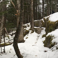
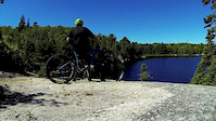
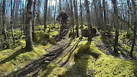
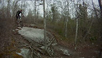
Photos of Whopper Dropper Mountain Bike
Videos of Whopper Dropper Mountain Bike
trail: Scotch on the Rocks
0:09 |
471 |
May 18, 2018
trail: (Suzie) Lake Loop
3:24 |
796 |
Sep 10, 2016
trail: Whopper to Suzie Q connector
0:00 |
369 |
Apr 24, 2016

trail: Whopper To Powerline
0:27 |
537 |
Jul 26, 2015

0:16 |
155 |
Aug 23, 2014

0:25 |
320 |
Dec 4, 2013

0:22 |
399 |
Sep 21, 2012
0:25 |
163 |
Jun 23, 2012
Current Trail Warnings
| status | trail | date | condition | user | info |
|---|---|---|---|---|---|
| Suzie Q | May 23, 2026 @ 1:39pm (America/Halifax) May 23, 2026 | Variable | gearscc RRT | Very grown in. Mix of ride and hike-a-bike. | |
| Fire Road | May 23, 2026 @ 1:39pm (America/Halifax) May 23, 2026 | Wet | gearscc RRT | Big puddles |
Recent Trail Reports
| status | trail | date | condition | info | user |
|---|---|---|---|---|---|
| Da Minion Ext | May 23, 2026 @ 1:39pm (America/Halifax) May 23, 2026 | Variable | gearscc RRT | ||
| Scotch on the Rocks | Oct 10, 2025 @ 12:16pm (America/Halifax) Oct 10, 2025 | Dry | KevinQ5s8l | ||
| Whopper to Suzie Q connector | Oct 10, 2025 @ 12:16pm (America/Halifax) Oct 10, 2025 | Dry | KevinQ5s8l | ||
| Suzie Q | Oct 10, 2025 @ 12:16pm (America/Halifax) Oct 10, 2025 | Dry | KevinQ5s8l | ||
| Flip Side | Oct 10, 2025 @ 12:16pm (America/Halifax) Oct 10, 2025 | Dry | KevinQ5s8l | ||
| da Minion | Oct 10, 2025 @ 12:16pm (America/Halifax) Oct 10, 2025 | Dry | KevinQ5s8l | ||
| Dominion Cres. To Fire Rd. | Jul 7, 2025 @ 4:33pm Jul 7, 2025 | Prevalent Mud | nsducati | ||
| Powerline | Apr 28, 2025 @ 5:44pm Apr 28, 2025 | Prevalent Mud | nsducati | ||
| (Suzie) Lake Loop | Nov 4, 2024 @ 12:59pm Nov 4, 2024 | Dry | TonyLovett | ||
| Death March | Sep 11, 2024 @ 8:39pm Sep 11, 2024 | Prevalent Mud | sumesh |
Activity Feed
| username | action | type | title | date |
|---|---|---|---|---|
| Heinizzle | wishlist | region | activity #95406223 | May 24, 2026 @ 7:09am May 24, 2026 |
| gearscc | add | report | activity #95346966 and 2 more | May 23, 2026 @ 12:49pm May 23, 2026 |
| xtrmplntx | wishlist | region | activity #93372440 | Apr 25, 2026 @ 10:45am Apr 25, 2026 |
| jessus | wishlist | region | activity #91928217 | Apr 4, 2026 @ 1:34pm Apr 4, 2026 |
| brinkerhoff150 | wishlist | region | activity #90672428 | Mar 15, 2026 @ 6:08pm Mar 15, 2026 |
Recent Comments
| username | type | title | comment | date |
|---|---|---|---|---|
| trail | "Superior" might have been the wrong term.... | Jun 9, 2025 @ 2:34pm Jun 9, 2025 | ||
| trail | Disagree on MRWA being far superior. They are... | Jun 9, 2025 @ 10:47am Jun 9, 2025 | ||
| trail | Thank you so much for the advice and history... | Jun 4, 2025 @ 5:25am Jun 4, 2025 | ||
| trail | McIntosh Run is a far superior trail system.... | Jun 4, 2025 @ 5:01am Jun 4, 2025 | ||
| trail | Thank you for the info! | Apr 22, 2025 @ 5:55am Apr 22, 2025 |
Nearby Areas
| name | distance | ||||
|---|---|---|---|---|---|
| The Links at Brunello | 3 | 8 | 1 | 1 | 1.5 km |
| Belchers Marsh Park | 1.6 km | ||||
| Halifax Mainland Common | 4 | 1.8 km | |||
| Blue Mountain - Birch Cove Lakes Wilderness Area | 1 | 2.4 km | |||
| Hemlock Ravine | 8 | 2.9 km |
Activity Type Stats
| activitytype | trails | distance | descent | descent distance | total vertical | rating | global rank | state rank | photos | reports | routes | ridelogs |
|---|---|---|---|---|---|---|---|---|---|---|---|---|
| Mountain Bike | 15 | 9 miles | 1,148 ft | 5 miles | 184 ft | #6,243 | #17 | 79 | 271 | 3,587 | ||
| E-Bike | 2 | 219 | 3 | |||||||||
| Horse | 2 | 2 miles | 144 ft | 2,910 ft | 128 ft | #1,600 | #12 | 78 | ||||
| Hike | 15 | 9 miles | 1,148 ft | 5 miles | 184 ft | #3,927 | #12 | 11 | 269 | 319 | ||
| Trail Running | 15 | 9 miles | 1,148 ft | 5 miles | 184 ft | #9,235 | 269 | 363 | ||||
| Dirtbike/Moto | 3 | 2 miles | 144 ft | 2,910 ft | 128 ft | #661 | #11 | 84 | 4 | |||
| ATV/ORV/OHV | 2 | 2 miles | 144 ft | 2,910 ft | 128 ft | #446 | #10 | 78 | 2 | |||
| Snowmobile | 2 | 2 miles | 144 ft | 2,910 ft | 128 ft | #80 | #7 | 15 | ||||
| Snowshoe | 13 | 9 miles | 1,148 ft | 5 miles | 184 ft | #767 | #21 | 51 | 51 | |||
| Nordic Ski | 4 | 2 miles | 167 ft | 3,484 ft | 128 ft | #1,223 | #22 | 23 | 3 |
Frequently Asked Questions About Whopper Dropper
▼
What are the highest rated mountain biking trails in Whopper Dropper?
The highest rated mountain biking trails in Whopper Dropper are:
- Flip Side (4.3/5)
- da Minion (4.1/5)
- Suzie Q (4/5)
- Scotch on the Rocks (4/5)
- Death March (4/5)
▼
What is the best time of the year to ride in Whopper Dropper?
Based on ride log data, the most popular months to ride in Whopper Dropper are:
- May (64 activities)
- July (48 activities)
- June (47 activities)
▼
Where can I park to ride in Whopper Dropper?
▼
What is the longest trail in Whopper Dropper?
The longest trail in Whopper Dropper is Suzie Q at 2.4 km. View all trails sorted by distance.
Activities
- By TheDaver
 & contributors
 - Admins: MRWA
- #4714 - 18,789 views
- whopper dropper activity log | embed map of Whopper Dropper mountain bike trails | whopper dropper mountain biking points of interest
Downloading of trail gps tracks in kml & gpx formats is enabled for Whopper Dropper.
You must login to download files.