close
-
Layers w
- Weather Layers
- Pro
- Pro
- Pro
- Pro
- Pro
- Pro
- More Layers
- Pro
- Pro
- Pro
- Pro
-
Upgrade to

3D
Trail Conditions
- Unknown
- Snow Groomed
- Snow Packed
- Snow Covered
- Snow Cover Partial
- Freeze/thaw Cycle
- Icy
- Prevalent Mud
- Wet
- Variable
- Ideal
- Dry
- Very Dry
Trail Flow (Ridden Direction)
Trailforks scans users ridelogs to determine the most popular direction each trail is ridden. A good flowing trail network will have most trails flowing in a single direction according to their intension.
The colour categories are based on what percentage of riders are riding a trail in its intended direction.
The colour categories are based on what percentage of riders are riding a trail in its intended direction.
- > 96%
- > 90%
- > 80%
- > 70%
- > 50%
- < 50%
- bi-directional trail
- no data
Trail Last Ridden
Trailforks scans ridelogs to determine the last time a trail was ridden.
- < 2 days
- < 1 week
- < 2 weeks
- < 1 month
- < 6 months
- > 6 months
Trail Ridden Direction
The intended direction a trail should be ridden.
- Downhill Only
- Downhill Primary
- Both Directions
- Uphill Primary
- Uphill Only
- One Direction
Contribute Details
Colors indicate trail is missing specified detail.
- Description
- Photos
- Description & Photos
- Videos
Trail Popularity ?
Trailforks scans ridelogs to determine which trails are ridden the most in the last 9 months.
Trails are compared with nearby trails in the same city region with a possible 25 colour shades.
Think of this as a heatmap, more rides = more kinetic energy = warmer colors.
- most popular
- popular
- less popular
- not popular
ATV/ORV/OHV Filter
Max Vehicle Width
inches
US Cell Coverage
Legend

Radar Time
Activity Recordings
Trailforks uses anonymized public activity data.
?
Activity Recordings
Trailforks uses anonymized public activity data.
?
Personal Heatmap
▶
Activity Types
all
/
none
▶
Options
2
Date range
month
–
Winter Trails
Warning
A routing network for winter maps does not exist. Selecting trails using the winter trails layer has been disabled.
Missing Trails
Most Popular
Least Popular
Trails are colored based on popularity. The more popular a trail is, the more red. Less popular trails trend towards green.
Jump Magnitude Heatmap
Heatmap of where riders jump on trails. Zoom in to see individual jumps, click circles to view jump details.
BC Backroad Status
![map legend]()
Service Road Atlas is a free to use, community-driven service for viewing and creating reports on the numerous back-country service roads around B.C. and Alberta.

Slope Aspect
Direction the slope faces
Trails Deemphasized
Trails are shown in grey.
Only show trails with no bike usage.
Suggested Layers
Based on selected activity type
Save the current map location and zoom level as your default home location whenever this page is loaded.
Save
No description for whyalla has been added yet!
Login or register to submit one.
Activities Click to view
- Mountain Bike
67 trails
- E-Bike
38 trails
- Adaptive Bike
0 trails
- Hike
52 trails
- Trail Running
52 trails
Region Details
- 4
- 1
- 19
- 40
- 3
Region Status
Open as of Aug 12, 2025Stats
- Avg Trail Rating
- Trails (view details)
- 68
- Trails Mountain Bike
- 67
- Trails E-Bike
- 38
- Trails Horse
- 1
- Trails Hike
- 52
- Trails Trail Running
- 52
- Trails Dirtbike/Moto
- 1
- Trails ATV/ORV/OHV
- 1
- Total Distance
- 118 miles
- Total Descent Distance
- 52 miles
- Total Descent
- 8,504 ft
- Total Vertical
- 2,273 ft
- Highest Trailhead
- 2,317 ft
- Reports
- 12
- Photos
- 63
- Ridden Counter
- 773
Sub Regions
-
Mount Laura Mountain Bike Network
- 15
- 37
- 3
Popular whyalla Mountain Biking Trails
• 55 ★ 4.0 • 3,127 ft • 158 ft • 36 •
The start of this rocky ascent (car track) is visible from the Iron knob road. It is used as the start leg for the Wild Dog Enduro event.
• 100 ★ 4.0 • 3,835 ft • 45 ft • 32 •
Easy single track providing altertnate route to the surrounding boring car tracks.
• 75 ★ 4.0 • 2,185 ft • 72 ft • 31 •
Climbing section lots of switch backs on some rocky terrain including a couple dry creek crossings.
• 50 ★ 4.5 • 4,557 ft • 20 ft • 31 •
One off the areas favourite downhill sections with clean flowing lines on fast single track.
• 65 ★ 5.0 • 3,389 ft • 80 ft • 31 •
Narrow Technical and dangerous track cut in to the southern face of this hill. Trail then turns uphill where it tightly winds its way across and up the northern face. Lots of natural gagged rock to get over that often grabs your pedal...
• 75 ★ 3.5 • 2,073 ft • 38 ft • 30 •
Gentle climb thru flat salt bush. Often used as a resting segment before heading into more steep climbing.
• 15 ★ 4.0 • 3,773 ft • 52 ft • 28 •
Punchy tight final segment of the Local Enduro track with a number of technical creek and downhill sections.
• 20 ★ 0.0 • 1 mile • 110 ft • 25 •
Continuation from Leviathan 1 this segment continues on with the highly technical style of its predecessor. Tight and narrow trails over loose rocky terrain with a decent Gap jump that requires commitment.
whyalla Mountain Bike Routes
★ 4.0 • 4 miles • 342 ft • 0 •
Photos of whyalla Mountain Bike
Videos of whyalla Mountain Bike
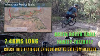
trail: Wirrabara Forest Trail
11:57 |
303 |
Apr 28, 2023 , whyalla
Recent Trail Reports
| status | trail | date | condition | info | user |
|---|---|---|---|---|---|
| Wirrabara Forest Trail | Aug 12, 2025 @ 8:55pm Aug 12, 2025 | Unknown | TyronRobinson1 | ||
| Bridle Track | Apr 30, 2023 @ 2:54am Apr 30, 2023 | Variable | Gill123 | ||
| Rocky River Rail Trail | Apr 30, 2021 @ 3:33pm Apr 30, 2021 | Ideal | Adelaidebikergirl | ||
| Dogs Breakfast | Jul 24, 2020 @ 11:20pm Jul 24, 2020 | Dry | Slothman71 | ||
| Haydn's Drop 2019 | Jul 24, 2020 @ 11:20pm Jul 24, 2020 | Dry | Slothman71 | ||
| Slug Gun Climb | Jul 24, 2020 @ 11:20pm Jul 24, 2020 | Dry | Slothman71 | ||
| Missing Link | Jul 24, 2020 @ 11:20pm Jul 24, 2020 | Dry | Slothman71 | ||
| Redneck Rollerecoaster | Jul 24, 2020 @ 11:20pm Jul 24, 2020 | Dry | Slothman71 | ||
| Leviathan Stage 2 | Jul 24, 2020 @ 11:20pm Jul 24, 2020 | Dry | Slothman71 | ||
| Leviathan Stage 1 | Jul 24, 2020 @ 11:20pm Jul 24, 2020 | Dry | Slothman71 |
Activity Feed
| username | action | type | title | date |
|---|---|---|---|---|
| Adam0ruHs3 | vote | trail | activity #96592795 | Jun 9, 2026 @ 2:48am Jun 9, 2026 |
| GeofrIQKR5 | ridden | trail | activity #91738604 | Apr 1, 2026 @ 6:12pm Apr 1, 2026 |
| Good3OhkY5 | ridden | skillpark | activity #81587232 | Oct 2, 2025 @ 9:34pm Oct 2, 2025 |
| Good3OhkY5 | vote | skillpark | activity #81587231 | Oct 2, 2025 @ 9:34pm Oct 2, 2025 |
| TyronRobinson1 | add | photo | activity #78321545 and 1 more | Aug 17, 2025 @ 4:37am Aug 17, 2025 |
Local Badges
-

Completionist0 awarded -

10 Blue Trails9 awarded -

Epic Mountain Bike Climb 2k0 awarded -

Climbing 10k Badge6 awarded -

Mountain Biking 100k Badge0 awarded -

Epic Ride Descent 2k0 awarded
Bike & Skill Parks
| name | type | city | rating |
|---|---|---|---|
| Whyalla Skate Park | skill park | whyalla | |
| Tumby Bay Pump Track | skill park | whyalla |
Activity Type Stats
| activitytype | trails | distance | descent | descent distance | total vertical | rating | global rank | state rank | photos | reports | routes | ridelogs |
|---|---|---|---|---|---|---|---|---|---|---|---|---|
| Mountain Bike | 67 | 68 miles | 5,210 ft | 28 miles | 1,486 ft | #2,254 | #101 | 63 | 12 | 1 | 4,199 | |
| E-Bike | 38 | 47 miles | 3,842 ft | 21 miles | 1,434 ft | #2,765 | #139 | 12 | 109 | |||
| Horse | 1 | 8 miles | 1,401 ft | 5 miles | 1,362 ft | |||||||
| Hike | 52 | 106 miles | 7,434 ft | 46 miles | 2,274 ft | #2,361 | #69 | 12 | 42 | |||
| Trail Running | 52 | 106 miles | 7,434 ft | 46 miles | 2,274 ft | #1,889 | #53 | 12 | 34 | |||
| Dirtbike/Moto | 1 | 8 miles | 1,401 ft | 5 miles | 1,362 ft | 1 | ||||||
| ATV/ORV/OHV | 1 | 8 miles | 1,401 ft | 5 miles | 1,362 ft |
Frequently Asked Questions About whyalla
▼
What are the best places to ride in whyalla?
whyalla has 1 areas to explore for mountain biking. The top rated areas are:
▼
What are the highest rated mountain biking trails in whyalla?
The highest rated mountain biking trails in whyalla are:
- Wirrabara Forest Trail (4.2/5)
- Haydn's Drop 2019 (4.2/5)
- Markor Parkor (4.1/5)
- Regroove the Shoes (4.1/5)
- Mad Myall (4.1/5)
▼
What is the best time of the year to ride in whyalla?
Based on ride log data, the most popular months to ride in whyalla are:
- May (4 activities)
- August (3 activities)
- June (3 activities)
▼
Where can I park to ride in whyalla?
There are 3 parking locations listed in whyalla. The most popular parking spots are: View all parking and trailhead locations on the map to plan your visit.
Activities
Trails
Points of Interest
- By Fishingmad & contributors
- Admins: NPSA, Coneofsilence
- #24843 - 4,404 views
- whyalla activity log | embed map of whyalla mountain bike trails | whyalla mountain biking points of interest
Downloading of trail gps tracks in kml & gpx formats is enabled for whyalla.
You must login to download files.