close
-
Layers w
- Weather Layers
- Pro
- Pro
- Pro
- Pro
- Pro
- Pro
- More Layers
- Pro
- Pro
- Pro
- Pro
-
Upgrade to

3D
Trail Conditions
- Unknown
- Snow Groomed
- Snow Packed
- Snow Covered
- Snow Cover Partial
- Freeze/thaw Cycle
- Icy
- Prevalent Mud
- Wet
- Variable
- Ideal
- Dry
- Very Dry
Trail Flow (Ridden Direction)
Trailforks scans users ridelogs to determine the most popular direction each trail is ridden. A good flowing trail network will have most trails flowing in a single direction according to their intension.
The colour categories are based on what percentage of riders are riding a trail in its intended direction.
The colour categories are based on what percentage of riders are riding a trail in its intended direction.
- > 96%
- > 90%
- > 80%
- > 70%
- > 50%
- < 50%
- bi-directional trail
- no data
Trail Last Ridden
Trailforks scans ridelogs to determine the last time a trail was ridden.
- < 2 days
- < 1 week
- < 2 weeks
- < 1 month
- < 6 months
- > 6 months
Trail Ridden Direction
The intended direction a trail should be ridden.
- Downhill Only
- Downhill Primary
- Both Directions
- Uphill Primary
- Uphill Only
- One Direction
Contribute Details
Colors indicate trail is missing specified detail.
- Description
- Photos
- Description & Photos
- Videos
Trail Popularity ?
Trailforks scans ridelogs to determine which trails are ridden the most in the last 9 months.
Trails are compared with nearby trails in the same city region with a possible 25 colour shades.
Think of this as a heatmap, more rides = more kinetic energy = warmer colors.
- most popular
- popular
- less popular
- not popular
ATV/ORV/OHV Filter
Max Vehicle Width
inches
US Cell Coverage
Legend

Radar Time
Activity Recordings
Trailforks uses anonymized public activity data.
?
Activity Recordings
Trailforks uses anonymized public activity data.
?
Personal Heatmap
▶
Activity Types
all
/
none
▶
Options
2
Date range
month
–
Winter Trails
Warning
A routing network for winter maps does not exist. Selecting trails using the winter trails layer has been disabled.
Missing Trails
Most Popular
Least Popular
Trails are colored based on popularity. The more popular a trail is, the more red. Less popular trails trend towards green.
Jump Magnitude Heatmap
Heatmap of where riders jump on trails. Zoom in to see individual jumps, click circles to view jump details.
BC Backroad Status
![map legend]()
Service Road Atlas is a free to use, community-driven service for viewing and creating reports on the numerous back-country service roads around B.C. and Alberta.

Slope Aspect
Direction the slope faces
Trails Deemphasized
Trails are shown in grey.
Only show trails with no bike usage.
Suggested Layers
Based on selected activity type
Save the current map location and zoom level as your default home location whenever this page is loaded.
Save
No description for Wiesbaden has been added yet!
Login or register to submit one.
This region uses the Uk/Euro style trail grading system.
Activities Click to view
- Mountain Bike
79 trails
- E-Bike
83 trails
- Gravel Bike
0 trails
- Adaptive Bike
0 trails
- Hike
79 trails
- Trail Running
79 trails
Region Details
- 9
- 22
- 16
- 2
Region Status
Caution as of Jun 13, 2026Stats
- Avg Trail Rating
- Trails (view details)
- 49
- Trails Mountain Bike
- 83
- Trails E-Bike
- 83
- Trails Hike
- 80
- Trails Trail Running
- 79
- Total Distance
- 30 miles
- Total Descent
- 8,807 ft
- Total Vertical
- 1,499 ft
- Highest Trailhead
- 2,031 ft
- Reports
- 195
- Photos
- 87
- Ridden Counter
- 1,696
Popular Wiesbaden Mountain Biking Trails
Gravity Trail Schläferskopf Permanently Closed
• 40 ★ 4.8 • 4,806 ft • 0 ft • 141 •
Rocky powerline trail. The beginning 2 sections are a bit more steep and technical, the rest of the trail gets more mellow and flowy. In general the trail offers a lot of jumps, gaps and drops. Perfect, if you're looking for air time.
• 80 ★ 4.6 • 2 miles • 5 ft • 105 •
Technical singletrack - steep, rocky, and rooted in some areas. A couple small jumps and one gap jump
• 100 ★ 4.6 • 5,010 ft • 0 ft • 86 •
Highly rated popular blue difficulty singletrack. This mountain bike primary trail can be used downhill only. It features berm, drop, jump and roller coaster. On average it takes 6 minutes to complete this trail.
• 60 ★ 5.0 • 673 ft • 7 ft • 71 •
Moderately popular green difficulty singletrack. This multi-use trail can be used both directions. On average it takes 2 minutes to complete this trail.
• 90 ★ 4.8 • 1 mile • 33 ft • 48 •
Fun flowy singletrack through the woods with little berms and a small climb in the middle
• 95 ★ 3.0 • 1 mile • 17 ft • 45 •
Popular blue difficulty singletrack. This mountain bike primary trail. Trail visibility is always easy to follow. On average it takes 6 minutes to complete this trail.
• 85 ★ 4.0 • 2,664 ft • 12 ft • 45 •
Popular blue difficulty singletrack. This mountain bike primary trail. Trail visibility is always easy to follow. On average it takes 8 minutes to complete this trail.
Wiesbaden Mountain Bike Routes
5 miles • 711 ft • 0 • Loop •
Starting at the Nerotalpark the route goes up and down the Neroberg. The climbs are easy fireroads and the...
33 miles • 1,288 ft • 0 • Loop •
Nice route where you can see different things outside the city area
9 miles • 1,109 ft • 0 • Loop •
Short route along nice and easy flowtrails (STS: S0).
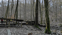
Photos of Wiesbaden Mountain Bike
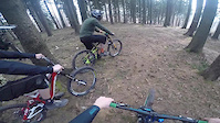
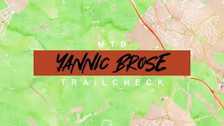
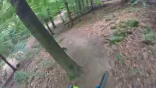
Videos of Wiesbaden Mountain Bike
trail: Gravity Trail Schläferskopf
0:12 |
501 |
Mar 8, 2021
trail: Gravity Trail Schläferskopf
0:41 |
1026 |
Apr 10, 2016
trail: Gravity Trail Schläferskopf
4:37 |
394 |
Aug 2, 2022 , Wiesbaden
trail: Platte Trail Teil 1
2879 |
Nov 22, 2015 , Wiesbaden
Recent Trail Reports
| status | trail | date | condition | info | user |
|---|---|---|---|---|---|
| Gravity Trail Schläferskopf | Jun 13, 2026 @ 2:10pm (Europe/Berlin) Jun 13, 2026 | Unknown | MarcelGIpBc0 | ||
| Hahnberg Up And Down | Jun 3, 2026 @ 3:47pm (Europe/Luxembourg) Jun 3, 2026 | Wet | ChrisTaunus | ||
| Rassel Trail | May 1, 2026 @ 12:19am (Europe/Berlin) Apr 30, 2026 | Ideal | letsgosurfin | ||
| Acht Ecken | May 1, 2026 @ 12:17am (Europe/Berlin) Apr 30, 2026 | Ideal | letsgosurfin | ||
| Platte Trail Alternatives Ende | Feb 15, 2026 @ 12:00pm (Europe/Luxembourg) Feb 15, 2026 | Variable | Aa53qt | ||
| Platte Trail Teil 2 | Feb 15, 2026 @ 12:00pm (Europe/Luxembourg) Feb 15, 2026 | Variable | Aa53qt | ||
| Goldstein Zugang | Feb 15, 2026 @ 12:00pm (Europe/Luxembourg) Feb 15, 2026 | Wet | Aa53qt | ||
| Platte Trail Teil 1 | Feb 15, 2026 @ 12:00pm (Europe/Luxembourg) Feb 15, 2026 | Variable | Aa53qt | ||
| Gold Rausch Upper | Feb 15, 2026 @ 12:00pm (Europe/Luxembourg) Feb 15, 2026 | Variable | Aa53qt | ||
| Wehener Wand DH (upper) | Feb 15, 2026 @ 12:00pm (Europe/Luxembourg) Feb 15, 2026 | Variable | Aa53qt |
Activity Feed
| username | action | type | title | date |
|---|---|---|---|---|
| MarcelGIpBc0 | comment | trail | activity #96864769 | Jun 13, 2026 @ 5:13am Jun 13, 2026 |
| MarcelGIpBc0 | add | report | activity #96864553 | Jun 13, 2026 @ 5:10am Jun 13, 2026 |
| ChrisTaunus | add | report | activity #96167467 | Jun 3, 2026 @ 10:55am Jun 3, 2026 |
| mtjbjet | ridden | trail | activity #95398684 | May 24, 2026 @ 5:18am May 24, 2026 |
| mtjbjet | add | photo | activity #95398619 | May 24, 2026 @ 5:17am May 24, 2026 |
Recent Comments
| username | type | title | comment | date |
|---|---|---|---|---|
| trail | Trail is inofficially usable again especially... | Jun 13, 2026 @ 5:13am Jun 13, 2026 | ||
| trail | Ignore the signs that say mountain biking is... | Jul 14, 2024 @ 10:13pm Jul 14, 2024 | ||
| trail | Nicht mehr befahrbar! | May 21, 2024 @ 1:44am May 21, 2024 | ||
| trail | It was closed 1,5 year ago. I hoped that for... | Sep 16, 2023 @ 6:07am Sep 16, 2023 | ||
| trail | Is not closed, rode today. | Sep 16, 2023 @ 3:54am Sep 16, 2023 |
Local Badges
-

Epic Ride Climb 2k53 awarded -

Climbing 10k Badge39 awarded -

Climbing 100k Badge2 awarded -

Epic Ride Descent 2k53 awarded -

Descent 10k Badge40 awarded -

Descent 100k Badge2 awarded
Activity Type Stats
| activitytype | trails | distance | descent | descent distance | total vertical | rating | global rank | state rank | photos | reports | routes | ridelogs |
|---|---|---|---|---|---|---|---|---|---|---|---|---|
| Mountain Bike | 79 | 30 miles | 8,806 ft | 18 miles | 1,499 ft | #2,713 | #27 | 87 | 204 | 3 | 5,848 | |
| E-Bike | 83 | 30 miles | 8,806 ft | 18 miles | 1,499 ft | #2,168 | #36 | 172 | 1 | 1,579 | ||
| Hike | 79 | 23 miles | 5,561 ft | 12 miles | 1,381 ft | #3,837 | #30 | 183 | 1 | 236 | ||
| Trail Running | 79 | 22 miles | 5,272 ft | 11 miles | 1,381 ft | #3,401 | #29 | 183 | 1 | 51 |
Frequently Asked Questions About Wiesbaden
▼
What are the best places to ride in Wiesbaden?
▼
What are the highest rated mountain biking trails in Wiesbaden?
The highest rated mountain biking trails in Wiesbaden are:
- Platte Trail Teil 1 (4.3/5)
- Acht Ecken (4.3/5)
- Rassel Trail (4.3/5)
- Goldstein (4.3/5)
- Idstein (4.1/5)
▼
What is the best time of the year to ride in Wiesbaden?
Based on ride log data, the most popular months to ride in Wiesbaden are:
- June (46 activities)
- April (42 activities)
- May (36 activities)
▼
Where can I park to ride in Wiesbaden?
There are 3 parking locations listed in Wiesbaden. The most popular parking spots are: View all parking and trailhead locations on the map to plan your visit.
Activities
Trails
Points of Interest
- By bikrboy38 & contributors
- Admins: HDRiders, sp00n82
- #9439 - 12,004 views
- wiesbaden activity log | embed map of Wiesbaden mountain bike trails | wiesbaden mountain biking points of interest
Downloading of trail gps tracks in kml & gpx formats is enabled for Wiesbaden.
You must login to download files.