close
-
Layers w
- Weather Layers
- Pro
- Pro
- Pro
- Pro
- Pro
- Pro
- More Layers
- Pro
- Pro
- Pro
- Pro
-
Upgrade to

3D
Trail Conditions
- Unknown
- Snow Groomed
- Snow Packed
- Snow Covered
- Snow Cover Partial
- Freeze/thaw Cycle
- Icy
- Prevalent Mud
- Wet
- Variable
- Ideal
- Dry
- Very Dry
Trail Flow (Ridden Direction)
Trailforks scans users ridelogs to determine the most popular direction each trail is ridden. A good flowing trail network will have most trails flowing in a single direction according to their intension.
The colour categories are based on what percentage of riders are riding a trail in its intended direction.
The colour categories are based on what percentage of riders are riding a trail in its intended direction.
- > 96%
- > 90%
- > 80%
- > 70%
- > 50%
- < 50%
- bi-directional trail
- no data
Trail Last Ridden
Trailforks scans ridelogs to determine the last time a trail was ridden.
- < 2 days
- < 1 week
- < 2 weeks
- < 1 month
- < 6 months
- > 6 months
Trail Ridden Direction
The intended direction a trail should be ridden.
- Downhill Only
- Downhill Primary
- Both Directions
- Uphill Primary
- Uphill Only
- One Direction
Contribute Details
Colors indicate trail is missing specified detail.
- Description
- Photos
- Description & Photos
- Videos
Trail Popularity ?
Trailforks scans ridelogs to determine which trails are ridden the most in the last 9 months.
Trails are compared with nearby trails in the same city region with a possible 25 colour shades.
Think of this as a heatmap, more rides = more kinetic energy = warmer colors.
- most popular
- popular
- less popular
- not popular
ATV/ORV/OHV Filter
Max Vehicle Width
inches
US Cell Coverage
Legend

Radar Time
Activity Recordings
Trailforks uses anonymized public activity data.
?
Activity Recordings
Trailforks uses anonymized public activity data.
?
Personal Heatmap
▶
Activity Types
all
/
none
▶
Options
2
Date range
month
–
Winter Trails
Warning
A routing network for winter maps does not exist. Selecting trails using the winter trails layer has been disabled.
Missing Trails
Most Popular
Least Popular
Trails are colored based on popularity. The more popular a trail is, the more red. Less popular trails trend towards green.
Jump Magnitude Heatmap
Heatmap of where riders jump on trails. Zoom in to see individual jumps, click circles to view jump details.
BC Backroad Status
![map legend]()
Service Road Atlas is a free to use, community-driven service for viewing and creating reports on the numerous back-country service roads around B.C. and Alberta.

Slope Aspect
Direction the slope faces
Trails Deemphasized
Trails are shown in grey.
Only show trails with no bike usage.
Suggested Layers
Based on selected activity type
Save the current map location and zoom level as your default home location whenever this page is loaded.
Save
No description for Wilkowice has been added yet!
Login or register to submit one.
This region uses the Uk/Euro style trail grading system.
Activities Click to view
- Mountain Bike
34 trails
- E-Bike
17 trails
- Gravel Bike
0 trails
- Adaptive Bike
- Winter Fat Bike
0 trails
- Horse
0 trails
- Hike
23 trails
- Trail Running
23 trails
- Observed Trials
0 trails
- Snowshoe
4 trails
- Downhill Ski
3 trails
- Backcountry Ski
8 trails
- Nordic Ski
5 trails
Region Details
- 22
- 1
- 1
- 6
- 3
Region Status
Open as of Nov 28, 2025Stats
- Avg Trail Rating
- Trails (view details)
- 34
- Trails Mountain Bike
- 34
- Trails E-Bike
- 17
- Trails Hike
- 23
- Trails Trail Running
- 23
- Trails Snowshoe
- 4
- Trails Downhill Ski
- 3
- Trails Backcountry Ski
- 8
- Trails Nordic Ski
- 5
- Total Distance
- 38 miles
- Total Descent
- 10,178 ft
- Total Vertical
- 2,445 ft
- Highest Trailhead
- 3,633 ft
- Reports
- 637
- Photos
- 277
- Ridden Counter
- 2,835
Sub Regions
-
Magurka Wilkowicka
- 1
- 2
Popular Wilkowice Mountain Biking Trails
• 100 ★ 5.0 • 545 ft • 0 ft • 164 •
Krótki ale bardzo treściwy singletrack specjalnie dla dzieci. Kilka zakrętów i lekkich band a pomiędzy nimi małe, szerokie mostki. Ścieżka jest w pełni legalna.
• 90 ★ 5.0 • 4,780 ft • 0 ft • 92 •
Popular red difficulty singletrack. This mountain bike primary trail can be used downhill only. Trail visibility is always easy to follow. On average it takes 20 minutes to complete this trail.
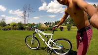
Photos of Wilkowice Mountain Bike
Videos of Wilkowice Mountain Bike
trail: Bystry
4:35 |
7 |
Jul 14, 2014
trail: Magura
0:23 |
702 |
Nov 13, 2011

trail: .buMer
3:58 |
274 |
Apr 5, 2024 , Wilkowice
trail: Magura
0:45 |
656 |
Apr 4, 2011
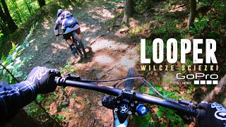
trail: Looper Access
16:39 |
350 |
Jul 31, 2019 , Wilkowice
Recent Trail Reports
| status | trail | date | condition | info | user |
|---|---|---|---|---|---|
| .buMer | Nov 28, 2025 @ 12:25pm (Europe/Warsaw) Nov 28, 2025 | Snow Cover Partial | Spaff | ||
| Trawers Górskiej | Oct 4, 2025 @ 11:17am (Europe/Bratislava) Oct 4, 2025 | Variable | slavio | ||
| Looper Access | Oct 4, 2025 @ 11:17am (Europe/Bratislava) Oct 4, 2025 | Variable | slavio | ||
| Magura | Sep 28, 2025 @ 10:19pm (Europe/Warsaw) Sep 28, 2025 | Ideal | r85 | ||
| Do Czerwonego | Sep 21, 2025 @ 9:44am (Europe/Bratislava) Sep 21, 2025 | Ideal | Jarek09 GANDI | ||
| Do Borówy Szeroko | Jul 31, 2025 @ 1:05pm Jul 31, 2025 | Ideal | Spaff | ||
| Harcerska | Jul 31, 2025 @ 1:05pm Jul 31, 2025 | Ideal | Spaff | ||
| Bystra - Klimczok Schronisko | Jul 21, 2025 @ 12:50am Jul 21, 2025 | Dry | EnduroDlaPoczatkujacych | ||
| Basior | Jul 5, 2025 @ 9:03am Jul 5, 2025 | Variable | enforce | ||
| Kubuś | Nov 17, 2024 @ 9:38am Nov 17, 2024 | Ideal | Jarek09 GANDI |
Activity Feed
| username | action | type | title | date |
|---|---|---|---|---|
| MateuszPoFWFk | wishlist | trail | activity #94744817 | May 15, 2026 @ 5:50am May 15, 2026 |
| Spaff | add | report | activity #84858849 | Nov 28, 2025 @ 11:31am Nov 28, 2025 |
| ASleep6w6EyO | wishlist | trail | activity #83131139 | Oct 27, 2025 @ 2:15pm Oct 27, 2025 |
| slavio | add | report | activity #81668814 and 1 more | Oct 4, 2025 @ 7:10am Oct 4, 2025 |
| betoniarka | wishlist | trail | activity #81648751 | Oct 3, 2025 @ 10:04pm Oct 3, 2025 |
Recent Comments
| username | type | title | comment | date |
|---|---|---|---|---|
| trail | Mega fajna trasa. Praktycznie jedziemy po... | Jul 18, 2025 @ 5:46am Jul 18, 2025 |
Local Badges
-

Epic Mountain Bike Climb 2k1 awarded -

Climbing 10k Badge4 awarded -

Mountain Biking 100k Badge0 awarded -

Epic Ride Descent 2k1 awarded -

Descent 10k Badge4 awarded -

Descent 100k Badge0 awarded
Activity Type Stats
| activitytype | trails | distance | descent | descent distance | total vertical | rating | global rank | state rank | photos | reports | routes | ridelogs |
|---|---|---|---|---|---|---|---|---|---|---|---|---|
| Mountain Bike | 34 | 36 miles | 9,790 ft | 14 miles | 2,444 ft | #2,228 | #37 | 275 | 637 | 6,776 | ||
| E-Bike | 17 | 22 miles | 3,684 ft | 6 miles | 2,277 ft | #3,588 | #320 | 2 | 547 | 1,912 | ||
| Hike | 23 | 30 miles | 4,052 ft | 7 miles | 2,444 ft | #5,458 | #100 | 510 | 681 | |||
| Trail Running | 23 | 30 miles | 4,052 ft | 7 miles | 2,444 ft | #5,399 | #104 | 510 | 88 | |||
| Snowshoe | 4 | 1 mile | 95 ft | 2,392 ft | 696 ft | #587 | #37 | 2 | ||||
| Downhill Ski | 3 | 1,909 ft | 26 ft | 636 ft | 46 ft | #548 | #35 | 5 | ||||
| Backcountry Ski | 8 | 10 miles | 1,463 ft | 3 miles | 1,896 ft | #456 | #48 | 4 | 6 | |||
| Nordic Ski | 5 | 5 miles | 548 ft | 1 mile | 1,407 ft | #881 | #48 | 53 |
Frequently Asked Questions About Wilkowice
▼
What are the best places to ride in Wilkowice?
Wilkowice has 2 areas to explore for mountain biking. The top rated areas are:
▼
What are the highest rated mountain biking trails in Wilkowice?
The highest rated mountain biking trails in Wilkowice are: View all mountain biking trails sorted by rating.
▼
What is the best time of the year to ride in Wilkowice?
Based on ride log data, the most popular months to ride in Wilkowice are:
- June (27 activities)
- August (27 activities)
- May (23 activities)
▼
Where can I park to ride in Wilkowice?
There are 1 parking locations listed in Wilkowice. The most popular parking spots are:
Activities
Trails
Points of Interest
- wilkowice activity log | embed map of Wilkowice mountain bike trails | wilkowice mountain biking points of interest
Downloading of trail gps tracks in kml & gpx formats is enabled for Wilkowice.
You must login to download files.