close
-
Layers w
- Weather Layers
- Pro
- Pro
- Pro
- Pro
- Pro
- Pro
- More Layers
- Pro
- Pro
- Pro
- Pro
-
Upgrade to

3D
Trail Conditions
- Unknown
- Snow Groomed
- Snow Packed
- Snow Covered
- Snow Cover Partial
- Freeze/thaw Cycle
- Icy
- Prevalent Mud
- Wet
- Variable
- Ideal
- Dry
- Very Dry
Trail Flow (Ridden Direction)
Trailforks scans users ridelogs to determine the most popular direction each trail is ridden. A good flowing trail network will have most trails flowing in a single direction according to their intension.
The colour categories are based on what percentage of riders are riding a trail in its intended direction.
The colour categories are based on what percentage of riders are riding a trail in its intended direction.
- > 96%
- > 90%
- > 80%
- > 70%
- > 50%
- < 50%
- bi-directional trail
- no data
Trail Last Ridden
Trailforks scans ridelogs to determine the last time a trail was ridden.
- < 2 days
- < 1 week
- < 2 weeks
- < 1 month
- < 6 months
- > 6 months
Trail Ridden Direction
The intended direction a trail should be ridden.
- Downhill Only
- Downhill Primary
- Both Directions
- Uphill Primary
- Uphill Only
- One Direction
Contribute Details
Colors indicate trail is missing specified detail.
- Description
- Photos
- Description & Photos
- Videos
Trail Popularity ?
Trailforks scans ridelogs to determine which trails are ridden the most in the last 9 months.
Trails are compared with nearby trails in the same city region with a possible 25 colour shades.
Think of this as a heatmap, more rides = more kinetic energy = warmer colors.
- most popular
- popular
- less popular
- not popular
ATV/ORV/OHV Filter
Max Vehicle Width
inches
US Cell Coverage
Legend

Radar Time
Activity Recordings
Trailforks uses anonymized public activity data.
?
Activity Recordings
Trailforks uses anonymized public activity data.
?
Personal Heatmap
▶
Activity Types
all
/
none
▶
Options
2
Date range
month
–
Winter Trails
Warning
A routing network for winter maps does not exist. Selecting trails using the winter trails layer has been disabled.
Missing Trails
Most Popular
Least Popular
Trails are colored based on popularity. The more popular a trail is, the more red. Less popular trails trend towards green.
Jump Magnitude Heatmap
Heatmap of where riders jump on trails. Zoom in to see individual jumps, click circles to view jump details.
BC Backroad Status
![map legend]()
Service Road Atlas is a free to use, community-driven service for viewing and creating reports on the numerous back-country service roads around B.C. and Alberta.

Slope Aspect
Direction the slope faces
Trails Deemphasized
Trails are shown in grey.
Only show trails with no bike usage.
Suggested Layers
Based on selected activity type
Save the current map location and zoom level as your default home location whenever this page is loaded.
Save
No description for Willingen has been added yet!
Login or register to submit one.
This region uses the Uk/Euro style trail grading system.
Activities Click to view
- Mountain Bike
18 trails
- E-Bike
17 trails
- Adaptive Bike
0 trails
- Winter Fat Bike
0 trails
- Hike
12 trails
- Trail Running
12 trails
Region Details
- 3
- 5
- 4
- 6
Region Status
Caution as of 2 daysStats
- Avg Trail Rating
- Trails (view details)
- 18
- Trails Mountain Bike
- 18
- Trails E-Bike
- 17
- Trails Hike
- 12
- Trails Trail Running
- 12
- Trails Nordic Ski
- 3
- Total Distance
- 8 miles
- Total Descent
- 5,204 ft
- Total Vertical
- 1,064 ft
- Highest Trailhead
- 2,766 ft
- Reports
- 270
- Photos
- 91
- Ridden Counter
- 11,326
Articles
Video: Celebrating the End of Lockdown by Hitting the Bike Park
Aug 13, 2020 from pinkbike.com
Oli Dorn hits the bike park but Balu the pup has to stay home this time.
Popular Willingen Mountain Biking Trails
• 100 ★ 3.8 • 3,451 ft • 9 ft • 1,061 •
last part of all Willingen bike routes.
• 85 ★ 3.7 • 4,675 ft • 0 ft • 1,059 •
Die fährt sich flowig und feinsten Fahrspaß. Sie hat größere Sprünge als die Flow Trails und ist darum anspruchsvoller zu fahren. Anliegerkurven, Tables und weitere Elemente bilden den typischen Charakter. Alle Sprünge sind...
• 95 ★ 4.5 • 1 mile • 3 ft • 1,026 •
"Flüssig zu fahren, wie von selbst – das ist der Flow Country Trail. Durch die spezielle Streckenkonstruktion und die Kombination von Wellen und Kurven erlebst du das typisch flowige, euphorisierende Fahrgefühl wie bei einer...
• 90 ★ 3.5 • 1 mile • 7 ft • 989 •
"Die besondere Streckenführung ermöglicht besonders flüssiges Fahren. Ohne viel Anstrengung, fast wie von selbst rollst du durch Steilkurven, über kleine Wellen. Kleinere Sprünge sind rollbar. Die Strecke ist familiengerecht und...
• 75 ★ 4.7 • 4,547 ft • 3 ft • 781 •
"Die naturbelassene Strecke ist die finale Stage der Deutschen Meisterschaft. Sie führt neben den Flow Trails auf der linken Seite des Ettelsbergs hinab. Weichem Waldboden, Wurzeln, Steine und Spitzkehren sind die typischen Elemente...
• 80 ★ 4.0 • 4,216 ft • 0 ft • 699 •
https://www.mtbzone-bikepark.com/willingen/strecken/downhill/
• 100 ★ 4.0 • 1,161 ft • 3 ft • 449 •
Trail with a choice of drops and some table jumps.
• 55 ★ 2.4 • 1,118 ft • 0 ft • 429 •
Moderately popular green difficulty gravel path. This mountain bike primary trail can be used downhill primary and has a easy overall physical rating. It features pump track. On average it takes minutes to complete this trail.
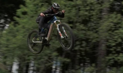
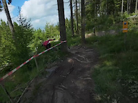
Photos of Willingen Mountain Bike
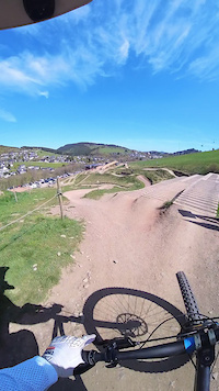
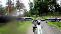
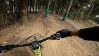
Videos of Willingen Mountain Bike
trail: Willingen Downhill
0:05 |
2 |
Jun 13, 2026
trail: Freeride
0:20 |
100 |
Apr 29, 2026
trail: Freeride
0:10 |
46 |
Jun 8, 2025
trail: Freeride
0:07 |
46 |
Jun 24, 2024
trail: Willingen Downhill
0:09 |
85 |
Sep 7, 2022
trail: Willingen Downhill
0:18 |
109 |
Mar 11, 2022
trail: Willingen Downhill
0:11 |
68 |
Jun 7, 2021

trail: Freeride
0:40 |
24 |
Jan 21, 2021
Recent Trail Reports
| status | trail | date | condition | info | user |
|---|---|---|---|---|---|
| Pump Track | Jun 18, 2026 @ 10:46am (Europe/Berlin) 2 days | Dry | Karstenbay | ||
| Freeride Lower | Jun 18, 2026 @ 10:46am (Europe/Berlin) 2 days | Dry | Karstenbay | ||
| Ettelsberg Green | Jun 18, 2026 @ 10:46am (Europe/Berlin) 2 days | Ideal | Karstenbay | ||
| Enduro-Line | Oct 12, 2025 @ 10:04am (Europe/Luxembourg) Oct 12, 2025 | Wet | LouisCifer | ||
| Freeride | Oct 12, 2025 @ 10:04am (Europe/Luxembourg) Oct 12, 2025 | Variable | LouisCifer | ||
| Flowtrail | Oct 12, 2025 @ 10:04am (Europe/Luxembourg) Oct 12, 2025 | Ideal | LouisCifer | ||
| Flow Country Trail | Sep 30, 2025 @ 1:34pm (Europe/Luxembourg) Sep 30, 2025 | Ideal | cyper85 | ||
| All trails last part | Sep 30, 2025 @ 1:34pm (Europe/Luxembourg) Sep 30, 2025 | Ideal | cyper85 | ||
| K1 Sesselbahn | Sep 30, 2025 @ 1:34pm (Europe/Luxembourg) Sep 30, 2025 | Ideal | cyper85 | ||
| connection upper part | Sep 10, 2025 @ 2:27pm Sep 10, 2025 | Ideal | sinmki |
Activity Feed
| username | action | type | title | date |
|---|---|---|---|---|
| Karstenbay | add | report | activity #97267653 and 2 more | Jun 18, 2026 @ 11:58am 2 days |
| 38x10 | add | photo | activity #96211415 | Jun 4, 2026 @ 1:44am Jun 4, 2026 |
| Roy-w | ridden | trail | activity #95501195 and 7 more | May 25, 2026 @ 10:22am May 25, 2026 |
| Peppi1337 | wishlist | trail | activity #95406007 | May 24, 2026 @ 7:07am May 24, 2026 |
| chrissCEIaU | wishlist | trail | activity #95356928 | May 23, 2026 @ 2:47pm May 23, 2026 |
Recent Comments
| username | type | title | comment | date |
|---|---|---|---|---|
| trail | Pushing double black. Rough and tough | Oct 21, 2021 @ 3:52pm Oct 21, 2021 | ||
| trail | That is a World cup line not a baby line | Oct 10, 2018 @ 6:45am Oct 10, 2018 |
Local Badges
-

Epic Ride Climb 2k636 awarded -

Climbing 10k Badge78 awarded -

Climbing 100k Badge1 awarded -

Epic Ride Descent 2k637 awarded -

Descent 10k Badge141 awarded -

Descent 100k Badge1 awarded
Activity Type Stats
| activitytype | trails | distance | descent | descent distance | total vertical | rating | global rank | state rank | photos | reports | routes | ridelogs |
|---|---|---|---|---|---|---|---|---|---|---|---|---|
| Mountain Bike | 18 | 8 miles | 5,203 ft | 7 miles | 1,063 ft | #1,699 | #17 | 91 | 270 | 4,974 | ||
| E-Bike | 17 | 8 miles | 5,203 ft | 7 miles | 1,063 ft | #3,721 | #92 | 253 | 450 | |||
| Hike | 12 | 4 miles | 2,802 ft | 3 miles | 1,033 ft | #6,569 | #88 | 258 | 158 | |||
| Trail Running | 12 | 4 miles | 2,802 ft | 3 miles | 1,033 ft | #6,041 | #81 | 262 | 15 | |||
| Nordic Ski | 3 | 2 |
Frequently Asked Questions About Willingen
▼
What are the highest rated mountain biking trails in Willingen?
The highest rated mountain biking trails in Willingen are:
- Enduro-Line (4.4/5)
- Flow Country Trail (4.3/5)
- Willingen Downhill (4/5)
- Langenberg DH (4/5)
- Mühlenkopf DH (4/5)
▼
What is the best time of the year to ride in Willingen?
Based on ride log data, the most popular months to ride in Willingen are:
- August (34 activities)
- July (32 activities)
- June (27 activities)
▼
Where can I park to ride in Willingen?
Check the Willingen trail map for trailhead and parking information. Community members regularly update access and parking details for trails in the area.
▼
What is the longest trail in Willingen?
The longest trail in Willingen is Ettelsberg Green at 4.4 km. View all trails sorted by distance.
Activities
Trails
Points of Interest
- By slackliner & contributors
- Admins: HDRiders, sp00n82
- #5680 - 8,182 views
- willingen activity log | embed map of Willingen mountain bike trails |
Downloading of trail gps tracks in kml & gpx formats is enabled for Willingen.
You must login to download files.