close
-
Layers w
- Weather Layers
- Pro
- Pro
- Pro
- Pro
- Pro
- Pro
- More Layers
- Pro
- Pro
- Pro
- Pro
-
Upgrade to

3D
Trail Conditions
- Unknown
- Snow Groomed
- Snow Packed
- Snow Covered
- Snow Cover Partial
- Freeze/thaw Cycle
- Icy
- Prevalent Mud
- Wet
- Variable
- Ideal
- Dry
- Very Dry
Trail Flow (Ridden Direction)
Trailforks scans users ridelogs to determine the most popular direction each trail is ridden. A good flowing trail network will have most trails flowing in a single direction according to their intension.
The colour categories are based on what percentage of riders are riding a trail in its intended direction.
The colour categories are based on what percentage of riders are riding a trail in its intended direction.
- > 96%
- > 90%
- > 80%
- > 70%
- > 50%
- < 50%
- bi-directional trail
- no data
Trail Last Ridden
Trailforks scans ridelogs to determine the last time a trail was ridden.
- < 2 days
- < 1 week
- < 2 weeks
- < 1 month
- < 6 months
- > 6 months
Trail Ridden Direction
The intended direction a trail should be ridden.
- Downhill Only
- Downhill Primary
- Both Directions
- Uphill Primary
- Uphill Only
- One Direction
Contribute Details
Colors indicate trail is missing specified detail.
- Description
- Photos
- Description & Photos
- Videos
Trail Popularity ?
Trailforks scans ridelogs to determine which trails are ridden the most in the last 9 months.
Trails are compared with nearby trails in the same city region with a possible 25 colour shades.
Think of this as a heatmap, more rides = more kinetic energy = warmer colors.
- most popular
- popular
- less popular
- not popular
ATV/ORV/OHV Filter
Max Vehicle Width
inches
US Cell Coverage
Legend

Radar Time
Activity Recordings
Trailforks uses anonymized public activity data.
?
Activity Recordings
Trailforks uses anonymized public activity data.
?
Personal Heatmap
▶
Activity Types
all
/
none
▶
Options
2
Date range
month
–
Winter Trails
Warning
A routing network for winter maps does not exist. Selecting trails using the winter trails layer has been disabled.
Missing Trails
Most Popular
Least Popular
Trails are colored based on popularity. The more popular a trail is, the more red. Less popular trails trend towards green.
Jump Magnitude Heatmap
Heatmap of where riders jump on trails. Zoom in to see individual jumps, click circles to view jump details.
BC Backroad Status
![map legend]()
Service Road Atlas is a free to use, community-driven service for viewing and creating reports on the numerous back-country service roads around B.C. and Alberta.

Slope Aspect
Direction the slope faces
Trails Deemphasized
Trails are shown in grey.
Only show trails with no bike usage.
Suggested Layers
Based on selected activity type
Save the current map location and zoom level as your default home location whenever this page is loaded.
Save
No description for Windham has been added yet!
Login or register to submit one.
Activities Click to view
- Mountain Bike
48 trails
- E-Bike
1 trails
- Gravel Bike
0 trails
- Adaptive Bike
0 trails
- Hike
38 trails
- Trail Running
38 trails
- Downhill Ski
57 trails
- Nordic Ski
18 trails
Region Details
- 5
- 10
- 27
- 4
- 1
Region Status
Open as of May 31, 2026Stats
- Avg Trail Rating
- Trails (view details)
- 95
- Trails Mountain Bike
- 48
- Trails E-Bike
- 1
- Trails Hike
- 38
- Trails Trail Running
- 38
- Trails Snowshoe
- 1
- Trails Downhill Ski
- 58
- Trails Nordic Ski
- 18
- Total Distance
- 56 miles
- Total Descent
- 25,400 ft
- Total Vertical
- 1,515 ft
- Highest Trailhead
- 3,093 ft
- Reports
- 1,362
- Photos
- 1,593
- Ridden Counter
- 18,700
Sub Regions
-
Elm Ridge Wild Forest
- 8
- 20
- 1
-
The Windham Path
- 1
-
Windham Mountain Bike Park
- 1
- 5
- 3
- 1
Popular Windham Mountain Biking Trails
• 85 ★ 3.4 • 5,240 ft • 27 ft • 794 •
Popular blue difficulty singletrack. This multi-use trail can be used both directions and has a moderate overall physical rating with a 27 ft green climb. It features rock garden. On average it takes 8 minutes to complete this trail.
• 100 ★ 4.9 • 4,452 ft • 150 ft • 781 •
This trail was completed in Fall 2016 and really showcases some impressive trail building skills. The trail includes a few bridges, many pump track feel sections, lots of berms and an easy climb for all levels. It's a very scenic trail...
• 100 ★ 4.4 • 4,649 ft • 114 ft • 769 •
Great down. Lots of fun trail features. Good flow and can be fast.
• 85 ★ 4.6 • 1 mile • 82 ft • 743 •
Popular blue difficulty singletrack. This multi-use trail can be used both directions and has a moderate overall physical rating with a 82 ft blue climb. On average it takes 13 minutes to complete this trail.
• 60 ★ 4.0 • 1 mile • 548 ft • 684 •
Moderately popular blue difficulty singletrack. This multi-use trail can be used both directions. It features drop and rock garden. On average it takes 21 minutes to complete this trail.
• 95 ★ 4.3 • 1 mile • 23 ft • 669 •
Highly rated popular blue difficulty singletrack. This multi-use trail can be used both directions and has a moderate overall physical rating with a 23 ft blue climb. On average it takes 10 minutes to complete this trail.
• 95 ★ 4.0 • 3,681 ft • 121 ft • 633 •
Popular blue difficulty singletrack. This multi-use trail can be used both directions and has a easy overall physical rating with a 121 ft green climb. It features rock garden. On average it takes 9 minutes to complete this trail.
Windham Mountain Bike Routes
★ 3.8 • 9 miles • 1,174 ft • 15 • Loop •
This route gives you 3 fast down hill runs, with a minimal amount of climbing. Climb Fun Loop to Trail 6...
★ 5.0 • 11 miles • 1,501 ft • 12 • Loop •
This starts with the original "most down, with the least up" route and adds some extra single track at the...
★ 3.5 • 7 miles • 717 ft • 7 •
This is a great 6.8 mile route to hit nearly all of the lower green trails at in an hour or so. It's a...
★ 5.0 • 3,110 ft • 40 ft • 5 • Point to Point •
Bermed Downhill Connecting Berm Out to Field Me
★ 4.0 • 13 miles • 1,526 ft • 17 • Loop •
Two different kind of downhills. 4 miles starting at Midway through Goldmine and then loop around Fun...
★ 5.0 • 9 miles • 900 ft • 7 •
This is The Green Dream route adding the warmup loop.
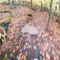
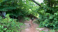
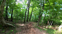
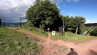
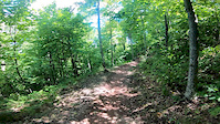
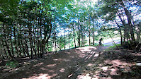
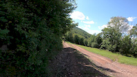
Photos of Windham Mountain Bike
Videos of Windham Mountain Bike
trail: Batavia Skill
0:11 |
146 |
Jun 9, 2021
trail: Citizen's Downhill
0:23 |
117 |
Sep 23, 2020
trail: Citizen's Downhill
0:16 |
41 |
Sep 23, 2020
trail: Citizen's Downhill
0:23 |
58 |
Sep 23, 2020
trail: Batavia Skill
0:17 |
104 |
Sep 23, 2020
trail: Anthill
0:25 |
58 |
Sep 23, 2020
trail: Anthill
0:16 |
36 |
Sep 23, 2020

trail: Citizen's Downhill
5:07 |
159 |
Dec 16, 2019
Current Trail Warnings
| status | trail | date | condition | user | info |
|---|---|---|---|---|---|
| West Gauntlet Trail | May 31, 2026 @ 2:34pm (America/New_York) May 31, 2026 | Unknown | smaggio13 | Tree Down |
Recent Trail Reports
| status | trail | date | condition | info | user |
|---|---|---|---|---|---|
| Pelham Road | May 12, 2026 @ 10:07am (America/New_York) May 12, 2026 | Ideal | Tcraiglinz FCTPT | ||
| North Face | May 12, 2026 @ 10:07am (America/New_York) May 12, 2026 | Ideal | Tcraiglinz FCTPT | ||
| Run Noot | May 12, 2026 @ 10:07am (America/New_York) May 12, 2026 | Ideal | Tcraiglinz FCTPT | ||
| Black Bear Hideout Trail | May 12, 2026 @ 10:07am (America/New_York) May 12, 2026 | Ideal | Tcraiglinz FCTPT | ||
| The Bee | May 12, 2026 @ 10:07am (America/New_York) May 12, 2026 | Ideal | Tcraiglinz FCTPT | ||
| Lollipop | May 12, 2026 @ 10:07am (America/New_York) May 12, 2026 | Ideal | Tcraiglinz FCTPT | ||
| East Gauntlet | May 12, 2026 @ 10:07am (America/New_York) May 12, 2026 | Ideal | Tcraiglinz FCTPT | ||
| Mid Mountain Trail | May 12, 2026 @ 10:07am (America/New_York) May 12, 2026 | Ideal | Tcraiglinz FCTPT | ||
| Big T Trail | May 12, 2026 @ 10:07am (America/New_York) May 12, 2026 | Ideal | Tcraiglinz FCTPT | ||
| Uphill | May 12, 2026 @ 10:07am (America/New_York) May 12, 2026 | Ideal | Tcraiglinz FCTPT |
Activity Feed
| username | action | type | title | date |
|---|---|---|---|---|
| 1Pipepipe | wishlist | region | activity #97192550 | Jun 17, 2026 @ 10:06am 1 day |
| MelanieWetmore8Km | wishlist | route | activity #96413553 | Jun 6, 2026 @ 4:09pm Jun 6, 2026 |
| bananamanjelly | wishlist | trail | activity #96202351 and 4 more | Jun 3, 2026 @ 7:55pm Jun 3, 2026 |
| smaggio13 | add | report | activity #95962623 | May 31, 2026 @ 11:34am May 31, 2026 |
| 3VyZLF | wishlist | region | activity #95796454 | May 29, 2026 @ 12:46pm May 29, 2026 |
Recent Comments
| username | type | title | comment | date |
|---|---|---|---|---|
| trail | Trail ends at a dead end so you will have to... | Dec 16, 2025 @ 7:03am Dec 16, 2025 | ||
| trail | Tree down toward top of run noot | Nov 7, 2025 @ 3:15pm Nov 7, 2025 | ||
| trail | Snow-Fatbike- Groomed levitate, plowed north... | Feb 22, 2025 @ 7:02pm Feb 22, 2025 | ||
| trail | Tree down | Mar 3, 2024 @ 8:42am Mar 3, 2024 | ||
| report | Was not dry, not sure why it's showing that. I... | Feb 26, 2024 @ 4:16pm Feb 26, 2024 |
Local Badges
-

10 Green Trails165 awarded -

10 Blue Trails403 awarded -

Epic Ride Climb 2k436 awarded -

Climbing 10k Badge62 awarded -

Climbing 100k Badge0 awarded -

Epic Ride Descent 2k713 awarded
Bike & Skill Parks
| name | type | city | rating |
|---|---|---|---|
| Windham Mountain Bike Park | bike park | Windham | |
| Windham Mountain Resort | bike park | Windham |
Activity Type Stats
| activitytype | trails | distance | descent | descent distance | total vertical | rating | global rank | state rank | photos | reports | routes | ridelogs |
|---|---|---|---|---|---|---|---|---|---|---|---|---|
| Mountain Bike | 48 | 39 miles | 11,686 ft | 25 miles | 1,463 ft | #1,583 | #594 | 1,593 | 1,354 | 10 | 7,721 | |
| E-Bike | 1 | 4,820 ft | 322 ft | 79 ft | #8,311 | #2,524 | 1,143 | 1 | 191 | |||
| Hike | 38 | 26 miles | 3,383 ft | 12 miles | 1,516 ft | #6,091 | #2,135 | 1,343 | 1 | 308 | ||
| Trail Running | 38 | 26 miles | 3,383 ft | 12 miles | 1,516 ft | #5,653 | #1,801 | 1,343 | 155 | |||
| Snowshoe | 1 | 28 | 15 | |||||||||
| Downhill Ski | 57 | 17 miles | 13,704 ft | 16 miles | 1,437 ft | #367 | #146 | 716 | ||||
| Nordic Ski | 18 | 13 miles | 2,073 ft | 8 miles | 666 ft | #626 | #212 | 51 | 16 |
Frequently Asked Questions About Windham
▼
What are the best places to ride in Windham?
Windham has 4 areas to explore for mountain biking. The top rated areas are:
▼
What are the highest rated mountain biking trails in Windham?
The highest rated mountain biking trails in Windham are:
- Wilderness Roll (4.6/5)
- North Face (4.5/5)
- Gold Mine (4.5/5)
- Windham World Cup DH Track (4.4/5)
- Berm-Out (4.3/5)
▼
What is the best time of the year to ride in Windham?
Based on ride log data, the most popular months to ride in Windham are:
- July (204 activities)
- September (181 activities)
- August (168 activities)
▼
Where can I park to ride in Windham?
There are 6 parking locations listed in Windham. The most popular parking spots are: View all parking and trailhead locations on the map to plan your visit.
Activities
Trails
- By brenthillier
 NSMBA TRAILFORKS & contributors
 - Admins: apply
- #4288 - 9,508 views
- windham activity log | embed map of Windham mountain bike trails | windham mountain biking points of interest
Downloading of trail gps tracks in kml & gpx formats is enabled for Windham.
You must login to download files.