close
-
Layers w
- Weather Layers
- Pro
- Pro
- Pro
- Pro
- Pro
- Pro
- More Layers
- Pro
- Pro
- Pro
- Pro
-
Upgrade to

3D
Trail Conditions
- Unknown
- Snow Groomed
- Snow Packed
- Snow Covered
- Snow Cover Partial
- Freeze/thaw Cycle
- Icy
- Prevalent Mud
- Wet
- Variable
- Ideal
- Dry
- Very Dry
Trail Flow (Ridden Direction)
Trailforks scans users ridelogs to determine the most popular direction each trail is ridden. A good flowing trail network will have most trails flowing in a single direction according to their intension.
The colour categories are based on what percentage of riders are riding a trail in its intended direction.
The colour categories are based on what percentage of riders are riding a trail in its intended direction.
- > 96%
- > 90%
- > 80%
- > 70%
- > 50%
- < 50%
- bi-directional trail
- no data
Trail Last Ridden
Trailforks scans ridelogs to determine the last time a trail was ridden.
- < 2 days
- < 1 week
- < 2 weeks
- < 1 month
- < 6 months
- > 6 months
Trail Ridden Direction
The intended direction a trail should be ridden.
- Downhill Only
- Downhill Primary
- Both Directions
- Uphill Primary
- Uphill Only
- One Direction
Contribute Details
Colors indicate trail is missing specified detail.
- Description
- Photos
- Description & Photos
- Videos
Trail Popularity ?
Trailforks scans ridelogs to determine which trails are ridden the most in the last 9 months.
Trails are compared with nearby trails in the same city region with a possible 25 colour shades.
Think of this as a heatmap, more rides = more kinetic energy = warmer colors.
- most popular
- popular
- less popular
- not popular
ATV/ORV/OHV Filter
Max Vehicle Width
inches
US Cell Coverage
Legend

Radar Time
Activity Recordings
Trailforks uses anonymized public activity data.
?
Activity Recordings
Trailforks uses anonymized public activity data.
?
Personal Heatmap
▶
Activity Types
all
/
none
▶
Options
2
Date range
month
–
Winter Trails
Warning
A routing network for winter maps does not exist. Selecting trails using the winter trails layer has been disabled.
Missing Trails
Most Popular
Least Popular
Trails are colored based on popularity. The more popular a trail is, the more red. Less popular trails trend towards green.
Jump Magnitude Heatmap
Heatmap of where riders jump on trails. Zoom in to see individual jumps, click circles to view jump details.
BC Backroad Status
![map legend]()
Service Road Atlas is a free to use, community-driven service for viewing and creating reports on the numerous back-country service roads around B.C. and Alberta.

Slope Aspect
Direction the slope faces
Trails Deemphasized
Trails are shown in grey.
Only show trails with no bike usage.
Suggested Layers
Based on selected activity type
Save the current map location and zoom level as your default home location whenever this page is loaded.
SaveAs one of Staten Island's largest parks, Wolfe's Pond Park wears many different hats. To some, it is a beautiful beach. To others, it is a wildlife and plant preserve. To others, it is a recreation area with space to run, jump, ride and climb. Choose Wolfe's Pond Park, and choose your own adventure
With 12+ miles of trails for hiking, mountain biking and trail running including trails along the beach, numerous creeks and the many ponds there is something for everyone in this gem of a park.
A 20 minute ride on the Staten Island Ferry and a 33 minute train ride on SIRT gets you to the Trail Head at the Princess Bay Train Station! A fun easy scenic and enjoyable commute to the best trails experience in NYC!
When you complete your trail activities be sure to make use of the BBQ area and the beach!
source: Wolfes Pond Park
Primary Trail Type: Cross-Country
Land Status: City Managed
Land Manager: NYC Parks Department
 google parking directions
 Disclaimer:
Ride at your own risk, Hidden Hazards may exist
Activities Click to view
- Mountain Bike
51 trails
- E-Bike
7 trails
- Hike
63 trails
- Trail Running
61 trails
- Snowshoe
42 trails
- Nordic Ski
32 trails
Region Details
- 1
- 4
- 12
- 20
- 4
Region Status
Open as of Apr 18, 2026Stats
- Avg Trail Rating
- Trails (view details)
- 53
- Trails Mountain Bike
- 52
- Trails E-Bike
- 7
- Trails Horse
- 1
- Trails Hike
- 63
- Trails Trail Running
- 61
- Trails Snowshoe
- 42
- Trails Nordic Ski
- 32
- Total Distance
- 18 miles
- Total Descent Distance
- 4 miles
- Total Descent
- 681 ft
- Total Vertical
- 70 ft
- Highest Trailhead
- 71 ft
- Reports
- 925
- Photos
- 49
- Ridden Counter
- 1,516
Popular Wolfes Pond Mountain Biking Trails
• 85 ★ 5.0 • 5,236 ft • 8 ft • 119 •
Built in 2002 by members of FDNY Ladder 5/Engine 24 to honor members of Ladder 5 who perished on 911. This trail is surprising technical with roots tight turns and water crossings. On this almost 3 miles trail.
• 85 ★ 4.0 • 686 ft • 13 ft • 93 •
A fun fast addition to your trail ride, we love to include this in our Phoenix loop.
• 95 ★ 5.0 • 4,521 ft • 31 ft • 86 •
Popular blue difficulty singletrack. This multi-use trail can be used both directions and has a moderate overall physical rating with a 31 ft green climb. It features berm, bridge, jump and skinny. Trail visibility is always easy to follow. On average it takes 8 minutes to complete this trail.
• 100 ★ 5.0 • 2,520 ft • 21 ft • 76 •
Popular blue difficulty singletrack. This multi-use trail can be used both directions and has a moderate overall physical rating with a 21 ft blue climb. Trail visibility is sometimes hard to follow. On average it takes 4 minutes to complete this trail.
• 100 ★ 4.0 • 482 ft • 19 ft • 75 •
Popular green difficulty singletrack. This mountain bike primary trail can be used both directions. On average it takes 1 minutes to complete this trail.
• 90 ★ 5.0 • 2,070 ft • 30 ft • 71 •
Popular blue difficulty singletrack. This multi-use trail can be used both directions and has a moderate overall physical rating with a 30 ft blue climb. It features bridge, drop and other. Trail visibility is always easy to follow. On average it takes 5 minutes to complete this trail.
• 85 ★ 4.4 • 4,649 ft • 64 ft • 70 •
Popular blue difficulty singletrack. This multi-use trail can be used both directions and has a moderate overall physical rating with a 64 ft blue climb. It features bridge, drop and other. Trail visibility is always easy to follow. On average it takes 10 minutes to complete this trail.
• 80 ★ 3.4 • 4,009 ft • 37 ft • 64 •
Mattera's Madness (Orange Trail) was built in 2022 in memory of a staple of the Staten Island trail and Mountain Bike Community. with some tight turns and a few features along the the way, adding the Mattera Madness trail to your ride...
Wolfes Pond Mountain Bike Routes
★ 4.0 • 5 • Loop •
Fun and Fast, Use Strava to beat out other riders or challenge yourself to track improvements.
4 miles • 246 ft • 1 • Loop •
Ladder 5 Loop is the section below Hylan Blvd (Ocean Side). The majority of these trails where built...
2 miles • 68 ft • 4 • Loop •
We find this to be the fastest most flowie route in the Park, Will you be the fastest? Doubt it...
10 miles • 542 ft • 19 • Loop •
The best way to sample all the Wolfes Riding Area has to offer.
★ 4.0 • 12 miles • 381 ft • 0 • Loop •
Bringing three unique areas together for a fantastic long ride.
Photos of Wolfes Pond Mountain Bike
Videos of Wolfes Pond Mountain Bike
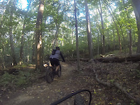
trail: The Phoenix (Red Trail)
0:19 |
164 |
May 17, 2022
Recent Trail Reports
| status | trail | date | condition | info | user |
|---|---|---|---|---|---|
| S.I.R.T. | Apr 18, 2026 @ 4:55pm (America/New_York) Apr 18, 2026 | Ideal | hacksaw3242 | ||
| The Phoenix (Red Trail) | Apr 18, 2026 @ 4:55pm (America/New_York) Apr 18, 2026 | Ideal | hacksaw3242 | ||
| The Phoenix (Red Trail) 4 | Apr 18, 2026 @ 4:55pm (America/New_York) Apr 18, 2026 | Ideal | hacksaw3242 | ||
| Shaolin Connector | Apr 18, 2026 @ 4:55pm (America/New_York) Apr 18, 2026 | Wet | hacksaw3242 | ||
| Auto Shop | Apr 18, 2026 @ 4:55pm (America/New_York) Apr 18, 2026 | Ideal | hacksaw3242 | ||
| Kingdom Trail | Apr 18, 2026 @ 4:55pm (America/New_York) Apr 18, 2026 | Ideal | hacksaw3242 | ||
| Kingdom Trail | Apr 18, 2026 @ 4:55pm (America/New_York) Apr 18, 2026 | Ideal | hacksaw3242 | ||
| Kingdom (Yellow) | Apr 18, 2026 @ 4:55pm (America/New_York) Apr 18, 2026 | Ideal | hacksaw3242 | ||
| Kingdom Trail | Apr 18, 2026 @ 4:55pm (America/New_York) Apr 18, 2026 | Ideal | hacksaw3242 | ||
| The Phoenix (Red Trail) | Apr 10, 2026 @ 4:24pm (America/New_York) Apr 10, 2026 | Ideal | hacksaw3242 |
Activity Feed
| username | action | type | title | date |
|---|---|---|---|---|
| ghostslamr | wishlist | region | activity #96542970 | Jun 8, 2026 @ 8:56am Jun 8, 2026 |
| Espesyal13 | wishlist | region | activity #94152536 | May 6, 2026 @ 6:51am May 6, 2026 |
| hacksaw3242 | add | report | activity #92938785 and 8 more | Apr 19, 2026 @ 5:19am Apr 19, 2026 |
| rmcgovern | wishlist | route | activity #92463744 | Apr 12, 2026 @ 5:24am Apr 12, 2026 |
| hacksaw3242 | add | report | activity #92354134 and 12 more | Apr 10, 2026 @ 5:05pm Apr 10, 2026 |
Recent Comments
| username | type | title | comment | date |
|---|---|---|---|---|
| trail | I enjoy this trails tough climbs and quick... | Aug 3, 2024 @ 2:49pm Aug 3, 2024 | ||
| trail | Can’t say enough about this segment. The... | Aug 3, 2024 @ 2:47pm Aug 3, 2024 | ||
| trail | This trail has been some of the toughest... | Aug 3, 2024 @ 2:45pm Aug 3, 2024 | ||
| trail | The work done on this area in Staten Island... | Aug 3, 2024 @ 2:43pm Aug 3, 2024 | ||
| trail | Maybe the fastest and the funniest section. ... | Jul 30, 2024 @ 7:52pm Jul 30, 2024 |
Nearby Areas
| name | distance | ||||
|---|---|---|---|---|---|
| Lemon Creek Tidal Wetland | 0.3 km | ||||
| Bloomingdale Park | 1 | 5 | 1 km | ||
| Mt Loretto North State Forest | 7 | 21 | 1.7 km | ||
| Clay Pit Pond | 4 | 2 km | |||
| Arden Woods | 4 | 2.5 km |
Local Badges
-

Completionist0 awarded
Bike & Skill Parks
| name | type | city | rating |
|---|---|---|---|
| Burkes Bumps | skill park | Staten Island |
Activity Type Stats
| activitytype | trails | distance | descent | descent distance | total vertical | rating | global rank | state rank | photos | reports | routes | ridelogs |
|---|---|---|---|---|---|---|---|---|---|---|---|---|
| Mountain Bike | 51 | 15 miles | 643 ft | 4 miles | 69 ft | #4,677 | #1,668 | 49 | 932 | 9 | 908 | |
| E-Bike | 7 | 1 mile | 13 ft | 1,106 ft | 36 ft | #8,193 | #2,527 | 827 | 26 | |||
| Horse | 1 | 25 | ||||||||||
| Hike | 63 | 17 miles | 682 ft | 4 miles | 69 ft | #6,108 | #2,213 | 932 | 104 | |||
| Trail Running | 61 | 17 miles | 679 ft | 4 miles | 69 ft | #5,992 | #1,878 | 932 | 1 | 11 | ||
| Snowshoe | 42 | 13 miles | 558 ft | 3 miles | 69 ft | #650 | #278 | 60 | 1 | |||
| Nordic Ski | 32 | 9 miles | 348 ft | 2 miles | 69 ft | #969 | #406 | 59 | 1 |
Frequently Asked Questions About Wolfes Pond
▼
What are the highest rated mountain biking trails in Wolfes Pond?
The highest rated mountain biking trails in Wolfes Pond are:
- Pirate Trail (Blue) (4.2/5)
- Kingdom Trail (4.1/5)
- Pirate Trail (Blue) (4.1/5)
- Kingdom (Yellow) (4.1/5)
- Kingdom Trail (4.1/5)
▼
What is the best time of the year to ride in Wolfes Pond?
Based on ride log data, the most popular months to ride in Wolfes Pond are:
- July (18 activities)
- November (8 activities)
- December (7 activities)
▼
Where can I park to ride in Wolfes Pond?
▼
What is the longest trail in Wolfes Pond?
The longest trail in Wolfes Pond is The Phoenix (Red Trail) at 5,236 ft. View all trails sorted by distance.
Activities
Trails
- By markholloway
 Trailforks Map Team & contributors
 - Admins: NYCMTB
- #42691 - 6,052 views
- wolfes pond activity log | embed map of Wolfes Pond mountain bike trails | wolfes pond mountain biking points of interest
Downloading of trail gps tracks in kml & gpx formats is enabled for Wolfes Pond.
You must login to download files.