close
-
Layers w
- Weather Layers
- Pro
- Pro
- Pro
- Pro
- Pro
- Pro
- More Layers
- Pro
- Pro
- Pro
- Pro
-
Upgrade to

3D
Trail Conditions
- Unknown
- Snow Groomed
- Snow Packed
- Snow Covered
- Snow Cover Partial
- Freeze/thaw Cycle
- Icy
- Prevalent Mud
- Wet
- Variable
- Ideal
- Dry
- Very Dry
Trail Flow (Ridden Direction)
Trailforks scans users ridelogs to determine the most popular direction each trail is ridden. A good flowing trail network will have most trails flowing in a single direction according to their intension.
The colour categories are based on what percentage of riders are riding a trail in its intended direction.
The colour categories are based on what percentage of riders are riding a trail in its intended direction.
- > 96%
- > 90%
- > 80%
- > 70%
- > 50%
- < 50%
- bi-directional trail
- no data
Trail Last Ridden
Trailforks scans ridelogs to determine the last time a trail was ridden.
- < 2 days
- < 1 week
- < 2 weeks
- < 1 month
- < 6 months
- > 6 months
Trail Ridden Direction
The intended direction a trail should be ridden.
- Downhill Only
- Downhill Primary
- Both Directions
- Uphill Primary
- Uphill Only
- One Direction
Contribute Details
Colors indicate trail is missing specified detail.
- Description
- Photos
- Description & Photos
- Videos
Trail Popularity ?
Trailforks scans ridelogs to determine which trails are ridden the most in the last 9 months.
Trails are compared with nearby trails in the same city region with a possible 25 colour shades.
Think of this as a heatmap, more rides = more kinetic energy = warmer colors.
- most popular
- popular
- less popular
- not popular
ATV/ORV/OHV Filter
Max Vehicle Width
inches
US Cell Coverage
Legend

Radar Time
Activity Recordings
Trailforks uses anonymized public activity data.
?
Activity Recordings
Trailforks uses anonymized public activity data.
?
Personal Heatmap
▶
Activity Types
all
/
none
▶
Options
2
Date range
month
–
Winter Trails
Warning
A routing network for winter maps does not exist. Selecting trails using the winter trails layer has been disabled.
Missing Trails
Most Popular
Least Popular
Trails are colored based on popularity. The more popular a trail is, the more red. Less popular trails trend towards green.
Jump Magnitude Heatmap
Heatmap of where riders jump on trails. Zoom in to see individual jumps, click circles to view jump details.
BC Backroad Status
![map legend]()
Service Road Atlas is a free to use, community-driven service for viewing and creating reports on the numerous back-country service roads around B.C. and Alberta.

Slope Aspect
Direction the slope faces
Trails Deemphasized
Trails are shown in grey.
Only show trails with no bike usage.
Suggested Layers
Based on selected activity type
Save the current map location and zoom level as your default home location whenever this page is loaded.
Save
No description for Woodside has been added yet!
Login or register to submit one.
Activities Click to view
- Mountain Bike
11 trails
- Gravel Bike
0 trails
- Adaptive Bike
0 trails
- Horse
9 trails
- Hike
48 trails
- Trail Running
48 trails
Region Details
- 3
- 4
- 4
Region Status
Open as of Nov 9, 2025Stats
- Avg Trail Rating
- Trails (view details)
- 38
- Trails Mountain Bike
- 11
- Trails Horse
- 9
- Trails Hike
- 48
- Trails Trail Running
- 48
- Total Distance
- 65 miles
- Total Descent
- 12,084 ft
- Total Vertical
- 2,179 ft
- Highest Trailhead
- 2,271 ft
- Reports
- 89
- Photos
- 27
- Ridden Counter
- 4,032
Sub Regions
-
Huddart County Park
-
Purisima Creek Redwoods Open Space Preserve
- 2
- 4
-
Wunderlich County Park
Popular Woodside Mountain Biking Trails
• 95 ★ 4.3 • 2 miles • 0 ft • 300 •
Beautiful singletrack with views and lush forests. No technical difficulties. Rated blue only for steepness of slope. Steep climbing sections at bottom if ascending. Closed during wet season.
• 60 ★ 2.6 • 3 miles • 1,424 ft • 191 •
This is a steep, slightly beat up fire road with some extremely steep sections. You have to be very strong to climb it without pushing.
• 100 ★ 0.0 • 3,389 ft • 24 ft • 190 •
Popular green difficulty singletrack. This mountain bike primary trail can be used both directions.
• 75 ★ 2.8 • 2 miles • 998 ft • 181 •
A dirt road with rolling dips through a beautiful redwood forest. Fairly steep climbs followed by short level sections to catch your breath. OK down hill for a dirt road. is a funner downhill.
• 70 ★ 3.3 • 2 miles • 20 ft • 161 •
Popular blue difficulty singletrack. This mountain bike primary trail. On average it takes 12 minutes to complete this trail.
• 35 ★ 0.0 • 2 miles • 949 ft • 19 •
Less popular blue difficulty mixed. This multi-use trail can be used both directions and has a moderate overall physical rating with a 949 ft blue climb. Trail visibility is always easy to follow. On average it takes 35 minutes to complete this trail.
• 45 ★ 0.0 • 2,454 ft • 163 ft • 6 •
Moderately popular green difficulty singletrack. This multi-use trail can be used both directions.
• 5 ★ 0.0 • 3,425 ft • 210 ft • 1 •
Less popular green difficulty singletrack. This multi-use trail can be used both directions.
Woodside Mountain Bike Routes
15 miles • 3,258 ft • 5 • Loop •
Three loops at El Corte de Madera starting from the Skeggs Point parking lot. Easy to bail out after 1 or...
17 miles • 3,736 ft • 8 • Loop •
Similar to other "long" loops of Skeggs-n-eggs, this one optimizes climbing to be a little easier, but...
• 13 miles • 2,389 ft • 0 •
• 6 miles • 1,909 ft • 3 •
• 10 miles • 2,878 ft • 5 •
• 6 miles • 1,823 ft • 1 •
Photos of Woodside Mountain Bike
Videos of Woodside Mountain Bike
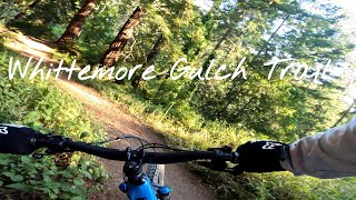
trail: Whittemore Gulch Trail
10:31 |
102 |
Jul 13, 2025 , Woodside
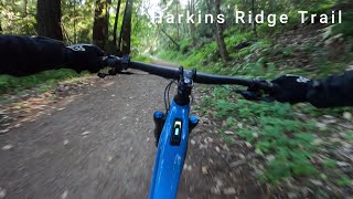
trail: Harkins Ridge Trail
14:06 |
84 |
Jul 12, 2025 , Woodside
Recent Trail Reports
| status | trail | date | condition | info | user |
|---|---|---|---|---|---|
| Whittemore Gulch Trail | Oct 10, 2025 @ 10:17am (America/Los_Angeles) Oct 10, 2025 | Dry | 8eWT8B | ||
| Purisima Creek Trail | Oct 1, 2025 @ 11:40am (America/Los_Angeles) Oct 1, 2025 | Variable | 8eWT8B | ||
| Harkins Ridge Trail | Oct 1, 2025 @ 11:40am (America/Los_Angeles) Oct 1, 2025 | Dry | 8eWT8B | ||
| Cowell Beach Access Trail | Aug 9, 2025 @ 9:36am Aug 9, 2025 | Dry | rumbleman97 | ||
| Woodside Trail | Apr 13, 2025 @ 11:29am Apr 13, 2025 | Unknown | MHxDNUCD | ||
| North Ridge Trail | Jan 23, 2024 @ 4:04pm Jan 23, 2024 | Wet | xciscool | ||
| Grabtown Gulch Trail | Jan 23, 2024 @ 4:03pm Jan 23, 2024 | Wet | xciscool |
Activity Feed
| username | action | type | title | date |
|---|---|---|---|---|
| DfM1rD | wishlist | trail | activity #97533466 | Jun 21, 2026 @ 5:28pm Jun 21, 2026 |
| PatrickOypmBf | wishlist | route | activity #96884705 | Jun 13, 2026 @ 9:04am Jun 13, 2026 |
| carenaw92 | wishlist | trail | activity #96331772 | Jun 5, 2026 @ 5:18pm Jun 5, 2026 |
| Cliskike | wishlist | trail | activity #94793509 | May 16, 2026 @ 12:48am May 16, 2026 |
| Konstadinosk43klu | wishlist | trail | activity #90557024 | Mar 14, 2026 @ 9:08am Mar 14, 2026 |
Recent Comments
| username | type | title | comment | date |
|---|---|---|---|---|
| trail | This trail/fire road has some STEEP pitches on... | Dec 13, 2025 @ 1:52pm Dec 13, 2025 | ||
| trail | If you’d want to climb this, be aware that... | Jul 19, 2025 @ 10:57pm Jul 19, 2025 | ||
| trail | 1,400 foot climb in 3 miles Yeah that will get... | Jul 15, 2025 @ 10:06am Jul 15, 2025 | ||
| trail | Generally pretty boring. A steep fire road.... | Mar 15, 2024 @ 1:15pm Mar 15, 2024 | ||
| trail | Parking lot closed for storm repairs. No... | Jun 29, 2023 @ 2:42pm Jun 29, 2023 |
Local Badges
-

Epic Mountain Bike Climb 2k117 awarded -

Climbing 10k Badge38 awarded -

Mountain Biking 100k Badge0 awarded -

Epic Ride Descent 2k117 awarded -

Descent 10k Badge38 awarded -

Descent 100k Badge0 awarded
Activity Type Stats
| activitytype | trails | distance | descent | descent distance | total vertical | rating | global rank | state rank | photos | reports | routes | ridelogs |
|---|---|---|---|---|---|---|---|---|---|---|---|---|
| Mountain Bike | 11 | 18 miles | 3,009 ft | 7 miles | 1,939 ft | #6,772 | #2,265 | 27 | 89 | 1 | 6,002 | |
| Horse | 9 | 15 miles | 2,684 ft | 6 miles | 1,503 ft | #2,254 | #1,249 | 6 | ||||
| Hike | 48 | 65 miles | 12,083 ft | 27 miles | 2,178 ft | #3,469 | #1,224 | 89 | 3 | 1,251 | ||
| Trail Running | 48 | 65 miles | 12,083 ft | 27 miles | 2,178 ft | #3,503 | #1,040 | 89 | 477 |
Frequently Asked Questions About Woodside
▼
What are the best places to ride in Woodside?
Woodside has 3 areas to explore for mountain biking. The top rated areas are:
▼
What are the highest rated mountain biking trails in Woodside?
The highest rated mountain biking trails in Woodside are:
- Whittemore Gulch Trail (4.2/5)
- Grabtown Gulch Trail (3.6/5)
- Borden Hatch Mill Trail (3.5/5)
- Harkins Ridge Trail (2.9/5)
- Woodside Trail (0/5)
▼
What is the best time of the year to ride in Woodside?
Based on ride log data, the most popular months to ride in Woodside are:
- November (25 activities)
- October (25 activities)
- December (24 activities)
▼
Where can I park to ride in Woodside?
There are 10 parking locations listed in Woodside. The most popular parking spots are: View all parking and trailhead locations on the map to plan your visit.
Activities
Trails
Points of Interest
- By brenthillier
 NSMBA TRAILFORKS & contributors
 - Admins: COB
- #7905 - 5,524 views
- woodside activity log | embed map of Woodside mountain bike trails | woodside mountain biking points of interest
Downloading of trail gps tracks in kml & gpx formats is enabled for Woodside.
You must login to download files.