close
-
Layers w
- Weather Layers
- Pro
- Pro
- Pro
- Pro
- Pro
- Pro
- More Layers
- Pro
- Pro
- Pro
- Pro
-
Upgrade to

3D
Trail Conditions
- Unknown
- Snow Groomed
- Snow Packed
- Snow Covered
- Snow Cover Partial
- Freeze/thaw Cycle
- Icy
- Prevalent Mud
- Wet
- Variable
- Ideal
- Dry
- Very Dry
Trail Flow (Ridden Direction)
Trailforks scans users ridelogs to determine the most popular direction each trail is ridden. A good flowing trail network will have most trails flowing in a single direction according to their intension.
The colour categories are based on what percentage of riders are riding a trail in its intended direction.
The colour categories are based on what percentage of riders are riding a trail in its intended direction.
- > 96%
- > 90%
- > 80%
- > 70%
- > 50%
- < 50%
- bi-directional trail
- no data
Trail Last Ridden
Trailforks scans ridelogs to determine the last time a trail was ridden.
- < 2 days
- < 1 week
- < 2 weeks
- < 1 month
- < 6 months
- > 6 months
Trail Ridden Direction
The intended direction a trail should be ridden.
- Downhill Only
- Downhill Primary
- Both Directions
- Uphill Primary
- Uphill Only
- One Direction
Contribute Details
Colors indicate trail is missing specified detail.
- Description
- Photos
- Description & Photos
- Videos
Trail Popularity ?
Trailforks scans ridelogs to determine which trails are ridden the most in the last 9 months.
Trails are compared with nearby trails in the same city region with a possible 25 colour shades.
Think of this as a heatmap, more rides = more kinetic energy = warmer colors.
- most popular
- popular
- less popular
- not popular
ATV/ORV/OHV Filter
Max Vehicle Width
inches
US Cell Coverage
Legend

Radar Time
Activity Recordings
Trailforks uses anonymized public activity data.
?
Activity Recordings
Trailforks uses anonymized public activity data.
?
Personal Heatmap
▶
Activity Types
all
/
none
▶
Options
2
Date range
month
–
Winter Trails
Warning
A routing network for winter maps does not exist. Selecting trails using the winter trails layer has been disabled.
Missing Trails
Most Popular
Least Popular
Trails are colored based on popularity. The more popular a trail is, the more red. Less popular trails trend towards green.
Jump Magnitude Heatmap
Heatmap of where riders jump on trails. Zoom in to see individual jumps, click circles to view jump details.
BC Backroad Status
![map legend]()
Service Road Atlas is a free to use, community-driven service for viewing and creating reports on the numerous back-country service roads around B.C. and Alberta.

Slope Aspect
Direction the slope faces
Trails Deemphasized
Trails are shown in grey.
Only show trails with no bike usage.
Suggested Layers
Based on selected activity type
Save the current map location and zoom level as your default home location whenever this page is loaded.
Save
No description for Yonkers has been added yet!
Login or register to submit one.
Activities Click to view
- Mountain Bike
60 trails
- Gravel Bike
1 trails
- Adaptive Bike
0 trails
- Winter Fat Bike
0 trails
- Hike
60 trails
- Trail Running
60 trails
Region Details
- 4
- 4
- 17
- 4
Region Status
Caution as of Jun 15, 2026Stats
- Avg Trail Rating
- Trails (view details)
- 29
- Trails Mountain Bike
- 60
- Trails E-Bike
- 2
- Trails Gravel Bike
- 1
- Trails Hike
- 60
- Trails Trail Running
- 60
- Total Distance
- 16 miles
- Total Descent
- 2,035 ft
- Total Vertical
- 245 ft
- Highest Trailhead
- 382 ft
- Reports
- 473
- Photos
- 124
- Ridden Counter
- 17,387
Sub Regions
-
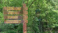
Sprain Ridge Park
- 4
- 17
- 4
Popular Yonkers Mountain Biking Trails
• 85 ★ 4.2 • 2,943 ft • 157 ft • 966 •
Highly rated popular blue difficulty singletrack. This mountain bike primary trail. On average it takes 12 minutes to complete this trail.
• 80 ★ 4.3 • 1 mile • 169 ft • 931 •
Lots of small features and great flow. This trail climbs and descends repeatedly making it fun in both directions. The climbs are not overly taxing so it makes for a good warm up.
• 100 ★ 0.0 • 545 ft • 0 ft • 848 •
Popular blue difficulty singletrack. This mountain bike primary trail can be used both directions and has a easy overall physical rating with a 0 ft blue climb. On average it takes 1 minutes to complete this trail.
• 90 ★ 3.8 • 1,453 ft • 0 ft • 835 •
Popular blue difficulty singletrack. This mountain bike primary trail can be used both directions and has a easy overall physical rating with a 0 ft blue climb. On average it takes 2 minutes to complete this trail.
• 70 ★ 4.2 • 1,657 ft • 0 ft • 811 •
Fun downhill with small rock drops and twisty sections
• 90 ★ 4.0 • 1,742 ft • 44 ft • 771 •
Popular blue difficulty singletrack. This mountain bike primary trail can be used both directions and has a easy overall physical rating with a 44 ft blue climb. On average it takes 3 minutes to complete this trail.
• 80 ★ 5.0 • 3,635 ft • 138 ft • 763 •
Built with the cooperation of the Westchester Mountain Bike Association and the NY NICA riders and coaches. A level, mellow winding trail with a gradual slope up or down depending on direction ridden.
• 70 ★ 2.0 • 1,276 ft • 14 ft • 750 •
Popular green difficulty mixed. This mountain bike primary trail can be used both directions and has a easy overall physical rating with a 14 ft green climb. On average it takes 2 minutes to complete this trail.
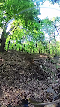
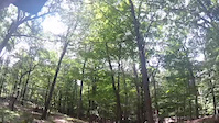
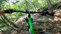
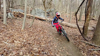
Photos of Yonkers Mountain Bike
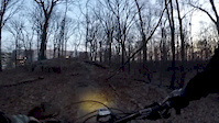
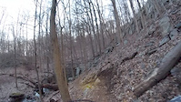
Videos of Yonkers Mountain Bike
trail: Soccer Mom
0:16 |
27 |
Oct 28, 2025
trail: Valley Trail
0:13 |
118 |
Aug 6, 2023
0:30 |
317 |
Sep 30, 2020
7:17 |
335 |
Jun 9, 2019
2:11 |
465 |
Jan 13, 2019
0:28 |
204 |
Apr 6, 2018
trail: No Way Jose
0:31 |
482 |
Apr 6, 2018

0:54 |
217 |
Apr 6, 2018
Recent Trail Reports
| status | trail | date | condition | info | user |
|---|---|---|---|---|---|
| N. Brothers Loop - Dannys Cycles - WMBA Trail Hunt | Jun 15, 2026 @ 2:01pm (America/New_York) Jun 15, 2026 | Unknown | mykejuliet | ||
| S Car Go | Jun 15, 2026 @ 2:00pm (America/New_York) Jun 15, 2026 | Ideal | mykejuliet | ||
| Cocoa | Dec 12, 2025 @ 9:55am (America/New_York) Dec 12, 2025 | Freeze/thaw Cycle | Staktup PWMBA | ||
| No Way Jose connector (to "REI Trails") | Aug 19, 2025 @ 3:17pm Aug 19, 2025 | Unknown | ed1028 | ||
| Eric's Over the Log | Jul 24, 2025 @ 10:13am Jul 24, 2025 | Unknown | ed1028 | ||
| O2A | Jul 23, 2025 @ 12:02pm Jul 23, 2025 | Unknown | ed1028 | ||
| Soccer Mom | Jul 19, 2025 @ 2:11pm Jul 19, 2025 | Ideal | fat-old-guy | ||
| Charcoal | Jul 19, 2025 @ 2:11pm Jul 19, 2025 | Ideal | fat-old-guy | ||
| Skull Twist | Jul 19, 2025 @ 2:11pm Jul 19, 2025 | Ideal | fat-old-guy | ||
| Beginner Trail bypass | Jul 19, 2025 @ 2:11pm Jul 19, 2025 | Ideal | fat-old-guy |
Activity Feed
| username | action | type | title | date |
|---|---|---|---|---|
| nmgold | comment | report | activity #97055776 | Jun 15, 2026 @ 11:36am Jun 15, 2026 |
| mykejuliet | add | report | activity #97053314 and 1 more | Jun 15, 2026 @ 11:00am Jun 15, 2026 |
| mykejuliet | comment | report | activity #97053248 | Jun 15, 2026 @ 10:59am Jun 15, 2026 |
| nmgold | add | report | activity #96884833 and 1 more | Jun 13, 2026 @ 9:05am Jun 13, 2026 |
| ed1028 | add | report | activity #96706086 | Jun 10, 2026 @ 5:24pm Jun 10, 2026 |
Recent Comments
| username | type | title | comment | date |
|---|---|---|---|---|
| report | well thank you Mike! been a long time, hope... | Jun 15, 2026 @ 11:36am Jun 15, 2026 | ||
| report | Has been rectified. Now open for KOM’s | Jun 15, 2026 @ 10:59am Jun 15, 2026 | ||
| report | Parks guys have been notified about these.... | Jun 9, 2026 @ 4:23am Jun 9, 2026 | ||
| trail | Such a fun trail, it is all downhill so you... | Sep 23, 2025 @ 3:06pm Sep 23, 2025 | ||
| report | Yes Sprain has Ticks. Yes maintenance has been... | Oct 16, 2024 @ 4:05am Oct 16, 2024 |
Local Badges
-

10 Blue Trails497 awarded -

Epic Ride Climb 2k11 awarded -

Climbing 10k Badge53 awarded -

Climbing 100k Badge2 awarded -

Epic Ride Descent 2k11 awarded -

Descent 10k Badge54 awarded
Activity Type Stats
| activitytype | trails | distance | descent | descent distance | total vertical | rating | global rank | state rank | photos | reports | routes | ridelogs |
|---|---|---|---|---|---|---|---|---|---|---|---|---|
| Mountain Bike | 60 | 16 miles | 2,034 ft | 6 miles | 246 ft | #1,018 | #401 | 124 | 473 | 14,157 | ||
| E-Bike | 2 | 1,063 ft | 20 ft | 436 ft | 23 ft | 349 | 800 | |||||
| Gravel Bike | 1 | #724 | #1,226 | 4 | ||||||||
| Hike | 60 | 16 miles | 2,034 ft | 6 miles | 246 ft | #7,270 | #2,569 | 473 | 143 | |||
| Trail Running | 60 | 16 miles | 2,034 ft | 6 miles | 246 ft | #6,687 | #2,180 | 473 | 83 |
Frequently Asked Questions About Yonkers
▼
What are the best places to ride in Yonkers?
Yonkers has 1 areas to explore for mountain biking. The top rated areas are:
▼
What are the highest rated mountain biking trails in Yonkers?
The highest rated mountain biking trails in Yonkers are:
- Beginner Trail (4.4/5)
- Charcoal (4.3/5)
- Soccer Mom (4.2/5)
- Cocoa (4.2/5)
- Bean's loop (4.2/5)
▼
What is the best time of the year to ride in Yonkers?
Based on ride log data, the most popular months to ride in Yonkers are:
- June (186 activities)
- May (182 activities)
- July (175 activities)
▼
Where can I park to ride in Yonkers?
Check the Yonkers trail map for trailhead and parking information. Community members regularly update access and parking details for trails in the area.
- By wheelcrazy & contributors
- Admins: PWMBA
- #4671 - 6,015 views
- yonkers activity log | embed map of Yonkers mountain bike trails | yonkers mountain biking points of interest
Downloading of trail gps tracks in kml & gpx formats is enabled for Yonkers.
You must login to download files.